

Domestic subsidence insurance claims in the UK reached £153 million in the first half of 2026 alone, supporting close to 9,000 households with average payouts of around £17,000,£18,000 [3][7]. Behind those figures lies a growing crisis driven by repeated drought, shrinking clay soils, and foundations that were never designed for the climate conditions now becoming routine. For anyone buying a property in 2026, understanding what professional subsidence investigations involve, and how UK chartered surveyors approach them, is no longer optional. It is one of the most consequential steps in the entire purchase process.
This guide explains precisely what professional subsidence investigations cover, what UK chartered surveyors look for before you buy, how their findings shape lender decisions, and when specialist input becomes essential.
Key Takeaways
- Subsidence risk has escalated sharply in 2026, with drought declared across half of England and millions of homes in London, Essex and Kent identified as at elevated risk of ground movement [1][8].
- Chartered surveyors assess crack patterns, soil type, drainage, tree proximity and prior claim history as core elements of a professional subsidence investigation.
- RICS updated its environmental surveying competencies in December 2025 to formalise ground engineering and subsidence as a required technical skill area [5].
- A surveyor's report directly influences mortgage lender decisions, insurance availability and buyer negotiating power.
- When a surveyor identifies active or suspected subsidence, referral to a specialist structural engineer or geotechnical consultant is standard practice, not a sign of failure.
Why Subsidence Risk Has Become a Critical Issue in 2026
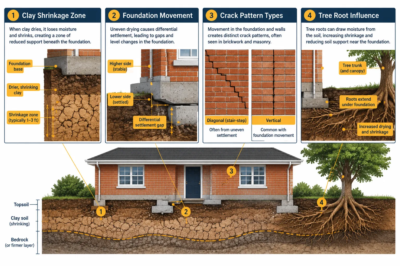
The physical drivers of subsidence are well understood, but their intensity has changed dramatically. Subsidence occurs when the ground beneath a building loses volume or support, causing foundations to move unevenly. In the UK, the dominant cause is shrinkage of clay soils during dry periods, a process that has accelerated sharply as heatwaves become more frequent and severe.
Recent analysis identified millions of homes in London, Essex and Kent at increased risk of "sinking" as hotter, drier weather shrinks clay soils and destabilises foundations [1]. By mid-2026, drought had been formally declared across large parts of England, the third such declaration in five years, following 2022 and 2025 [8]. Bloomberg analysis confirmed that London is experiencing record subsidence risk levels driven directly by repeated heatwaves [9].
"Surveyors and insurers now treat many clay-rich regions as chronically exposed, not just occasionally at risk."
This shift matters enormously for professional subsidence investigations. Where surveyors once assessed a property against a backdrop of occasional dry summers, they must now factor in long-term soil moisture deficit, repeated heatwave cycles, and a trajectory of worsening conditions [6][11]. The question is no longer whether a property sits on shrinkable clay, it is how much cumulative stress that clay has already experienced, and what further movement is likely.
For buyers, this context reshapes the entire due diligence process. Understanding what building survey scope now covers under 2026 assessment proposals helps set realistic expectations about the depth of investigation required.
What Professional Subsidence Investigations: What UK Chartered Surveyors Look For Before You Buy Actually Covers
Professional subsidence investigations are not a single test. They are a structured, multi-stage assessment that a RICS-qualified chartered surveyor conducts to determine whether a property has experienced, is experiencing, or is at meaningful risk of ground movement. The scope has been formalised by RICS, whose updated environmental surveying competencies (published December 2025) explicitly require chartered surveyors to demonstrate detailed understanding of rock and soil mechanics, natural and mining-induced subsidence, and available mitigation and remedial options [5].
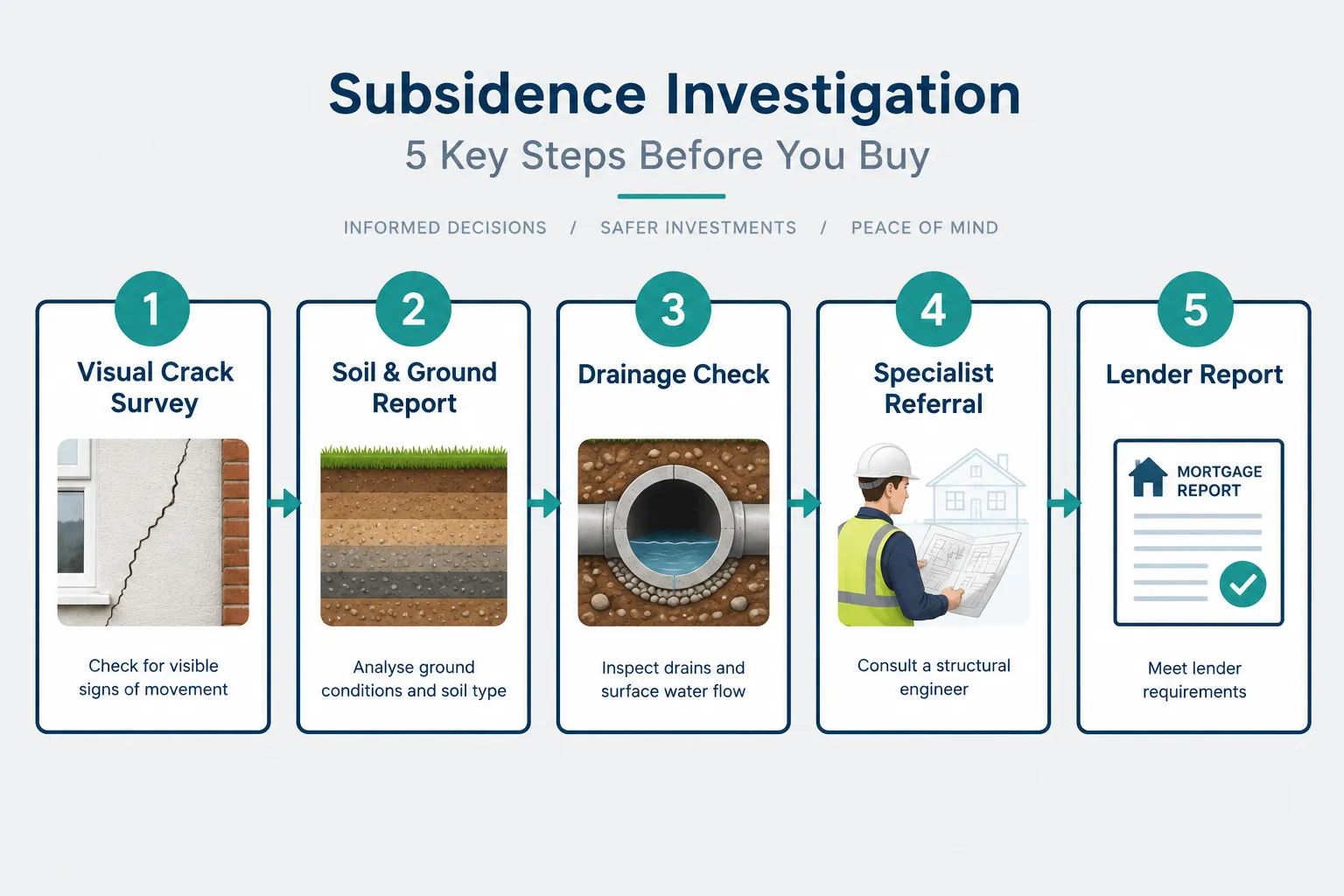
Stage 1: Visual Survey of the Building Fabric
The first and most visible element is a systematic inspection of the building's fabric for signs of structural movement. Surveyors are trained to distinguish between cosmetic cracking and structurally significant movement. Key indicators include:
- Diagonal stair-step cracks in brickwork, particularly at corners and around window and door openings
- Tapered cracks that are wider at the top than the bottom, suggesting differential settlement
- Cracks that have been previously filled and have re-opened, a strong indicator of ongoing movement
- Distorted door and window frames that no longer close squarely
- Sloping floors or visible lean in external walls
The Building Research Establishment's crack classification system (BRE Digest 251) provides the framework surveyors use to grade crack severity from Category 0 (hairline, negligible) through to Category 5 (very severe, requiring major repair). A chartered surveyor will note not just the width of a crack but its orientation, location, whether it is live or historic, and whether it is consistent with subsidence or another cause such as thermal movement or poor construction.
Stage 2: Ground Conditions and Soil Type Assessment
Visual evidence alone is insufficient. A professional subsidence investigation requires the surveyor to assess the ground conditions beneath and around the property. This involves:
- Reviewing geological maps to establish whether the property sits on shrinkable clay (particularly London Clay, Gault Clay or similar formations)
- Checking British Geological Survey (BGS) data on soil shrink-swell potential
- Assessing local topography, properties on slopes or near watercourses carry different risk profiles
- Considering historical land use, including whether the site was previously mined, filled or developed on made ground
In 2026, surveyors are also expected to reference local drought history and water-table trends as part of this assessment, given that repeated soil moisture deficit is now a persistent feature of the risk landscape rather than an exceptional event [6][11].
Stage 3: Tree and Vegetation Assessment
Tree roots are a leading cause of clay soil desiccation beneath foundations. During a professional subsidence investigation, surveyors assess:
| Factor | What the Surveyor Checks |
|---|---|
| Species | High water demand trees (oak, poplar, willow, elm) pose greatest risk |
| Proximity | Distance from tree to building relative to mature height |
| Age and condition | Mature trees near older shallow foundations are highest risk |
| Recent removal | Removed trees can cause heave as soil re-wets |
| Root barriers | Whether any protective measures are in place |
Properties with large trees within 10-15 metres on clay soils warrant particular scrutiny. Equally, recently felled trees can cause the opposite problem, soil heave, as moisture levels recover.
Stage 4: Drainage and Services Investigation
Poor or leaking drainage is a significant secondary cause of subsidence. Water escaping from underground pipes can wash away fine soil particles (a process called erosion or "piping"), or saturate ground that then becomes unstable. Surveyors check:
- Condition of visible drainage runs and inspection chambers
- Evidence of damp or water ingress at low levels that might indicate drainage failure
- CCTV drainage survey recommendations where drainage condition cannot be visually confirmed
- Proximity of soakaways and whether surface water management is adequate
For older properties, this stage is particularly important. Buyers considering older homes should also review what to look out for when buying an old house to understand how drainage and foundation issues interact across different construction eras.
Stage 5: Prior Claim History and Insurance Position
One of the most consequential elements of a professional subsidence investigation is establishing whether the property has a prior subsidence claim history. This matters for three reasons:
- Ongoing risk: A property that has subsided before is statistically more likely to subside again, particularly if the underlying cause was not fully remediated.
- Insurance availability: Many standard insurers will decline cover or apply significant exclusions to properties with subsidence history. Specialist insurers exist but charge materially higher premiums.
- Lender comfort: Mortgage lenders require buildings insurance as a condition of lending. If a surveyor flags insurability concerns, the transaction can stall or collapse.
With average subsidence claim severity rising from approximately £16,300 in Q1 2025 to roughly £20,000 in Q2 2026, three to four times headline CPI inflation over the same period, the financial stakes are significant for both buyers and their lenders [7][8]. Surveyors now routinely advise buyers to obtain a formal insurance position statement before exchange of contracts.
How Surveyors Assess, Report and Escalate: The Professional Subsidence Investigation in Practice
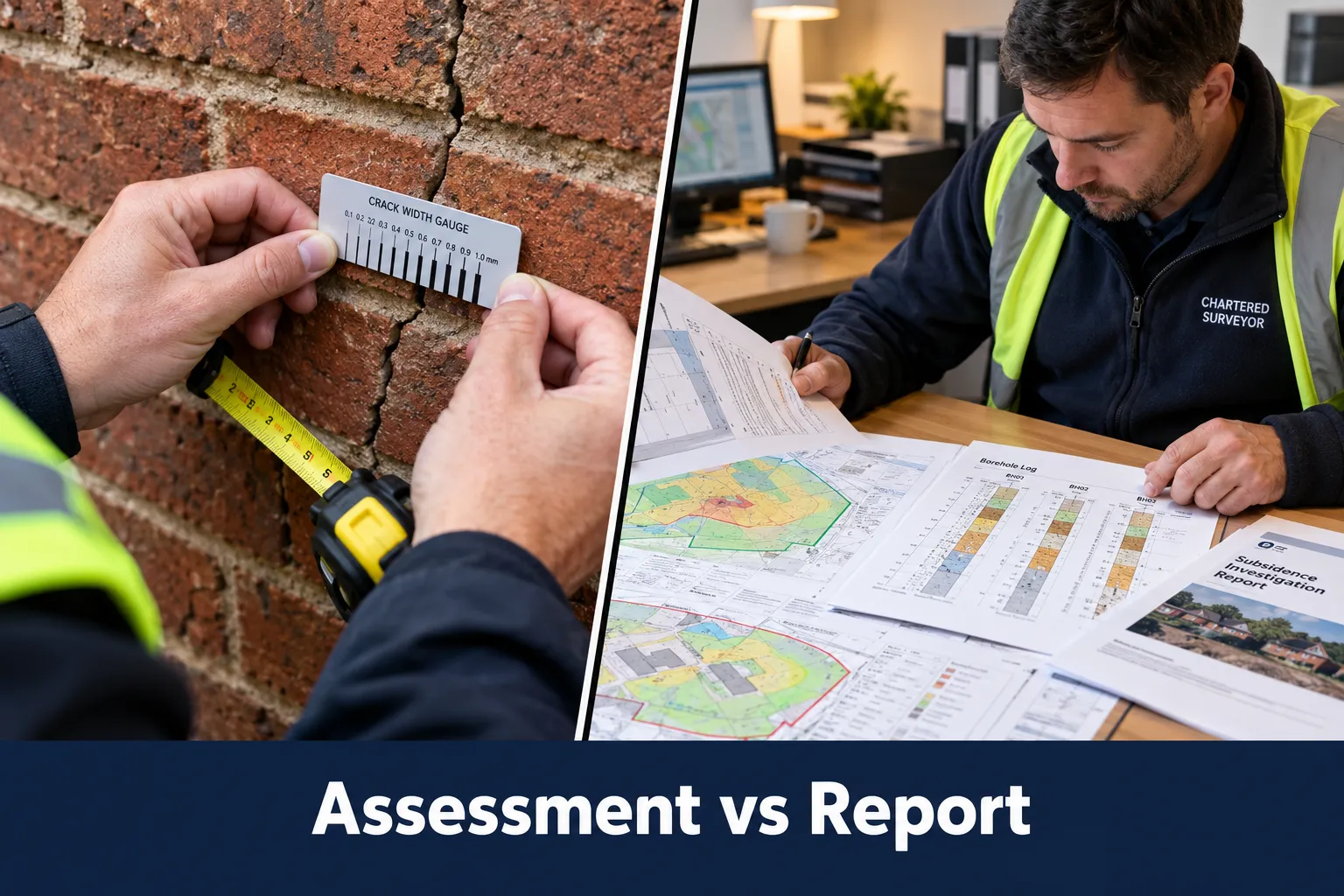
The output of a professional subsidence investigation is a structured written report that communicates findings in a format accessible to both buyers and mortgage lenders. Under RICS Home Survey Standards, surveyors use a condition rating system (1 = no repair needed, 2 = repair/maintenance required, 3 = urgent investigation needed) to classify findings. A condition rating of 3 applied to structural movement or suspected subsidence triggers a clear recommendation for further specialist investigation.
When Surveyors Recommend Specialist Input
A chartered surveyor conducting a building survey is a generalist professional with broad competency across building pathology. Subsidence, however, can require specialist geotechnical or structural engineering input that goes beyond the scope of a standard survey. Surveyors will typically recommend specialist referral when:
- Cracks are wide (Category 3 or above on the BRE scale), recent, or clearly progressive
- Ground conditions suggest high shrink-swell potential combined with evidence of movement
- There is a history of underpinning on the property or on adjacent properties
- Mining legacy is identified in the area
- The drainage investigation reveals significant defects that could be causing or contributing to movement
This referral is not a weakness in the surveyor's assessment, it is the correct professional response. RICS competency standards specifically require surveyors to know when specialist input is needed and to communicate that clearly to clients [5].
The Role of Monitoring
In some cases, a surveyor may recommend that crack movement be monitored over a period of weeks or months before a definitive assessment is possible. Tell-tale gauges or demec studs can be installed to measure whether cracks are active, seasonal (opening in summer, closing in winter) or historic and stable. For buyers with a tight transaction timeline, this creates a dilemma, but proceeding without that information carries significant financial risk.
How the Report Influences Lender Decisions
Mortgage lenders rely heavily on the surveyor's report when deciding whether to lend and on what terms. A report that identifies suspected active subsidence will typically result in one of three outcomes:
- Retention: The lender withholds a portion of the mortgage advance until remediation is completed and verified.
- Decline: The lender refuses to lend until a full specialist investigation and, if necessary, remediation is completed.
- Conditional approval: Lending proceeds subject to the buyer obtaining specialist reports, revised insurance terms, and sometimes a price reduction.
Buyers should understand that a surveyor's report is not just a document for their own information, it is a key input into the lender's risk assessment. The RICS homebuying reforms of 2026 and how mandatory upfront surveys will reshape chartered surveyor workflows are making this connection even more direct, with survey findings increasingly shared earlier in the transaction process.
Using Professional Subsidence Investigation Findings in Buyer Negotiations
A surveyor's findings on subsidence are among the most powerful negotiating tools available to a buyer, provided they are used correctly and in good faith.
Quantifying the Cost of Remediation
If a surveyor identifies evidence of historic subsidence that has been stabilised, the buyer's position depends on whether the cause has been addressed and whether the property is now insurable on reasonable terms. The cost of underpinning a property can range from £5,000 for a small localised repair to £50,000 or more for a full perimeter underpinning of a larger property. These figures, supported by the surveyor's report and specialist quotes, provide a rational basis for price renegotiation.
Distinguishing Historic from Active Movement
Not all subsidence findings are equal. A surveyor who can clearly demonstrate that cracking is historic, stable and consistent with a one-off event (such as the 1976 drought) provides a very different risk picture from one who identifies progressive, active movement. Buyers should ask their surveyor explicitly:
- Is this movement active or historic?
- Has the cause been identified and addressed?
- What is the likely cost range of remediation if movement is active?
- What is the surveyor's view on insurability?
Subsidence and Property Valuation
Confirmed or suspected active subsidence will depress a property's market value, sometimes significantly. Surveyors with valuation expertise can advise on the extent to which the market would discount a property given its specific circumstances. For context on how regional market conditions affect this calculation in 2026, the valuation methodology for flat markets in London and the South East is particularly relevant given that London and the South East are disproportionately represented in the current subsidence risk data [1][9].
The Evolving Standards Governing Professional Subsidence Investigations
The professional framework governing subsidence investigations has been strengthened in response to the worsening risk environment. RICS published updated environmental surveying competency requirements in December 2025, formally embedding "ground engineering and subsidence" as a distinct competency area requiring demonstrated understanding of soil mechanics, natural and mining-induced subsidence, and remedial options [5].
This formalisation matters for buyers in two ways. First, it means that a RICS-qualified chartered surveyor conducting a building survey in 2026 is held to a higher and more specific standard on subsidence than was the case five years ago. Second, it provides buyers with a clear basis for checking that their surveyor has the relevant competency, and for raising concerns if a report appears superficial.
The RICS Home Survey Standards updates for 2026 also reflect enhanced requirements for consumer-facing communication, meaning that subsidence findings should be explained clearly in plain language, not buried in technical caveats.
Digital Tools Enhancing Subsidence Assessments
Chartered surveyors are increasingly using digital tools to enhance the rigour of subsidence assessments. Geographic information system (GIS) overlays allow surveyors to cross-reference a property's precise location against BGS shrink-swell data, historical drought records, tree canopy maps and drainage infrastructure in a single analytical step. For more on how these tools are being deployed, see GIS integration for property surveyors and overlaying data for smarter land use decisions in 2026.
3D digital twin technology is also beginning to appear in higher-specification surveys, allowing surveyors to model foundation conditions and visualise potential movement scenarios before purchase. The implications of this for buyers are explored in real-time 3D digital twins for property surveys and visualising risks before purchase.
Conclusion: Actionable Steps for Buyers Commissioning a Professional Subsidence Investigation
The evidence from 2026 is unambiguous: subsidence risk is rising, the financial consequences of missing it are severe, and the professional standards governing its assessment have never been more rigorous. For buyers, the following steps are essential.
Before commissioning a survey:
- Check the BGS National Shrinkage Potential dataset for the property's location.
- Ask the estate agent directly whether there is any known subsidence history or prior insurance claims.
- Confirm that your chosen surveyor holds RICS membership and has demonstrated competency in ground engineering and subsidence.
When commissioning the survey:
- Commission a Level 3 Building Survey (formerly Full Structural Survey) rather than a Level 2 HomeBuyer Report if the property is older, has visible cracking, sits on clay, or has large trees nearby.
- Ask the surveyor explicitly whether the survey scope includes assessment of ground conditions, drainage and vegetation risk.
After receiving the report:
- If the report flags suspected subsidence at Condition Rating 3, instruct a specialist structural engineer or geotechnical consultant before proceeding.
- Obtain an insurance quotation before exchange, not after, so that any insurability issues are known while you still have negotiating leverage.
- Use the surveyor's findings as the basis for a quantified price renegotiation if remediation costs are identified.
Professional subsidence investigations are not a bureaucratic formality. In 2026, with drought-driven clay shrinkage now a persistent feature of the UK climate and claim costs rising at multiples of inflation [7][8], they are one of the most financially protective steps any property buyer can take.
References
[1] Millions Homes London Essex And Kent Sinking Climate Crisis Subsidence – theguardian.com
[2] Britains Homescracking Under Strain Heatwaves – telegraph.co.uk
[3] Rebuild Costs Are Outpacing Sums Insured Bcis Says Drought Is Making It Worse – insurancebusinessmag.com
[4] Insurance Journal International News – insurancejournal.com
[5] Environmental Surveying December 2025 – rics.org
[6] Third Heatwave Of 2026 Renews Subsidence And Wildfire Risk Warnings For Insurers – insurancebusinessmag.com
[7] UK Subsidence Payouts Rise To 72 Million In Q2 ABI Says – theinsurer.com
[8] Half Of England Declared In Drought As Insurers Face Exposure Beyond Subsidence – insurancebusinessmag.com
[9] Heat Waves Are Fueling Record Subsidence Risk In London – bloomberg.com
[10] Fourth UK Heatwave Piles Pressure On Insurers Facing Record Claims – insurancebusinessmag.com