

Surveyors who once spent days measuring a single building with tape measures and theodolites can now walk the same space in under an hour and leave with a centimeter-accurate, fully navigable digital replica. That shift is not a forecast — it is the operational reality driving adoption of mobile 3D mapping techniques: creating digital twins for indoor and outdoor property surveys in 2026 across construction, real estate, and urban planning sectors worldwide.
Key Takeaways
- Mobile mapping systems combining LiDAR, high-resolution cameras, and inertial measurement units (IMUs) now deliver survey-grade accuracy without fixed, bulky equipment.
- Digital twins created from mobile 3D scans support real-time building monitoring, maintenance planning, and energy optimization.
- Lightweight backpack and handheld systems make rapid indoor and outdoor capture practical for properties of any size or complexity.
- AI-driven processing platforms are compressing post-processing timelines from days to hours, accelerating project delivery.
- Integrating mobile 3D data with existing workflows — from BIM to facility management software — unlocks the full commercial value of each survey.
What Are Mobile 3D Mapping Systems and Why Do They Matter in 2026
At their core, mobile mapping systems are platforms that carry sensors through an environment to collect spatial data continuously. Unlike static terrestrial laser scanners, which must be repositioned at dozens of fixed stations, mobile systems capture data on the move — dramatically reducing survey time and cost.
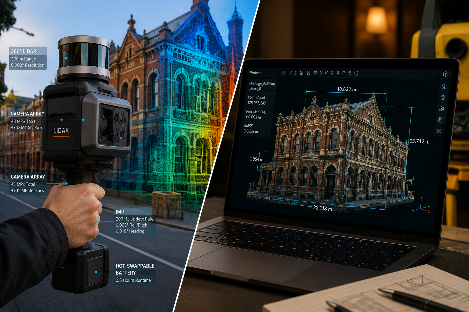
Modern platforms integrate three primary sensor types [1]:
| Sensor | Primary Function | Typical Accuracy |
|---|---|---|
| LiDAR scanner | Distance measurement via laser pulses | +/- 1-3 mm |
| High-resolution camera | Colorizing point clouds, photogrammetry | Sub-pixel |
| Inertial Measurement Unit (IMU) | Tracking position and orientation | Centimeter-level |
These components are packaged into vehicle-mounted rigs for large-scale outdoor surveys, UAV (drone) payloads for elevated perspectives, or — most relevantly for property work — backpack and handheld systems that a single operator can carry through any space.
The result is a dense, georeferenced point cloud: a three-dimensional constellation of millions of measured points that forms the raw material for a digital twin. LiDAR scanners used in professional as-built surveys routinely achieve accuracy of +/- 1-3 mm, and the data is directly compatible with industry-standard software including Revit, AutoCAD, and Rhino [6].
For property professionals considering the range of survey options available, understanding what types of building surveys are available provides useful context for where mobile 3D mapping fits within the broader toolkit.
Core Technologies Powering Mobile 3D Mapping Techniques for Property Surveys
LiDAR: The Accuracy Backbone
LiDAR (Light Detection and Ranging) remains the gold standard for spatial accuracy in professional surveys. By emitting rapid laser pulses and measuring return times, LiDAR systems build dense point clouds that capture every surface — walls, ceilings, structural elements, and external facades — with millimeter precision [6].
For property surveys, this matters enormously. A point cloud accurate to 2 mm can reveal settlement cracks, out-of-plumb walls, and roof deflections that a tape measure would miss entirely.
Camera Systems: Color, Detail, and Photogrammetry
Point clouds alone are geometrically rich but visually sparse. High-resolution cameras mounted alongside LiDAR sensors colorize each point, producing photorealistic models that clients and stakeholders can navigate intuitively. The quality of these cameras directly affects the quality of the final digital twin [5].
Key camera specifications that matter for property surveys include:
- Global shutter — eliminates motion blur when the operator is walking
- High Dynamic Range (HDR) — captures detail in both bright exterior zones and shadowed interior corners simultaneously
- Wide field of view — reduces the number of passes needed to cover a space
IMUs and GNSS: Knowing Where You Are
An IMU tracks the orientation and acceleration of the mapping platform continuously, while GNSS (GPS) anchors the dataset to real-world coordinates outdoors. In GNSS-denied environments — basements, underground car parks, dense urban canyons — Simultaneous Localisation and Mapping (SLAM) algorithms take over, using the scan data itself to compute position.
The PolyU-BPCoMa dataset, which integrates 3D LiDAR, spherical imaging, GNSS, and IMU on a backpack platform, has become a key benchmarking reference for evaluating the accuracy of these combined systems in real-world conditions [1].
AI-Powered Processing
Raw point clouds require processing before they become usable digital twins. AI-driven platforms are now capable of automating much of this work — classifying surfaces, detecting structural elements, generating floor plans, and even flagging anomalies. Platforms offering AI-driven 3D modeling from street-level to indoor environments are enabling city-scale digital twins without the need for drones or aerial photogrammetry in every case [3].
Indoor Mobile Mapping: Rapid Surveys Without Bulky Gear

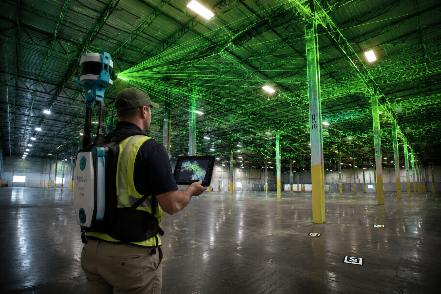
The indoor application of mobile 3D mapping is where the technology's agility becomes most commercially compelling. Traditional static scanners require setup at multiple stations, with each scan taking several minutes. A backpack or handheld system, by contrast, captures continuously as the operator walks — meaning a 5,000 sq ft office floor can be scanned in under 30 minutes [2].
Practical Applications for Indoor Property Surveys
Facility management is one of the highest-value use cases. Digital twins of large buildings — airports, hospitals, government offices, factories — allow facility managers to plan maintenance, model refurbishment scenarios, and manage assets without returning to site for every query [2].
Virtual walkthroughs generated from indoor scans are increasingly used in commercial property transactions, allowing remote buyers and tenants to assess spaces accurately before committing to physical visits.
BIM integration is another critical driver. Architects and contractors working on refurbishment projects need accurate as-built drawings. Mobile scanning delivers these faster and more accurately than manual measurement, and the resulting models feed directly into BIM workflows.
For properties undergoing detailed assessment, the data gathered through mobile mapping can complement a Level 3 full building survey, providing precise spatial context for material assessments and defect analysis.
HoloLens 2 and Low-Cost Scanning Options
Research published in 2025 assessed the Microsoft HoloLens 2 as a low-cost 3D scanning tool for BIM applications, comparing its output against conventional terrestrial laser scanners and handheld mobile laser scanning devices [7]. The findings confirmed that while HoloLens 2 offers genuine utility for rapid reconnaissance and early-stage modeling, professional-grade accuracy still requires dedicated LiDAR hardware for surveys where measurements will inform construction decisions.
Earlier research evaluating the original HoloLens for indoor localization and spatial mapping reached similar conclusions — the device excels at rapid spatial awareness but falls short of survey-grade tolerances [10].
The practical takeaway: match the tool to the tolerance required. Low-cost devices work well for preliminary assessments and client presentations; LiDAR-based systems are essential when the data will drive structural or legal decisions.
Outdoor Property Surveys and Urban-Scale Digital Twins
Mobile 3D mapping techniques for creating digital twins extend naturally to outdoor environments, where the scale of data collection makes mobile systems even more advantageous over static alternatives.
Vehicle-Mounted and UAV Systems
For large development sites, streetscapes, and infrastructure corridors, vehicle-mounted mobile mapping rigs cover ground at road speed while capturing centimeter-accurate point clouds of facades, road surfaces, and above-ground utilities. UAV-mounted LiDAR adds the vertical dimension, capturing roof geometry, chimney stacks, and elevated structural features that ground-based systems cannot reach.
Research has demonstrated the effectiveness of teams of mobile ground robots for collaborative 3D mapping of large outdoor areas, with applications spanning precision agriculture, search and rescue, and industrial inspection [9]. The same multi-agent principle applies to construction monitoring, where multiple platforms can survey different zones of a large site simultaneously.
Construction Monitoring and Urban Development
Construction projects benefit from regular mobile 3D surveys that track progress against BIM models, identify deviations from design, and document conditions for contractual purposes. A scan taken weekly or monthly creates a time-stamped record of the build that is invaluable for dispute resolution and quality assurance.
For urban development projects, mobile mapping feeds directly into smart city initiatives. The integration of LiDAR instruments in both static and dynamic implementations is now recognized as a foundational approach for creating digital twins that support smart city planning and real estate asset management [8].
Professionals involved in construction category projects will find that mobile 3D data adds a layer of precision documentation that traditional site photography and manual measurement simply cannot match.
Outdoor Survey Workflow
A typical outdoor mobile 3D mapping workflow follows three stages:
- Pre-survey planning — defining the area of interest, selecting the appropriate platform (vehicle, UAV, or backpack), and establishing ground control points for georeferencing.
- On-site data capture — executing planned scan routes, monitoring data quality in real time, and capturing supplementary photography where needed.
- Post-processing — registering point clouds, colorizing with camera data, generating deliverables (floor plans, elevations, BIM models, or full digital twins).
Digital Twins: From Point Cloud to Operational Asset
A point cloud is raw data. A digital twin is a living, queryable model that mirrors the physical asset and can be updated as the asset changes. The distinction matters commercially.
What Digital Twins Enable for Property Owners
Digital twins created through mobile 3D mapping techniques provide property owners and managers with capabilities that static drawings and photographs cannot [4]:
- Real-time monitoring of building systems (HVAC, electrical, structural sensors) overlaid on the spatial model
- Predictive maintenance — identifying equipment degradation patterns before failure occurs
- Energy optimization — modeling heating, cooling, and lighting loads against actual building geometry
- Renovation planning — testing design options in the digital model before committing to physical work
- Compliance documentation — maintaining accurate records for statutory considerations and regulatory submissions
"Digital twins provide real-time monitoring of building systems, optimizing energy use, reducing maintenance costs, and streamlining facility management — predicting equipment failures before they become costly problems." [4]
Integration with Existing Property Management Workflows
The commercial value of a digital twin multiplies when it connects to existing property management systems. Modern platforms allow digital twins to serve as the spatial backbone for maintenance ticketing, lease management, and asset registers. For block management contexts, this means property inspection records can be anchored to precise locations within the digital model, making it far easier to track recurring issues and plan cyclical maintenance.
For properties being prepared for sale or lease, digital twins created from mobile 3D surveys can integrate with property photography and videography services to produce marketing assets that go far beyond standard imagery — offering prospective buyers or tenants an immersive, accurate spatial experience.
Selecting the Right Mobile Mapping Approach for Your Survey
Not every project requires the same level of technology investment. The table below provides a practical framework for matching mobile 3D mapping techniques to common property survey scenarios in 2026.
| Survey Type | Recommended Platform | Typical Accuracy | Best For |
|---|---|---|---|
| Single residential property | Handheld LiDAR or HoloLens 2 | 5-20 mm | Pre-purchase assessment, renovation planning |
| Commercial building interior | Backpack LiDAR system | 2-5 mm | Facility management, BIM as-built |
| Large industrial or institutional | Backpack + static LiDAR hybrid | 1-3 mm | Refurbishment, compliance documentation |
| Development site (outdoor) | Vehicle-mounted or UAV LiDAR | 2-10 mm | Construction monitoring, planning submissions |
| Urban streetscape / smart city | Vehicle-mounted mobile mapping | 5-20 mm | Infrastructure management, digital twin city models |
When commissioning a mobile 3D survey, key questions to ask include:
- What accuracy tolerance does the downstream use case require?
- Will the data need to integrate with BIM software or a specific facility management platform?
- How frequently will the model need to be updated?
- Is GNSS available throughout the survey area, or will SLAM-based positioning be required indoors?
Understanding how long a building survey takes in conventional terms helps set realistic expectations when comparing traditional survey timelines against the accelerated capture speeds that mobile 3D systems offer.
Challenges and Limitations to Consider
Mobile 3D mapping is powerful, but it is not without constraints. Professionals adopting these techniques should be aware of the following:
Reflective and transparent surfaces — glass, polished metal, and water cause LiDAR returns to scatter or fail entirely, creating voids in the point cloud that require supplementary data collection.
Dense vegetation outdoors — foliage absorbs laser pulses, making it difficult to capture ground surfaces or building facades obscured by trees. Surveys timed for winter months, when deciduous trees are bare, often produce cleaner results.
Data volume — a single backpack survey of a large building can generate hundreds of gigabytes of raw data. Storage, processing infrastructure, and data transfer pipelines must be planned in advance.
Operator skill — the quality of a mobile scan depends heavily on how the operator moves through the space. Consistent walking speed, planned overlap between passes, and awareness of sensor blind spots all affect the final point cloud quality.
Cost of professional-grade hardware — while handheld consumer devices have lowered the entry point, survey-grade backpack and vehicle-mounted systems remain a significant capital investment, making specialist contractors the practical choice for most property professionals.
Conclusion
Mobile 3D mapping techniques for creating digital twins in indoor and outdoor property surveys represent one of the most significant shifts in how built assets are documented, managed, and transacted in 2026. The combination of compact LiDAR hardware, AI-powered processing, and cloud-based digital twin platforms has removed the barriers that once confined this technology to large infrastructure projects.
Actionable next steps for property professionals:
- Audit current survey workflows to identify where mobile 3D capture could reduce time on site or improve deliverable quality.
- Commission a pilot survey on a mid-complexity property to benchmark mobile mapping output against traditional methods for your specific use cases.
- Specify accuracy requirements upfront — confirm whether the downstream application (BIM, facility management, marketing, compliance) requires millimeter or centimeter tolerance before selecting a platform.
- Plan for data integration — ensure the point cloud and digital twin outputs are compatible with the software your team or clients already use.
- Consider update frequency — a digital twin that is captured once and never updated loses value rapidly; build a refresh schedule into project budgets from the outset.
- Engage a chartered surveyor with mobile mapping experience to ensure that spatial data is interpreted within the correct professional and regulatory framework, particularly for building survey contexts where structural or legal conclusions will be drawn from the data.
The properties and developments that will be best positioned in the years ahead are those whose owners and managers invest now in accurate, updatable spatial records — and mobile 3D mapping is the most efficient path to creating them.
References
[1] Mobile Mapping Systems For Indoor And Outdoor Environments – nature.com
[2] Indoor Mobile Mapping – survtechsolutions.com
[3] 3d Digital Twin Technology – agrnetworks.com
[4] Digital Twin And 3d Mapping – terrabase.com
[5] 3d Mobile Mapping For Digital Twins Camera Features That Ensure Accuracy – e-consystems.com
[6] What Tools Are Used To 3d Scan A Property Bg – gpassociates.org
[7] S2352710225010630 – sciencedirect.com
[8] mdpi – mdpi.com
[9] Pmc9824876 – pmc.ncbi.nlm.nih.gov
[10] publikationen.bibliothek.kit.edu – publikationen.bibliothek.kit.edu