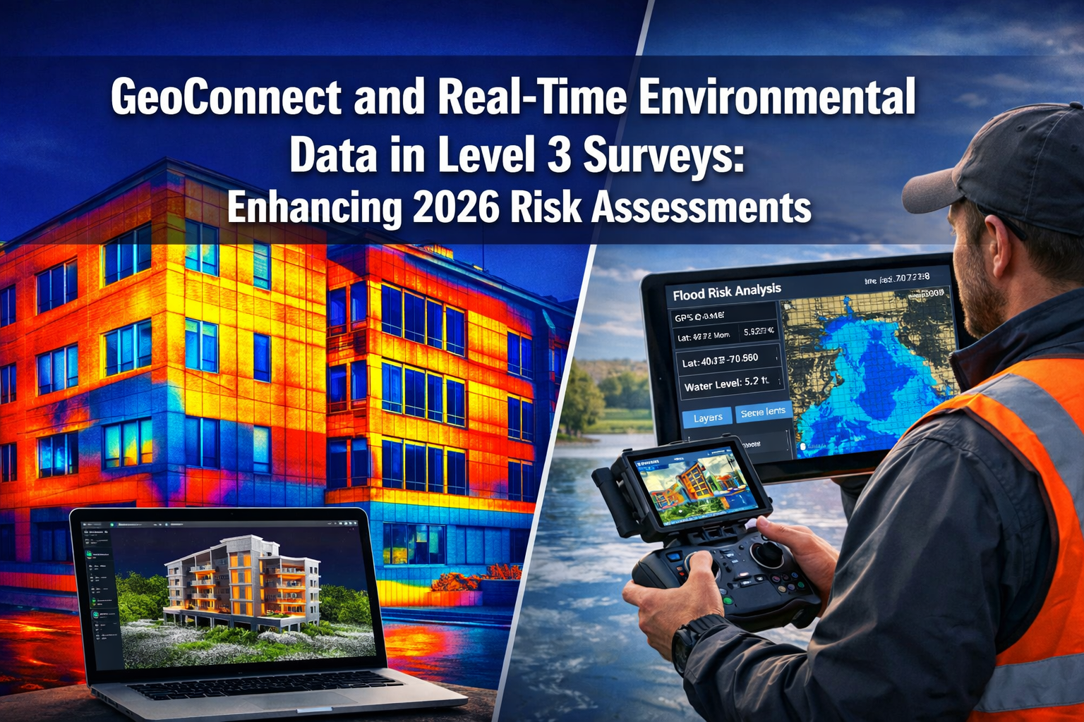
Property surveyors conducting comprehensive assessments in 2026 face a critical challenge: traditional survey methods can delay complex building evaluations by 3-6 weeks while waiting for environmental reports, flood data, and contamination assessments. This bottleneck becomes particularly acute for high-rise buildings, adapted homes, and properties in environmentally sensitive areas. The integration of GeoConnect and real-time environmental data in Level 3 surveys is revolutionizing how risk assessments are conducted, providing surveyors with instant access to critical information that once required weeks of research and multiple specialist consultations.
GeoConnect and Real-Time Environmental Data in Level 3 Surveys: Enhancing 2026 Risk Assessments represents a fundamental shift in building survey methodology. By aggregating flood risk data, soil contamination records, energy performance metrics, and thermal imaging analysis into a single platform, surveyors can now deliver more accurate, comprehensive assessments in significantly less time.
Key Takeaways
✅ Instant Data Access: GeoConnect platforms aggregate flood, contamination, and energy data in real-time, reducing survey delays by up to 70%
✅ Enhanced Risk Detection: Integrated thermal imaging and environmental sensors identify hidden issues that traditional visual inspections miss
✅ Comprehensive Reporting: Real-time data integration enables surveyors to provide more detailed risk assessments for complex properties
✅ Cost Efficiency: Upfront environmental data access reduces the need for multiple follow-up investigations and specialist consultations
✅ Regulatory Compliance: Automated data collection ensures surveys meet 2026 environmental and safety standards
Understanding GeoConnect Technology in Modern Building Surveys
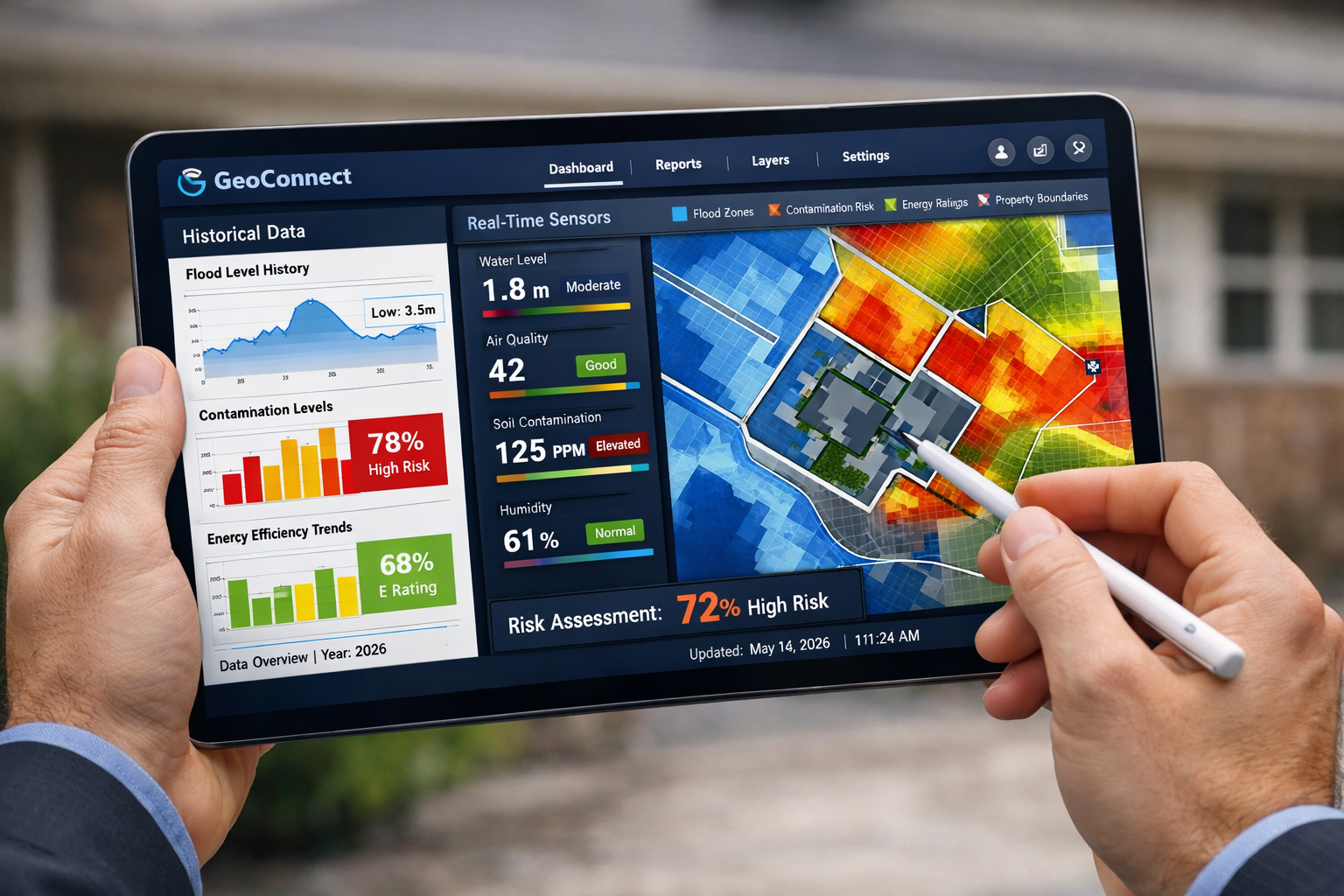
GeoConnect platforms represent the convergence of geospatial technology, artificial intelligence, and real-time environmental monitoring. These systems aggregate data from multiple authoritative sources—including Environment Agency flood maps, historical contamination records, local authority planning databases, and energy performance certificate registries—into a single, accessible interface.
For surveyors conducting Level 3 full building surveys, this technology addresses a longstanding challenge. Traditional survey methods required surveyors to manually request environmental reports, wait for responses from multiple agencies, and piece together fragmented information. This process often extended building survey timeframes significantly, particularly for properties with complex histories.
Core Components of GeoConnect Systems
Environmental Data Aggregation 🌍
GeoConnect platforms pull information from dozens of databases simultaneously, including:
- Flood risk zones (fluvial, pluvial, and coastal flooding)
- Historical contamination records from industrial sites
- Radon gas concentration maps
- Ground stability and subsidence risk data
- Protected species habitats and conservation areas
- Energy performance ratings and thermal efficiency baselines
Real-Time Sensor Integration 📡
Modern GeoConnect systems connect directly to IoT environmental sensors that provide live readings of:
- Indoor air quality and moisture levels
- Structural movement and settlement
- Temperature variations indicating insulation failures
- Water ingress detection in concealed spaces
AI-Powered Analysis 🤖
Machine learning algorithms analyze historical patterns and current data to predict potential issues. According to industry research, AI-powered sensors and drone technology are being implemented to provide real-time structural, environmental, and access data in building surveys, addressing gaps in traditional methods[1].
How GeoConnect and Real-Time Environmental Data Transform Level 3 Survey Risk Assessments
The integration of GeoConnect technology into Level 3 surveys fundamentally changes how surveyors approach risk assessment. Rather than identifying visible defects and recommending further investigation, surveyors can now provide immediate context about environmental risks that may not be visually apparent during inspection.
Flood Risk Assessment Integration
Traditional flood risk assessment required surveyors to note property location and recommend clients obtain separate flood reports. With GeoConnect integration, surveyors access:
- Precise flood zone mapping showing property boundaries relative to high-risk areas
- Historical flood event data including dates, depths, and durations of past flooding
- Climate projection models indicating how flood risk may evolve through 2050
- Surface water drainage capacity for the immediate area
This information allows surveyors to provide specific recommendations in their reports, such as whether flood-resistant construction measures are advisable or if certain basement conversions would be high-risk.
Contamination and Ground Condition Analysis
For properties on or near former industrial sites, GeoConnect platforms provide immediate access to:
| Data Type | Information Provided | Survey Impact |
|---|---|---|
| Historical Land Use | Previous industrial activities, manufacturing processes | Identifies potential soil contaminants |
| Contamination Records | Known pollutants, remediation history | Assesses health risks and development constraints |
| Ground Stability | Subsidence risk, mining activity, clay shrinkage | Evaluates foundation integrity concerns |
| Radon Levels | Background radiation measurements | Determines need for radon protection measures |
This upfront data is particularly valuable when assessing building materials that may have been affected by ground contamination or when identifying areas requiring further investigation.
Energy Performance and Thermal Efficiency Data
GeoConnect platforms integrate Energy Performance Certificate (EPC) data and thermal baseline information, enabling surveyors to:
- Compare current thermal performance against similar properties
- Identify discrepancies between expected and actual energy efficiency
- Highlight potential hidden insulation failures
- Estimate improvement costs with greater accuracy
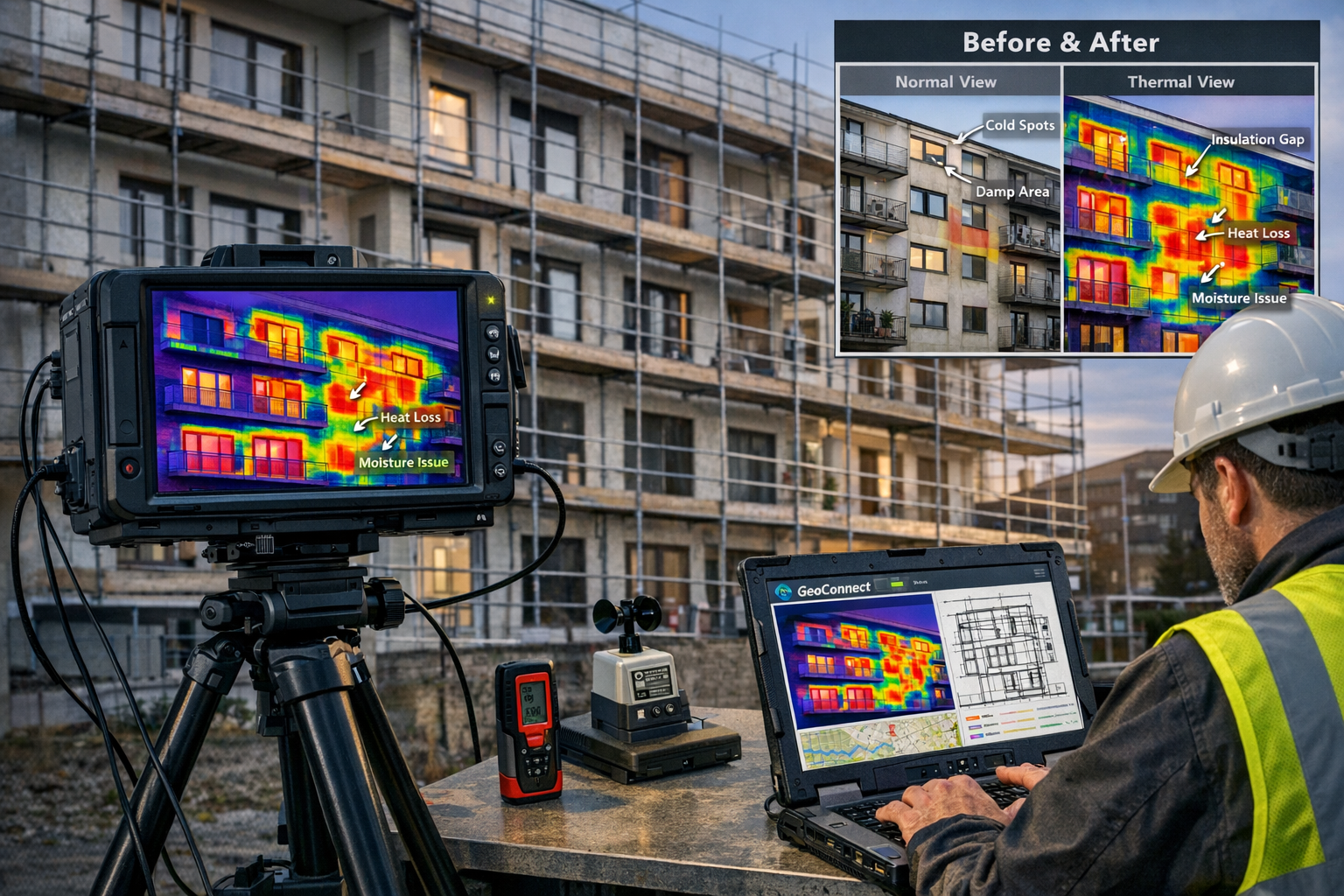
Case Studies: Integrated Thermal Imaging in Complex Property Assessments
High-Rise Apartment Building Assessment
A surveyor conducting a Level 3 survey on a 12-story apartment building in London utilized GeoConnect integration with thermal imaging drones. The GeoConnect platform immediately flagged:
- Flood risk: Property located 200 meters from a watercourse with moderate surface water flood risk
- Historical data: Building constructed in 1985 with known cladding issues in similar developments
- Energy baseline: EPC rating of D, below average for similar buildings
The surveyor deployed thermal imaging drones to inspect the building facade, which would have been impossible with traditional access methods. The thermal imaging revealed:
✓ Significant heat loss through window seals on floors 6-9
✓ Moisture intrusion behind cladding panels on the north elevation
✓ Inconsistent insulation installation in the roof space
By integrating GeoConnect environmental data with real-time thermal imaging, the surveyor identified £180,000 in potential remediation costs that would have been missed in a standard visual inspection. The comprehensive data allowed the buyer to renegotiate the purchase price and plan necessary improvements.
Adapted Home with Accessibility Features
A family purchasing an adapted property for a wheelchair user required assurance that environmental factors wouldn't compromise the specialized features. The surveyor used GeoConnect to access:
- Ground movement data showing moderate clay shrinkage risk
- Historical planning records revealing previous foundation underpinning
- Flood risk assessment indicating low probability but high consequence if flooding occurred
Integrated thermal imaging revealed that the ground-floor bedroom extension (critical for accessibility) had inadequate insulation and potential damp penetration. The GeoConnect platform's moisture risk modeling, combined with real-time humidity sensors, indicated that without remediation, the space would become unsuitable within 3-5 years.
The surveyor's report included specific recommendations:
- Install French drains around the extension perimeter
- Upgrade insulation to current building regulations standards
- Implement active moisture monitoring system
- Consider flood-resistant door thresholds despite low statistical risk
This level of detailed, data-driven analysis would have been impossible without the integration of GeoConnect and real-time environmental monitoring.
Period Property with Complex History
A Grade II listed building survey presented unique challenges due to its 200-year history and multiple alterations. GeoConnect data revealed:
- Property built on former marshland (high settlement risk)
- Located in conservation area with strict alteration restrictions
- Previous industrial use of adjacent plot (contamination concern)
- Radon affected area requiring protective measures
The surveyor combined this environmental data with thermal imaging to assess the building's condition. The thermal analysis identified:
🔍 Significant thermal bridging through solid brick walls
🔍 Heat loss through original single-glazed windows
🔍 Moisture patterns suggesting rising damp in north wall
🔍 Roof insulation gaps reducing overall thermal performance
By presenting integrated environmental and thermal data, the surveyor provided the client with a comprehensive understanding of both heritage constraints and practical improvement opportunities, enabling informed decision-making about this complex property purchase.
The Role of Geo Connect Asia 2026 in Advancing Survey Technology
The geospatial technology sector experienced significant advancement in early 2026. Geo Connect Asia 2026, held in Singapore in late March, brought together leaders in geospatial technology, AI, and digital construction[2]. The conference showcased emerging technologies that are now being integrated into building survey practices across the UK and internationally.
Key developments highlighted at the conference included:
Enhanced Data Integration Protocols 📊
New standards for combining geospatial data from multiple jurisdictions enable surveyors to access comprehensive environmental information regardless of property location.
AI-Driven Predictive Modeling 🎯
Machine learning algorithms that analyze historical building performance data alongside environmental factors to predict future maintenance requirements and risk evolution.
Real-Time Sensor Networks 🔌
IoT sensor deployments that provide continuous environmental monitoring, enabling surveyors to access long-term data trends rather than single-point-in-time measurements.
The conference also addressed upcoming developments at GID 2026, scheduled for Frankfurt on June 29-30, 2026, which will convene investors, asset managers, and policymakers focused on geospatial infrastructure[4]. These industry gatherings demonstrate the growing recognition of geospatial data's critical role in property assessment and risk management.
Implementing GeoConnect in Your Level 3 Survey Practice
For surveying professionals looking to integrate GeoConnect and real-time environmental data into their practice, several implementation considerations are essential:
Technology Infrastructure Requirements
Hardware Investments 💻
- Ruggedized tablets capable of displaying high-resolution geospatial data on-site
- Thermal imaging cameras with data export capabilities
- Drone equipment for aerial thermal surveys and facade inspection
- Portable environmental sensors for moisture, air quality, and temperature monitoring
Software Platforms 🖥️
- GeoConnect subscription services providing access to environmental databases
- Building Information Modeling (BIM) software for integrating geospatial and structural data
- Report generation tools that seamlessly incorporate real-time data visualizations
- Cloud storage solutions for managing large thermal imaging and geospatial datasets
Training and Competency Development
Surveyors must develop new competencies to effectively utilize integrated environmental data:
- Geospatial data interpretation: Understanding flood risk modeling, contamination assessment methodologies, and ground stability analysis
- Thermal imaging analysis: Interpreting thermal patterns to identify insulation failures, moisture intrusion, and structural defects
- Data integration skills: Combining multiple data sources into coherent risk assessments
- Technology operation: Proficient use of drones, sensors, and data collection equipment
Quality Assurance and Verification
While GeoConnect platforms provide extensive data, surveyors must maintain professional skepticism and verify critical findings:
✓ Cross-reference environmental data against multiple sources
✓ Validate thermal imaging findings with physical inspection where possible
✓ Consider temporal factors (seasonal variations, recent weather events)
✓ Document data sources and collection methodologies in survey reports
Regulatory Considerations and Professional Standards in 2026
The integration of technology into building surveys operates within evolving regulatory frameworks. In 2026, several key standards govern the use of environmental data and technology in property assessments:
Data Protection and Privacy
GeoConnect platforms must comply with UK GDPR requirements when collecting and storing property-specific environmental data. Surveyors should ensure:
- Client consent for data collection and storage
- Secure data transmission and storage protocols
- Clear data retention and deletion policies
- Transparency about third-party data sharing
Professional Indemnity Considerations
The use of advanced technology in surveys may affect professional indemnity insurance coverage. Surveyors should:
- Notify insurers of technology use in survey practice
- Maintain records of equipment calibration and maintenance
- Document training and competency in technology use
- Clearly state limitations of technology-based assessments in reports
Compliance with RICS Standards
The Royal Institution of Chartered Surveyors (RICS) continues to update guidance on technology use in building surveys. Key principles include:
- Technology should enhance, not replace, professional judgment
- Surveyors remain responsible for all report content regardless of data source
- Clear disclosure of methodology and data sources in reports
- Appropriate professional skepticism regarding automated data analysis
Benefits for Property Buyers and Stakeholders
The integration of GeoConnect and real-time environmental data delivers significant advantages for property buyers, particularly those purchasing complex or high-value properties:
Informed Decision-Making
Buyers receive comprehensive information about environmental risks that may not be immediately visible during viewings. This includes:
- Long-term flood risk projections considering climate change
- Historical contamination that may affect property use or value
- Energy efficiency opportunities and associated costs
- Structural risks related to ground conditions
Negotiation Leverage
Detailed environmental and thermal data provides objective evidence for price negotiations. When urgent or dangerous building issues are identified through integrated data analysis, buyers can request price reductions or require sellers to address problems before completion.
Future-Proofing Property Investments
Understanding environmental risks and energy performance enables buyers to:
- Plan necessary improvements with accurate cost estimates
- Assess long-term property viability considering climate projections
- Make informed decisions about insurance requirements
- Evaluate property suitability for intended use
Reduced Transaction Delays
By providing comprehensive environmental data upfront, GeoConnect integration reduces the need for multiple follow-up investigations. This streamlines the property purchase process and reduces the risk of transactions falling through due to unexpected environmental issues discovered late in the process.
Future Developments in Environmental Data Integration
The field of geospatial technology and environmental data integration continues to evolve rapidly. Several emerging trends will further enhance Level 3 survey capabilities in coming years:
Predictive Maintenance Modeling
Advanced AI algorithms will increasingly predict when building components are likely to fail based on environmental exposure, usage patterns, and material degradation rates. This will enable surveyors to provide more accurate maintenance forecasting in their reports.
Climate Change Adaptation Planning
GeoConnect platforms are incorporating long-term climate projections to assess how environmental risks will evolve over 30-50 year timeframes. This information helps buyers understand whether properties will remain viable investments as climate patterns change.
Automated Compliance Checking
Future systems will automatically assess whether properties comply with evolving environmental regulations, energy efficiency standards, and building safety requirements, flagging potential compliance issues in survey reports.
Blockchain-Verified Environmental Data
Emerging blockchain technologies may provide tamper-proof records of environmental assessments, remediation work, and building modifications, creating comprehensive property histories that enhance future survey accuracy.
Conclusion: Embracing Integrated Technology for Superior Risk Assessment
GeoConnect and Real-Time Environmental Data in Level 3 Surveys: Enhancing 2026 Risk Assessments represents more than technological advancement—it represents a fundamental improvement in how property risks are identified, analyzed, and communicated. By aggregating flood data, contamination records, energy performance metrics, and real-time sensor information, surveyors can deliver unprecedented levels of insight into property condition and environmental risks.
The case studies presented demonstrate the practical value of this integration: from identifying £180,000 in hidden remediation costs in high-rise buildings to ensuring adapted homes remain suitable for their critical accessibility functions. These real-world applications show how technology enhances professional judgment rather than replacing it.
For surveyors, the message is clear: embracing integrated environmental data and thermal imaging technology is no longer optional—it's essential for delivering the comprehensive, accurate assessments that clients expect in 2026. The investment in technology, training, and implementation processes pays dividends through enhanced report quality, reduced survey timescales, and improved client satisfaction.
For property buyers, particularly those considering complex properties or buildings in environmentally sensitive areas, insisting on surveys that incorporate GeoConnect and real-time environmental data provides significant advantages. The upfront investment in a comprehensive Level 3 building survey utilizing these technologies can prevent costly surprises and enable truly informed decision-making.
Next Steps for Implementation
For Surveying Professionals:
- Evaluate GeoConnect platform options and select providers aligned with your practice needs
- Invest in thermal imaging equipment and drone technology appropriate for your typical survey types
- Complete training programs in geospatial data interpretation and thermal imaging analysis
- Update report templates to effectively present integrated environmental data
- Review professional indemnity insurance coverage for technology-based assessments
For Property Buyers:
- When commissioning surveys, specifically request integration of environmental data and thermal imaging
- Ask surveyors about their GeoConnect platform access and technology capabilities
- Review the difference between Level 2 and Level 3 surveys to ensure appropriate survey level selection
- Ensure survey reports include clear visualization of environmental risks and thermal analysis findings
- Use integrated data to inform negotiation strategies and improvement planning
The convergence of geospatial technology, real-time environmental monitoring, and traditional surveying expertise creates unprecedented opportunities for accurate property risk assessment. As the industry continues to evolve, those who embrace these integrated approaches will deliver superior value to clients while advancing professional standards across the surveying sector.
References
[1] Technology For Upfront Property Understanding In Building Surveys Beyond Geoconnect To Holistic Risk Assessment – https://nottinghillsurveyors.com/blog/technology-for-upfront-property-understanding-in-building-surveys-beyond-geoconnect-to-holistic-risk-assessment
[2] Geo Connect Asia 2026 – https://highways.today/2026/03/28/geo-connect-asia-2026/
[3] Precision Or Nothing – https://www.xyht.com/magazine/precision-or-nothing/
[4] Gid 2026 29 30 June 2026 – https://www.geoconnexion.com/events/gid-2026-29-30-june-2026