

By June 2026, 73% of construction professionals use Building Information Modelling in their daily workflows — up from just 10% a decade ago [6]. For chartered surveyors, that shift is not a distant trend. It is the baseline expectation for every retrofit assessment, energy audit, and sustainability compliance report delivered this year.
The Chartered Surveyor Tech Stack for 2026 Retrofit Assessments: Drones, BIM and AI for Sustainability Compliance is no longer a forward-looking concept. It is a practical, client-facing toolkit that determines the speed, accuracy, and regulatory credibility of retrofit work across the UK. This guide breaks down each layer of that toolkit — from drone-based reality capture to AI-driven compliance checking — with a focus on RICS standards, regional practice, and measurable outcomes.
Key Takeaways
- Nearly 58% of surveying organisations now embed reality capture technologies such as drones and LiDAR into most or all projects [4].
- AI platforms integrated directly within BIM workflows can flag compliance issues in real time, reducing permit delays and costly redesigns [1].
- DroneDeploy's Progress AI tracks over 80 trade types with 95% accuracy, delivering site reports within two hours of data upload [7].
- Geospatial data combined with machine learning is accelerating environmental impact assessments for retrofit and renewable energy projects [8].
- Surveyors who combine drone surveys, BIM modelling, and AI analytics deliver faster, more defensible reports that meet tightening UK sustainability regulations.
Why the 2026 Retrofit Landscape Demands a New Tech Stack
The UK's drive toward net-zero has placed retrofit assessments at the centre of property practice. Minimum Energy Efficiency Standards, Future Homes Standard consultations, and tightening EPC requirements mean that a clipboard-and-camera survey is no longer sufficient for most commercial or residential retrofit commissions.
Three forces are converging simultaneously:
- Regulatory pressure: Stricter environmental regulations now require ecological and energy data that manual inspection cannot reliably capture [5].
- Client expectation: Property owners, developers, and housing associations expect quantified carbon savings, not qualitative commentary.
- Insurance and liability: Errors in retrofit specifications carry significant financial consequences, making data accuracy a professional risk management issue.
Against this backdrop, the Chartered Surveyor Tech Stack for 2026 Retrofit Assessments — combining drones, BIM, and AI — provides the accuracy, auditability, and speed that modern compliance demands.
"The integration of LiDAR, drone surveys, AI-powered analytics, and remote sensing are now essential for assessing environmental impacts and ensuring compliance with sustainability regulations." [5]
For surveyors working across diverse regions, from chartered surveyors in Surrey to chartered surveyors in Buckinghamshire, the practical challenge is integrating these tools into existing workflows without disrupting fee structures or project timelines.
Layer One: Drone Surveys and Reality Capture
What Drones Deliver That Traditional Surveys Cannot
Drones are now universally adopted among organisations using reality capture technologies [4]. Their value in retrofit assessment is specific and measurable:
| Capability | Traditional Survey | Drone-Enabled Survey |
|---|---|---|
| Roof inspection | Ladder access required | Full coverage, no access risk |
| Thermal imaging | Spot readings only | Whole-facade heat-loss mapping |
| Point-cloud data | Not available | LiDAR-accurate 3D models |
| Time on site | Half to full day | 1-2 hours for most properties |
| Repeatability | Variable | Consistent, georeferenced |
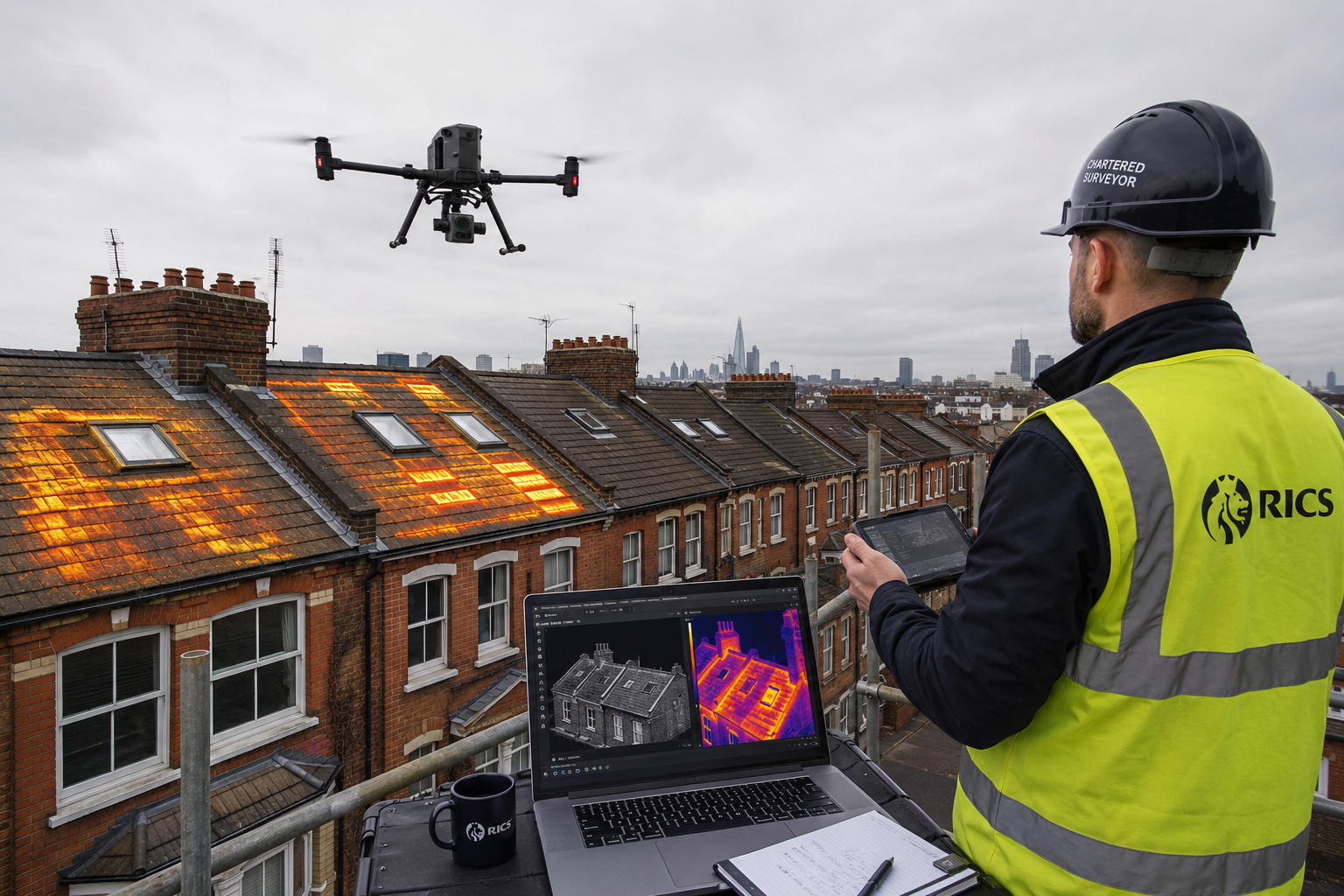
A premium drone survey captures thermal anomalies, structural defects, and dimensional data in a single mobilisation. For retrofit work, this means identifying insulation failures, cold bridges, and air-leakage points before any specification is written.
LiDAR, Photogrammetry, and Point-Cloud Processing
LiDAR-equipped drones generate dense point clouds that feed directly into BIM platforms. By March 2026, AI features in platforms such as Pix4D, DroneDeploy, and Bentley iTwin Capture have enhanced these processes significantly, enabling automatic feature extraction, classification, point-cloud cleanup, and seamless BIM integration [2].
This matters for retrofit assessments because:
- Automatic feature extraction identifies window frames, roof elements, and wall junctions without manual digitising.
- Point-cloud cleanup removes noise data, producing cleaner models for U-value and thermal bridging calculations.
- BIM integration means the captured geometry becomes the foundation for energy modelling, not a separate deliverable.
For complex properties — listed buildings, mixed-use blocks, or estates with poor access — drone-based reality capture reduces both survey time and the risk of missed defects. Surveyors operating in areas like East London or South West London regularly encounter dense urban stock where roof and facade access is genuinely hazardous without aerial technology.
Layer Two: BIM Integration for Energy and Carbon Modelling
BIM as the Central Data Environment
Building Information Modelling has moved from a design-phase tool to a whole-lifecycle platform. For retrofit assessments, BIM serves as the central data environment where geometry, material properties, energy performance data, and compliance records coexist.
As of 2026, 73% of construction professionals use BIM daily [6]. For chartered surveyors, this adoption rate means clients increasingly expect BIM-ready outputs — not just PDF reports.
Key BIM applications in retrofit assessment include:
- As-built modelling from drone and LiDAR data, establishing accurate geometry for energy calculations.
- Material and U-value libraries that allow rapid specification of insulation, glazing, and air-tightness measures.
- Clash detection identifying conflicts between proposed retrofit measures and existing structural or service elements.
- 4D sequencing showing the order of retrofit works to minimise disruption and cost.
For community housing projects and large residential blocks, BIM enables surveyors to model multiple retrofit scenarios simultaneously, comparing carbon savings, costs, and payback periods before a single specification is issued.
AI-Powered Compliance Checking Within BIM
The most significant development in the Chartered Surveyor Tech Stack for 2026 Retrofit Assessments is the arrival of AI-driven compliance platforms embedded directly within BIM workflows.
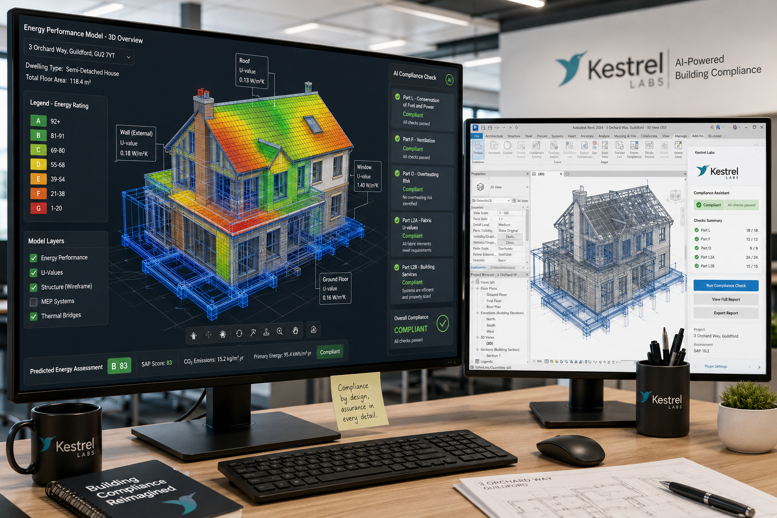
In June 2026, Kestrel Labs launched the first AI-driven compliance platform embedded within Autodesk Revit, integrating jurisdiction-specific code requirements and enabling real-time compliance checks during the design phase [1]. Backed by a data agreement with the International Code Council, this platform aims to reduce permit delays by catching compliance issues before they reach the planning or building control stage.
What this means in practice:
- Surveyors modelling a wall insulation upgrade receive an instant flag if the proposed specification fails Part L thermal performance thresholds.
- Proposed window replacements are checked against conservation area restrictions automatically.
- Carbon emission reduction targets are tracked against the model in real time, not retrospectively.
Major platforms including Autodesk Construction Cloud, Procore, and Trimble have also incorporated AI functionalities covering generative design, predictive risk assessment, and AI-assisted project management [3]. For retrofit work, predictive risk assessment is particularly valuable — identifying properties where condensation risk, structural movement, or service conflicts are likely before works commence.
A measured building survey provides the dimensional accuracy that BIM energy models depend on. Without reliable as-built data, even the most sophisticated AI compliance tool will produce unreliable outputs.
Layer Three: AI Analytics for Sustainability Compliance
From Data Capture to Compliance Evidence
Drones and BIM generate large volumes of data. AI analytics transforms that data into the compliance evidence that regulators, lenders, and clients require.
In January 2026, SLR Consulting began using Bluesky International's geospatial data to advance machine learning applications in sustainability and renewable energy projects, enhancing the speed, accuracy, and scalability of environmental analyses [8]. This model — combining high-resolution geospatial inputs with machine learning outputs — is directly applicable to retrofit assessment at scale.
For chartered surveyors, AI analytics delivers value across several compliance tasks:
| Task | Traditional Approach | AI-Enhanced Approach |
|---|---|---|
| EPC rating calculation | Manual data entry, SAP software | Automated from BIM model data |
| Thermal bridging analysis | Specialist calculation, slow | AI pattern recognition from thermal imagery |
| Carbon baseline assessment | Spreadsheet modelling | Real-time model from captured data |
| Retrofit prioritisation | Surveyor judgement | AI-ranked by carbon impact and cost |
| Compliance reporting | Manual document assembly | Auto-generated from BIM/AI outputs |
Progress Monitoring and Verification
DroneDeploy's Progress AI, launched in July 2025, tracks over 80 trade types with 95% accuracy and delivers reports within two hours of data upload [7]. For retrofit programmes covering multiple properties — such as a housing association's planned improvement works — this capability allows surveyors to verify that installed measures match the specification without repeated site visits.
This has direct implications for building survey practice. Post-works verification — confirming that insulation has been installed to the correct depth, that air-tightness measures are complete, and that thermal bridging details have been executed correctly — can now be conducted remotely with AI-assisted analysis of drone imagery.
Geospatial Data and Environmental Impact Assessment
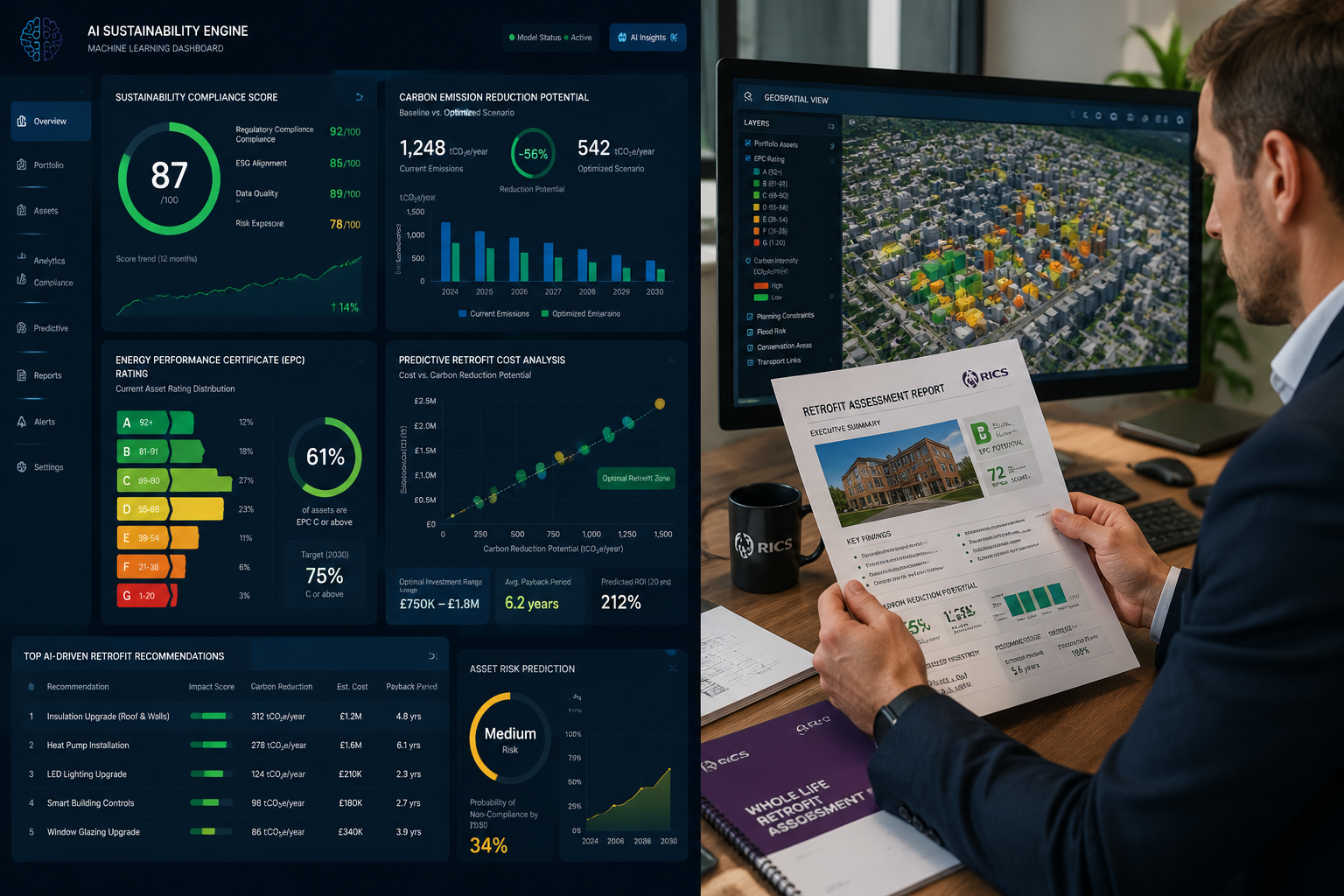
Stricter environmental regulations by 2026 have made ecological data capture a standard part of surveying practice [5]. AI-powered analytics applied to geospatial datasets enable surveyors to:
- Assess flood risk at property level using high-resolution terrain models.
- Evaluate solar potential for photovoltaic installations as part of retrofit packages.
- Identify biodiversity net gain obligations triggered by retrofit works affecting external fabric.
- Model urban heat island effects relevant to overheating risk assessments under Part O.
For surveyors working in areas such as Hampshire or Sussex, where rural and semi-rural properties present specific environmental sensitivities, this geospatial capability is increasingly essential for compliant retrofit specifications.
Building the Practical Tech Stack: Tools, Costs, and RICS Alignment
Recommended Tool Categories for 2026
A practical Chartered Surveyor Tech Stack for 2026 Retrofit Assessments does not require every available technology. The following framework covers the core layers:
Reality Capture
- Drone platform: DJI Matrice or Mavic 3 Enterprise with thermal and RGB cameras
- LiDAR scanner: Leica BLK360 or FARO Focus for interior capture
- Photogrammetry software: Pix4D, DroneDeploy, or Bentley iTwin Capture
BIM and Energy Modelling
- BIM platform: Autodesk Revit or ArchiCAD with IFC export capability
- Energy modelling: IES VE, DesignBuilder, or Integrated Environmental Solutions
- Compliance checking: Kestrel Labs BIM-native compliance plugin [1]
AI Analytics and Reporting
- Progress monitoring: DroneDeploy Progress AI [7]
- Geospatial analytics: Bluesky International data feeds with ML integration [8]
- Report generation: AI-assisted document tools integrated with BIM outputs
RICS Standards and Professional Obligations
The RICS Home Survey Standard and the RICS Building Surveys and Technical Due Diligence guidance both emphasise the need for proportionate, evidence-based reporting. The tech stack described above supports these obligations by:
- Improving evidence quality: Thermal imagery, point clouds, and BIM models provide objective, reproducible data.
- Reducing omission risk: AI-assisted analysis flags issues that visual inspection may miss.
- Supporting professional indemnity: Documented, data-rich assessments are more defensible in dispute.
For surveyors considering how technology investment affects their service offering, a full Level 3 building survey enhanced with drone and thermal data provides clients with a significantly more comprehensive picture of retrofit potential than a standard visual inspection.
Cost Considerations and Return on Investment
Technology investment carries upfront costs, but the return is measurable:
- Reduced site time: Drone surveys cut physical access requirements by 40-60% on complex properties.
- Fewer return visits: Comprehensive data capture in a single mobilisation reduces abortive travel.
- Higher-value outputs: BIM-ready deliverables command premium fees compared to standard survey reports.
- Reduced error risk: AI compliance checking reduces the likelihood of specification errors that generate professional indemnity claims.
For smaller practices, cloud-based subscriptions to platforms like DroneDeploy and Autodesk Construction Cloud reduce capital expenditure while providing access to enterprise-grade AI tools.
Conclusion
The Chartered Surveyor Tech Stack for 2026 Retrofit Assessments — integrating drones, BIM, and AI for sustainability compliance — is not an optional upgrade. It is the operational standard that RICS-regulated practice, client expectation, and UK regulatory requirements now demand.
Actionable next steps for surveying practices:
- Audit your current toolkit against the three layers outlined above: reality capture, BIM integration, and AI analytics. Identify the gaps that carry the highest risk to report quality.
- Invest in drone capability first — either in-house or through a specialist subcontractor — as thermal and LiDAR data underpins every subsequent layer of analysis.
- Adopt a BIM platform with AI compliance integration to reduce the manual burden of checking retrofit specifications against Part L, Part O, and local planning requirements.
- Align reporting outputs with RICS standards, ensuring that AI-generated data is interpreted and presented by a qualified professional, not delivered raw to clients.
- Train your team on the specific tools in your stack. Technology without competent operators does not improve report quality.
The surveyors who build this capability now — across urban practices in Camden and regional offices serving Buckinghamshire or Surrey — will be positioned to handle the volume and complexity of retrofit work that UK net-zero targets will generate over the next decade.
References
[1] Kestrel Labs Launches Bim Native Compliance Platform – kestrellabs.com
[2] Ai Surveying Photogrammetry 2026 – pdpspectra.com
[3] Ai Construction Bim 2026 – pdpspectra.com
[4] 2026 Field Solutions Reality Capture Tech Specialty Report – builtworlds.com
[5] Sustainability In Surveying Using Tech To Assess Environmental Impacts And Regulations – canterburysurveyors.com
[6] Bim Integration For Land Surveyors Enhancing Construction Efficiency In 2026 – kingstonsurveyors.com
[7] Dronedeploy – contractortoolstack.com
[8] Slr Consulting Harnesses Bluesky Internationals Geospatial Data To Advance Machine Learning For Sustainability And Renewable Energy Projects – bluesky-world.com