Boundary disputes cost English and Welsh property owners an estimated £15,000 to over £100,000 in legal fees when cases reach the courts — yet the vast majority of these conflicts involve land lines that differ by less than a metre. In 2026, a growing body of updated RICS guidance, new mediation frameworks, and GPS-driven survey technology means that property owners and their advisers have more powerful, cost-effective tools than ever before. This article examines how Boundary Dispute Resolutions 2026: Chartered Surveyor Strategies Beyond Party Wall Act Using RICS Mediation Protocols are reshaping the way these conflicts are handled — particularly in cases that fall entirely outside the scope of the Party Wall etc. Act 1996.
Key Takeaways
- Most boundary disputes do not fall under the Party Wall Act and require a separate resolution strategy led by a chartered surveyor.
- RICS launched the Boundary Disputes Mediation Service (BDMS) in October 2024, providing a structured, cost-effective alternative to litigation.
- GPS total station surveys and expert witness reports now provide courts and mediators with precise, defensible boundary evidence.
- RICS ACRE Mediation protocols updated in 2026 offer analytical, commercial, and restorative frameworks tailored to property disputes.
- Early professional intervention dramatically reduces costs and preserves neighbour relationships compared with litigation.
Why the Party Wall Act Is Not the Answer for Most Boundary Disputes
The Party Wall etc. Act 1996 is a frequently misunderstood piece of legislation. It governs very specific situations: works to a shared wall, excavations near a neighbouring building, and new walls on the line of junction. What it does not do is resolve disagreements about where a boundary actually sits. If a neighbour erects a fence two metres inside what the other party believes is their land, the Party Wall Act is simply the wrong tool. Understanding this distinction is the first critical step in any effective resolution strategy.
For a detailed breakdown of when the Act does and does not apply, the party wall rights guide offers a useful starting point. Similarly, property owners should be aware of the consequences of ignoring the Party Wall Act when it does apply — but equally, they must recognise when a boundary conflict demands a different legal and professional framework entirely.
The Legal Distinction Between Party Wall and Boundary Matters
| Issue Type | Governed By | Professional Lead |
|---|---|---|
| Works to shared wall | Party Wall etc. Act 1996 | Party Wall Surveyor |
| Excavation near neighbour | Party Wall etc. Act 1996 | Party Wall Surveyor |
| Fence/wall position dispute | Land Registration Act 2002 / Common Law | Boundary Expert / Chartered Surveyor |
| Encroachment onto land | Common Law / Land Registry | Chartered Surveyor + Solicitor |
| Title plan ambiguity | Land Registration Act 2002 | Chartered Surveyor + Conveyancer |
When a dispute concerns the actual position of a legal boundary rather than works affecting a shared structure, the resolution pathway involves title deeds, historical mapping, physical survey evidence, and — increasingly — RICS-accredited mediation.
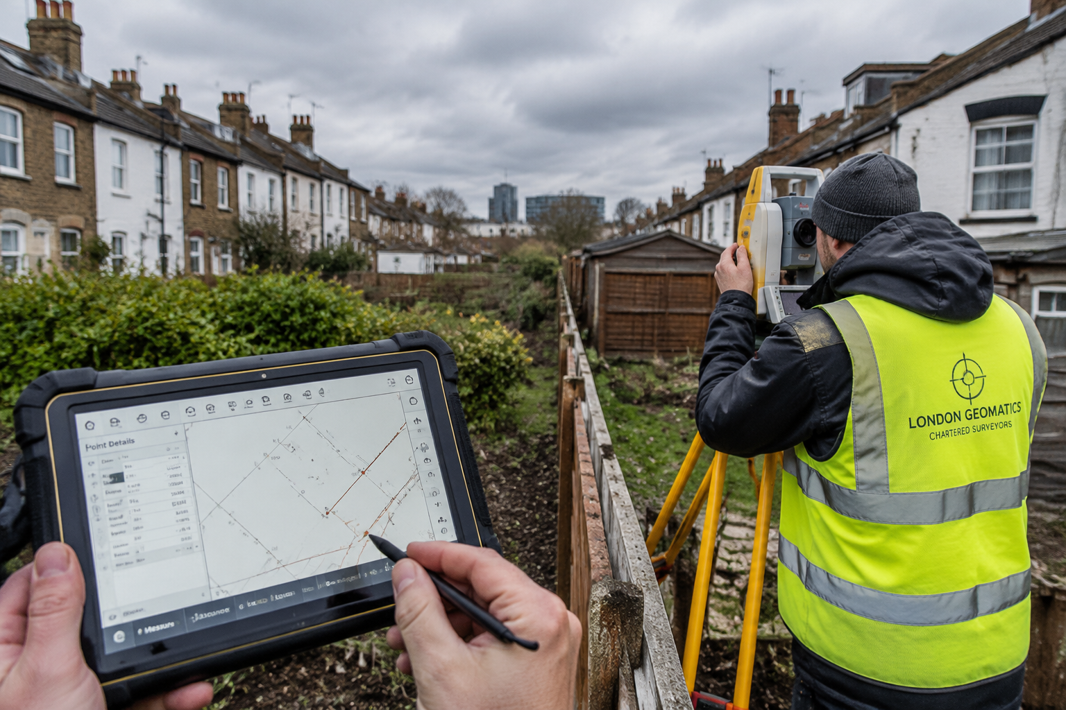
GPS Surveying Technology and Expert Witness Reports in 2026
One of the most significant developments in Boundary Dispute Resolutions 2026 is the widespread adoption of GPS total station technology and drone-assisted topographic surveys. These tools allow chartered surveyors to plot boundary positions with sub-centimetre accuracy, producing evidence that is both technically robust and readily understood by mediators, judges, and property owners alike [7].
How GPS and Topographic Surveys Establish Boundaries
A topographic survey conducted by a chartered surveyor will typically:
- Measure physical features — fences, walls, hedges, and ditches — against Ordnance Survey data
- Cross-reference title plan dimensions from HM Land Registry with actual on-the-ground measurements
- Identify discrepancies between the general boundary shown on the title plan and the physical boundary features
- Produce scaled drawings that can be submitted as evidence in mediation or court proceedings
RICS guidance is clear that title plans registered at HM Land Registry show only "general boundaries" and are not precise legal boundary definitions [10]. This is a point that surprises many property owners and is frequently at the root of disputes. The red line on a Land Registry title plan is indicative, not definitive.
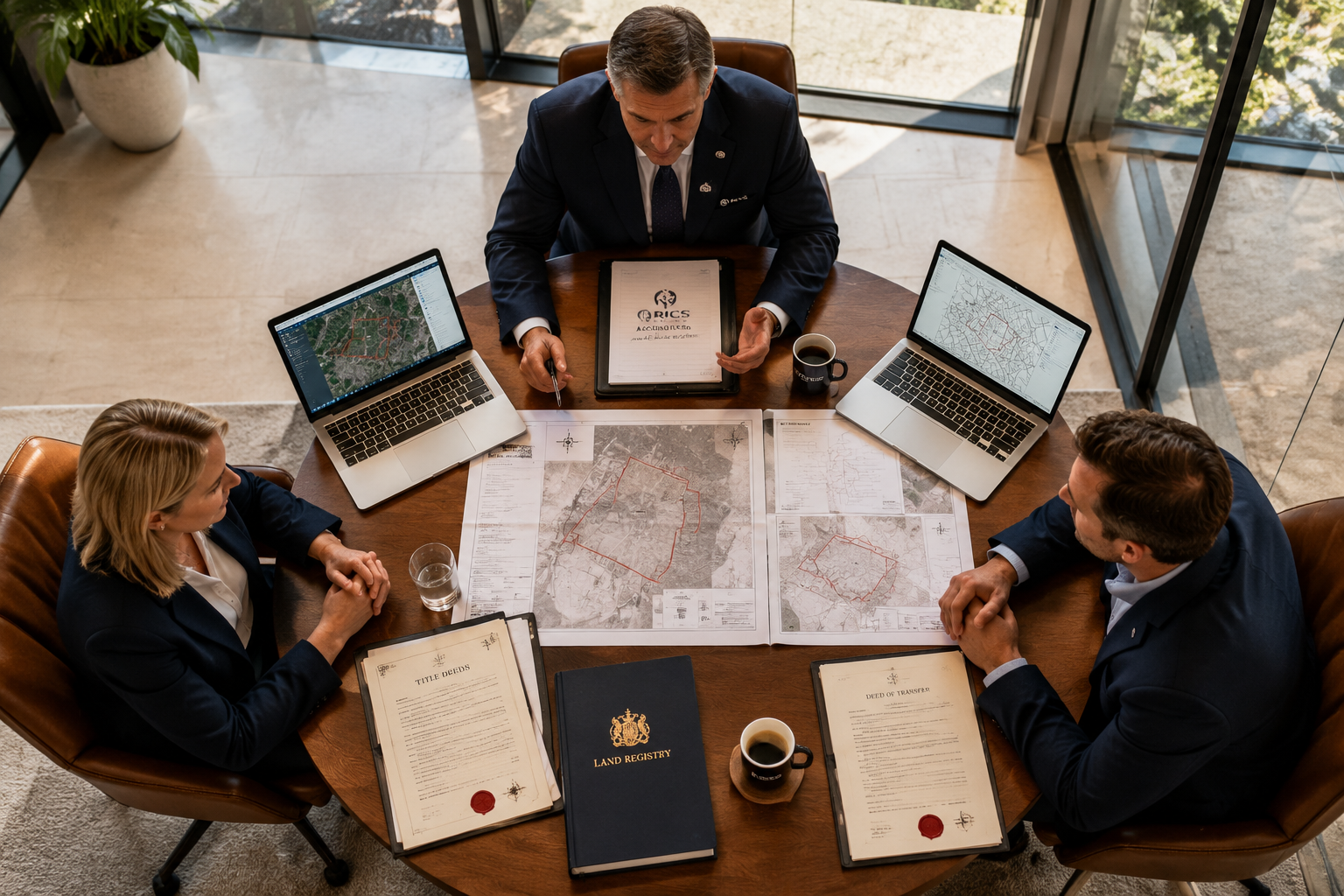
The Expert Witness Report
Where a boundary dispute proceeds to formal dispute resolution — whether mediation or litigation — a chartered surveyor may be instructed to prepare an expert witness report. RICS has established specific standards for surveyors acting in this capacity, requiring them to maintain impartiality, disclose conflicts of interest, and present evidence that assists the decision-maker rather than advocates for either party [4].
An expert witness report in a boundary dispute will typically include:
- A site inspection record with photographic evidence
- Analysis of title deeds, conveyance plans, and historical OS maps
- GPS survey data overlaid on current title plans
- An opinion on the most probable legal boundary position
- A commentary on any physical features that support or contradict that opinion
"The weight of a boundary expert's report in mediation or court proceedings depends entirely on the rigour of the underlying survey methodology and the surveyor's demonstrable impartiality."
Understanding the average cost of a boundary dispute is also essential context: investing in a thorough expert survey early in the process is almost always cheaper than the legal costs that accumulate once proceedings begin.
Boundary Dispute Resolutions 2026: Chartered Surveyor Strategies Beyond Party Wall Act Using RICS Mediation Protocols
The most significant institutional development in this field over the past two years has been the formalisation of RICS-led mediation pathways specifically designed for boundary disputes. These protocols represent a structured, professionally governed alternative to both informal negotiation and full litigation.
The Boundary Disputes Mediation Service (BDMS)
Launched in October 2024, the Boundary Disputes Mediation Service (BDMS) is a joint initiative between RICS and the Property Litigation Association, with support from the Civil Justice Council [1]. The BDMS provides:
- A structured mediation process led by a trained, impartial mediator
- The ability for parties to retain control over the outcome rather than having a decision imposed by a court
- A confidential setting that protects both parties from public disclosure
- Sessions conducted face-to-face or online, depending on the parties' agreement
- Costs that are a fraction of litigation expenses
The BDMS is particularly well-suited to disputes where both parties have some legitimate basis for their position — for example, where a title plan is ambiguous or where physical boundary features have shifted over time, such as after storm damage [8].
ACRE Mediation: The 2026 Updated Framework
Complementing the BDMS is the ACRE Mediation Service — Analytical, Commercial, Restorative, and Expert — which was updated in 2026 [2]. ACRE mediation is designed for more complex property and construction disputes and brings a four-dimensional approach:
- Analytical: The mediator examines the legal and factual merits of each party's position
- Commercial: Practical, financially viable solutions are explored alongside legal rights
- Restorative: The process actively works to preserve or repair the relationship between parties
- Expert: Sector-specific knowledge from the mediator adds technical depth to the process
This framework is particularly valuable in boundary disputes that have a commercial dimension — for example, where the disputed strip of land affects a development project, a right of way, or a property sale.
RICS Alternative Dispute Resolution Methods
Beyond the BDMS and ACRE, RICS offers a full spectrum of Alternative Dispute Resolution (ADR) methods through its Dispute Resolution Service (DRS) [5][9]:
| ADR Method | Best Suited For | Binding? |
|---|---|---|
| Mediation (BDMS/ACRE) | Neighbour disputes, title ambiguity | No (unless agreed) |
| Expert Determination | Technical boundary questions | Yes |
| Adjudication | Construction-related boundary issues | Temporarily binding |
| Arbitration | Complex, high-value disputes | Yes |
The choice between these methods depends on the complexity of the dispute, the commercial stakes involved, and whether the parties require a binding decision or prefer a negotiated settlement. RICS dispute resolution standards provide clear guidance for professionals navigating these choices [4].
For property owners in London and the surrounding areas, chartered surveyors in London with RICS accreditation are well-placed to advise on the most appropriate pathway from the outset.
A Step-by-Step Strategy for Non-PWA Boundary Disputes in 2026
Effective resolution of a boundary dispute that falls outside the Party Wall Act requires a clear, sequenced approach. The following strategy reflects current best practice under updated RICS guidance.
Step 1: Gather All Documentary Evidence
Before engaging any professional, both parties should compile:
- HM Land Registry title register and title plan for both properties
- Original conveyance documents (often more detailed than modern title plans)
- Historical Ordnance Survey maps — the 1:1250 and 1:2500 series are particularly useful
- Photographs showing the current state of boundary features
- Any correspondence with the neighbour about the boundary
Step 2: Commission a Chartered Surveyor's Boundary Survey
A RICS-accredited chartered surveyor should be instructed to carry out a measured boundary survey using GPS total station equipment. This survey will produce a scaled plan showing the relationship between the physical boundary features and the title plan [7]. The surveyor may also review historical deeds and maps to identify the original boundary intention.
An RICS building survey can sometimes reveal boundary-related issues that were not apparent at the time of purchase, making early survey investment doubly valuable.
Step 3: Attempt Direct Negotiation with Survey Evidence
Armed with a professional survey, many disputes can be resolved through direct negotiation. The survey provides an objective basis for discussion and removes some of the emotional charge from the conversation. A chartered surveyor can attend this meeting as a technical adviser.
Step 4: Refer to RICS Mediation
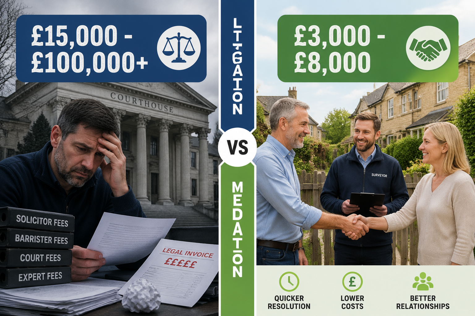
If direct negotiation fails, the BDMS or ACRE mediation service should be the next step — not litigation. The RICS Consumer Mediation Scheme also provides accessible support for residential property owners who need sector-specific guidance [6]. Mediation typically costs between £3,000 and £8,000 in total for both parties, compared with legal costs that can exceed £50,000 in contested boundary litigation.
Step 5: Expert Determination or Arbitration
Where mediation does not produce a resolution, expert determination by a RICS-appointed boundary expert provides a binding decision based on the technical evidence. This avoids the full costs and delays of court proceedings while still producing a definitive outcome [5].
Step 6: First-Tier Tribunal or Court (Last Resort)
Litigation through the First-Tier Tribunal (Property Chamber) or the County Court should be treated as a genuine last resort. Courts are increasingly expecting parties to have attempted ADR before issuing proceedings, and failure to do so can result in adverse cost orders regardless of the outcome on the merits.
Practical Considerations for Property Owners and Surveyors
Preserving Physical Evidence
Physical boundary features — fences, walls, hedges, and ditches — can be altered, removed, or damaged during a dispute. RICS guidance strongly recommends that property owners document the current state of all boundary features with dated photographs and measurements before any works take place [8]. This evidence can be critical in mediation or court proceedings.
The Role of the Agreed Surveyor
In some boundary disputes that overlap with party wall matters, an agreed surveyor can serve both parties simultaneously, reducing costs and streamlining the process. However, this arrangement requires genuine agreement and is only appropriate where the conflict is not deeply adversarial.
Costs and Funding
The cost of a party wall agreement is often cited as a benchmark for dispute resolution costs, but boundary disputes that go to litigation can be significantly more expensive. Legal aid is not available for most boundary disputes, making cost-effective ADR routes not just preferable but often essential.
Property owners should also consider whether their home insurance policy includes legal expenses cover for boundary disputes — a point worth checking before incurring professional fees. For more on what home insurance typically covers, see what is covered under home insurance.
When to Involve a Solicitor
A chartered surveyor handles the technical and evidential aspects of a boundary dispute. A solicitor handles the legal aspects — title interpretation, formal correspondence, and court proceedings if necessary. The most effective approach in 2026 combines both professionals working in parallel, with the surveyor's expert report underpinning the solicitor's legal strategy.
Conclusion
Boundary Dispute Resolutions 2026: Chartered Surveyor Strategies Beyond Party Wall Act Using RICS Mediation Protocols represent a mature, evidence-based approach to one of the most common and costly property conflicts in England and Wales. The key shift in 2026 is the availability of structured, professionally governed mediation pathways — particularly the BDMS and ACRE frameworks — that sit alongside GPS survey technology and expert witness standards to give property owners real alternatives to expensive and damaging litigation.
Actionable next steps for property owners and professionals:
- Commission a GPS boundary survey from a RICS-accredited chartered surveyor at the earliest sign of dispute
- Gather all documentary evidence — title plans, conveyances, and historical maps — before any professional meeting
- Refer to the RICS Boundary Disputes Mediation Service before considering litigation
- Explore ACRE mediation for disputes with a commercial or development dimension
- Treat court proceedings as a genuine last resort, not a first response
For those in London and the Home Counties, working with chartered surveyors in Richmond, chartered surveyors in Camden, or other locally based RICS professionals ensures that survey evidence is gathered with knowledge of local title register patterns and planning history. Early, expert intervention remains the single most effective strategy for resolving boundary disputes quickly, cost-effectively, and with neighbour relationships intact.
References
[1] Boundary Disputes Mediation Service – https://www.rics.org/dispute-resolution-service/drs-services/consumer-disputes/boundary-disputes-mediation-service?utm_source=openai
[2] Acre Mediation – https://www.rics.org/dispute-resolution-service/drs-services/mediation-services/acre-mediation?utm_source=openai
[3] Mediation Services – https://www.rics.org/dispute-resolution-service/drs-services/mediation-services?utm_source=openai
[4] Dispute Resolution Standards – https://www.rics.org/profession-standards/rics-standards-and-guidance/sector-standards/dispute-resolution-standards?utm_source=openai
[5] Alternative Dispute Resolution – https://www.rics.org/dispute-resolution-service/alternative-dispute-resolution?utm_source=openai
[6] Consumer Mediation Scheme – https://www.rics.org/dispute-resolution-service/drs-services/consumer-disputes/consumer-mediation-scheme?utm_source=openai
[7] Topographic Surveys And Boundary Disputes How To Establish Your Propertys Boundaries – https://www.rics.org/consumer-guides/topographic-surveys-and-boundary-disputes-how-to-establish-your-propertys-boundaries?utm_source=openai
[8] Reinstate Boundary Weather Damage – https://www.rics.org/consumer-guides/reinstate-boundary-weather-damage?utm_source=openai
[9] Dispute Resolution Service – https://www.rics.org/dispute-resolution-service?utm_source=openai
[10] Boundary Disputes England Wales – https://www.rics.org/consumer-guides/boundary-disputes-england-wales?utm_source=openai