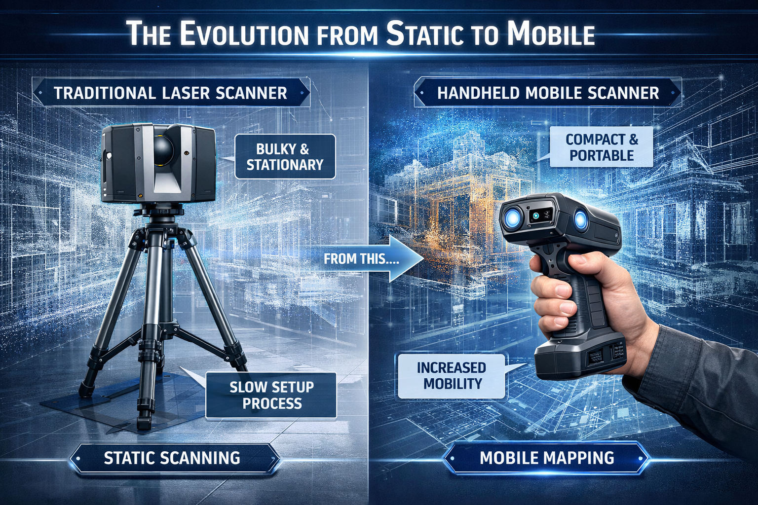
The surveying profession stands at a technological crossroads in 2026. While traditional tripod-mounted laser scanners have served the industry well for decades, they demand significant setup time, multiple scan positions, and extensive fieldwork hours to capture comprehensive site data. Enter 3D laser scanning and mobile mapping: creating digital replicas without bulky equipment—a revolutionary approach that's transforming how surveyors, architects, and construction professionals capture spatial information. Modern handheld and vehicle-mounted systems now deliver detailed 3D models in a fraction of the time, fundamentally changing project timelines and cost structures.
The shift from static to mobile scanning represents more than incremental improvement. It's a complete reimagining of the surveying workflow, where professionals can walk through spaces with lightweight devices and generate accurate point clouds in real-time, eliminating the tedious process of setting up heavy equipment at dozens of positions throughout a site.
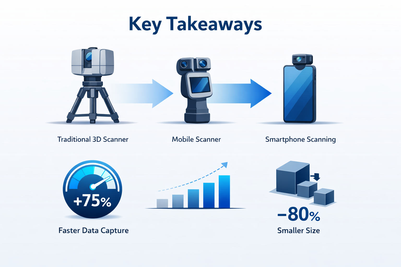
Key Takeaways
✅ Mobile laser scanning systems capture data 10x faster than traditional static scanners, achieving 100,000–150,000 square feet per day compared to 10,000–15,000 square feet with conventional methods[3]
✅ Field costs drop by 50–70% when using mobile LiDAR technology, though data processing may require additional modeling time due to increased point cloud density[3]
✅ SLAM technology enables GPS-free scanning in underground tunnels, dense urban environments, and disaster areas where traditional positioning systems fail[1]
✅ The mobile laser scanning market is experiencing robust 12% annual growth, driven by construction, mining, and telecommunications infrastructure demands[4]
✅ Modern mobile systems achieve 15–20mm real-world accuracy, meeting industry standards like BOMA 2026 for rentable area calculations while dramatically reducing project timelines[3]
The Evolution from Static to Mobile: Understanding 3D Laser Scanning and Mobile Mapping Without Bulky Equipment
Traditional Surveying Challenges
For decades, surveyors relied on terrestrial laser scanners (TLS)—precision instruments mounted on sturdy tripods that capture millions of points per second with exceptional accuracy. While these systems deliver survey-grade precision of approximately 1.9mm[3], they come with significant operational constraints:
- Extensive setup requirements: Each scan position requires careful leveling, positioning, and equipment stabilization
- Limited coverage per setup: A single static position captures only what's visible from that vantage point
- Time-intensive workflows: Large facilities require dozens or hundreds of individual scan positions
- Heavy equipment: Professional TLS systems with accessories can weigh 20-30 pounds or more
- Transportation challenges: Multiple cases of equipment, batteries, and accessories
A typical commercial building survey using traditional methods might require a team to spend several days on-site, methodically moving equipment from position to position, ensuring overlap between scans, and managing extensive data registration processes.
The Mobile Mapping Revolution
The landscape changed dramatically with the introduction of SLAM-based mobile mapping systems. SLAM (Simultaneous Localization and Mapping) technology enables devices to build maps of unknown environments while simultaneously tracking their own position within those spaces[1]. This breakthrough eliminated the need for fixed scan positions, allowing surveyors to simply walk through spaces while capturing comprehensive 3D data.
Modern flagship systems like the NavVis VLX 3 and Leica RTC360 represent the maturation of this technology[3], offering:
🚀 Continuous data capture while moving through environments
📱 Handheld portability that eliminates setup time
🎯 Real-time visualization of captured point clouds
🔋 Extended battery life for all-day scanning sessions
🌐 GPS-independent operation for indoor and underground work
The practical implications are transformative. What once required a full day of fieldwork with static scanning can now be accomplished in under an hour with mobile systems, as detailed in our building survey services.
Accuracy Considerations: Real-World Performance
A critical question for surveyors evaluating mobile systems centers on accuracy. While manufacturers often cite impressive specifications, real-world performance requires careful examination.
Static TLS systems deliver exceptional precision:
- Survey-grade accuracy: 1.9mm[3]
- Minimal drift over distance
- Consistent performance across scan sessions
- Ideal for applications requiring maximum precision
Mobile LiDAR systems achieve practical accuracy:
- Real-world accuracy: 15–20mm[3]
- Some drift accumulation over extended capture sessions
- Performance varies based on environment complexity
- Sufficient for most architectural and construction applications
Importantly, this 15–20mm accuracy (under one inch) meets BOMA 2026 standards for rentable area calculations, which require wall locations accurate to approximately one inch[3]. This makes mobile systems entirely suitable for commercial real estate documentation, facility management, and most construction verification tasks.
For applications requiring absolute survey-grade precision—such as structural deformation monitoring or precision manufacturing—static TLS remains the preferred choice. However, for the vast majority of architectural, construction, and facility documentation projects, mobile systems provide more than adequate accuracy while delivering dramatic time savings.
How Mobile Mapping Technology Works: The Science Behind 3D Laser Scanning and Mobile Mapping Without Bulky Equipment
SLAM Technology Fundamentals
Understanding SLAM (Simultaneous Localization and Mapping) is essential to appreciating the capabilities and limitations of modern mobile scanning systems. The technology solves a complex computational challenge: how can a device determine its position in an unknown space while simultaneously creating a map of that space?
The SLAM Process:
- Sensor data collection: LiDAR sensors emit laser pulses that reflect off surrounding surfaces, measuring distances with millimeter precision
- Feature detection: Algorithms identify distinctive geometric features in the environment (corners, edges, planes)
- Position estimation: The system calculates its position based on how detected features move relative to the sensor
- Map building: Point cloud data is continuously added to the growing 3D model
- Loop closure: When the system recognizes previously scanned areas, it refines the entire map to minimize accumulated drift
This process occurs in real-time, allowing operators to see the developing point cloud as they walk through spaces. The technology's ability to function without GPS signals makes it invaluable for underground tunnels, dense urban canyons, crowded industrial facilities, and disaster response scenarios[1].
Mobile System Components
Modern mobile mapping devices integrate multiple technologies:
LiDAR sensors: Typically rotating multi-beam lasers capturing 300,000+ points per second
Inertial Measurement Units (IMU): Track device orientation and acceleration
Visual cameras: Provide RGB imagery for point cloud colorization
Computing processors: Run SLAM algorithms in real-time
Storage systems: Manage massive data volumes during extended capture sessions
Display interfaces: Show operators the developing scan in real-time
The NavVis VLX 3, for example, combines all these elements in a wearable backpack-style system weighing approximately 20 pounds—far lighter than traditional surveying equipment kits. The Leica RTC360 offers a hybrid approach, combining rapid static scanning with mobile capabilities[3].
Data Capture Workflow
The operational workflow for mobile mapping differs dramatically from traditional methods:
Traditional Static Scanning:
- Site reconnaissance to plan scan positions
- Setup tripod at first position (5-10 minutes)
- Level and calibrate scanner
- Execute scan (2-5 minutes per position)
- Move to next position
- Repeat 20-100+ times depending on site size
- Register all scans together in post-processing
Mobile Mapping Workflow:
- Brief site walkthrough to plan path
- Power on device and initialize
- Walk through space at normal pace
- Return to starting point for loop closure
- Review captured data on-site
- Export point cloud for processing
The time difference is dramatic. A 50,000 square foot commercial building that might require 8-10 hours with static scanning can be captured in 45 minutes to 2 hours with mobile systems[3]. This represents the 10x speed advantage that's driving rapid adoption across the surveying profession, as explored in our surveying category resources.
Addressing Drift and Accuracy Optimization
The primary technical challenge facing mobile mapping systems is drift accumulation. As the device moves through space, small errors in position estimation compound over time and distance. Without external reference points, these errors can grow to several centimeters over extended capture sessions.
Drift mitigation strategies:
🎯 Loop closure: Returning to the starting point allows algorithms to distribute accumulated error across the entire path
📍 Survey control points: Placing targets at known positions provides absolute reference points
🔄 Multiple passes: Scanning the same area from different paths improves accuracy through data fusion
⏱️ Session length management: Keeping individual capture sessions under 30 minutes minimizes drift
🏗️ Feature-rich environments: Geometric complexity provides more reference points for SLAM algorithms
Professional surveyors using mobile systems typically achieve the 15-20mm real-world accuracy[3] by implementing these strategies, delivering results suitable for architectural documentation, construction verification, and facility management applications.
Real-World Applications: 3D Laser Scanning and Mobile Mapping Creating Digital Replicas Across Industries
Construction and Building Information Modeling
Construction leads all sectors in mobile laser scanning adoption, representing the largest application segment in the market[4]. The technology addresses multiple critical needs throughout the building lifecycle:
Pre-construction site documentation: Rapidly capture existing conditions before renovation or expansion projects
Progress monitoring: Weekly or monthly scans track construction advancement against design models
Quality control: Verify installed systems match design specifications
As-built documentation: Create comprehensive records of completed projects
Clash detection: Identify conflicts between MEP systems and structural elements
The integration with Building Information Modeling (BIM) represents a particularly powerful application. Mobile scanning generates the point cloud foundation for Scan-to-BIM workflows, where captured reality data is converted into intelligent 3D models. While mobile data's increased noise can add approximately 20% to modeling costs[3], the 50-70% field cost reduction more than compensates for this additional processing time.
For large-scale projects, the speed advantage becomes even more pronounced. A 500,000+ square foot commercial tower can be captured in just a few days with mobile systems[3]—a task that might require weeks with traditional methods. This enables construction teams to maintain current as-built records throughout the building process rather than relying on outdated documentation.
Our measured building survey services increasingly leverage mobile mapping technology to deliver faster turnaround times without compromising accuracy.
Infrastructure and Transportation Mapping
Vehicle-mounted mobile mapping systems have revolutionized infrastructure documentation. These systems combine LiDAR scanners with GPS, inertial navigation, and high-resolution cameras to capture roadways, railways, bridges, and utility corridors at highway speeds.
Key infrastructure applications:
🛣️ Highway inventory: Document road conditions, signage, pavement markings, and roadside assets
🌉 Bridge inspection: Capture detailed geometry for structural analysis and maintenance planning
🚂 Railway clearance analysis: Verify safe distances between tracks and surrounding structures
🏗️ Asset management: Create comprehensive databases of infrastructure conditions for maintenance prioritization
The ability to capture data while moving at traffic speeds minimizes disruption to public roadways and reduces safety risks associated with stationary survey crews. A single vehicle-mounted system can document hundreds of miles of roadway in a day, generating terabytes of spatially accurate data for engineering analysis.
Telecommunications Infrastructure Documentation
The telecommunications sector has emerged as a major adopter of mobile mapping technology, driven by the need to document complex networks spanning urban and rural environments[5]. Mobile mapping vehicles equipped with LiDAR and GPS systems map:
- Buried fiber optic cable routes
- Above-ground telecommunications infrastructure
- Utility poles and mounting hardware
- Pedestals, conduits, and underground vaults
- Clearance measurements for new installations
- Potential clash points with other utilities
This comprehensive documentation supports network planning, maintenance operations, and regulatory compliance. The spatial accuracy of mobile mapping enables telecommunications companies to identify available mounting locations, plan new fiber routes, and detect potential conflicts before construction begins.
Mining and Underground Environments
Mining operations represent another significant application segment for mobile laser scanning[4]. The technology's ability to function without GPS signals makes it ideal for underground environments where traditional positioning systems fail[1].
Mining applications:
⛏️ Tunnel mapping: Document excavation progress and verify dimensions
📊 Volume calculations: Measure extracted material quantities for operational planning
🛡️ Safety monitoring: Track ground movement and identify potential hazards
🗺️ Ventilation planning: Create accurate models for airflow simulation
📐 Equipment clearance: Verify adequate space for machinery movement
The speed of mobile scanning proves particularly valuable in active mining operations, where minimizing time in hazardous areas reduces worker exposure to risk. A tunnel section that might require hours to document with traditional methods can be scanned in minutes with handheld mobile systems.
Facility Management and Real Estate
Commercial real estate and facility management have rapidly adopted mobile scanning for space documentation and management. The technology supports:
BOMA-compliant area calculations: The 15-20mm accuracy of mobile systems meets BOMA 2026 standards for rentable area measurements[3], enabling rapid documentation of multi-tenant buildings
Space planning: Accurate floor plans support tenant improvement design and furniture layout
Maintenance planning: Comprehensive 3D models assist in equipment replacement and system upgrades
Digital twin creation: Point clouds serve as the foundation for intelligent facility models that integrate with building management systems
For property owners and managers, the ability to document an entire building in a fraction of the time required by traditional methods translates directly to reduced costs and minimal tenant disruption. This aligns well with the needs outlined in our property inspection services.
Emergency Response and Disaster Documentation
Mobile mapping's portability and speed make it invaluable for disaster response and forensic documentation. First responders and insurance adjusters use handheld systems to:
🚨 Assess structural damage following earthquakes, fires, or storms
📸 Document accident scenes for investigation and reconstruction
🏚️ Evaluate unsafe structures without prolonged exposure to hazards
🗂️ Create permanent records of conditions for insurance claims and litigation
The ability to capture comprehensive data in minutes rather than hours can be critical when structures remain unstable or environmental conditions threaten to destroy evidence.
Market Growth and Industry Adoption: The Business Case for 3D Laser Scanning and Mobile Mapping Without Bulky Equipment
Market Valuation and Growth Projections
The mobile laser scanning market is experiencing remarkable expansion, driven by technological advancement and growing recognition of the technology's value proposition. Current market analysis reveals:
3D Laser Scanning Services Market:
- 2026 valuation: USD 9.62 billion[7]
- Projected 2030 value: USD 12.85 billion[6][7]
- Compound Annual Growth Rate: 7.5%[6][7]
Mobile Laser Scanning Systems:
- Experiencing "robust growth" throughout the forecast period[4]
- Projected CAGR: 12% through 2033[4]
- Substantial market expansion expected across all geographic regions
This growth significantly outpaces general surveying industry expansion, indicating a fundamental shift in how professionals approach spatial data capture. The higher growth rate for mobile systems specifically (12% vs. 7.5% overall) demonstrates the technology's disruptive impact on traditional workflows.
Economic Drivers of Adoption
Several economic factors are accelerating the transition from static to mobile scanning systems:
Direct cost advantages:
- 50-70% reduction in field costs[3] through dramatically reduced labor hours
- Smaller crew sizes (often single operator vs. two-person teams)
- Reduced equipment transportation costs
- Lower insurance premiums due to reduced site exposure time
Indirect economic benefits:
- Faster project delivery enables higher project throughput
- Reduced site disruption minimizes impact on ongoing operations
- Earlier identification of issues reduces costly change orders
- Comprehensive documentation reduces liability exposure
Return on investment considerations:
While mobile mapping systems represent significant capital investment (typically $50,000-$150,000 for professional-grade equipment), the payback period can be remarkably short for firms with consistent project volume. A surveying firm completing just 2-3 large building documentation projects monthly might recover the equipment cost within 12-18 months through labor savings alone.
For organizations evaluating the technology, the calculation extends beyond simple equipment costs to include:
✅ Training and skill development investments
✅ Data processing software and hardware upgrades
✅ Quality control procedures and accuracy verification protocols
✅ Marketing and business development to leverage new capabilities
Technology Integration with Digital Workflows
The increasing adoption of Building Information Modeling (BIM) and digital twin technologies significantly boosts demand for mobile laser scanning[4]. These digital frameworks require accurate 3D spatial data as their foundation—precisely what mobile mapping systems excel at providing.
BIM integration benefits:
- Point clouds serve as reference geometry for model creation
- Reality capture verifies design intent during construction
- As-built models support facility management throughout building lifecycle
- Clash detection identifies conflicts before they become costly field issues
Digital twin applications:
- Ongoing facility monitoring compares current conditions to baseline scans
- Predictive maintenance uses spatial data to plan equipment replacement
- Space utilization analysis optimizes tenant placement and lease rates
- Energy modeling incorporates actual building geometry rather than design assumptions
The convergence of mobile scanning technology with these digital workflows creates a powerful value proposition that extends far beyond simple documentation. Organizations implementing comprehensive digital asset management strategies increasingly view mobile mapping as essential infrastructure rather than optional equipment, similar to insights shared in our building survey resources.
Competitive Landscape and Technology Leaders
The mobile mapping market features both established surveying equipment manufacturers and innovative startups:
Established manufacturers:
- Leica Geosystems: RTC360 hybrid static/mobile systems, BLK handheld scanners
- Trimble: X7 scanning systems with mobile capabilities
- Faro Technologies: Focus and Freestyle systems for various applications
Specialized mobile mapping innovators:
- NavVis: VLX series wearable mapping systems
- GeoSLAM: ZEB series handheld scanners for rapid capture
- Kaarta: Stencil and Contour mobile mapping solutions
This competitive landscape drives continuous innovation in accuracy, speed, usability, and price points. The technology that seemed revolutionary just three years ago now represents baseline capabilities, with manufacturers competing on factors like:
📊 Point cloud quality and density
⚡ Processing speed and real-time visualization
🔋 Battery life and operational duration
💻 Software integration and workflow efficiency
🎓 Training requirements and ease of use
Regional Adoption Patterns
Mobile mapping adoption varies significantly by geography, influenced by construction activity levels, regulatory environments, and infrastructure investment:
North America: Leading adoption driven by large commercial construction projects and infrastructure renewal programs
Europe: Strong growth in heritage preservation, building renovation, and infrastructure documentation
Asia-Pacific: Rapid expansion fueled by massive construction activity and smart city initiatives
Middle East: Growing adoption for mega-projects and facility management applications
Understanding these regional patterns helps manufacturers and service providers target their offerings and helps potential adopters benchmark their technology investments against industry norms.
Implementation Considerations: Adopting 3D Laser Scanning and Mobile Mapping Technology
Selecting the Right System for Your Applications
The mobile mapping market offers systems ranging from $15,000 handheld units to $150,000+ vehicle-mounted platforms. Selecting appropriate technology requires careful analysis of:
Project requirements:
- Typical project sizes and complexity
- Required accuracy levels
- Indoor vs. outdoor environments
- GPS availability at project sites
- Client deliverable expectations
Operational considerations:
- Operator skill levels and training availability
- Data processing capabilities and software infrastructure
- Project volume and equipment utilization rates
- Integration with existing workflows and systems
System capabilities comparison:
| Feature | Handheld Systems | Wearable Systems | Vehicle-Mounted |
|---|---|---|---|
| Typical Range | 30-50 meters | 50-100 meters | 100-300 meters |
| Capture Speed | Walking pace | Walking pace | Vehicle speed |
| Accuracy | 10-30mm | 15-25mm | 10-20mm |
| Best Applications | Small buildings, interiors | Large facilities, campuses | Roads, infrastructure |
| Price Range | $15K-$50K | $50K-$100K | $100K-$200K+ |
| Operator Training | 1-2 days | 2-5 days | 5-10 days |
For surveying firms serving diverse markets, a tiered approach often makes sense: a handheld system for small projects and interiors, supplemented by a wearable or vehicle-mounted system for larger assignments.
Training and Skill Development
While mobile mapping systems are more user-friendly than traditional surveying equipment, achieving professional results requires structured training:
Technical skills:
- Device operation and initialization procedures
- Path planning for optimal coverage and accuracy
- Real-time quality assessment during capture
- Loop closure techniques and drift management
- Data export and format conversion
Processing skills:
- Point cloud registration and refinement
- Noise filtering and data cleaning
- Colorization and visualization
- Deliverable creation (plans, sections, 3D models)
- Quality control and accuracy verification
Most manufacturers offer training programs ranging from one-day introductory sessions to week-long comprehensive courses. Investing in thorough training pays dividends through higher quality deliverables, fewer field returns, and more efficient workflows.
Quality Control and Accuracy Verification
Implementing robust quality control procedures ensures mobile mapping deliverables meet client expectations and professional standards:
Field verification:
- Check scan coverage completeness before leaving site
- Verify loop closure quality and drift metrics
- Capture survey control points for accuracy validation
- Document environmental conditions affecting data quality
Processing verification:
- Compare scan dimensions to check measurements
- Verify point cloud alignment in overlap areas
- Assess noise levels and data density
- Validate final deliverable accuracy against project requirements
Professional surveyors typically establish accuracy verification protocols similar to those used for traditional surveying, including periodic calibration checks and comparison measurements against known dimensions. This systematic approach to quality management builds client confidence and supports professional liability management, as discussed in our expert witness services.
Data Management and Storage
Mobile mapping generates massive data volumes—a single large building scan might produce 50-100 GB of point cloud data. Effective data management requires:
Storage infrastructure:
- High-capacity network-attached storage (NAS) systems
- Backup and disaster recovery procedures
- Archive strategies for completed projects
- Cloud storage for collaboration and client access
Processing hardware:
- Workstations with powerful GPUs for point cloud visualization
- Adequate RAM (32GB minimum, 64GB+ preferred)
- Fast SSD storage for active project data
- Multiple monitors for efficient workflow
Software ecosystem:
- Point cloud processing applications (Leica Cyclone, Faro Scene, Autodesk ReCap)
- CAD and BIM software for deliverable creation
- Visualization tools for client presentations
- Project management systems for workflow tracking
The total technology investment extends well beyond the scanning hardware itself, often matching or exceeding the scanner cost when comprehensive infrastructure is considered.
Integration with Existing Workflows
Successfully implementing mobile mapping technology requires thoughtful integration with established business processes:
Client communication:
- Educating clients about capabilities and limitations
- Managing accuracy expectations
- Demonstrating value through sample deliverables
- Adjusting pricing models to reflect new efficiencies
Project workflow adaptation:
- Modifying proposal templates and scope descriptions
- Updating quality control procedures
- Revising delivery timelines and milestones
- Training support staff on new data formats
Business development:
- Marketing new capabilities to existing clients
- Targeting new market segments enabled by technology
- Developing strategic partnerships with complementary services
- Creating case studies demonstrating value delivery
Organizations that approach mobile mapping as a business transformation rather than simple equipment acquisition achieve better results and faster return on investment.
Future Trends: The Next Generation of 3D Laser Scanning and Mobile Mapping Without Bulky Equipment
Continued Miniaturization and Portability
The trend away from bulky equipment continues to accelerate. The era of "bulky, tripod-mounted laser scanners" is fading as new handheld and mobile devices become increasingly portable and user-friendly[2]. Future developments will likely include:
📱 Smartphone integration: Consumer-grade LiDAR sensors in smartphones will enable basic scanning capabilities for simple applications
⌚ Wearable sensors: Smaller, lighter devices that operators barely notice during extended capture sessions
🤖 Autonomous capture: Robotic platforms that scan spaces without human operators
🚁 Drone-mounted systems: Aerial mobile mapping for facades, roofs, and large sites
Our drone survey services already demonstrate the potential for aerial capture, and integration with mobile mapping workflows will create comprehensive documentation solutions combining ground and aerial perspectives.
Artificial Intelligence and Automated Processing
Machine learning and artificial intelligence will transform how captured data is processed and delivered:
Automated feature extraction: AI algorithms will automatically identify walls, doors, windows, and building systems from point clouds
Intelligent object recognition: Systems will classify and catalog building components without manual intervention
Predictive accuracy enhancement: Machine learning will improve SLAM algorithms, reducing drift and improving accuracy
Automated deliverable generation: Floor plans, sections, and 3D models will be created automatically from raw scans
These developments will address the current reality that mobile scanning's noisier data can increase modeling costs by approximately 20%[3], potentially making mobile workflows more cost-effective than static scanning across the entire project lifecycle.
Real-Time Collaboration and Cloud Processing
The future of mobile mapping involves seamless integration with cloud platforms and real-time collaboration:
🌐 Instant data sharing: Point clouds uploaded to cloud platforms during capture
👥 Multi-user collaboration: Teams reviewing and annotating scans simultaneously from different locations
💻 Cloud-based processing: Heavy computational tasks offloaded to cloud servers
📊 Integrated analytics: Automatic comparison between scans to track changes over time
This connectivity will enable new service models, such as subscription-based scanning services and real-time construction monitoring dashboards accessible to all project stakeholders.
Enhanced Accuracy Through Sensor Fusion
Next-generation systems will combine multiple sensor types to achieve better accuracy and reliability:
- Visual-inertial odometry: Combining camera data with IMU sensors for improved positioning
- Multi-frequency GNSS: Enhanced GPS accuracy when satellite signals are available
- Ultra-wideband positioning: Indoor positioning systems providing absolute reference points
- Thermal and multispectral sensors: Additional data layers beyond geometric information
This sensor fusion approach will narrow the accuracy gap between mobile and static systems, potentially achieving survey-grade precision in mobile form factors.
Expanding Application Domains
As technology improves and costs decrease, mobile mapping will expand into new application areas:
Heritage preservation: Detailed documentation of historic structures and archaeological sites
Healthcare facilities: Comprehensive hospital documentation for renovation and space planning
Retail environments: Regular scanning for space optimization and customer flow analysis
Industrial facilities: Ongoing documentation of complex manufacturing environments
Residential applications: Affordable scanning for home renovations and additions
The democratization of scanning technology will make it accessible to smaller organizations and individual practitioners who couldn't justify the investment in traditional surveying equipment.
Sustainability and Environmental Applications
Mobile mapping technology will increasingly support sustainability initiatives:
🌱 Energy auditing: Thermal imaging combined with geometry for building envelope analysis
🌳 Environmental monitoring: Vegetation mapping and change detection for conservation
♻️ Circular economy: Detailed documentation supporting building material reuse
🏗️ Sustainable construction: Waste reduction through accurate quantity takeoffs and clash detection
These applications align with growing emphasis on environmental responsibility across the construction and property sectors, as explored in our architecture category resources.
Conclusion: Embracing the Future of Surveying

The transformation from bulky, static laser scanning equipment to portable, mobile mapping systems represents one of the most significant technological shifts in the surveying profession's history. 3D laser scanning and mobile mapping: creating digital replicas without bulky equipment isn't merely a faster way to accomplish traditional tasks—it's a fundamental reimagining of how professionals capture, process, and deliver spatial information.
The compelling economics speak for themselves: 10x faster field capture, 50-70% cost reduction, and accuracy sufficient for the vast majority of applications[3]. The mobile laser scanning market's robust 12% annual growth rate[4] reflects widespread industry recognition that this technology delivers genuine value, not just novelty.
For surveying professionals, the question is no longer whether to adopt mobile mapping technology, but rather when and how to implement it strategically. Organizations that embrace these tools position themselves to:
✅ Win more projects through competitive pricing enabled by efficient workflows
✅ Serve clients better with faster turnaround times and comprehensive deliverables
✅ Attract talent by offering modern technology and innovative work environments
✅ Expand services into markets previously uneconomical with traditional methods
✅ Build competitive moats through expertise in cutting-edge technology
Actionable Next Steps
For surveying firms considering mobile mapping adoption:
- Assess your project portfolio: Analyze which current projects would benefit most from mobile capture
- Calculate ROI potential: Model the financial impact based on your typical project volume and pricing
- Request demonstrations: Contact manufacturers for hands-on experience with different systems
- Start with rentals: Test technology on actual projects before committing to purchase
- Invest in training: Ensure your team develops proper skills for professional-quality results
- Develop new service offerings: Create packages that leverage mobile mapping's unique advantages
For clients and property owners:
- Request mobile mapping: Ask service providers about mobile scanning options for your projects
- Understand the value: Recognize that faster, less expensive scanning benefits your timeline and budget
- Specify deliverables clearly: Ensure accuracy requirements match your actual needs
- Embrace digital workflows: Leverage point cloud data for BIM, facility management, and digital twins
- Plan for ongoing documentation: Consider periodic scanning for change detection and asset management
For the broader industry:
- Develop standards: Establish industry guidelines for mobile mapping accuracy and deliverables
- Share knowledge: Contribute to professional development through case studies and presentations
- Advocate for adoption: Encourage clients and partners to embrace modern documentation methods
- Support innovation: Provide feedback to manufacturers to guide future development
- Train the next generation: Ensure surveying education programs include mobile mapping technology
The future of surveying is mobile, efficient, and increasingly accessible. Organizations that recognize this reality and act decisively will thrive in the evolving marketplace, while those clinging to traditional methods risk obsolescence. The technology exists today to transform how spatial data is captured and delivered—the only question is how quickly the profession will embrace the opportunity.
As the market continues its projected growth toward USD 12.85 billion by 2030[6][7], early adopters will establish expertise, build reputations, and capture market share that positions them for long-term success. The era of bulky equipment and time-intensive workflows is giving way to a new paradigm of portable, efficient, and comprehensive spatial documentation.
The revolution in 3D laser scanning and mobile mapping: creating digital replicas without bulky equipment is not coming—it's already here. The only question is whether you'll lead the transformation or follow in its wake.
References
[1] What Is The Future Of 3d Laser Scanning – https://www.gp-radar.com/article/what-is-the-future-of-3d-laser-scanning
[2] Future Trends In 3d Laser Scanning What To Expect In The Next Decade – https://mapp3dsolutions.com/future-trends-in-3d-laser-scanning-what-to-expect-in-the-next-decade/
[3] 3d Laser Scanning Vs Lidar Differences – https://iscano.com/laser-scanning-lidar-technology/3d-laser-scanning-vs-lidar-differences/
[4] Mobile Laser Scan Systems 46668 – https://www.datainsightsmarket.com/reports/mobile-laser-scan-systems-46668
[5] Benefits Of 3d Laser Scanning – https://eagle-eac.com/benefits-of-3d-laser-scanning/
[6] The 3d Laser Scanning Services Market Is Projected To Grow To Usd 12 85 Billion By 2030 Expanding At A Cagr Of 7 5 – https://www.einpresswire.com/article/885483768/the-3d-laser-scanning-services-market-is-projected-to-grow-to-usd-12-85-billion-by-2030-expanding-at-a-cagr-of-7-5
[7] 3d Laser Scanning Services Market Report – https://www.researchandmarkets.com/reports/5971149/3d-laser-scanning-services-market-report