What is a Measured Building Survey: The Complete Guide for 2025
Imagine standing before a historic Victorian building that needs renovation, or a sprawling commercial complex requiring expansion. How do architects, engineers, and developers capture every intricate detail—from ornate ceiling moldings to structural beam placements—with millimeter-level accuracy? The answer lies in understanding what is a measured building survey, a sophisticated process that has revolutionized how professionals document and analyze existing structures in 2025.
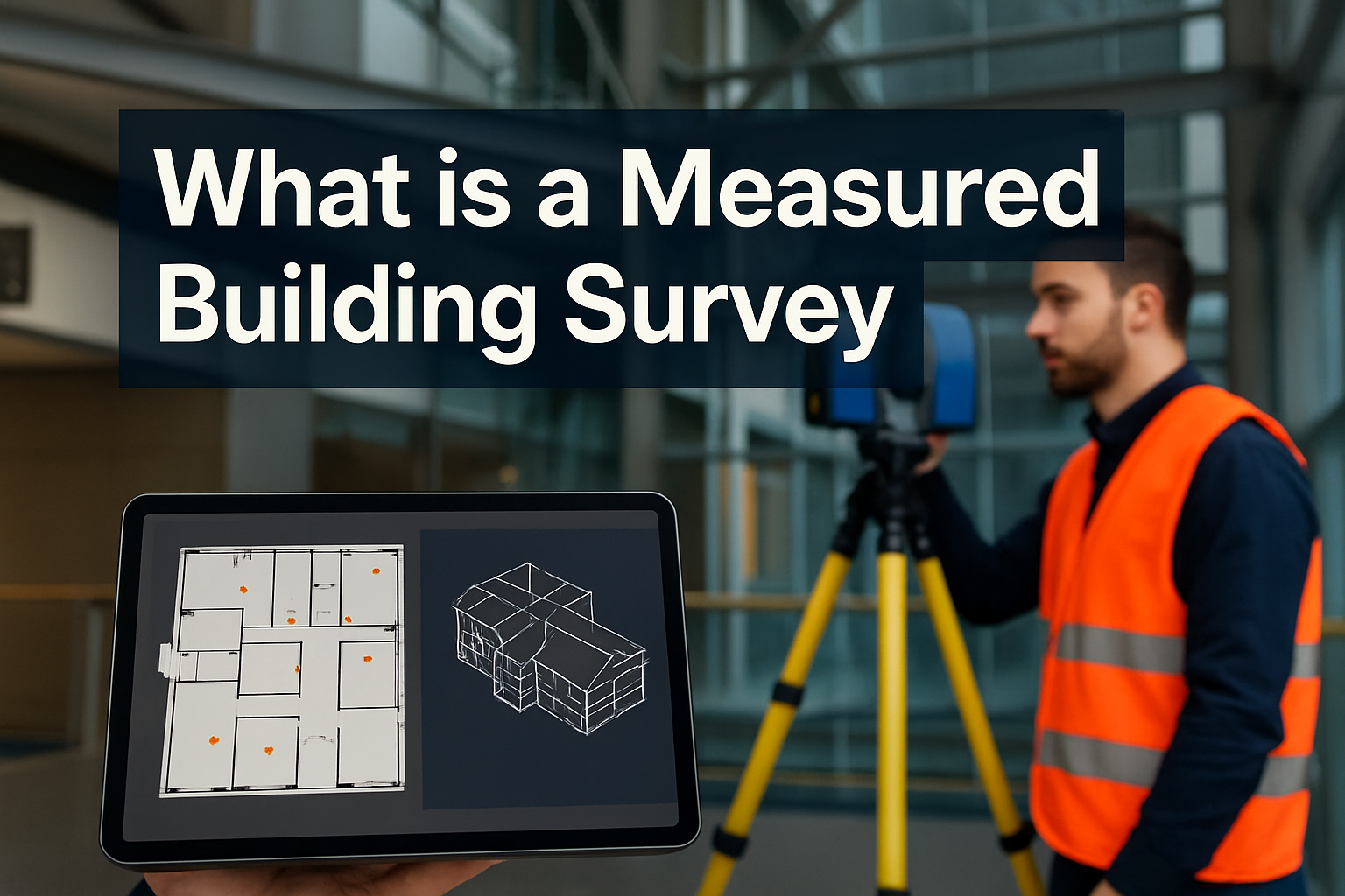
A measured building survey represents the gold standard in architectural documentation, transforming physical buildings into precise digital representations through advanced laser scanning technology and expert surveying techniques. Whether planning a simple office redesign or preserving a centuries-old heritage site, this comprehensive survey methodology provides the foundational data that ensures project success.
Key Takeaways
- 📐 A measured building survey creates highly accurate digital representations of existing buildings using laser scanners and total stations, capturing every structural element with precise dimensions
- 🏗️ Survey outputs include detailed 2D CAD drawings and 3D BIM models featuring floor plans, elevations, sections, and spatial relationships between all architectural features
- 💼 Applications span multiple industries including construction, architectural design, heritage conservation, legal documentation, and facilities management
- ⚡ Key benefits include enhanced precision, reduced project errors, time efficiency, and non-invasive data collection suitable for sensitive structures
- 📊 Professional surveyors deliver tailored deliverables such as Net Internal Area (NIA) calculations, Gross Internal Area (GIA) measurements, and as-built verification documentation
Understanding What is a Measured Building Survey
A measured building survey is a comprehensive digital representation of a property’s structure, layout, and architectural features, created using precise measurements and advanced technology [1]. Unlike simple property inspections or basic floor sketches, these surveys provide millimeter-accurate documentation of every aspect of a building’s physical characteristics.
The Core Components
At its foundation, a measured building survey captures:
- Structural elements: Walls, columns, beams, and load-bearing components
- Architectural features: Doors, windows, staircases, and decorative details
- Spatial relationships: Ceiling heights, room dimensions, and level changes
- Building services: Locations of utilities, HVAC systems, and electrical installations
- External features: Facades, rooflines, and site boundaries
The survey process employs cutting-edge equipment including 3D laser scanners and total stations operated by experienced chartered surveyors who understand both the technical and practical aspects of building documentation [2].
How Technology Transforms Buildings into Data
Modern measured building surveys utilize laser scanning technology that emits millions of measurement points per second, creating what professionals call a “point cloud”—a dense collection of spatial coordinates that forms a three-dimensional digital replica of the surveyed space.
“The precision of laser scanning technology has fundamentally changed how we approach building documentation, reducing measurement errors from centimeters to millimeters.” — Royal Institution of Chartered Surveyors
This point cloud data is then processed using specialized software to generate various deliverables tailored to specific project needs, from traditional 2D floor plans to sophisticated Building Information Modelling (BIM) environments.
What is a Measured Building Survey Used For?
The applications of measured building surveys extend across numerous industries and project types, making them an indispensable tool for property professionals in 2025.
Construction and Renovation Projects
For construction projects, measured surveys provide the critical as-built documentation that architects and contractors need before breaking ground. This includes:
| Project Type | Survey Application | Key Benefit |
|---|---|---|
| Office Refurbishment | Accurate space planning and partition layouts | Optimized workspace design |
| Residential Extensions | Existing structure integration planning | Seamless architectural continuity |
| Commercial Fit-outs | Services coordination and ceiling void analysis | Reduced on-site conflicts |
| Building Conversions | Structural assessment and compliance verification | Regulatory approval facilitation |
Architectural Design and Planning
Architects rely on measured building surveys to create designs that integrate perfectly with existing structures. The survey data provides:
✅ Reliable measurement data that eliminates guesswork and site revisits
✅ Detailed ceiling heights and level changes for accurate spatial planning
✅ Window and door schedules with precise dimensions and locations
✅ Structural constraints identification before design development begins
This precision significantly reduces costly errors and construction surprises that can derail project timelines and budgets [3].
Heritage Conservation and Historic Buildings
In heritage conservation, measured building surveys serve as essential tools for recording detailed ornate details and current conditions of historic buildings. Conservation architects use this data to:
- Document existing conditions before restoration work
- Preserve architectural details digitally for future reference
- Plan sensitive interventions that respect historical integrity
- Create archival records for cultural heritage preservation
The non-invasive nature of laser scanning makes it particularly suitable for fragile or protected structures where traditional measurement methods might cause damage.
Legal and Compliance Documentation
Property transactions, lease agreements, and building permits often require official documentation of floor areas and spatial configurations. Measured building surveys provide:
- Net Internal Area (NIA) calculations for commercial property valuations
- Gross Internal Area (GIA) measurements for development assessments
- Lease plan documentation with certified accuracy
- Planning application drawings that meet local authority requirements
These legally defensible measurements ensure compliance with regulatory standards and provide transparency in property transactions [4].
Structural Engineering Assessments
Structural engineers utilize measured survey data to evaluate structural integrity, plan reinforcements, and conduct safety assessments before undertaking significant building refurbishments. The detailed spatial information enables:
- Load-bearing capacity analysis
- Structural modification planning
- Foundation assessment coordination
- Building stability evaluations
The Measured Building Survey Process: From Site to Deliverables
Understanding what is a measured building survey involves appreciating the sophisticated workflow that transforms raw field data into actionable documentation.
Stage 1: Pre-Survey Consultation
Before any equipment arrives on-site, professional surveyors conduct thorough consultations to understand:
- Project objectives and specific deliverable requirements
- Survey scope including areas to be measured and level of detail needed
- Access arrangements and site-specific constraints
- Timeline expectations and delivery milestones
- Output format preferences (2D CAD, 3D models, BIM integration)
This planning phase ensures the survey captures exactly what the project requires, avoiding unnecessary data collection or missed critical details.
Stage 2: On-Site Data Collection
Experienced surveyors arrive with advanced 3D laser scanning equipment and total stations to capture comprehensive spatial data. The process typically involves:
- Equipment setup at strategic positions throughout the building
- Laser scanning to create dense point cloud data
- Control point establishment for spatial accuracy
- Photographic documentation for visual reference
- Manual verification of critical dimensions
- Site notes recording material types, conditions, and special features
Modern laser scanners can capture up to one million measurement points per second, creating incredibly detailed digital records in a fraction of the time traditional methods required [5].
Stage 3: Data Processing and Model Creation
Back in the office, specialized technicians process the raw scan data using sophisticated software platforms. This stage includes:
- Point cloud registration aligning multiple scans into a unified coordinate system
- Data cleaning removing unwanted elements like furniture or temporary structures
- Model extraction converting point clouds into usable CAD geometry
- Quality control checks verifying accuracy against field measurements
- Detail enhancement adding annotations, dimensions, and specifications
Stage 4: Deliverable Production
The final stage produces tailored deliverables based on project requirements:
2D CAD Drawings:
- Floor plans at various scales (1:50, 1:100, 1:200)
- Elevations showing external facades
- Sections revealing internal vertical relationships
- Reflected ceiling plans for services coordination
3D Models:
- Point cloud files for direct visualization
- Mesh models for rendering and presentation
- BIM-ready models compatible with Revit, ArchiCAD, or other platforms
- Virtual reality environments for immersive project reviews
Key Benefits of Measured Building Surveys
The advantages of professional measured building surveys extend far beyond simple accuracy, delivering tangible value across project lifecycles.
🎯 Enhanced Precision and Reliability
Advanced measurement technology provides accuracy levels of ±2-5mm, dramatically superior to traditional tape measure methods. This precision:
- Eliminates dimensional discrepancies during construction
- Reduces material waste from incorrect measurements
- Enables prefabrication and off-site manufacturing
- Supports tight tolerance requirements in modern construction
⏱️ Time and Cost Efficiency
While measured surveys require upfront investment, they deliver substantial savings through:
- Consolidated site visits capturing all data in a single survey session
- Reduced design revisions due to accurate baseline information
- Fewer construction delays from measurement conflicts
- Minimized contractor contingencies when working with reliable data
Studies indicate that projects utilizing measured building surveys experience up to 30% fewer design changes during construction phases [6].
🏛️ Non-Invasive Data Collection
Laser scanning technology captures comprehensive data without physical contact with building surfaces, making it ideal for:
- Historic structures with fragile finishes
- Occupied buildings requiring minimal disruption
- Hazardous environments where human access is limited
- High-level features difficult to reach with traditional methods
📈 Future-Proof Documentation
Digital survey data creates a permanent record that supports:
- Ongoing facilities management and maintenance planning
- Future renovation or expansion projects
- Property portfolio management
- Historical documentation and archival purposes
The 3D models and point clouds can be revisited years later, providing accurate baseline information without requiring new surveys.
What is a Measured Building Survey Output? Understanding Deliverables
The output of a measured building survey varies based on project requirements, but typically includes combinations of the following formats.
Floor Plans
Detailed plan views showing:
- Room layouts and dimensions
- Wall thicknesses and construction types
- Door swings and window positions
- Fixed equipment and built-in features
- Area calculations (NIA, GIA, usable space)
Floor plans typically include dimension chains providing precise measurements between key points, enabling accurate quantity surveying and cost estimation.
Elevations
External and internal elevation drawings depicting:
- Building facades with architectural details
- Window and door heights and styles
- Material boundaries and finishes
- Decorative elements and ornamentation
- Ground levels and vertical datums
Sections
Cross-sectional cuts revealing:
- Floor-to-ceiling heights
- Structural beam and column positions
- Staircase configurations and headroom clearances
- Roof structures and void spaces
- Level changes and vertical relationships
3D BIM Models
Building Information Modelling deliverables offer:
- Intelligent objects with embedded property data
- Clash detection capabilities for services coordination
- Quantity extraction for cost planning
- Visualization tools for stakeholder communication
- Integration platforms compatible with design software
BIM models represent the cutting edge of measured survey deliverables, transforming static drawings into dynamic information environments that support collaborative project delivery [7].
Point Cloud Data
Raw or processed point cloud files provide:
- Comprehensive spatial records
- Measurement verification capabilities
- Virtual site revisits without physical access
- Base data for multiple derivative products
Choosing the Right Measured Building Survey Provider
Selecting a qualified surveying firm ensures project success and deliverable quality. Consider these essential factors:
Professional Qualifications
Look for surveyors with:
- Chartered status from recognized professional bodies (RICS, CICES, ICES)
- Professional indemnity insurance protecting against errors
- Proven track record in similar project types
- Technical expertise with current surveying technology
Technology and Equipment
Modern surveys require:
- Current generation laser scanners with appropriate range and accuracy specifications
- Processing software capabilities for various output formats
- Quality control procedures ensuring deliverable accuracy
- Data security protocols protecting sensitive project information
Communication and Service
Effective survey providers demonstrate:
- Clear scope definition and quotation processes
- Responsive project communication
- Flexible deliverable customization
- Post-delivery support and clarification services
Portfolio and References
Review previous projects to assess:
- Complexity handling capabilities
- Deliverable quality and presentation standards
- Client satisfaction and testimonials
- Industry sector experience
Common Applications Across Industries
Measured building surveys serve diverse sectors with specialized requirements.
🏢 Commercial Real Estate
- Office space planning and tenant fit-outs
- Retail store design and merchandising layouts
- Building condition assessments for acquisitions
- Lease documentation and area verification
🏛️ Heritage and Conservation
- Historic building recording and archival
- Restoration planning and sensitive interventions
- Archaeological documentation
- Museum and cultural institution facilities
🏗️ Construction and Development
- As-built verification and quality control
- Existing structure integration for extensions
- Site analysis and feasibility studies
- Contractor coordination and clash detection
🏥 Healthcare and Education
- Hospital expansion and department reconfiguration
- School modernization and accessibility improvements
- Laboratory and specialized facility planning
- Compliance verification for regulatory standards
🏭 Industrial and Infrastructure
- Factory layout optimization
- Plant maintenance and asset management
- Infrastructure monitoring and deformation analysis
- Facility management system integration
Measured Building Surveys vs. Traditional Methods
Understanding what is a measured building survey becomes clearer when comparing it to conventional approaches.
| Aspect | Traditional Methods | Measured Building Surveys |
|---|---|---|
| Accuracy | ±10-50mm typical | ±2-5mm achievable |
| Data Density | Selected measurements only | Millions of data points |
| Site Time | Multiple visits often required | Single comprehensive session |
| Access Requirements | Physical contact with all surfaces | Remote measurement capability |
| Deliverable Formats | Primarily 2D drawings | 2D, 3D, BIM, point clouds |
| Future Verification | Requires site revisit | Digital record available |
| Complex Geometry | Difficult and time-consuming | Efficiently captured |
| Cost | Lower initial, higher lifecycle | Higher initial, lower lifecycle |
The transition to laser scanning technology represents a paradigm shift in building documentation, offering capabilities impossible with traditional tape-and-theodolite methods.
The Future of Measured Building Surveys in 2025 and Beyond
The measured building survey industry continues evolving with technological advancement and changing market demands.
Emerging Technologies
- Mobile mapping systems enabling rapid large-scale surveys
- Drone-based photogrammetry for facade and roof documentation
- Artificial intelligence automating model extraction from point clouds
- Augmented reality visualization of survey data on-site
- Real-time scanning providing immediate data feedback
Integration with Digital Twins
Measured surveys increasingly serve as foundational data for digital twin implementations—dynamic virtual replicas of physical buildings that support:
- Predictive maintenance and operational optimization
- Energy performance monitoring and improvement
- Space utilization analysis and workplace strategy
- Emergency response planning and safety management
Sustainability and Building Performance
Accurate as-built documentation enables:
- Retrofit planning for energy efficiency improvements
- Carbon footprint assessment and reduction strategies
- Circular economy approaches to building materials
- Lifecycle analysis and sustainable development
The role of measured building surveys in supporting net-zero carbon objectives positions them as essential tools for sustainable built environment management [8].
Conclusion: The Essential Role of Measured Building Surveys
Understanding what is a measured building survey reveals its critical importance in modern construction, architecture, and property management. These comprehensive digital representations provide the accurate, reliable data that underpins successful projects across industries—from heritage conservation to cutting-edge commercial development.
The benefits are clear: enhanced precision eliminates costly errors, time efficiency accelerates project timelines, non-invasive techniques protect sensitive structures, and comprehensive documentation supports both immediate needs and long-term asset management.
Next Steps for Your Project
If you’re considering a measured building survey for your property or project:
- Define your objectives clearly – Understand what deliverables you need and how they’ll be used
- Engage qualified professionals early – Involve surveyors during project planning stages
- Request detailed proposals – Compare scope, methodology, and deliverable specifications
- Verify credentials and experience – Ensure providers have relevant expertise and professional qualifications
- Plan for data integration – Consider how survey deliverables will interface with design and construction workflows
In 2025’s increasingly digital built environment, measured building surveys represent not just a documentation method, but a strategic investment in project success, risk mitigation, and informed decision-making. Whether renovating a single room or managing a complex portfolio, the precision and comprehensiveness of professional measured surveys provide the foundation for confident, efficient, and successful outcomes.
The question isn’t whether to commission a measured building survey, but rather how to maximize the value these sophisticated tools deliver to your specific project requirements.
References
[1] Royal Institution of Chartered Surveyors (RICS). (2024). “Measured Surveys of Land, Buildings and Utilities, 4th Edition.” RICS Professional Standards.
[2] Historic England. (2023). “3D Laser Scanning for Heritage: Advice and Guidance on the Use of Laser Scanning in Archaeology and Architecture.” Historic England Technical Advice.
[3] Construction Industry Institute. (2024). “Impact of Accurate As-Built Documentation on Construction Project Performance.” CII Research Report.
[4] International Property Measurement Standards Coalition. (2024). “IPMS: Office Buildings.” Global Measurement Standards.
[5] American Society for Photogrammetry and Remote Sensing. (2024). “LiDAR and 3D Imaging Technologies in Building Documentation.” ASPRS Technical Papers.
[6] Building Information Modelling Industry Working Group. (2023). “BIM and Measured Survey Integration: Best Practice Guidelines.” UK BIM Framework.
[7] National Building Specification. (2024). “BIM Object Standard for Measured Survey Data.” NBS BIM Toolkit.
[8] UK Green Building Council. (2024). “Whole Life Carbon Assessment: The Role of Accurate Building Documentation.” UKGBC Technical Report.
SEO Meta Title and Description
Meta Title: What is a Measured Building Survey? Complete Guide 2025
Meta Description: Discover what is a measured building survey, how laser scanning creates accurate 2D/3D models, key benefits, applications, and why precision matters for your project.