Boundary and party wall disputes cost English and Welsh property owners tens of millions of pounds each year in legal fees, remediation works, and lost property value — yet the single most common reason cases collapse or settle for less than they should is poor evidence. Using digital evidence in party wall and boundary disputes — photos, video, and 3D models that stand up in court — is no longer a specialist luxury reserved for high-value commercial litigation. In 2026, it is the baseline standard that competent surveyors, solicitors, and property owners should expect from every site record.
This article explains how to collect, store, and present digital site records so they are admissible, credible, and genuinely useful when negotiations break down and proceedings begin.
Key Takeaways
- Digital evidence is only as strong as its chain of custody — metadata, timestamps, and unbroken storage records are non-negotiable.
- Photographs and video must be captured with verifiable geotags and timestamps to be treated as reliable by courts and mediators.
- 3D laser scans and photogrammetry models provide spatially accurate, tamper-evident records that are increasingly accepted as primary evidence.
- A professionally prepared party wall schedule of condition underpinned by digital evidence is the most powerful pre-emptive tool available to property owners.
- Early investment in quality digital documentation almost always reduces total dispute costs.

Why Digital Evidence Now Defines Party Wall and Boundary Cases
The shift from paper-based to digital evidence in property disputes has been rapid. Courts have moved from treating photographs as supporting material to treating high-quality digital records as primary evidence. Judges, arbitrators, and RICS-appointed surveyors now routinely assess whether digital files carry verifiable metadata before placing weight on them.
Courts increasingly require authentication of digital evidence through metadata analysis to verify the integrity and origin of photos and videos, addressing concerns about potential manipulation [3]. In practical terms, this means a photograph taken on a smartphone without GPS enabled, or a video clip whose file properties have been altered, may be challenged or excluded entirely.
For party wall and boundary matters specifically, the stakes are high. A neighbour who excavates beyond the agreed line, a contractor who damages a shared chimney stack, or a developer who encroaches on a boundary by even 50 millimetres can cause thousands of pounds of damage. Without robust digital evidence captured before, during, and after works, proving what existed — and what changed — becomes a matter of competing assertions rather than verifiable fact.
The Legal Framework That Shapes Admissibility
The Party Wall etc. Act 1996 does not prescribe a specific evidence format, but it does create obligations that make contemporaneous digital records essential. Surveyors appointed under the Act must record the condition of adjoining structures before notifiable works begin. This record — the schedule of condition — is the foundation on which all subsequent damage claims are assessed.
Understanding common misconceptions about party wall agreements is important here. Many property owners assume that a brief written description is sufficient. It rarely is. When a crack appears after excavation works, a written note that says "wall in good condition" tells a court nothing about whether that crack existed before works started. A georeferenced photograph with an embedded timestamp, cross-referenced to a 3D point-cloud baseline, tells a court almost everything it needs.
Civil proceedings in England and Wales are governed by the Civil Procedure Rules (CPR), which require that evidence be proportionate, reliable, and capable of being tested. Digital files that carry intact metadata, stored in a format that prevents retrospective editing, satisfy these requirements far more readily than printed photographs or handwritten notes.
What Metadata Actually Proves
Every digital photograph, video clip, and scan file carries embedded data beyond the visible image. This metadata typically includes:
| Metadata Field | What It Proves |
|---|---|
| Timestamp | When the image was captured |
| GPS coordinates | Where the device was located |
| Device identifier | Which camera or scanner produced the file |
| File hash | Whether the file has been altered since creation |
| Altitude data | Relevant for drone footage |
| Camera settings | Consistency with claimed conditions |
In construction and property disputes, maintaining a workflow that preserves metadata — including timestamps and geotags — is essential for photo documentation to be legally defensible [8]. This means capturing images in RAW or full-resolution JPEG format, never compressing or re-saving files before they are stored in a secure repository, and logging the chain of custody from capture to submission.
Collecting Digital Evidence: Photographs, Video, and Site Records
The quality of digital evidence in party wall and boundary disputes is determined almost entirely by decisions made on site, not in the office. A surveyor who captures 200 well-composed, metadata-intact photographs on the day of inspection creates a record that can withstand cross-examination. One who relies on a dozen compressed images emailed to themselves creates a liability.
Photographic Standards for Party Wall Surveys
A defensible photographic record for a party wall or boundary matter should follow a structured protocol:
Before works begin:
- Photograph all surfaces of the party wall or boundary structure from multiple angles
- Capture existing cracks, staining, spalling, or movement with a scale rule in frame
- Record the condition of adjacent structures, including floors, ceilings, and external elevations
- Take overview shots that establish spatial context — which wall, which property, which direction
During works:
- Document each stage of excavation, underpinning, or structural alteration
- Capture any incidents — unexpected voids, groundwater ingress, cracking — immediately
- Record the position of temporary works, props, and protective measures
After works:
- Photograph all reinstated surfaces
- Document any new cracking or movement that was not present at the pre-works stage
- Capture the final condition of boundary markers and fencing
In construction disputes, photos documenting work progress must include verifiable metadata — timestamps and geotags — to be admissible in court [8]. Using a dedicated site documentation app rather than a standard camera app significantly improves metadata integrity, as many professional platforms automatically lock timestamps and coordinates at the point of capture.
For those unfamiliar with what a formal pre-works inspection involves, the top questions about party wall surveys provides a useful overview of the surveyor's role and responsibilities.
Video Evidence: Continuity and Context
Video captures what photographs cannot — the sequence of events, the extent of movement, and the spatial relationship between elements. A 60-second walkthrough of a party wall before excavation begins, narrated by the surveyor with date and time confirmed verbally at the start, creates a continuous record that is extremely difficult to challenge.
Key principles for admissible video evidence:
- Record date and time verbally at the start of each clip
- Do not edit or cut footage before it is stored — submit raw clips
- Use a device that embeds GPS data in video files
- Store files immediately to a secure, timestamped cloud repository
- Avoid using social media platforms as storage, as compression strips metadata
Drone footage is increasingly valuable for boundary disputes involving large plots or where physical access is restricted. Aerial video provides an objective overhead perspective that is difficult to dispute. However, drone operators must hold the appropriate Civil Aviation Authority permissions, and footage must be captured in a format that retains full metadata.
Maintaining Chain of Custody
The chain of custody is the documented history of who collected evidence, how it was stored, and who had access to it. Courts treat breaks in chain of custody as grounds to challenge admissibility. A practical chain of custody protocol for digital site records includes:
- Capture files directly to a secure, cloud-based platform with automatic timestamping
- Generate a file hash immediately after capture and record it separately
- Restrict access to the evidence repository to named individuals
- Log every instance of file access, download, or sharing
- Never alter the original file — work only from verified copies
Expert forensic analysis of digital images, including authentication and tampering detection, is crucial for litigation [2]. If a dispute escalates to court, a forensic expert may be instructed to verify that photographic evidence has not been manipulated. Files that have been re-saved, compressed, or had their metadata stripped will fail this analysis.
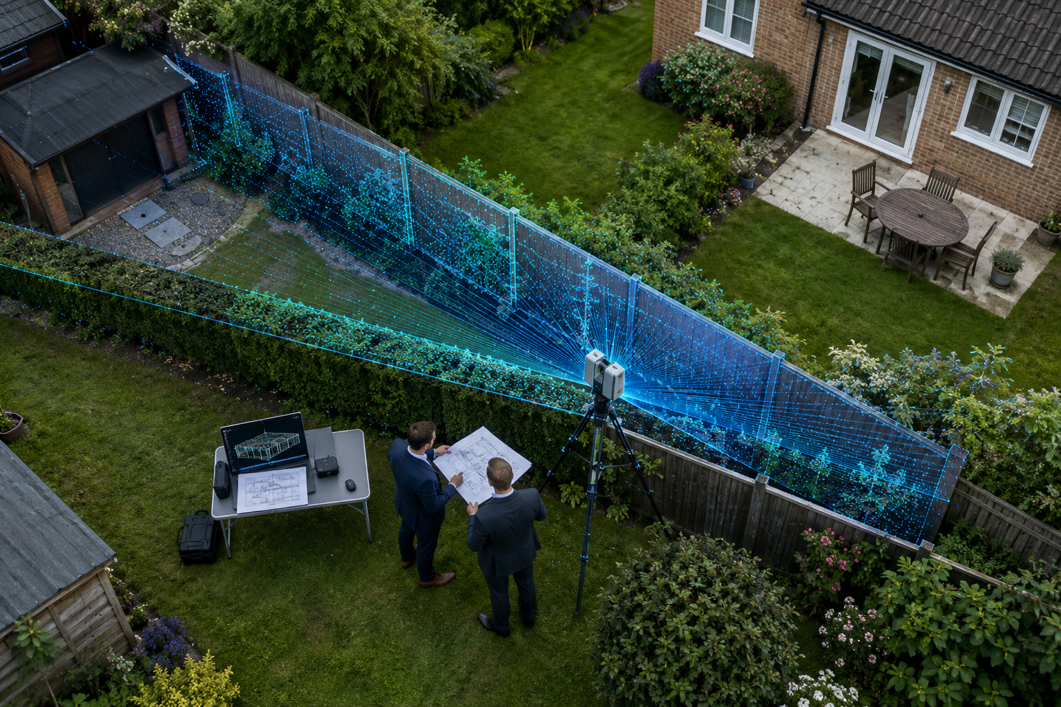
3D Scanning and Modelling: The Gold Standard for Spatial Evidence
Three-dimensional documentation represents the most significant advance in property dispute evidence of the past decade. Where photographs provide a two-dimensional record and video provides a temporal one, 3D scans provide a spatially accurate, measurable model of a structure or boundary at a specific point in time.
How 3D Scanning Works in a Property Context
Two primary technologies are used in party wall and boundary disputes:
LiDAR (Light Detection and Ranging) / Laser Scanning: A tripod-mounted scanner emits laser pulses and measures their return time to build a precise point cloud — a three-dimensional map of every surface within range. Accuracy is typically within 2-3 millimetres at distances up to 30 metres. FARO and Leica scanners are the industry standard for legal-grade work.
Photogrammetry: Software processes overlapping photographs to generate a 3D mesh model. Less precise than LiDAR but significantly cheaper and increasingly accurate with modern processing algorithms. Suitable for smaller structures and boundary features.
3D modeling based on FARO scans offers accurate visualization that aids investigators and decision-makers in understanding the spatial dynamics of incidents [americanbar.org]. In a boundary dispute, a pre-works 3D scan establishes the precise position of every wall, fence post, and boundary marker. A post-works scan of the same area, overlaid on the baseline model, will show any deviation to millimetre accuracy. This is objective, quantifiable evidence that is extremely difficult to contest.
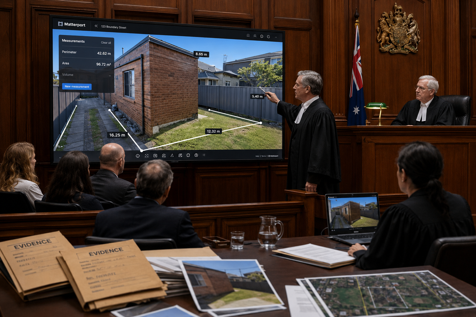
Matterport-style 3D scans offer precise, time-stamped documentation of scenes, enabling decision-makers to virtually walk through properties and understand spatial relationships — particularly beneficial in property disputes [4]. Legal and insurance professionals increasingly use comprehensive 3D documentation services, including pre-loss property scans and post-loss documentation, as indisputable evidence that strengthens claims and accelerates settlements [10].
Presenting 3D Models in Negotiations and Court
A 3D model is only useful if the audience can understand it. Platforms designed for legal use allow attorneys, surveyors, and judges to navigate photorealistic spatial reconstructions without specialist software [9]. This is important in mediation and arbitration, where decision-makers may have no technical background.
Accurate, to-scale 3D reconstructions can replace physical site visits, saving time and expense while enhancing understanding of the scene layout [5]. In a party wall dispute involving basement excavation — a particularly complex area where basement works and party wall obligations intersect — a 3D model showing the relationship between the excavation depth, the neighbouring foundation, and the party wall structure can make a technically complex argument immediately comprehensible.
Engineering animations and forensic video specialists can create precise, court-accepted animations and simulations for various stages of a case, including mediations and trials [7]. These are distinct from 3D scans — they are constructed visualisations rather than direct measurements — and must be clearly presented as such to avoid challenges to their evidential status.
Using Digital Evidence in Party Wall and Boundary Disputes: Integration with the Schedule of Condition
The schedule of condition is the document that defines the pre-works baseline. Integrating 3D scan data, georeferenced photographs, and video walkthroughs into a single, indexed schedule creates a record that is comprehensive, navigable, and court-ready.
A well-structured digital schedule of condition should include:
- An indexed library of photographs with visible metadata
- Video walkthroughs of all affected areas
- A 3D scan baseline with spatial coordinates
- Written descriptions cross-referenced to specific images and scan data
- A signed declaration from the surveyor confirming the date, time, and method of capture
This integration is what transforms a collection of files into evidence. The party wall schedule of condition prepared by a qualified surveyor should, in 2026, be expected to meet this standard as a matter of course.
Avoiding Common Pitfalls When Using Digital Evidence in Party Wall and Boundary Disputes
Even well-intentioned digital evidence programmes fail when basic protocols are not followed. The most common errors that undermine admissibility include:
Metadata stripping: Sending photographs via WhatsApp, email compression, or social media automatically strips GPS and timestamp data. Always transfer files directly between devices or via secure cloud platforms.
Delayed capture: Evidence captured days after an incident is inherently weaker than evidence captured at the time. Establish a protocol that requires immediate documentation of any incident, crack, or unexpected finding.
Inconsistent coverage: A photographic record that covers three walls of a party wall but not the fourth will be challenged. Systematic coverage protocols prevent gaps that opponents will exploit.
Failure to authenticate: Expert forensic image analysis can verify that photographs are genuine and unaltered [2]. Proactively commissioning authentication of key evidence before proceedings begin removes this line of attack.
Ignoring the Act's requirements: Failing to serve proper notice before works begin undermines the entire evidence framework. Understanding the consequences of ignoring the Party Wall Act makes clear why procedural compliance and evidence collection must go hand in hand.
When a neighbour refuses access for a pre-works survey, the digital evidence gap this creates can be significant. Knowing how to handle situations where a neighbour refuses party wall works is essential context for any surveyor managing a contentious site.
Admissibility vs. Weight: Understanding the Distinction
A piece of evidence can be admissible — legally capable of being considered by a court — while carrying little weight because it is incomplete or unverified. The goal is not simply to get digital evidence before a tribunal; it is to ensure that evidence is compelling enough to determine the outcome.
Weight is determined by:
- The reliability of the capture method
- The integrity of the chain of custody
- The expertise of the person who collected it
- The consistency of the evidence with other known facts
- Whether it has been independently verified or authenticated
A 3D scan captured by a RICS-qualified surveyor, stored in a tamper-evident platform, and authenticated by a forensic expert carries maximum weight. A photograph taken on a personal phone, emailed to a solicitor, and printed for court carries almost none.
Conclusion
Using digital evidence in party wall and boundary disputes — photos, video, and 3D models that stand up in court — is not a technical afterthought. It is the foundation of every credible dispute resolution process, from initial negotiation through to litigation. The difference between a well-documented case and a poorly documented one is often the difference between a swift settlement and years of costly proceedings.
Actionable next steps for property owners and surveyors:
- Commission a professionally prepared schedule of condition before any notifiable works begin, specifying that it must include georeferenced photographs, video, and — where the works are significant — a 3D scan baseline.
- Establish a metadata-preserving file transfer protocol from day one. Never use compressed messaging apps to share evidential photographs.
- Instruct a RICS-qualified surveyor who can demonstrate familiarity with digital evidence standards, not simply one who takes photographs on site.
- If a dispute is already underway and the existing evidence record is weak, consider commissioning a forensic image authentication review of what is available before proceedings are issued.
- For complex cases involving basement excavation, boundary encroachment, or structural damage, invest in 3D laser scanning. The cost is a fraction of the legal fees that inadequate evidence generates.
Digital technology has given property owners and their advisors tools that were unimaginable twenty years ago. The obligation now is to use those tools correctly, consistently, and with the rigour that courts and arbitrators expect.
References
[1] Matterport 3d Scan – https://www.fireoriginandcause.com/matterport-3d-scan.html?utm_source=openai
[2] Image Forensics – https://litigationforensics.com/services/image-forensics?utm_source=openai
[3] How Digital Footage And Metadata Are Transforming Disputes – https://www.iplocation.net/how-digital-footage-and-metadata-are-transforming-disputes?utm_source=openai
[4] Legal Forensic – https://southeast3dtours.com/pages/legal-forensic.html?utm_source=openai
[5] Models Litigation – https://hts-3d.com/models-litigation/?utm_source=openai
[6] My Technology Can Recreate Scientifically Accurate Crime Scene Images In 3d Video – https://www.policemag.com/articles/my-technology-can-recreate-scientifically-accurate-crime-scene-images-in-3d-video?utm_source=openai
[7] Animations – https://forensicdjs.com/animations/?utm_source=openai
[8] Work Progress Photo Evidence Appellate Court – https://truescreen.io/insights/work-progress-photo-evidence-appellate-court/?utm_source=openai
[9] Best 3d Model Viewers For Court – https://www.skyebrowse.com/news/posts/best-3d-model-viewers-for-court?utm_source=openai
[10] Legal Insurance – https://tourmy.co/legal-insurance?utm_source=openai