

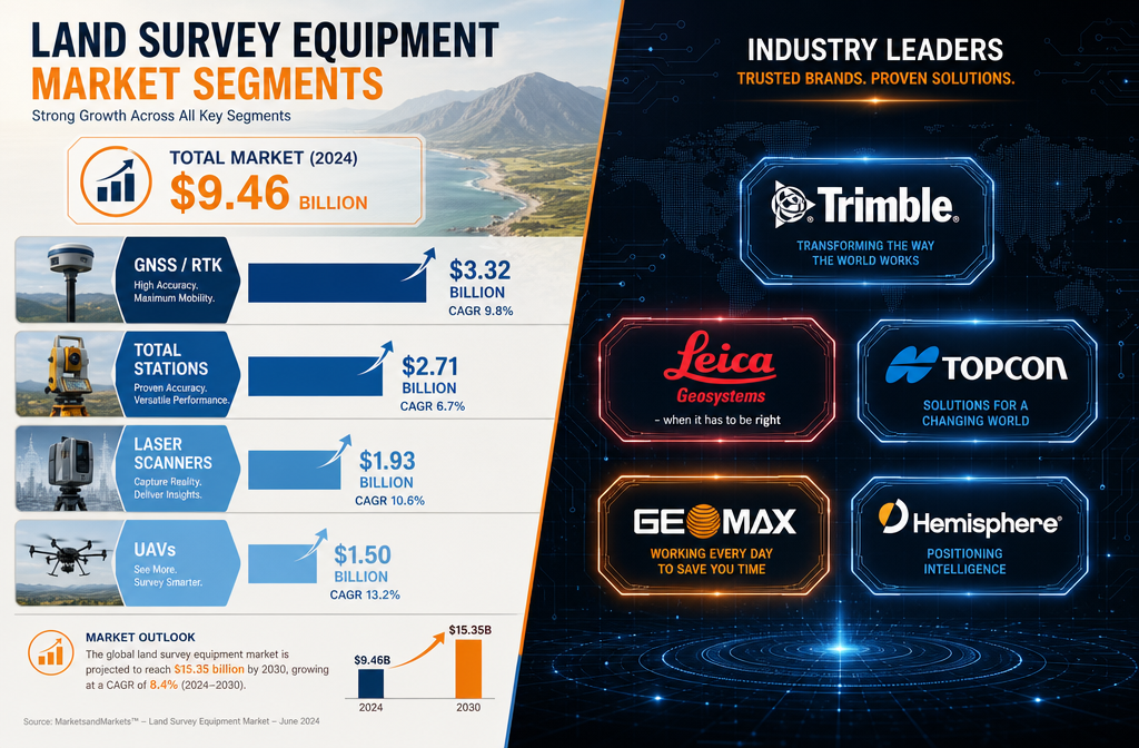
The global land survey equipment market crossed an estimated US$9.5–10.3 billion in 2026 — and the tools driving that number are no longer optional extras for serious survey firms. [1][6] This guide to the Top Land Survey Equipment for 2026: Reviewing Total Stations, RTK GPS, and Laser Scanners Amid Market Boom breaks down the specs, prices, and performance of the instruments that matter most, with a buyer's lens shaped by infrastructure-driven demand across road, rail, utilities, and urban redevelopment projects.
Whether a firm is equipping a new team or upgrading legacy kit, the choices made in 2026 will define competitive positioning for the rest of the decade.
Key Takeaways 🎯
- The 2026 land survey equipment market is worth US$9.5–10.3 billion, fuelled by infrastructure spending and digital workflow adoption.
- GNSS/RTK receivers and robotic total stations remain the revenue backbone; laser scanners and UAVs are the fastest-growing categories.
- The "big five" brands — Trimble, Topcon, Leica/Hexagon, GeoMax, and Hemisphere GNSS — dominate professional-grade instruments.
- In 2026, field software ecosystems and after-sales support often matter more than raw hardware specs.
- Smart firms are choosing modular, multi-role platforms and renting specialist sensors rather than over-committing to every hardware cycle.
The 2026 Market Landscape: Why Equipment Choices Matter More Than Ever
A Market Shaped by Infrastructure Demand
Government-backed infrastructure programmes — transport corridors, utility upgrades, and urban redevelopment — are the single biggest driver of equipment spending in 2026. [3] UK and EU agencies are now standardising on GNSS-integrated robotic total stations and 3D laser scanners as the baseline kit for road and rail projects through 2030. These are no longer "nice-to-have" tools; they are contract requirements. [3]
Market research projecting to 2036 shows that growth is concentrated in Asia-Pacific and North America, driven by urbanisation and large-scale infrastructure budgets. Vendors are responding by bundling hardware with cloud platforms and service contracts, turning one-off purchases into longer-term relationships. [6]
💡 Pull Quote: "Agencies are standardising on GNSS-integrated robotic total stations and 3D laser scanners as the default baseline kit for road and rail projects through 2030." [3]
The Big Five Brands in 2026
An early-2026 comparative review identifies the same five manufacturers dominating professional-grade instruments: [1]
| Brand | Strength in 2026 |
|---|---|
| Trimble | Integrated field-to-office ecosystem (Access, Business Center, Connect) |
| Leica / Hexagon | High-precision total stations and laser scanners |
| Topcon | Construction-oriented GNSS and machine control |
| GeoMax | Cost-conscious, Leica-backed option for budget-aware firms |
| Hemisphere GNSS | Rising OEM-embedded GNSS specialist |
For firms working on measured surveys and as-built documentation, understanding which brand's ecosystem aligns with existing office software is as important as comparing hardware datasheets.
Reviewing the Top Land Survey Equipment for 2026: Total Stations, RTK GPS, and Laser Scanners
🔭 Total Stations: The Workhorse of the Modern Survey Firm
What the Market Says in 2026
Professional discussions in early 2026 consistently point to mid-range robotic total stations as the sweet spot for most boundary, topographic, and construction stakeout work. [9] The models cited most often include:
- Leica TS13 / TS16 — benchmark for precision and Leica's GeoMoS integration
- Trimble S5 / S7 — strong field software integration via Trimble Access
- Topcon GT-series — competitive pricing with solid construction-site durability
Typical specs for this tier:
- Angular accuracy: 1–3 arc seconds
- Reflectorless EDM range: 800–1,000 m
- Integrated GNSS for localisation
- Robotic (motorised) targeting
Key Buying Considerations
Users in 2026 emphasise that field software and after-sales support are as decisive as the specs sheet. [9] A total station that integrates seamlessly with the office's BIM or CAD workflow saves hours per project. Firms should also factor in:
- ✅ Manufacturer's local service network
- ✅ Software update frequency and cost
- ✅ Compatibility with existing GNSS rovers
- ✅ Battery life and hot-swap capability on long site days
For projects involving construction and condition surveys or building regulation compliance testing, a robotic total station with sub-2-arc-second accuracy and reliable reflectorless EDM is the professional standard.
📡 RTK GPS / GNSS Receivers: Centimetre Accuracy as the New Baseline
Top Picks for 2026
Independent dealer rankings in 2026 show that multi-constellation, multi-frequency receivers with IMU-based tilt compensation are now the standard expectation, not a premium feature. [5] Leading models include:
| Receiver | Key Feature | Tilt Compensation |
|---|---|---|
| Emlid Reach RS3 | Open ecosystem, strong community support | Up to 60° |
| Stonex S990A | Rugged build, long battery life | Up to 60° |
| South Galaxy G7 | Competitive price-to-performance | Up to 60° |
| CHC Navigation i90/i93 | Reliable multi-band tracking | Up to 60° |
| Tersus Oscar | Strong under-canopy performance | Up to 60° |
Typical RTK fixed accuracy across top 2026 receivers:
- Horizontal: 8–10 mm + 1 ppm
- Vertical: 15–20 mm + 1 ppm
What Actually Differentiates Receivers in 2026
Raw accuracy figures are nearly identical across leading units. The real differentiators are: [5]
- Signal tracking under tree canopy — critical for boundary and forestry work
- Integrated radios and modems — affects range and correction reliability
- Subscription-based corrections services — ongoing cost that must be budgeted
- Ecosystem lock-in — some receivers tie users to proprietary correction networks
For firms exploring the cost of a measured building survey, GNSS accuracy directly affects the time spent on site and the density of control points required — both of which influence final project costs.
🔴 Laser Scanners: From Niche Add-On to Competitive Necessity
The Shift in 2026
Laser scanning has crossed a threshold in 2026: clients on infrastructure and urban projects now routinely request full 3D deliverables, making terrestrial scanning a competitive necessity rather than a differentiator. [4] Survey firms report capturing bridges, utilities, and complex architectural features in minutes rather than hours, feeding directly into BIM and digital twin workflows.
Key scanner categories in 2026:
- High-speed terrestrial scanners (e.g., Leica RTC series, Trimble X-series) — best for large infrastructure and industrial sites
- Scanning total stations / hybrid instruments — capture both discrete measurements and dense point clouds from a single setup
- Mobile mapping systems — vehicle or backpack-mounted for corridor scanning
Performance Benchmarks to Expect
| Feature | Entry-Level 2026 | Professional-Grade 2026 |
|---|---|---|
| Scan speed | ~500,000 pts/sec | 1–2 million pts/sec |
| Range | 80–150 m | 300–600 m |
| Accuracy | 3–6 mm @ 10 m | 1–3 mm @ 10 m |
| Point cloud output | Basic XYZ | Full-colour, registered |
For firms offering premium drone surveys alongside terrestrial scanning, the combination of aerial and ground-based point clouds creates the most complete as-built datasets available.
🚁 UAVs: Now a Standard Part of the Survey Equipment Stack
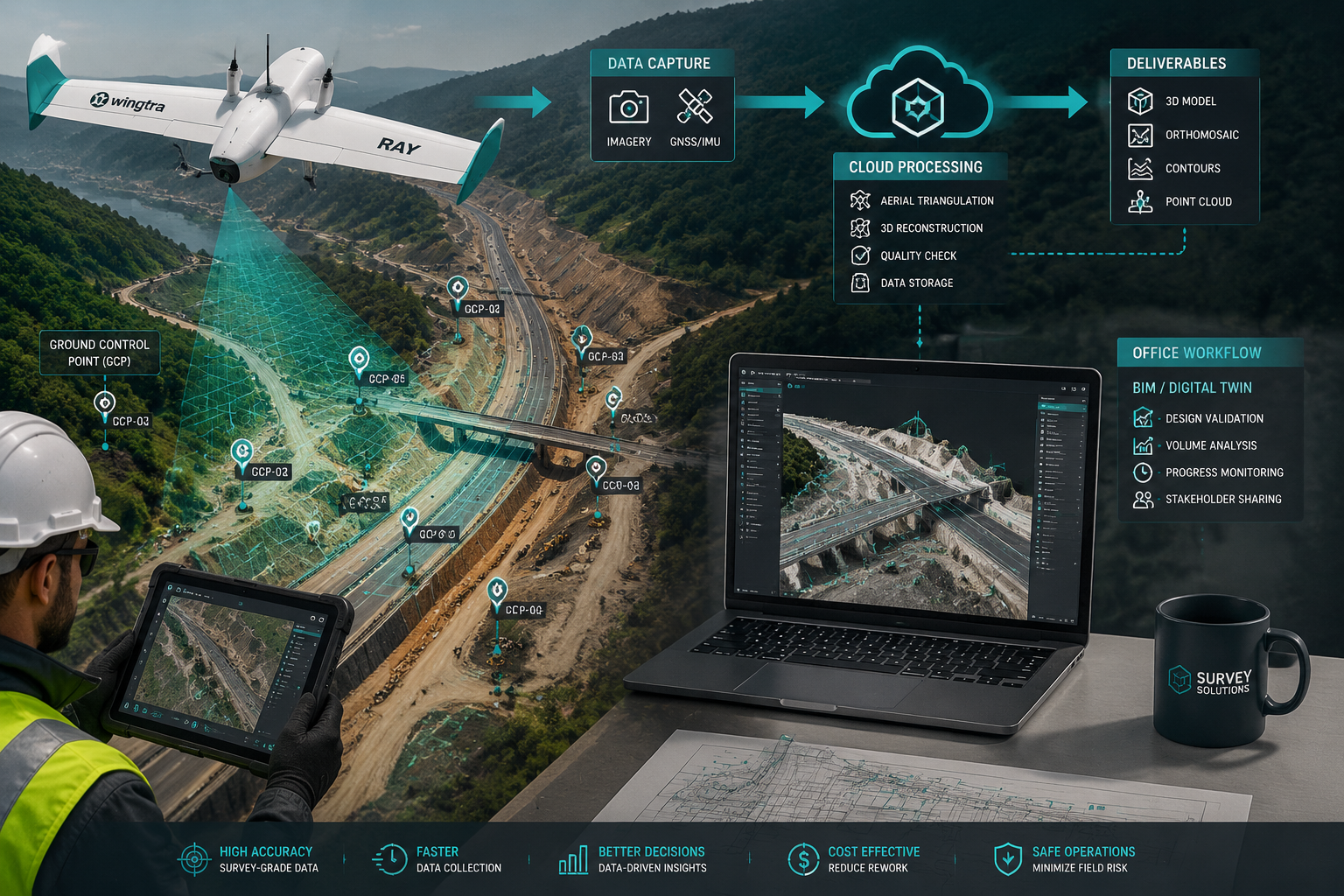
By 2026, drones have effectively joined the standard land survey equipment stack — particularly for corridor mapping and large-area topographic work. [2][8] Early-2026 buyer guides name the Wingtra Ray as the leading option for large-area mapping, citing:
- Fixed-wing VTOL design for long endurance
- RGB cameras up to 61 MP with oblique photogrammetry capability
- Optional multispectral sensors and LiDAR payload
- Sub-decimetre accuracy when paired with RTK ground control
Modern survey firms pair UAV photogrammetry or LiDAR with RTK GNSS receivers to achieve sub-decimetre accuracies over large extents — a combination that would have required weeks of ground survey just five years ago. [2]
💡 Pull Quote: "By 2026, drones are no longer a specialist tool — they are part of the baseline survey equipment stack for any firm working at scale." [2]
Smart Buying Strategies: Navigating the Top Land Survey Equipment for 2026 Market Boom
The Case for Modular, Multi-Role Platforms
Early-2026 market analysis reveals a clear strategic trend: firms are avoiding over-commitment to the latest hardware every cycle. [10] Instead, the most competitive survey businesses are:
- Investing in versatile instruments that serve multiple roles (robotic total station + GNSS rover + drone + mid-range scanner)
- Relying on software updates to extend hardware life
- Adopting subscription-based software rather than perpetual licences
- Renting ultra-high-end scanners or specialist sensors on a project-by-project basis [10]
This approach reflects both the rapid pace of technology turnover and the reality of uncertain project pipelines. A modular strategy also reduces the risk of expensive instruments sitting idle between specialist jobs.
Build vs. Rent: A Practical Framework
| Scenario | Buy | Rent |
|---|---|---|
| Daily use on all projects | ✅ Robotic total station | — |
| Weekly RTK control work | ✅ GNSS receiver | — |
| Occasional large-area scan | — | ✅ High-end terrestrial scanner |
| One-off specialist corridor | — | ✅ Mobile mapping system |
| Regular drone mapping | ✅ Mid-range UAV | — |
Understanding the True Cost of Ownership
When evaluating top land survey equipment for 2026, the purchase price is only the starting point. Firms should also budget for:
- Annual software/subscription fees (corrections services, office software)
- Calibration and service contracts (typically 5–10% of instrument value per year)
- Training time for new platforms
- Accessories and consumables (batteries, prisms, targets, cases)
For context on how professional survey costs translate to client pricing, the cost of a measured building survey provides a useful benchmark for understanding how equipment investment flows through to project fees.
Market Outlook: What's Driving Growth Through 2030
The fastest-growing categories in the land survey equipment market are laser scanning and UAV solutions, measured by CAGR, while GNSS/RTK and total stations still account for the majority of revenue. [6]
Key growth drivers through 2030:
- 🏗️ Infrastructure spending — road, rail, utilities, and urban regeneration programmes
- 🏙️ BIM and digital twin mandates — clients and agencies requiring 3D deliverables
- 🤖 Automated machine control — construction equipment guided by real-time GNSS
- 🌍 Urbanisation in Asia-Pacific — largest single regional growth driver [6]
- 📡 Integrated GNSS + inertial solutions — supporting autonomous construction and real-time monitoring
For property professionals interested in how survey data feeds into asset valuation, understanding land value calculation becomes increasingly relevant as digital survey datasets improve the precision of development appraisals.
Conclusion: Actionable Next Steps for 2026
The Top Land Survey Equipment for 2026: Reviewing Total Stations, RTK GPS, and Laser Scanners Amid Market Boom comes down to a clear set of priorities. The market is large, the technology is maturing fast, and the firms winning work are those that match instrument capability to project demand — without over-spending on capability they will rarely use.
Actionable steps for survey firms and property professionals in 2026:
- Audit current kit against the project types generating the most revenue — identify genuine gaps rather than chasing new releases.
- Prioritise software ecosystem fit over marginal hardware spec differences when selecting total stations or GNSS receivers.
- Add drone capability if large-area or corridor mapping is part of the pipeline — the ROI is now well-established.
- Rent before buying for laser scanning until project volume justifies ownership.
- Budget for subscriptions and service — the true cost of 2026 survey equipment includes ongoing software and correction service fees.
- Stay informed about what measured surveys involve and how evolving equipment standards affect deliverable quality and client expectations.
The 2026 market boom rewards firms that invest strategically — not those that simply spend the most.
References
[1] Best Surveying Equipment Brands – rtkgpssurveyequipment.com
[2] Best Drones For Surveying In 2026 Duncan Parnell – duncan-parnell.com
[3] Navigating 2026 Land Survey Equipment Market Growth Top Tools For Infrastructure Projects 2 – wimbledonsurveyors.com
[4] Navigating The 2026 Land Survey Equipment Boom Total Stations Gps And Laser Scanners Reviewed – nottinghillsurveyors.com
[5] Top 5 Best Rtk Gps Receivers For Land Surveyors – globalgpssystems.com
[6] Land Survey Equipment Market – futuremarketinsights.com
[8] Watch – youtube.com
[9] Best Total Station For Small Survey Firm In 2026 – reddit.com
[10] 2026 Surveying Trends How Survey Firms Are Adapting Without Overcommitting – munsonedsurvey.com