The surveying profession stands at a transformative crossroads in 2026. What once required specialized equipment, extensive training, and weeks of fieldwork can now be accomplished in days—sometimes hours. Reality Capture Goes Mainstream: Integrating 3D Laser Scanning and Mobile Mapping in 2026 Surveys represents more than just technological advancement; it signals a fundamental shift in how professionals document, analyze, and deliver spatial data to clients. The convergence of artificial intelligence, cloud computing, and increasingly affordable hardware has democratized precision measurement, transforming reality capture from a specialized niche into an everyday toolkit for surveyors, architects, and construction professionals.
This evolution hasn't happened overnight. The journey from bulky, expensive laser scanning systems to today's portable, AI-enhanced mobile mapping solutions reflects years of innovation. Today's surveying professionals can choose from an integrated technology stack that combines LiDAR mapping, GNSS RTK systems, UAV photogrammetry, mobile mapping systems, and AI-powered real-time data processing[5]. The result? Faster project timelines, enhanced client collaboration, and unprecedented accuracy that meets modern industry standards.
Key Takeaways
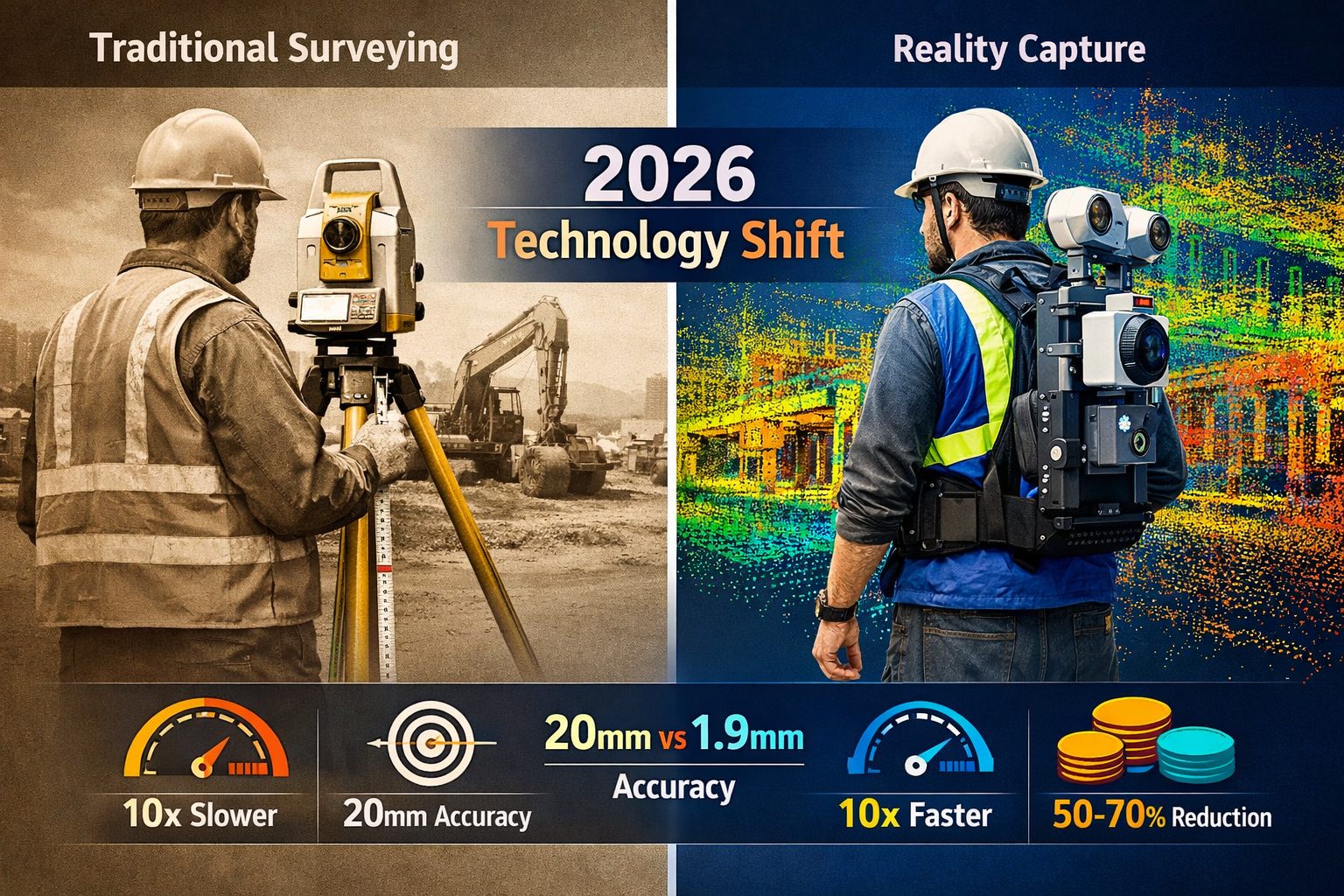
- Hybrid workflows combining static and mobile scanning deliver optimal results: static LiDAR provides survey-grade precision of 1.9mm for control points, while mobile systems capture data 10x faster at 15-20mm accuracy[4]
- Cost reductions of 50-70% in field operations make reality capture accessible to more projects, though data processing considerations remain important for budget planning[4]
- Mobile LiDAR accuracy of approximately 20mm meets BOMA 2026 standards for rentable area calculations and as-built documentation, validating its use for commercial applications[4]
- AI-powered cloud platforms enable real-time data processing and client collaboration, accelerating project delivery from weeks to days
- Enhanced safety protocols allow operators to capture hazardous environments remotely, reducing workplace risks while maintaining data quality[2]
The Technology Revolution: From Specialized Tools to Everyday Solutions
Understanding the Reality Capture Ecosystem in 2026
The landscape of reality capture technology has expanded dramatically. Modern surveying professionals now work with an interconnected ecosystem of tools that would have seemed like science fiction just a decade ago. At the heart of this revolution lies 3D laser scanning technology that has achieved remarkable performance milestones: scanning systems now capture 2 million points per second, while hardware costs have dropped significantly compared to decade-ago pricing[2].
This technological maturation has created distinct categories of capture systems, each optimized for specific applications:
Static Terrestrial Laser Scanning (TLS) remains the gold standard for precision work. These tripod-mounted systems deliver survey-grade accuracy of 1.9mm[4], making them indispensable for projects requiring absolute precision. Engineers rely on static scanners for construction and condition surveys where millimeter-level accuracy determines structural integrity assessments.
Mobile LiDAR Systems have emerged as the speed champions of reality capture. Whether mounted on backpacks, vehicles, or handheld devices, these SLAM-based (Simultaneous Localization and Mapping) systems achieve real-world accuracy of 15-20mm while operating approximately 10x faster than static scanning systems[4]. This speed advantage enables capture of 500,000 square foot commercial towers in just a few days[4]—a timeline impossible with traditional methods.
Unmanned Aerial Vehicles (UAVs) continue their rapid adoption as drone technology becomes cheaper and more accessible to surveying professionals[5]. Modern drone surveys integrate seamlessly with ground-based capture systems, providing aerial perspectives that complete the three-dimensional picture.
The Accuracy Versus Speed Equation
One of the most important developments in Reality Capture Goes Mainstream: Integrating 3D Laser Scanning and Mobile Mapping in 2026 Surveys is the establishment of a clear accuracy hierarchy that helps professionals make informed technology choices[4].
| Technology Type | Accuracy Range | Capture Speed | Best Applications |
|---|---|---|---|
| Static TLS | 1.9mm | Baseline (1x) | Survey control, precision measurements, structural monitoring |
| Mobile LiDAR | 15-20mm | 10x faster | Large area capture, as-built documentation, facility management |
| UAV Photogrammetry | 20-50mm | 5-8x faster | Site surveys, topographic mapping, roof inspections |
| Hybrid Workflow | 1.9-20mm | 3-5x faster | Complex projects requiring both precision and speed |
Understanding this hierarchy empowers surveying teams to deploy the right tool for each project phase. For comprehensive Level 3 building surveys, professionals might use static scanners for critical structural measurements while employing mobile systems to rapidly document general conditions throughout the property.
Cost Considerations: Field Versus Processing
The financial equation of reality capture has shifted significantly. Mobile capture delivers 50-70% cost savings in field operations[4]—a compelling advantage that has accelerated adoption across the industry. However, professionals must understand the complete cost picture.
While mobile systems dramatically reduce field time and labor costs, their "noisier" data can increase Scan to BIM modeling costs by approximately 20%[4] during post-processing. This trade-off requires careful project evaluation. For time-sensitive projects where field access is limited or expensive, the mobile approach still delivers net savings. For projects requiring extensive BIM deliverables with minimal tolerance for modeling ambiguity, static scanning may prove more economical overall.
The democratization of hardware pricing has been equally transformative. Equipment that cost hundreds of thousands of pounds a decade ago now comes in at a fraction of that price, while delivering superior performance[2]. This accessibility has enabled smaller surveying firms to compete for projects previously dominated by large organizations with substantial capital equipment budgets.
Reality Capture Goes Mainstream: The Hybrid Workflow Advantage
Building the Precision Skeleton with Static Scanning
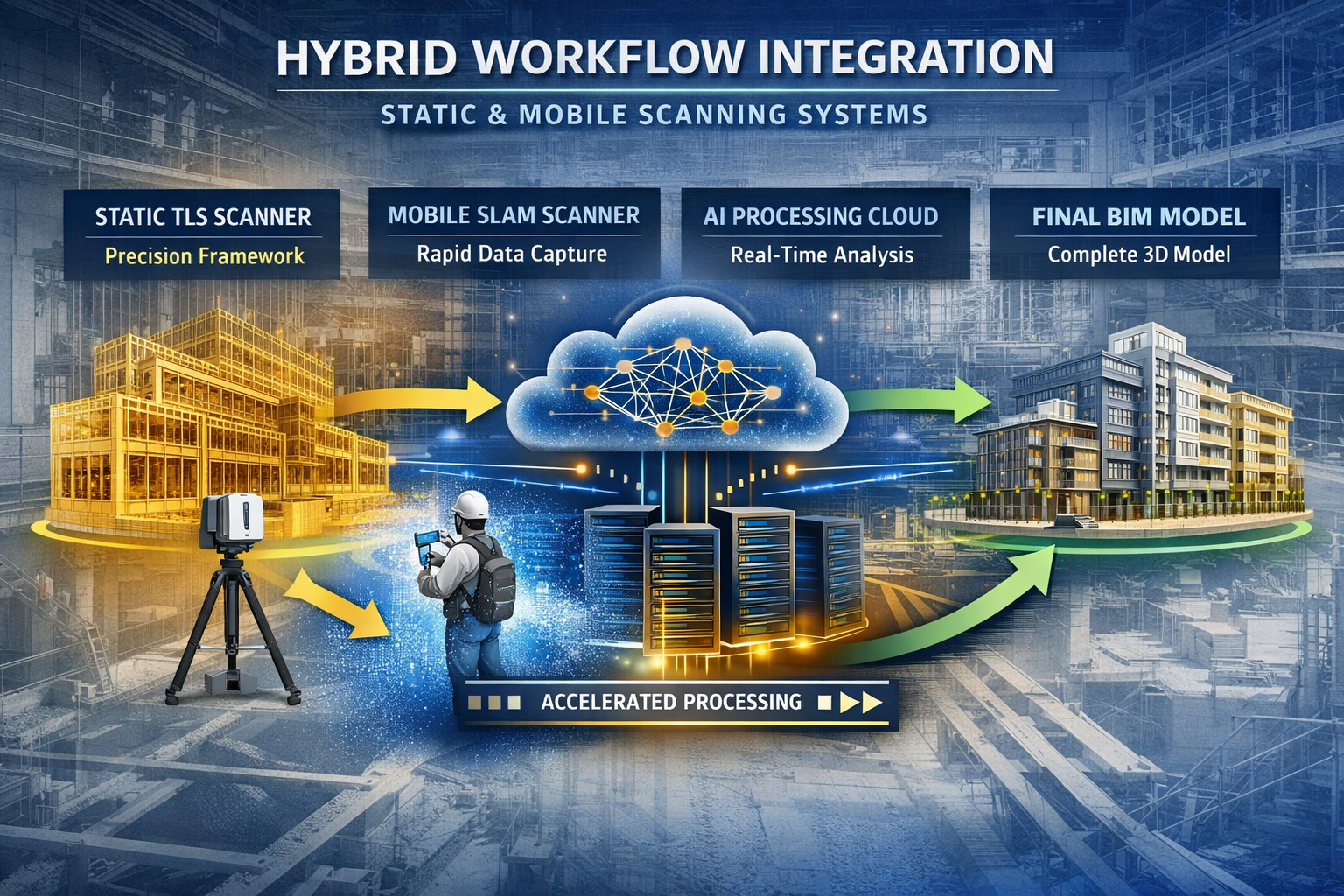
The emerging industry standard for Reality Capture Goes Mainstream: Integrating 3D Laser Scanning and Mobile Mapping in 2026 Surveys centers on hybrid workflows that leverage the strengths of multiple technologies[4]. This approach begins with establishing a precision "skeleton" using static laser scanners.
Static scanners create survey control points that serve as the geometric foundation for the entire project. Surveyors strategically position these high-precision measurements at:
- 📍 Building corners and structural grid intersections
- 📍 Floor-to-floor elevation changes
- 📍 Critical architectural features requiring exact dimensions
- 📍 Reference points for coordinate system establishment
This precision skeleton typically requires only 10-15% of total scan positions compared to a fully static approach, dramatically reducing field time while maintaining geometric integrity. The skeleton provides the accuracy framework that ensures all subsequent data collection remains geometrically consistent.
For projects involving building regulation compliance testing, this precision skeleton becomes essential for demonstrating that as-built conditions meet required tolerances.
Rapid Infill with Mobile Mapping Systems
Once the precision skeleton is established, mobile mapping systems capture the rapid "infill" data[4]. Surveyors move through spaces continuously, capturing millions of measurement points that document:
- 🏢 General building geometry and spatial relationships
- 🏢 MEP (Mechanical, Electrical, Plumbing) system routing
- 🏢 Interior finishes and architectural details
- 🏢 Furniture, fixtures, and equipment layouts
This mobile capture phase operates at remarkable speed. What might take several days with static scanning alone can be completed in hours. The mobile system automatically registers its data to the precision skeleton through common reference points, ensuring the rapid capture maintains geometric accuracy within the 15-20mm tolerance[4].
This hybrid approach proves particularly valuable for building defects surveys where comprehensive documentation is needed quickly to support remediation planning.
Standards Compliance and Quality Assurance
A critical validation point for mobile LiDAR adoption has been its compliance with industry standards. The mobile LiDAR accuracy of approximately 20mm (under 1 inch) meets BOMA 2026 standards for rentable area calculations and as-built documentation[4]. This certification has removed a significant barrier to adoption, particularly in commercial real estate where precise area calculations directly impact property valuations.
Quality assurance workflows in 2026 have evolved to support hybrid capture methodologies:
- Pre-scan planning identifies precision requirements for different project zones
- Real-time registration during field capture provides immediate feedback on data quality
- Cloud-based processing enables same-day preliminary deliverables
- AI-powered clash detection automatically identifies data gaps or inconsistencies
- Client review portals facilitate collaborative validation before final deliverables
These quality protocols ensure that the speed advantages of modern reality capture don't compromise deliverable accuracy. Professionals conducting building pathology investigations can confidently use hybrid workflows knowing their documentation meets forensic standards.
AI and Cloud Platforms: Accelerating Project Delivery and Client Collaboration
Real-Time Processing and In-Field Registration
The integration of AI-powered real-time data processing[5] represents one of the most significant advances in Reality Capture Goes Mainstream: Integrating 3D Laser Scanning and Mobile Mapping in 2026 Surveys. Modern scanning systems no longer simply collect data for later processing—they actively analyze and optimize capture while fieldwork progresses.
In-field registration has fundamentally changed project timelines. Traditional workflows required surveyors to return to the office, spend days processing and aligning scan data, then potentially return to the field to fill gaps discovered during processing. This iterative cycle could extend projects by weeks.
Today's systems perform registration automatically during capture, providing immediate visual feedback on data completeness. Surveyors can verify coverage before leaving the site, eliminating costly return visits. This capability has been instrumental in completing projects in hours that previously required days or weeks[2].
AI algorithms enhance this process through:
- 🤖 Automatic feature recognition that identifies walls, floors, ceilings, and structural elements
- 🤖 Intelligent scan planning that suggests optimal scanner positions for complete coverage
- 🤖 Noise filtering that distinguishes permanent features from temporary objects
- 🤖 Dimensional analysis that flags measurements falling outside expected tolerances
Cloud-Based Collaboration Platforms
Cloud technology has transformed how surveying professionals deliver value to clients. Rather than waiting weeks for final CAD drawings or BIM models, stakeholders can access preliminary data within hours of field capture.
Modern cloud platforms enable:
Immediate Data Sharing – Scan data uploads automatically during or immediately after field capture, making raw point clouds available for review while the survey team is still on-site.
Interactive Visualization – Clients access web-based viewers that allow them to navigate through point cloud data, take measurements, and add annotations without specialized software.
Collaborative Workflows – Multiple stakeholders (architects, engineers, contractors, facility managers) can simultaneously access and markup the same dataset, streamlining coordination.
Version Control – Cloud platforms maintain complete project history, tracking changes and allowing teams to compare conditions at different time points.
This collaborative approach proves especially valuable for complex projects like construction and condition surveys where multiple disciplines need coordinated access to as-built documentation.
Automated Deliverable Generation
AI-powered platforms increasingly automate the transformation of raw scan data into client deliverables. Machine learning algorithms trained on millions of building scans can now:
- 📊 Generate floor plans automatically from point cloud data with minimal human intervention
- 📊 Extract building information for BIM model creation
- 📊 Produce measurement reports with area calculations and dimensional schedules
- 📊 Create virtual tours with embedded measurement and annotation capabilities
These automated workflows don't eliminate the need for professional oversight—experienced surveyors still review and validate all deliverables. However, automation handles the time-consuming manual tasks, allowing professionals to focus on analysis, quality assurance, and client consultation.
The time savings are substantial. Tasks that once consumed 40-60 hours of CAD technician time can now be completed in 8-12 hours, with the professional focusing on verification rather than creation. This efficiency translates directly to faster project delivery and improved profitability.
Expanded Applications: Where Reality Capture Delivers Value in 2026
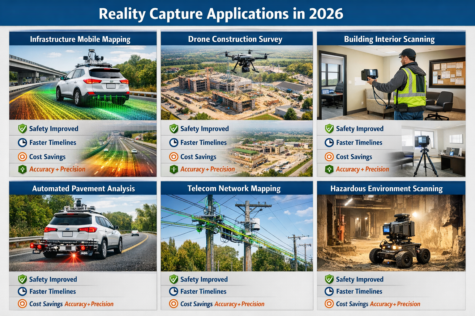
Infrastructure and Transportation Projects
Mobile mapping vehicles equipped with LiDAR have revolutionized infrastructure documentation[1]. These systems capture comprehensive data while traveling at normal traffic speeds, documenting:
- 🚗 Roadway geometry and pavement conditions
- 🚗 Telecom and fiber network infrastructure
- 🚗 Utility poles, conduits, and vaults
- 🚗 Clearance measurements and clash detection
The safety advantages are particularly significant. Automated vehicle-mounted sensors replace manual road condition assessments, eliminating worker safety risks on busy roads while reducing human error and inconsistency[1]. Survey crews no longer need to work in live traffic lanes, dramatically reducing accident exposure.
For utility companies, mobile mapping provides comprehensive asset inventories that were previously impossible to maintain. A single mapping run documents every pole, transformer, and line segment along a corridor, creating digital twins that support maintenance planning, upgrade design, and regulatory compliance.
Pavement Assessment and Asset Management
Pavement assessment has been transformed by automated sensing technology[1]. Modern systems combine:
- High-resolution cameras capturing surface imagery
- Ground-penetrating radar detecting subsurface conditions
- Laser profilers measuring rutting and roughness
- Thermal sensors identifying moisture issues
These integrated systems collect data at highway speeds, enabling transportation agencies to assess entire road networks in weeks rather than years. AI algorithms analyze the data to classify pavement conditions, predict deterioration rates, and optimize maintenance budgets.
The consistency and objectivity of automated assessment eliminates the variability inherent in manual inspections. Every section receives identical evaluation criteria, supporting defensible budget allocation and performance monitoring.
Building and Property Surveys
For building surveyors, reality capture has become an essential tool for comprehensive property documentation. When clients need to understand which building survey they need, the availability of 3D laser scanning often influences the decision toward more thorough documentation.
Modern building surveys leverage reality capture for:
Dimensional Verification – Confirming that as-built conditions match approved plans, essential for building regulation compliance.
Condition Documentation – Creating permanent records of existing conditions before renovation work, supporting party wall schedule of condition requirements.
Defect Analysis – Documenting settlement, deflection, and other structural issues with precision that supports engineering analysis.
Heritage Preservation – Recording historic structures with detail that enables accurate restoration if damage occurs.
The question of "how long does a building survey take" has changed dramatically with reality capture adoption. Field time has decreased while documentation completeness has increased—a rare win-win in professional services.
Hazardous Environment Documentation
One of the most impactful applications of modern reality capture involves enhanced safety protocols for hazardous environments[2]. Extended scanning range and autonomous/remote-controlled devices allow operators to distance themselves from hazardous environments including busy roadways, mines, tunnels, and contaminated sites[2].
Applications include:
- ⚠️ Post-disaster documentation of structurally compromised buildings
- ⚠️ Industrial facility surveys in areas with toxic materials or extreme temperatures
- ⚠️ Underground mine mapping without human entry
- ⚠️ Confined space documentation where access is dangerous or impossible
UAV technology has been particularly transformative for roof inspections and tall structure surveys. What once required scaffolding, lifts, or rope access can now be documented safely from the ground, reducing both cost and risk.
Practical Implementation: Making Reality Capture Work for Your Projects
Technology Selection Framework
Choosing the right reality capture approach requires systematic evaluation of project requirements. Consider these factors:
Accuracy Requirements – What precision do deliverables require? Survey control and structural monitoring demand static scanning precision (1.9mm), while facility documentation and area calculations work well with mobile accuracy (15-20mm)[4].
Project Scale – How large is the capture area? Mobile systems excel for large facilities where their speed advantage compounds, while static scanning remains efficient for smaller, precision-focused projects.
Site Access Constraints – How much time is available for fieldwork? Projects with limited access windows benefit from mobile capture speed, even if post-processing requires additional effort.
Deliverable Timeline – When do clients need results? Cloud-based processing and AI automation enable faster delivery from mobile data, though static scans may require less processing time overall.
Budget Considerations – What are total project economics? Remember to evaluate both field costs (where mobile saves 50-70%)[4] and processing costs (where mobile may add 20%)[4].
Building Internal Capabilities
Organizations implementing reality capture technology should develop capabilities systematically:
Training Investment – Modern systems are more user-friendly than their predecessors, but effective operation still requires training. Manufacturers typically offer comprehensive programs covering field capture, data processing, and deliverable creation.
Workflow Development – Establish standard operating procedures for different project types. Hybrid workflows require clear protocols for when to use static versus mobile capture, how to establish control networks, and quality assurance checkpoints.
Software Infrastructure – Cloud platforms require reliable internet connectivity and adequate bandwidth. Processing complex datasets demands capable workstations with appropriate graphics cards and RAM.
Client Education – Help clients understand the capabilities and limitations of different capture methods. Set realistic expectations for accuracy, deliverable types, and timelines.
Quality Management Systems
Maintaining quality in accelerated workflows requires robust systems:
- Pre-project planning that identifies accuracy requirements and optimal capture methodology
- Field verification protocols using real-time registration to confirm data completeness
- Processing standards that define acceptable noise levels, registration errors, and modeling tolerances
- Peer review procedures where experienced professionals validate deliverables before client delivery
- Continuous improvement through post-project reviews that identify opportunities to refine workflows
These systems ensure that the speed and efficiency of modern reality capture enhance rather than compromise professional standards.
Overcoming Implementation Challenges
Managing Data Volume and Processing Requirements
Modern scanning systems generate massive datasets—a single day of mobile scanning can produce hundreds of gigabytes of point cloud data. Managing this volume requires:
Storage Infrastructure – Cloud storage provides scalable capacity, but costs accumulate with data volume. Develop retention policies that archive completed projects while maintaining active project accessibility.
Processing Capacity – Point cloud processing demands substantial computing resources. Organizations can choose between investing in high-performance workstations or using cloud-based processing services that charge per project.
Data Transfer – Moving large datasets between field, office, and cloud requires adequate bandwidth. Some organizations use portable storage devices for initial transfer, then sync to cloud platforms overnight.
Addressing the Skills Gap
The transition from traditional surveying to reality capture workflows requires new skills. Organizations face choices about developing internal expertise versus outsourcing specialized tasks:
Internal Development – Investing in staff training builds long-term capability and competitive advantage. However, the learning curve can temporarily reduce productivity.
Hybrid Approach – Many firms train staff in field capture (which requires less specialized knowledge) while outsourcing complex processing and modeling to specialists.
Collaborative Partnerships – Smaller firms may partner with technology specialists who provide equipment, processing services, and expertise on a project basis.
Ensuring Client Understanding and Acceptance
Clients accustomed to traditional deliverables may need education about reality capture outputs:
Demonstrate Value – Provide interactive point cloud access that allows clients to explore data and take their own measurements. This hands-on experience builds confidence in the technology.
Explain Accuracy – Help clients understand that 15-20mm mobile accuracy is appropriate for most applications and meets industry standards[4], even though it differs from traditional survey precision.
Manage Expectations – Be clear about what reality capture can and cannot deliver. Point clouds document visible surfaces but don't reveal hidden conditions or provide material analysis.
The Future Trajectory: What's Next for Reality Capture
Continued Technology Convergence
The integration trend evident in Reality Capture Goes Mainstream: Integrating 3D Laser Scanning and Mobile Mapping in 2026 Surveys will accelerate. Future systems will seamlessly combine:
- Multiple sensor types (LiDAR, photogrammetry, thermal, GPR) in single platforms
- Real-time processing that delivers finished models rather than raw point clouds
- AI that automatically classifies building elements and detects anomalies
- Augmented reality interfaces that overlay scan data on physical environments
Democratization and Accessibility
Hardware costs will continue declining while capability increases. Smartphone-based scanning applications already provide basic reality capture functionality. While not suitable for professional surveying, these consumer tools are familiarizing the broader public with 3D documentation, creating market awareness and demand.
Professional-grade equipment will become increasingly accessible to smaller firms and independent practitioners, further democratizing the technology and expanding its application range.
Integration with Digital Twins and BIM
Reality capture will become the standard method for creating and updating digital twins—virtual replicas of physical assets that support ongoing facility management, maintenance planning, and renovation design. The connection between physical and digital will strengthen, with regular scanning updates keeping digital twins current.
BIM integration will deepen, with scan data flowing directly into design software and automated processes handling the transformation from point cloud to intelligent model. The distinction between "as-built documentation" and "design model" will blur as reality capture becomes the starting point for renovation and retrofit projects.
Regulatory and Standards Evolution
As reality capture becomes mainstream, industry standards and regulatory frameworks will evolve to formalize its use. Expect development of:
- Standardized accuracy specifications for different application types
- Quality assurance protocols for scan-based deliverables
- Professional certification programs for reality capture specialists
- Building code provisions that recognize scan-based documentation
These standards will provide clarity and confidence for both practitioners and clients, further accelerating adoption.
Conclusion: Embracing the Reality Capture Revolution
Reality Capture Goes Mainstream: Integrating 3D Laser Scanning and Mobile Mapping in 2026 Surveys represents far more than incremental technological improvement. It signals a fundamental transformation in how surveying professionals work, how quickly they deliver results, and how effectively they serve client needs.
The evidence is compelling: hybrid workflows combining static precision with mobile speed deliver optimal results across a wide range of applications[4]. AI-powered cloud platforms enable collaboration and accelerate delivery in ways impossible just years ago[5]. Enhanced safety protocols protect workers while improving data quality[2]. And perhaps most significantly, cost reductions of 50-70% in field operations[4] make comprehensive reality capture accessible to projects that could never justify traditional methods.
For surveying professionals, the path forward requires embracing these technologies while maintaining the professional judgment and quality standards that define the profession. Reality capture tools are extraordinarily powerful, but they remain tools—their value depends entirely on the expertise of the professionals who deploy them.
Actionable Next Steps
For organizations looking to implement or expand reality capture capabilities:
- Assess your project portfolio to identify where hybrid workflows would deliver the greatest value
- Invest in training that builds both technical skills and professional judgment about technology selection
- Start with pilot projects that allow learning without excessive risk
- Develop standard workflows that can be refined and scaled as experience grows
- Build client education into your sales and project kickoff processes
- Join professional communities where practitioners share experiences and best practices
- Monitor technology evolution to identify when new capabilities justify equipment upgrades
The reality capture revolution is not coming—it has arrived. The question facing surveying professionals in 2026 is not whether to adopt these technologies, but how quickly and effectively they can integrate them into their practice. Those who embrace the opportunity will find themselves delivering unprecedented value to clients while building more efficient, profitable, and satisfying professional practices.
The tools are available. The standards are established. The market is ready. The time to act is now.
References
[1] Benefits Of 3d Laser Scanning – https://eagle-eac.com/benefits-of-3d-laser-scanning/
[2] 3d Laser Scanning New Opportunities For Surveying And Mapping Professionals – https://geospatial.trimble.com/blog/geospatial/en-US/article/3d-laser-scanning-new-opportunities-for-surveying-and-mapping-professionals
[3] 3d Laser Scanning Used In Land Surveying – https://www.duncan-parnell.com/blog/108/3d-laser-scanning-used-in-land-surveying
[4] 3d Laser Scanning Vs Lidar Differences – https://iscano.com/laser-scanning-lidar-technology/3d-laser-scanning-vs-lidar-differences/
[5] The Future Of Land Surveying Technology And Upcoming Trends In 2026 – https://metricop.com/blogs/land-surveying/the-future-of-land-surveying-technology-and-upcoming-trends-in-2026
[6] 3d Laser Scanning For Property Surveys From Adoption Boom To Practical Implementation – https://nottinghillsurveyors.com/blog/3d-laser-scanning-for-property-surveys-from-adoption-boom-to-practical-implementation
[7] Navigating The 2026 Land Survey Equipment Boom Total Stations Gps And Laser Scanners Reviewed – https://nottinghillsurveyors.com/blog/navigating-the-2026-land-survey-equipment-boom-total-stations-gps-and-laser-scanners-reviewed
[8] Laser Scanning Surveys – https://www.arcsurveyors.com/laser-scanning-surveys/