The surveying industry is experiencing a seismic shift. What was once the exclusive domain of large firms with deep pockets has transformed into an accessible landscape where solo practitioners and small surveying teams can compete head-to-head with industry giants. Reality Capture Democratization: Affordable Tools Empowering Small-Firm Surveyors in 2026 Property Assessments represents more than just technological advancement—it's a fundamental restructuring of how property assessment services are delivered across the United Kingdom and beyond.
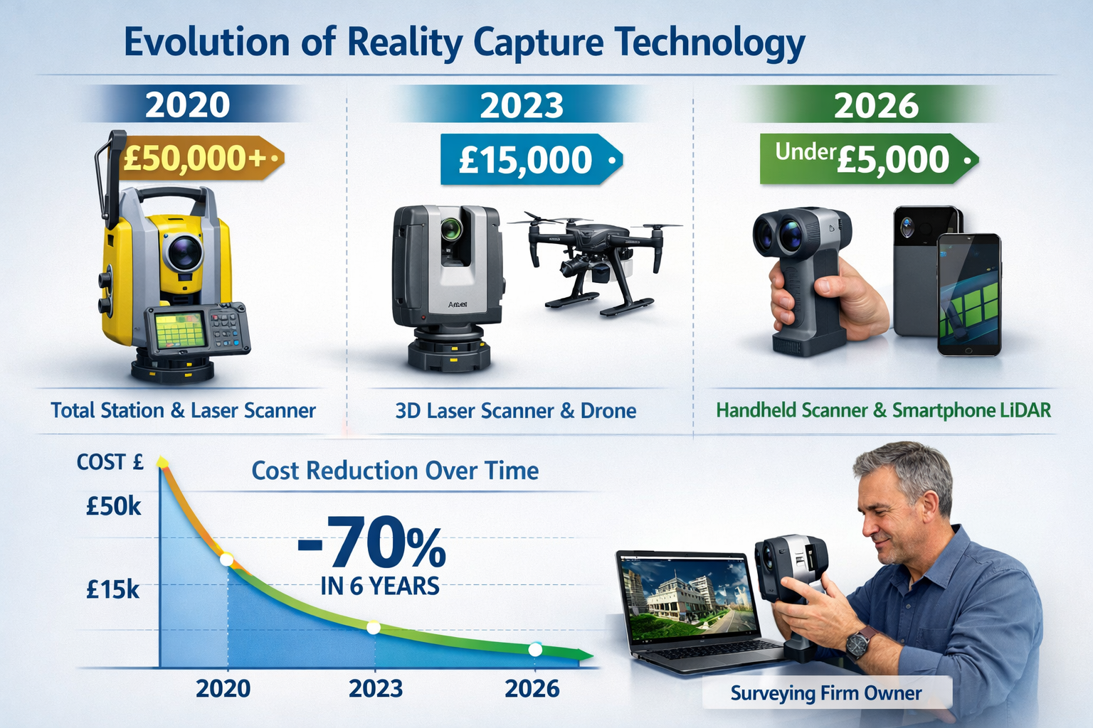
Just five years ago, acquiring professional-grade reality capture equipment meant investing £50,000 or more in total stations, terrestrial laser scanners, and specialized software licenses. Today, a small surveying practice can establish a comprehensive reality capture capability for under £10,000, accessing the same data quality and presentation standards that previously required enterprise-level resources. This transformation is reshaping competitive dynamics, client expectations, and the very definition of what constitutes a viable surveying business in 2026.
Key Takeaways
🎯 Affordable technology has leveled the playing field: Small surveying firms can now access professional reality capture tools for under £10,000, compared to £50,000+ investments required just five years ago.
⚡ Efficiency gains translate to competitive advantage: Modern reality capture reduces property assessment time by 60-70% while improving accuracy from ±50mm to ±5mm, allowing small firms to serve more clients profitably.
🔧 Integration capabilities matter more than hardware specs: Success in 2026 depends on how effectively firms integrate reality capture tools with existing workflows, client systems, and downstream applications like building surveys and valuations.
📊 Multiple business models enable adoption: Small firms can choose between equipment ownership, managed capture services, or hybrid approaches based on project volume and capital availability.
🚀 Strategic capability replaces tactical data collection: Reality capture has evolved from simple documentation to a comprehensive asset management foundation that extends value across property lifecycles.
The Technology Revolution Making Reality Capture Accessible
From Exclusive to Inclusive: The Price Transformation
The most dramatic change enabling Reality Capture Democratization: Affordable Tools Empowering Small-Firm Surveyors in 2026 Property Assessments is the collapse of entry barriers. Traditional terrestrial laser scanning systems from established manufacturers like Leica, Faro, and Trimble commanded premium prices that reflected their precision engineering and specialized markets. While these systems remain the gold standard for certain applications, the emergence of alternative technologies has created viable pathways for smaller operations.
Handheld scanning devices now deliver survey-grade accuracy at fraction of previous costs. Trimble's recent releases demonstrate this trend, with portable scanners offering ±5mm accuracy at ranges exceeding 30 meters, suitable for the majority of residential and small commercial property assessments. These devices weigh under 2kg, operate for full working days on battery power, and connect wirelessly to standard tablets—eliminating the tripod-mounted, tethered workflows that previously required dedicated operators.
Smartphone-based LiDAR technology has matured from experimental novelty to production-ready tool. Apple's integration of LiDAR sensors into iPad Pro and iPhone Pro models created an installed base of millions of capable devices. Third-party applications now leverage this hardware to capture room dimensions, generate floor plans, and create textured 3D models with accuracy sufficient for many property assessment applications. For surveyors already carrying these devices, the marginal cost of adding reality capture capability is essentially zero.
The Matterport Pro3 camera exemplifies purpose-built affordability. Capturing comprehensive 3D data at distances up to 100 meters with scan times under 20 seconds per position, this system automates measurement extraction and floor plan generation.[1] The device costs approximately £4,500—a price point accessible to sole practitioners and small partnerships. When combined with Matterport's subscription-based cloud processing and hosting (starting at £69 monthly), the total first-year investment remains under £5,500.
Software Accessibility and Cloud Processing
Hardware affordability means little without accessible software ecosystems. The 2026 landscape demonstrates remarkable maturity in this dimension. Cloud-based processing has eliminated the need for expensive workstations with specialized graphics cards. Small firms upload raw scan data to vendor platforms where automated algorithms generate point clouds, extract measurements, create floor plans, and produce client-ready deliverables—all accessible through standard web browsers.
Interoperability standards have reduced software lock-in concerns. MatterPak bundles, for example, export to industry-standard formats compatible with Revit, AutoCAD, ReCap, and 3ds Max.[1] This compatibility ensures that reality capture data integrates seamlessly with building survey workflows and client systems. Small firms no longer face the choice between proprietary ecosystems and professional credibility.
Subscription licensing models have replaced perpetual licenses with prohibitive upfront costs. Monthly or annual subscriptions for processing, storage, and collaboration platforms typically range from £50-£200 depending on project volume. This operational expense structure aligns costs with revenue, making reality capture financially viable even for firms handling just a few projects monthly.
Managed Services as Capital-Light Alternative
For practices not yet ready to invest in equipment ownership, managed capture services provide an alternative pathway. Matterport Capture Services, for instance, allows firms to "scale data collection" without hardware investment by contracting with trained operators who perform on-site scanning.[1] The surveying firm retains client relationships, project management, and analysis responsibilities while outsourcing the physical data collection.
This model proves particularly valuable for small firms testing market demand before committing capital, or for practices with seasonal fluctuations in project volume. The per-project cost structure (typically £300-£800 depending on property size and complexity) transforms reality capture from a capital investment decision into a variable cost that scales with business activity.
Practical Applications Transforming Property Assessments
Comprehensive Building Documentation
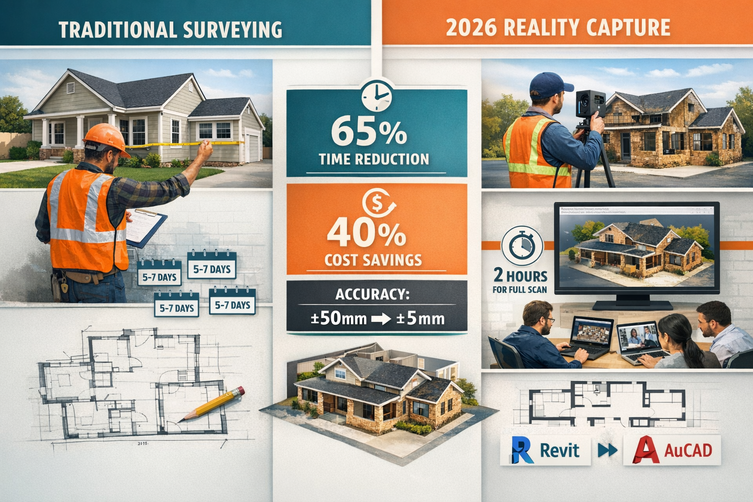
The most immediate application of Reality Capture Democratization: Affordable Tools Empowering Small-Firm Surveyors in 2026 Property Assessments is comprehensive building documentation. Traditional property surveys require extensive on-site time for manual measurements, photographic documentation, and detailed note-taking. Surveyors must ensure they capture every relevant dimension, defect, and feature during site access—returning for missed measurements means additional travel time and client coordination.
Reality capture fundamentally changes this equation. A thorough scan of a typical three-bedroom terraced house requires 45-90 minutes on-site, compared to 4-6 hours for traditional manual survey methods. The resulting 3D model preserves complete spatial relationships, allowing surveyors to extract measurements, verify dimensions, and examine details remotely weeks or months after the site visit.[1]
This capability proves invaluable for Level 3 full building surveys, where comprehensive documentation of existing conditions forms the foundation for client advice. Surveyors can revisit the digital model while writing reports, verifying observations without relying solely on field notes and photographs. Clients receive interactive 3D walkthroughs alongside traditional reports, enhancing understanding and engagement.
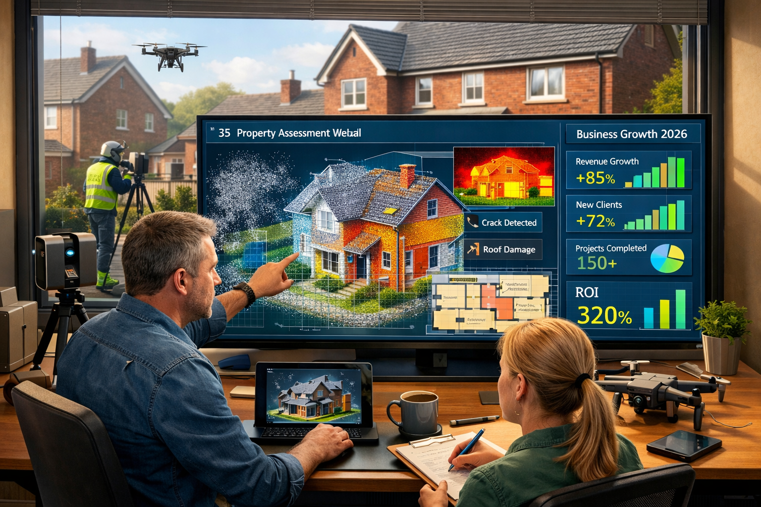
Defect Identification and Analysis
Time-stamped documentation supports quality assurance processes that identify issues when corrections remain cost-effective.[1] For property assessments, this means capturing baseline conditions that can be compared against future inspections to track deterioration, verify maintenance completion, or document changes for insurance purposes.
Small surveying firms serving residential clients can offer ongoing monitoring services—an annual or biannual scan that updates the property model and highlights changes. This recurring revenue model, previously impractical with manual survey methods, becomes economically viable when reality capture reduces site time by 60-70%.
Thermal imaging integration adds another dimension. Several affordable reality capture systems now incorporate or integrate with thermal cameras, overlaying temperature data onto 3D models. This combination reveals moisture intrusion, insulation deficiencies, and air leakage patterns invisible to visual inspection—adding diagnostic value that justifies premium pricing for building materials assessments.
Planning and Renovation Support
Property owners planning renovations need accurate existing conditions documentation before architects can design modifications. Reality capture provides this foundation efficiently. The 3D model exports to CAD and BIM platforms where designers overlay proposed changes, ensuring new elements fit existing spaces and identifying conflicts before construction begins.[1]
For small surveying firms, this creates collaboration opportunities with architects, builders, and homeowners. Offering reality capture as a standalone service or bundled with planning consultations positions the firm as a technology-enabled partner rather than a traditional measurement service provider.
Remote collaboration capabilities extend these benefits. Clients, designers, and contractors access the same 3D model through web browsers, annotating features, discussing options, and making decisions without coordinating schedules for site meetings. This asynchronous collaboration proves particularly valuable for busy professionals and investment property owners managing assets remotely.
Roof and Facade Assessments
Accessing roofs and upper facades safely requires scaffolding, cherry pickers, or specialized climbing equipment—all adding cost and complexity to traditional surveys. Drone-based reality capture has transformed this aspect of property assessment.
Affordable consumer and prosumer drones equipped with high-resolution cameras capture detailed imagery of roofs, chimneys, gutters, and upper-story facades from multiple angles. Photogrammetry software processes these images into textured 3D models with sufficient detail to identify damaged tiles, deteriorated flashings, and structural issues—all without physical access to dangerous elevations.
The cost advantage is substantial. A drone-based roof assessment typically costs £200-£400 compared to £800-£1,500 for traditional scaffolded inspection. For clients requiring roofing surveys, small firms equipped with drones and reality capture software deliver superior documentation at competitive prices.
Integration Strategies for Small-Firm Success
Beyond Technology: Organizational Frameworks
The Geo Week 2026 conference, occurring this week in Denver, Colorado, features dedicated sessions from the Reality Capture Network highlighting a crucial insight: reality capture has evolved "from a straightforward data collection method into a strategic capability reshaping planning, construction and long-term asset management across industries."[3] This evolution carries important implications for small surveying firms.
Success increasingly depends on how effectively organizations integrate tools, validate results, structure workflows and design systems—not merely on hardware specifications or software features.[3] A small firm with a £5,000 scanner and well-designed processes will outperform a competitor with £50,000 in equipment but chaotic workflows.
This organizational dimension levels the playing field further. Large firms face coordination challenges across multiple teams, offices, and legacy systems. Small practices can implement streamlined workflows more rapidly, adapting processes to client needs without navigating bureaucratic approval chains.
Workflow Design Principles
Effective integration begins with client-centric workflow design. Rather than forcing clients to adapt to new technology, successful small firms embed reality capture into existing service delivery patterns. The 3D model becomes a value-added component of traditional deliverables, not a replacement requiring client education.
For example, a building survey report maintains its familiar structure and content, but now includes a link to an interactive 3D model where clients explore the property, view annotated defects in spatial context, and share access with family members or advisors. The surveyor's professional judgment remains central; technology enhances communication and understanding.
Standardized capture protocols ensure consistency across projects and team members. Small firms should document scanning patterns, overlap requirements, lighting considerations, and quality checks. This systematization allows delegation to junior staff or contractors while maintaining output quality—essential for scaling beyond the owner's personal capacity.
Quality assurance checkpoints prevent expensive rework. Reviewing scan coverage on-site before leaving ensures no gaps exist. Cloud processing typically completes within hours, allowing next-day verification that data quality meets project requirements before scheduling reports or client presentations.
Software Integration Architecture
The Autodesk Construction Cloud and Procore integrations available with modern reality capture platforms demonstrate the importance of ecosystem connectivity.[1] Small firms serving commercial clients or working with contractors need reality capture data to flow into project management systems, collaboration platforms, and document repositories without manual file transfers and format conversions.
When evaluating reality capture solutions, small firms should prioritize platforms offering:
- Open export formats (E57, LAS, OBJ, FBX) ensuring data portability
- API access enabling custom integrations with practice management software
- Webhook notifications triggering downstream processes when scans complete
- Embedded viewers allowing client access without software installation
- Mobile applications supporting field review and annotation
These technical capabilities transform reality capture from isolated technology into an integrated component of the firm's service delivery infrastructure.
Training and Skill Development
Technology accessibility means little without operator competency. Fortunately, modern reality capture systems emphasize usability. Most devices provide real-time feedback on scan quality, coverage gaps, and data capture progress—guiding operators toward successful outcomes even during initial projects.
Manufacturer training programs have expanded to support broader adoption. Matterport, Trimble, and other vendors offer online courses, certification programs, and user communities where practitioners share techniques and troubleshoot challenges. Many programs are free or low-cost, removing another traditional barrier.
Small firms should budget 40-60 hours for initial training and practice projects before deploying reality capture on client work. This investment pays dividends through efficient field operations, quality outputs, and confident client interactions. Designating a "reality capture champion" who maintains expertise and supports other team members creates internal capability without requiring universal proficiency.
Economic Impact and Business Model Innovation
Cost-Benefit Analysis for Small Firms
The financial case for Reality Capture Democratization: Affordable Tools Empowering Small-Firm Surveyors in 2026 Property Assessments rests on three pillars: reduced field time, expanded service offerings, and enhanced client value.
Field time reduction directly impacts labor costs and capacity. A surveyor completing manual building surveys typically handles 2-3 properties weekly, depending on size and complexity. With reality capture reducing on-site time by 60-70%, that same surveyor can capture 5-7 properties weekly—more than doubling throughput without proportional cost increases.
Consider a small practice conducting 100 building surveys annually at £800 average fee (£80,000 revenue). Traditional methods require approximately 400 site hours plus 600 office hours (1,000 total). Reality capture reduces site time to 160 hours while increasing office time to 700 hours (860 total)—a 14% efficiency gain. More significantly, the reduced site time allows the same team to handle 140 surveys annually (£112,000 revenue) without adding staff.
Expanded service offerings create new revenue streams. Offering 3D documentation as a standalone service (£300-£500 for residential properties) attracts clients not requiring full surveys but needing accurate as-built documentation for renovations, insurance, or property marketing. Providing ongoing monitoring services (annual rescans at £250-£400) generates recurring revenue from existing clients.
Enhanced client value supports premium positioning. Firms offering interactive 3D models, remote collaboration capabilities, and comprehensive documentation differentiate themselves from competitors providing traditional reports only. This differentiation justifies 15-25% price premiums while improving client satisfaction and referral rates.
Investment Recovery Timeline
A typical small-firm reality capture investment includes:
| Item | Cost |
|---|---|
| Matterport Pro3 Camera | £4,500 |
| Annual Software Subscription | £1,200 |
| Drone (DJI Mini 3 Pro) | £800 |
| Training and Practice | £500 |
| Marketing Materials | £300 |
| Total First Year | £7,300 |
With increased capacity supporting 40 additional surveys annually at £800 each (£32,000 additional revenue) and gross margins of 60% (£19,200 contribution), the investment recovers in under five months. Subsequent years require only the £1,200 subscription (recovered in three weeks), making reality capture one of the highest-ROI investments available to small surveying practices.
Competitive Positioning Strategies
Small firms leveraging Reality Capture Democratization: Affordable Tools Empowering Small-Firm Surveyors in 2026 Property Assessments can compete through several positioning strategies:
Technology-enabled boutique: Position as a modern, innovative practice delivering superior documentation and client experience. Target tech-savvy clients, investment property owners, and professionals who value efficiency and digital access. Premium pricing reflects enhanced value, not just survey completion.
Efficiency specialist: Compete on turnaround time and responsiveness. Reality capture's reduced site time enables same-week or next-week service delivery that larger firms with complex scheduling cannot match. Target time-sensitive transactions and clients prioritizing speed.
Collaboration partner: Emphasize integration with architects, contractors, and designers. Reality capture's interoperability makes the surveying firm a valuable team member on renovation and development projects. Target repeat clients with ongoing property portfolios.
Niche market focus: Apply reality capture to specialized property types where traditional methods prove particularly inefficient—heritage buildings requiring non-contact documentation, complex roof structures, multi-unit residential buildings, or commercial properties with occupied spaces limiting access times.
Overcoming Implementation Challenges
Technical Obstacles and Solutions
Despite significant advances in accessibility, small firms still encounter technical challenges when implementing reality capture capabilities. GPS-denied environments like building interiors require alternative positioning methods. Modern systems address this through visual odometry, inertial measurement units, and feature-matching algorithms that maintain accuracy without satellite signals.
Large file sizes can overwhelm standard internet connections and storage systems. A comprehensive scan of a 2,000 square foot property generates 2-5GB of raw data. Cloud processing platforms address this through background uploads, compression algorithms, and progressive loading that enables remote access before complete file transfers finish.
Lighting variability affects data quality, particularly for photogrammetry-based systems. Overcast days provide ideal outdoor conditions, but interior spaces with mixed natural and artificial lighting create challenges. Small firms should develop lighting protocols—supplemental LED panels, HDR capture modes, or time-of-day scheduling—that ensure consistent results across varying conditions.
Accuracy validation concerns clients accustomed to traditional survey methods with established precision standards. Reality capture systems should be periodically verified against known dimensions using calibrated reference objects or control points. Documenting these validation procedures builds client confidence and supports professional standards compliance.
Client Education and Change Management
Introducing reality capture requires client education. Many property owners, solicitors, and lenders remain unfamiliar with 3D documentation and may question its equivalence to traditional surveys. Small firms should develop clear communication materials explaining:
- How reality capture enhances accuracy and completeness
- What the 3D model shows and how to navigate it
- Why reduced site time doesn't compromise quality
- How digital documentation supports downstream uses
Offering hybrid deliverables—traditional PDF reports plus 3D models—eases the transition. Clients receive familiar documentation while gaining access to enhanced digital resources. Over time, as comfort with 3D models grows, firms can emphasize digital-first delivery with traditional reports as secondary outputs.
Demonstration projects build confidence. Offering reality capture at no additional charge on initial projects for key clients (estate agents, solicitors, property developers) creates advocates who refer additional work and validate the approach to skeptical peers.
Regulatory and Professional Standards Compliance
Professional surveying bodies including RICS (Royal Institution of Chartered Surveyors) have developed guidance on reality capture use in property assessments. Small firms must ensure their implementation aligns with these standards, particularly regarding:
-
Competency requirements: Surveyors remain responsible for professional judgments regardless of technology used. Reality capture doesn't replace expertise—it enhances documentation supporting expert analysis.
-
Metadata documentation: Scan parameters, equipment specifications, accuracy estimates, and capture dates should be recorded and available for review, similar to traditional survey field notes.
-
Data security and privacy: 3D models containing detailed property information require appropriate security measures, particularly for occupied residential properties. Encryption, access controls, and retention policies should align with GDPR and professional standards.
-
Insurance coverage: Professional indemnity policies should explicitly cover reality capture activities. Some insurers require notification or charge additional premiums for drone operations or technology-based services.
Working with chartered surveyors experienced in reality capture implementation can help small firms navigate these regulatory considerations effectively.
Future Trajectory and Strategic Considerations
Emerging Capabilities on the Horizon
The trajectory of Reality Capture Democratization: Affordable Tools Empowering Small-Firm Surveyors in 2026 Property Assessments continues toward greater accessibility and capability. Several emerging trends will further empower small firms:
Artificial intelligence integration will automate defect detection, measurement extraction, and report generation. Early implementations already identify common issues like cracks, moisture stains, and structural deformation from point cloud data. As these algorithms mature, they'll provide decision support that augments surveyor expertise rather than replacing professional judgment.
Augmented reality visualization will enable on-site overlay of historical scans, proposed modifications, or hidden building systems onto physical views through tablets or AR glasses. This capability supports client consultations, contractor coordination, and field verification with unprecedented clarity.
Continuous monitoring systems using permanently installed sensors will complement periodic scanning, tracking building movement, environmental conditions, and system performance between formal assessments. Small firms can offer monitoring services that generate recurring revenue while providing clients with early warning of developing issues.
Blockchain-based documentation may provide tamper-evident records of building conditions, supporting insurance claims, warranty disputes, and property transactions with verifiable historical data. Early movers establishing expertise in authenticated reality capture documentation will position themselves advantageously as these applications mature.
Strategic Investment Decisions
Small firms should approach reality capture as a strategic capability requiring ongoing investment rather than a one-time technology purchase. Annual budgets should include:
- Software and subscription renewals (£1,200-£2,400)
- Equipment updates and additions (£500-£1,500)
- Training and skill development (£300-£800)
- Marketing and client education (£400-£1,000)
This £2,400-£5,700 annual investment maintains competitive positioning and ensures the firm benefits from continuous improvements in processing algorithms, integration capabilities, and feature additions that vendors deliver through subscription models.
Partnership strategies can accelerate capability development. Collaborating with complementary specialists—structural engineers, architects, or building contractors—creates referral networks where each party leverages reality capture for their specific applications. These partnerships distribute investment costs while expanding market reach.
Market Positioning for Long-Term Success
As reality capture becomes standard practice rather than differentiating innovation, small firms must evolve their positioning. The competitive advantage shifts from "we offer 3D scanning" to "we deliver superior insights through integrated technology and deep expertise."
This evolution emphasizes interpretation over documentation. Clients can increasingly access basic reality capture through multiple providers, including managed services and automated platforms. The enduring value lies in professional judgment—identifying significant defects, assessing structural implications, recommending remediation priorities, and advising on property valuations.
Small firms should develop specialized expertise in particular property types, construction methods, or defect categories where their knowledge creates genuine value. Reality capture becomes the documentation foundation supporting that expertise, not the expertise itself.
Client relationship depth provides sustainable competitive advantage. Technology democratization means multiple firms can deliver similar technical outputs. Firms that understand client businesses, anticipate needs, and provide proactive advice—supported by comprehensive reality capture documentation—build loyalty that transcends price competition.
Implementation Roadmap for Small Surveying Firms
Phase 1: Assessment and Planning (Weeks 1-4)
Evaluate current practice capabilities and gaps. Document typical project types, volumes, pricing, and profit margins. Identify where reality capture would reduce costs, expand capacity, or enable new services. Review client feedback for unmet needs that reality capture might address.
Research available solutions matching practice requirements and budget. Request demonstrations from vendors, speak with existing users in similar practices, and evaluate integration with current software and workflows. Consider both equipment purchase and managed service options.
Develop business case quantifying investment requirements, expected benefits, and recovery timeline. Present to partners or stakeholders for approval, ensuring alignment on implementation approach and resource allocation.
Establish success metrics defining how the firm will measure reality capture impact. Typical metrics include: projects completed per surveyor per month, average site time per project, client satisfaction scores, premium pricing achievement, and new service revenue.
Phase 2: Acquisition and Training (Weeks 5-12)
Purchase or contract for equipment and services. Negotiate favorable terms, particularly for software subscriptions where annual commitments may offer discounts. Ensure all necessary accessories, batteries, and support items are included.
Complete manufacturer training programs for designated staff. Supplement with practice projects on firm-owned properties, staff homes, or pro-bono community projects that provide learning opportunities without client risk.
Develop standard operating procedures documenting capture protocols, quality checks, data management, and client delivery workflows. Create templates for client communications, project proposals, and deliverable formats.
Update marketing materials and website highlighting reality capture capabilities. Develop case studies, sample outputs, and educational content explaining benefits to target clients. Consider creating a building survey guide incorporating reality capture advantages.
Phase 3: Pilot Implementation (Weeks 13-24)
Launch with selected clients who are technology-receptive and likely to provide constructive feedback. Offer introductory pricing or value-added services to encourage adoption and build case studies.
Document lessons learned from each project. What worked well? What challenges emerged? How did clients respond? What workflow adjustments would improve efficiency or quality?
Refine processes based on pilot experience. Update standard operating procedures, adjust pricing, and enhance client communication approaches. Identify additional training needs or equipment requirements.
Gather testimonials and results from pilot clients. Document time savings, enhanced insights, or other benefits that support marketing to broader client base.
Phase 4: Full Deployment (Weeks 25+)
Integrate reality capture into standard service offerings. Make 3D documentation a default component of appropriate survey types rather than an optional add-on, reflecting its efficiency advantages and client value.
Expand market reach through targeted marketing emphasizing technology-enabled capabilities. Develop relationships with estate agents, solicitors, and property professionals who refer survey work.
Monitor performance metrics against targets established in Phase 1. Adjust strategies based on actual results, market response, and competitive dynamics.
Plan next-phase enhancements as the firm gains experience and market conditions evolve. Consider specialized applications, additional equipment, or expanded service offerings that build on established reality capture foundation.
Conclusion: Embracing the Democratization Opportunity
Reality Capture Democratization: Affordable Tools Empowering Small-Firm Surveyors in 2026 Property Assessments represents a genuine inflection point in the surveying profession. The barriers that once protected large firms with capital resources have fallen, creating unprecedented opportunities for small practices willing to embrace change.
The technology has matured beyond early-adopter experimentation into production-ready systems delivering reliable results at accessible price points. The software ecosystems have evolved to support integration with existing workflows and client systems. The market has developed awareness and appreciation for enhanced documentation that reality capture provides.
Small surveying firms face a strategic choice: lead the transition to technology-enabled service delivery, or risk competitive displacement by more agile competitors. The investment required—both financial and organizational—remains modest relative to potential returns. The learning curve, while real, is manageable through available training resources and supportive vendor communities.
Success requires more than equipment purchase. It demands thoughtful workflow design, consistent quality processes, effective client communication, and ongoing skill development. Firms approaching reality capture as a strategic capability rather than a tactical tool will realize the greatest benefits.
The democratization of reality capture doesn't eliminate the need for professional expertise—it amplifies its impact. Surveyors who combine deep knowledge of building pathology, construction methods, and property markets with comprehensive digital documentation capabilities will deliver unprecedented value to clients. Small firms with this combination can compete effectively against any competitor, regardless of size.
Actionable Next Steps
For small surveying firms ready to embrace this opportunity:
-
Schedule vendor demonstrations from Matterport, Trimble, and other reality capture providers this month. Experience the technology firsthand and evaluate fit with your practice.
-
Connect with peers already using reality capture. Join online communities, attend webinars, or arrange informal consultations with non-competing firms in other regions who can share implementation lessons.
-
Develop your business case using the framework outlined in this article. Quantify the investment, project the benefits, and establish the metrics that will demonstrate success.
-
Identify pilot clients who would benefit from enhanced documentation and are willing to provide feedback on new service delivery approaches.
-
Commit to the transition. Reality capture democratization creates opportunities for those who act decisively. The competitive landscape in 2027 will favor firms that established capability in 2026.
The tools are available. The business case is compelling. The market is ready. The question for small-firm surveyors is not whether to adopt reality capture, but how quickly they can implement it effectively. Those who answer that question with urgency and commitment will shape the future of property assessment services.
For firms seeking guidance on integrating reality capture with traditional building survey services, working with experienced chartered surveyors who have successfully navigated this transition can accelerate implementation and avoid common pitfalls. The democratization of reality capture ensures that professional expertise, not capital resources, determines competitive success in 2026 and beyond.
References
[1] 10 Ways 3d Scanner Technology Leads Efficiencies Surveying – https://matterport.com/blog/10-ways-3d-scanner-technology-leads-efficiencies-surveying
[2] Reality Capture Goes Mainstream Accessible Tools Transforming Property Surveys In 2026 – https://nottinghillsurveyors.com/blog/reality-capture-goes-mainstream-accessible-tools-transforming-property-surveys-in-2026
[3] Geo Week 2026 Highlights Reality Capture S Strategic Role – https://www.gim-international.com/content/news/geo-week-2026-highlights-reality-capture-s-strategic-role