nn
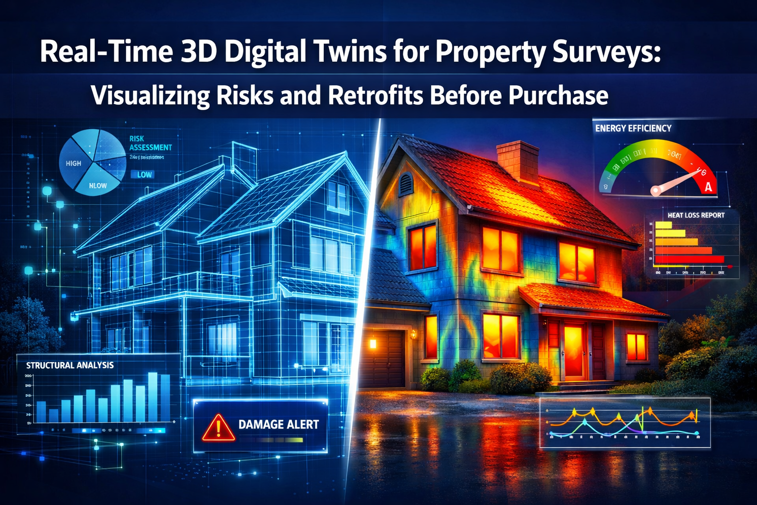
Imagine standing in an estate agent's office, but instead of flipping through static photographs and paper reports, you're exploring a living, breathing digital replica of your potential new home. You can peel back walls to inspect the plumbing, simulate a flood to see where water would pool, or test different insulation upgrades to calculate exact energy savings—all before making an offer. This isn't science fiction. In 2026, Real-Time 3D Digital Twins for Property Surveys: Visualizing Risks and Retrofits Before Purchase are transforming how homebuyers, investors, and property professionals assess real estate.
Traditional property surveys have relied on written reports, photographs, and the surveyor's expertise to identify potential issues. While valuable, these methods often leave buyers guessing about the true extent of problems and the cost of remediation. Digital twin technology changes everything by creating interactive, data-rich 3D models that update in real-time with survey findings, sensor data, and predictive analytics. This revolutionary approach empowers buyers to negotiate confidently, plan renovations accurately, and avoid costly surprises after purchase.
Key Takeaways
✅ Real-time visualization: Digital twins create interactive 3D property models that display structural issues, energy performance, and environmental risks instantly, replacing static survey reports with dynamic, explorable assets.
✅ Cost savings and revenue growth: Research shows digital twin technology can reduce labor costs by up to 10 percent and increase revenue by up to 5 percent through better decision-making and efficiency gains.
✅ Predictive risk modeling: Buyers can simulate natural disasters, test retrofit scenarios, and calculate exact ROI before purchase, enabling data-driven negotiations and confident investment decisions.
✅ Collaborative cloud platforms: Cloud-based digital twin systems enable surveyors, engineers, architects, and buyers to review findings simultaneously, accelerating the pre-purchase assessment process significantly.
✅ Accessible technology: Advanced drone surveys, mobile 3D mapping, and user-friendly platforms are making digital twin property assessments increasingly affordable and practical for residential buyers in 2026.
Understanding Digital Twin Technology in Property Surveying
What Are Digital Twins?
A digital twin is a virtual replica of a physical asset that mirrors its real-world counterpart in real-time. In property surveying, digital twins combine multiple data sources—drone imagery, laser scanning, thermal imaging, moisture sensors, and historical records—into a single, interactive 3D model. Unlike traditional building surveys that produce static documents, digital twins are living databases that can be updated, analyzed, and manipulated to answer "what if" questions.
The technology behind Real-Time 3D Digital Twins for Property Surveys: Visualizing Risks and Retrofits Before Purchase relies on several key components:
- Reality capture: Drones, laser scanners, and mobile mapping systems collect precise spatial data about the property's physical condition
- Data integration: Information from multiple sensors and sources merges into a unified 3D model
- Cloud computing: Powerful servers process massive datasets and enable real-time collaboration
- Visualization engines: Software renders the data into explorable 3D environments accessible via browsers or specialized applications
- Analytics platforms: AI and machine learning algorithms identify patterns, predict failures, and recommend interventions
How Digital Twins Differ from Traditional Survey Methods
Traditional property surveys, including comprehensive Level 3 building surveys, rely heavily on the surveyor's physical inspection, written descriptions, and 2D photographs. While thorough, these methods have limitations:
| Traditional Surveys | Digital Twin Surveys |
|---|---|
| Static written reports | Interactive 3D models |
| Single point-in-time assessment | Continuous monitoring capability |
| Limited visualization of hidden issues | X-ray vision into walls, foundations, systems |
| Difficult to share and collaborate | Cloud-based instant access for all stakeholders |
| Retrofit planning requires imagination | Visual simulation of proposed changes |
| Manual measurements and calculations | Automated measurements with millimeter accuracy |
The shift toward digital twins doesn't replace the expertise of chartered surveyors—it amplifies it. Professional judgment remains essential for interpreting findings and providing recommendations. However, the technology provides surveyors with unprecedented tools to communicate their findings clearly and help clients understand complex issues.
The Evolution of Property Survey Technology in 2026
The property surveying industry has undergone remarkable transformation over the past decade. Advanced drone survey technology now captures highly detailed property information that previously required multiple on-site visits, significantly reducing surveying timelines and costs.[1]
Single-flight data capture has replaced the need for surveyors to make repeated visits to measure different aspects of a property. Multi-sensor drones equipped with RGB cameras, thermal imaging, LiDAR scanners, and multispectral sensors can collect comprehensive data in a single session.[1] For clients with agricultural, commercial, or development-scale properties, these capabilities provide clarity and detail that simply didn't exist a decade ago.
Perhaps most impressive is the emergence of autonomous drone capabilities with predictive modeling. Flight paths can now be automatically planned using predictive modeling, and drones can autonomously adjust altitude, angle, and sensor selection to achieve optimal readings—a breakthrough capability that has matured significantly in 2026.[1]
Reality capture technology is also becoming increasingly democratized through new user-friendly tools that enable more comprehensive data collection and in-field treatment for faster decision-making, including capture from mobile phones and mobile mapping systems.[5] This accessibility means that even smaller surveying firms can offer digital twin capabilities to residential buyers.
Real-Time 3D Digital Twins for Property Surveys: Visualizing Risks and Retrofits Before Purchase
Identifying Structural Risks Through Interactive Visualization
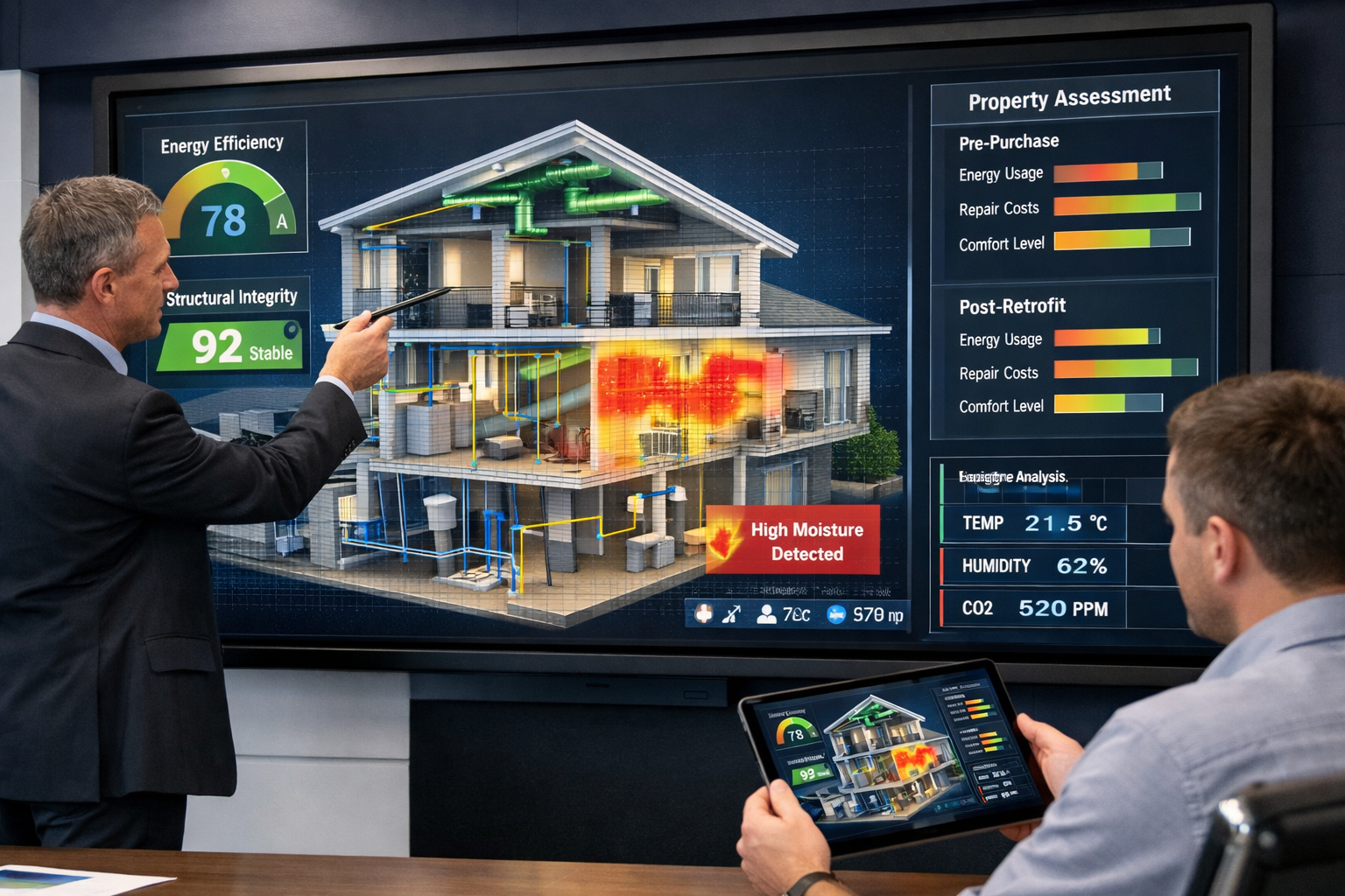
One of the most powerful applications of Real-Time 3D Digital Twins for Property Surveys: Visualizing Risks and Retrofits Before Purchase is the ability to identify and understand structural issues before committing to a purchase. Traditional survey reports might describe foundation cracks, roof deterioration, or wall movement in text, but digital twins allow buyers to see exactly where problems exist and understand their severity in context.
When a surveyor conducts a property inspection using digital twin technology, structural concerns are mapped directly onto the 3D model with color-coded severity indicators:
🔴 Critical issues requiring immediate attention (structural instability, major water ingress)
🟠 Significant defects needing repair within 12 months (roof damage, deteriorating damp-proof courses)
🟡 Moderate concerns to address during ownership (minor cracks, aging systems)
🟢 Maintenance items for long-term planning (redecorating, gutter cleaning)
This visual hierarchy helps buyers prioritize concerns and understand the financial implications at a glance. The digital twin can also display cross-sections through walls and floors, revealing hidden structural elements, cavity wall conditions, and the extent of timber frame damage that wouldn't be visible in photographs.
For older properties with common defects, the ability to visualize issues in 3D context is invaluable. Buyers can see how subsidence affects multiple areas of a building, understand the relationship between roof problems and interior water damage, or identify patterns of deterioration that suggest underlying causes.
Energy Performance and Environmental Impact Modeling
Beyond structural assessment, digital twins excel at simulating energy performance and environmental impacts. By integrating thermal imaging data, building material properties, and local climate information, the system can calculate:
- Heat loss patterns through walls, windows, roofs, and floors
- Current energy efficiency ratings based on actual conditions, not theoretical calculations
- Carbon footprint of the property's current heating and cooling systems
- Predicted utility costs under different usage scenarios
- Impact of proposed retrofits on energy consumption and costs
This capability transforms how buyers approach energy efficiency. Instead of relying on outdated Energy Performance Certificates (EPCs) that may not reflect the property's actual condition, buyers can see real-time thermal imaging overlaid on the 3D model, showing exactly where heat escapes and cold spots exist.
The digital twin can then simulate various retrofit scenarios:
Scenario A: Install double-glazed windows (£8,000 investment)
Projected annual savings: £420 | Payback period: 19 years | Carbon reduction: 0.8 tonnes CO₂/year
Scenario B: Upgrade insulation in loft and walls (£6,500 investment)
Projected annual savings: £680 | Payback period: 9.5 years | Carbon reduction: 1.4 tonnes CO₂/year
Scenario C: Install air-source heat pump and solar panels (£18,000 investment)
Projected annual savings: £1,250 | Payback period: 14.4 years | Carbon reduction: 3.2 tonnes CO₂/year
These calculations are based on the property's actual dimensions, materials, orientation, and local energy prices, providing far more accurate projections than generic estimates. Buyers can make informed decisions about which improvements offer the best return on investment and align with their environmental goals.
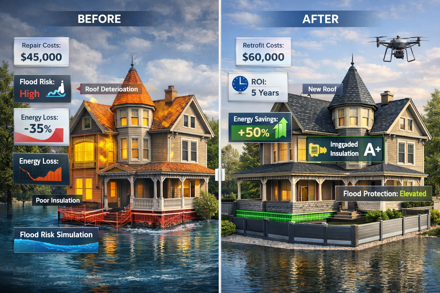
Natural Disaster and Climate Risk Simulation
Climate change has made understanding environmental risks essential for property buyers. Digital twins enable property owners and developers to model how buildings and infrastructure would perform during flooding, hurricanes, and other natural disasters before purchase or retrofitting decisions are made.[2]
This predictive capability is already being used in commercial settings. A German clothing company is currently using digital twins to map flooding risks across its supplier network in real time.[2] The same technology is now available for residential property assessment.
For a property in a flood-prone area, the digital twin can:
- Simulate flood scenarios at different water levels (1-in-10 year, 1-in-100 year, 1-in-1000 year events)
- Show which rooms and systems would be affected at each level
- Calculate potential damage costs based on the property's contents and finishes
- Evaluate flood defense options (barriers, raised electrical systems, water-resistant materials)
- Model drainage improvements and their effectiveness
Similarly, for properties in areas prone to extreme weather, the digital twin can simulate:
- Wind loading on roofs and external structures during storm conditions
- Snow accumulation and structural stress on flat or low-pitched roofs
- Ground movement risks from subsidence, landslides, or soil expansion
- Wildfire exposure and defensible space requirements
This level of risk visualization empowers buyers to make informed decisions about whether a property's location is acceptable, what insurance costs might be, and what mitigation measures would be necessary. When considering environmental issues during a building survey, digital twins provide unprecedented clarity.
Retrofit Planning and Cost Estimation
One of the most practical applications of Real-Time 3D Digital Twins for Property Surveys: Visualizing Risks and Retrofits Before Purchase is retrofit planning. Buyers can experiment with different renovation scenarios within the digital model, seeing exactly how changes would look and calculating precise costs before making an offer.
The digital twin allows users to:
Visualize design changes: Knock down walls, add extensions, reconfigure room layouts, and see the results in realistic 3D rendering
Test structural modifications: Understand which walls are load-bearing, where steel beams would be required, and how changes affect the building's integrity
Calculate material quantities: Automatically measure square footage for flooring, wall areas for painting, roof areas for replacement, and generate accurate material lists
Estimate costs: Integrate with construction cost databases to provide real-time pricing for proposed changes based on current market rates
Assess planning requirements: Identify which modifications would require planning permission or building regulation approval
This capability is particularly valuable when negotiating house prices based on survey findings. Instead of making vague requests for price reductions due to "various defects," buyers can present precise cost estimates for necessary repairs and improvements, backed by data from the digital twin.
For example, a buyer might discover through the digital twin that:
- Rewiring the entire property will cost £7,200 (based on exact cable runs and outlet locations)
- Replacing the roof requires 142 square meters of tiles at £85/m² plus £4,500 labor
- Damp-proofing the basement needs £3,800 in materials and specialist treatment
- Total remediation cost: £22,300
Armed with this specific information, the buyer can negotiate a price reduction that reflects the actual work required, rather than guessing or accepting the seller's estimates.
The Technology Stack Behind Real-Time Digital Twins
Data Capture Methods and Equipment
Creating accurate digital twins requires sophisticated data capture equipment and techniques. In 2026, several technologies work together to build comprehensive property models:
🚁 Drone Photogrammetry and LiDAR
Modern drone surveys use multiple sensors simultaneously to capture exterior conditions. RGB cameras take hundreds of overlapping photographs that are stitched together using photogrammetry software to create detailed 3D models. LiDAR (Light Detection and Ranging) sensors emit laser pulses that measure distances with millimeter precision, creating accurate point clouds of the property's exterior surfaces, roof condition, and surrounding terrain.[1]
Multi-sensor drones can also carry thermal imaging cameras to identify heat loss, moisture intrusion, and insulation deficiencies from the air. This capability is particularly valuable for large properties, commercial buildings, and sites with difficult access.
📱 Mobile 3D Mapping
Interior spaces are captured using mobile mapping systems—handheld devices or smartphone-based applications that use simultaneous localization and mapping (SLAM) technology. As the surveyor walks through the property, the device captures spatial data, photographs, and measurements, building a 3D model in real-time.[7]
This technology has become remarkably accessible. Professional-grade mobile mapping can now be performed with tablets or smartphones equipped with LiDAR sensors, making it practical for routine residential surveys. The captured data integrates seamlessly with exterior drone data to create a complete interior-exterior digital twin.
🔬 Specialist Sensors and Testing Equipment
Beyond basic spatial capture, digital twins incorporate data from specialized sensors:
- Thermal imaging cameras detect temperature variations indicating insulation problems, moisture, and air leakage
- Moisture meters identify damp conditions in walls, floors, and timbers
- Structural sensors measure movement, vibration, and load distribution
- Air quality monitors detect radon, carbon monoxide, and volatile organic compounds
- Acoustic sensors assess sound insulation and identify noise transmission paths
This sensor data is georeferenced—linked to specific locations in the 3D model—so issues are visualized exactly where they occur.
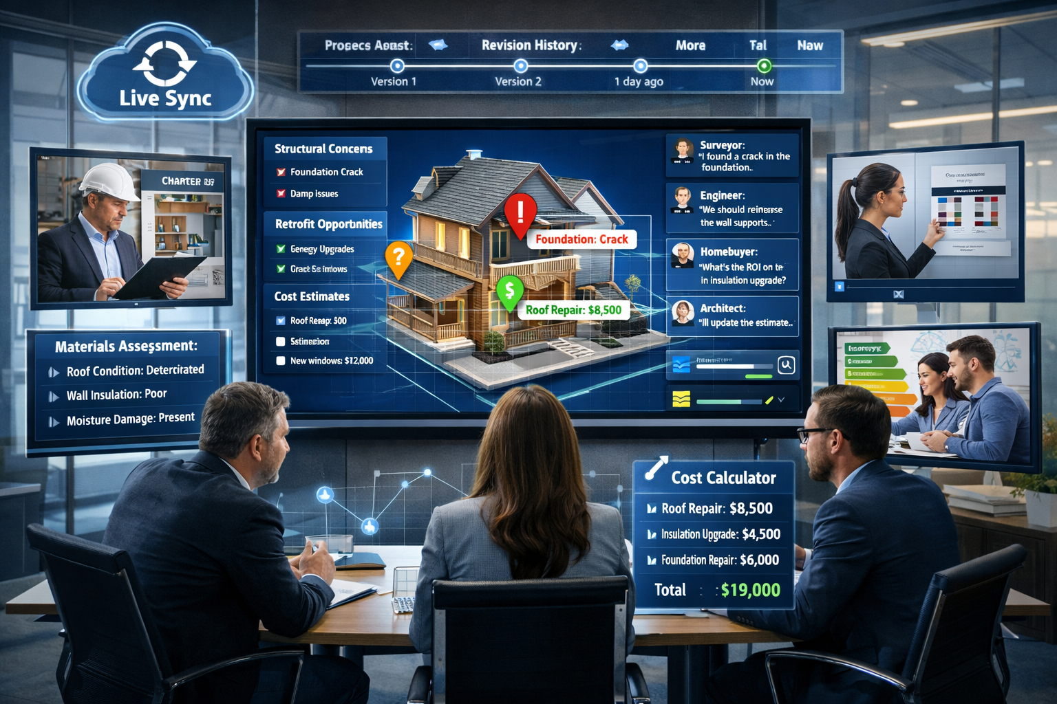
Cloud-Based Platforms and Collaboration Tools
The power of Real-Time 3D Digital Twins for Property Surveys: Visualizing Risks and Retrofits Before Purchase comes from cloud-based platforms that transform raw data into actionable insights. As of 2026, these platforms enable instant file sharing, 3D visualization in browsers, real-time revision syncing, and integrated communication with engineers and architects—transforming deliverables from static documents to interactive, collaborative assets.[1]
Several commercial platforms facilitate digital twin creation for property assessment:
Autodesk Construction Cloud turns construction sites into digital models for planning and management, with tools for reality capture, model coordination, and issue tracking.[2]
Cupix creates 3D models using drones and laser scanners, with particular strength in converting 2D floor plans into explorable 3D environments.[2]
Matterport produces lifelike 3D models for real estate, construction, and facility management, with an emphasis on photorealistic visualization and virtual tours.[2]
These platforms share common features that make digital twins practical for property surveys:
✔️ Browser-based access: No special software installation required—buyers can explore models on any device
✔️ Annotation tools: Surveyors can mark issues directly on the 3D model with notes, photos, and severity ratings
✔️ Measurement tools: Users can measure distances, areas, and volumes with a few clicks
✔️ Collaboration features: Multiple stakeholders can view and comment simultaneously
✔️ Version control: Changes and updates are tracked, creating an audit trail of the property's assessment
✔️ Integration capabilities: Digital twins can connect with cost databases, scheduling tools, and project management systems
Artificial Intelligence and Predictive Analytics
The latest advancement in digital twin technology is the integration of artificial intelligence to automate defect detection and predict future problems. Machine learning algorithms trained on thousands of property surveys can now:
🤖 Automatically identify common defects: Cracks, dampness, roof damage, and deterioration patterns are flagged without manual inspection
🤖 Predict maintenance needs: Based on material age, condition, and environmental factors, AI estimates when systems will require replacement
🤖 Recommend prioritization: Algorithms rank issues by urgency, safety impact, and cost-effectiveness of remediation
🤖 Estimate costs: AI-powered cost databases provide instant estimates for repairs and improvements based on local market rates
🤖 Assess compliance: Automated checks identify potential violations of building regulations, planning restrictions, and statutory considerations
GIS-centric asset lifecycle management is being redefined by AI and real-time spatial insights, resulting in easier real-time collaboration, smarter decision-making, reduced risk, and enhanced efficiency throughout an asset's lifecycle.[5]
These AI capabilities don't replace professional surveyors—they augment their expertise, allowing them to focus on complex judgments while automation handles routine pattern recognition. The combination of human expertise and machine intelligence produces more thorough, consistent, and reliable property assessments.
Practical Applications for Homebuyers and Property Investors
Pre-Purchase Due Diligence and Negotiation
For homebuyers, the primary value of Real-Time 3D Digital Twins for Property Surveys: Visualizing Risks and Retrofits Before Purchase lies in informed decision-making during the purchase process. Understanding what questions to ask during a building survey becomes easier when you can explore the property virtually and see issues firsthand.
The digital twin enables buyers to:
Conduct remote assessments: Explore the property in detail from anywhere, reducing the need for multiple site visits
Involve remote experts: Share the model with family members, contractors, or consultants who can't visit in person
Compare properties objectively: Evaluate multiple properties side-by-side using standardized metrics and visualizations
Understand true condition: See beyond cosmetic presentation to identify underlying structural and systems issues
Calculate accurate budgets: Plan renovation costs precisely before making an offer
Negotiate from strength: Present data-driven evidence when requesting price reductions or seller remediation
This transparency fundamentally changes the power dynamic in property transactions. Sellers can no longer rely on information asymmetry—buyers have access to the same detailed condition data that professionals use.
Investment Property Analysis and Portfolio Management
For property investors, digital twins provide sophisticated tools for portfolio analysis and management. When evaluating potential investment properties, digital twins enable:
📊 Rapid condition assessment: Quickly identify properties with good bones versus those requiring extensive work
📊 Accurate renovation budgeting: Calculate precise costs for improvements that will maximize rental income or resale value
📊 Rental yield optimization: Model how different configurations (number of bedrooms, amenities) affect rental income
📊 Lifecycle cost analysis: Predict maintenance and replacement costs over the investment horizon
📊 Risk-adjusted returns: Factor in environmental risks, structural issues, and market conditions to calculate true ROI
For investors managing multiple properties, digital twins create a centralized asset database where all properties are documented, monitored, and analyzed consistently. This is particularly valuable for block management and multi-unit residential investments.
Research from McKinsey & Company indicates that digital twins, when used with existing tools, can help companies cut labor costs by up to 10 percent and grow revenue by up to 5 percent.[2] These benefits apply directly to property investment businesses that adopt digital twin technology for acquisition analysis and asset management.
Renovation Planning and Project Management
When buyers intend to renovate a property after purchase, digital twins become invaluable project planning tools. Understanding in what order to renovate a property becomes clearer when you can visualize the entire project in 3D.
The digital twin supports renovation planning by:
Sequencing work logically: Identify dependencies between different trades and plan the optimal work sequence
Coordinating contractors: Share the model with builders, electricians, plumbers, and other specialists so everyone works from the same information
Tracking progress: Update the digital twin as work progresses, comparing actual conditions to planned outcomes
Managing changes: Visualize proposed changes before committing, reducing costly mid-project modifications
Documenting as-built conditions: Create a permanent record of how systems were installed and where services run
Design conversations are increasingly taking place directly within 3D models rather than on traditional 2D plans, enabling quicker iterations and faster workflows in the pre-purchase planning phase.[5] This visual collaboration reduces misunderstandings and ensures all stakeholders share the same vision for the project.
For homeowners wondering about property renovations that add value, the digital twin can model different improvement scenarios and calculate their impact on property value, helping prioritize investments that offer the best returns.
Industry Adoption and Professional Integration
How Chartered Surveyors Are Implementing Digital Twins
Professional surveying firms are rapidly integrating digital twin technology into their service offerings. The transition requires investment in equipment, software, and training, but the competitive advantages are compelling:
⚡ Faster turnaround times: Data capture that once required multiple site visits can now be completed in a single session
⚡ More comprehensive assessments: Surveyors can identify issues that might be missed during traditional visual inspections
⚡ Better client communication: Complex findings are easier to explain when clients can see them in 3D
⚡ Reduced liability: Detailed documentation and measurements provide stronger evidence of thorough inspection
⚡ Additional revenue streams: Digital twin models can be updated and reused for future assessments, ongoing monitoring, and renovation planning
Leading firms are offering digital twin surveys as premium services alongside traditional Level 3 full building surveys, providing clients with both the detailed written report required for mortgage purposes and the interactive 3D model for their own planning and decision-making.
The integration extends beyond surveyors to other property professionals:
🏗️ Structural engineers use digital twins to analyze load-bearing capacity and design interventions
🎨 Architects incorporate survey data directly into design software for renovation and extension projects
💰 Valuers reference digital twins when assessing property condition and calculating market value
🔥 Fire safety specialists use models to plan escape routes and assess fire risk in multi-unit buildings
⚖️ Legal professionals rely on digital twin documentation for boundary disputes and party wall matters
This cross-disciplinary adoption creates a more integrated property assessment ecosystem where information flows seamlessly between professionals.
Regulatory Considerations and Standards
As digital twin technology becomes mainstream in property surveying, regulatory frameworks are evolving to address quality standards, data accuracy, and professional liability. In 2026, several developments are shaping the regulatory landscape:
📋 Accuracy standards: Industry bodies are establishing minimum accuracy requirements for spatial data capture, ensuring digital twins meet professional surveying standards
📋 Data security protocols: With sensitive property information stored in cloud platforms, cybersecurity and data protection regulations are being strengthened
📋 Professional qualifications: Training programs and certifications are being developed for surveyors specializing in digital twin technology
📋 Liability frameworks: Insurance and legal precedents are being established to clarify professional responsibility when digital twins are used in property transactions
📋 Integration with existing processes: Digital twin reports are being structured to complement traditional survey formats and meet lender requirements
Buyers should verify that surveyors offering digital twin services maintain appropriate professional indemnity insurance and follow recognized standards. Understanding why property owners hire surveyors helps buyers appreciate the value of professional expertise, even when advanced technology is involved.
Cost-Benefit Analysis for Buyers
A common question is whether the additional cost of a digital twin survey justifies the investment. The answer depends on the property type, purchase price, and buyer's intentions:
When digital twin surveys offer exceptional value:
✅ High-value properties (£500,000+): The cost of the survey is a small percentage of the purchase price, and the risk of expensive surprises is higher
✅ Older properties with complex issues: Digital twins excel at revealing hidden problems in period buildings with common defects
✅ Properties requiring renovation: The planning and cost estimation capabilities pay for themselves in better project outcomes
✅ Investment properties: The detailed documentation and analysis support better investment decisions and ongoing management
✅ Properties in high-risk locations: Flood zones, subsidence areas, or coastal locations benefit from environmental risk modeling
When traditional surveys may suffice:
➖ New-build properties with warranties and minimal condition concerns
➖ Simple, modern properties with no obvious defects or renovation needs
➖ Budget-conscious buyers purchasing well-maintained properties in good condition
➖ Properties where the buyer has extensive construction experience and can assess conditions personally
As a rough guide, digital twin surveys typically cost 30-50% more than traditional surveys of equivalent scope. However, the return on investment often comes through:
- Better negotiation resulting in purchase price reductions exceeding the survey cost
- Accurate renovation budgeting preventing cost overruns that typically exceed 20% on projects planned without detailed data
- Avoided purchases of properties with hidden issues that would have cost tens of thousands to remediate
- Long-term value from having a detailed baseline for future maintenance and improvements
Future Developments and Emerging Trends
Integration with Smart Home and IoT Systems
The next evolution of Real-Time 3D Digital Twins for Property Surveys: Visualizing Risks and Retrofits Before Purchase involves integration with Internet of Things (IoT) sensors and smart home systems. Instead of being a static snapshot from the purchase survey, digital twins are becoming living models that continuously update with real-time data from the property.
Emerging applications include:
🏠 Continuous condition monitoring: Sensors track temperature, humidity, structural movement, and system performance, alerting owners to developing problems before they become serious
🏠 Predictive maintenance: Machine learning algorithms analyze sensor data to predict when heating systems, appliances, or building components will fail, enabling proactive replacement
🏠 Energy optimization: Smart thermostats, lighting, and appliances feed data into the digital twin, which recommends efficiency improvements based on actual usage patterns
🏠 Automated valuations: As the property's condition and improvements are documented in the digital twin, automated valuation models can provide more accurate market value estimates
🏠 Insurance integration: Insurers offer premium discounts for properties with continuous monitoring that reduces claim risks
This convergence of digital twins and smart home technology creates a comprehensive property intelligence platform that serves owners throughout the entire lifecycle of ownership, not just at the point of purchase.
Augmented Reality for On-Site Visualization
Augmented reality (AR) is transforming how digital twins are experienced during property viewings and inspections. Using smartphones or AR glasses, buyers can overlay digital information onto their real-world view of the property:
👓 X-ray vision: Point your device at a wall to see electrical wiring, plumbing, and structural elements hidden behind the surface
👓 Issue highlighting: Defects identified in the survey are highlighted with colored outlines and information cards when you look at affected areas
👓 Before-and-after visualization: See how renovation plans would look by overlaying proposed changes onto the existing space
👓 Historical comparison: View how the property has changed over time by toggling between different survey dates
👓 Measurement tools: Instantly measure distances, areas, and volumes by pointing your device at surfaces
AR and VR technologies are driving enterprise transformation in 2026, with digital twins serving as the data foundation for immersive experiences.[9] For property buyers, this means the ability to understand complex survey findings intuitively, without needing technical expertise to interpret 2D plans and written reports.
Blockchain and Property Data Provenance
Blockchain technology is being explored as a solution for creating tamper-proof records of property condition and history. When digital twin survey data is stored on blockchain:
🔗 Immutable records: Survey findings cannot be altered or disputed after recording
🔗 Transparent history: Future buyers can access the complete survey history of a property, seeing how conditions have evolved
🔗 Verified credentials: Surveyor qualifications and certifications are cryptographically verified
🔗 Smart contracts: Automated processes can trigger actions (such as releasing purchase funds) when survey conditions are met
🔗 Reduced fraud: Property misrepresentation becomes much more difficult when condition data is independently verified and permanently recorded
While still emerging, blockchain-based property records could create a more transparent and efficient property market, with digital twins serving as the authoritative source of condition information.
Sustainability and Net-Zero Planning
As the UK moves toward net-zero carbon targets, digital twins are becoming essential tools for sustainability planning. The technology enables property owners to:
🌱 Calculate current carbon footprint: Measure emissions from heating, cooling, electricity, and embodied carbon in building materials
🌱 Model decarbonization pathways: Test different combinations of improvements (insulation, heat pumps, solar panels, battery storage) to find the most cost-effective route to net-zero
🌱 Assess embodied carbon: Understand the environmental impact of renovation materials and choose lower-carbon alternatives
🌱 Predict climate adaptation needs: Model how rising temperatures, increased rainfall, and extreme weather will affect the property over decades
🌱 Obtain green financing: Use digital twin data to qualify for green mortgages and sustainability-linked loans that offer better rates for energy-efficient properties
This sustainability focus aligns with growing buyer demand for environmentally responsible properties and government incentives for energy efficiency improvements. Digital twins make it practical to plan and verify sustainability upgrades, turning environmental goals into actionable projects.
Overcoming Challenges and Limitations
Data Accuracy and Quality Assurance
While digital twin technology is powerful, its value depends entirely on data accuracy. Poor-quality data capture produces unreliable models that can mislead rather than inform. Key quality considerations include:
⚠️ Spatial accuracy: Measurements must be precise enough for the intended use—millimeter accuracy for structural analysis, centimeter accuracy for general planning
⚠️ Sensor calibration: Thermal cameras, moisture meters, and other sensors must be properly calibrated and used by trained operators
⚠️ Data completeness: All areas of the property must be captured—missing sections create blind spots in the assessment
⚠️ Processing quality: Photogrammetry and point cloud processing require skill to produce clean, accurate 3D models
⚠️ Interpretation expertise: Raw data must be analyzed by qualified professionals who understand building pathology and construction
Buyers should verify that surveyors offering digital twin services follow quality assurance protocols, use calibrated equipment, and have appropriate qualifications. The technology is a tool—the expertise of the professional using it remains paramount.
Privacy and Data Security Concerns
Digital twins contain detailed information about properties, including layouts, security systems, valuables, and vulnerabilities. This raises legitimate privacy and security concerns:
🔒 Data breaches: Cloud-stored models could be accessed by unauthorized parties if security is inadequate
🔒 Burglary risk: Detailed property layouts could assist criminals in planning break-ins
🔒 Competitive intelligence: For commercial properties, digital twins might reveal business operations and trade secrets
🔒 Regulatory compliance: GDPR and data protection laws require careful handling of property information
Reputable digital twin platforms implement robust security measures:
- Encryption of data in transit and at rest
- Access controls limiting who can view and modify models
- Audit trails tracking all access and changes
- Compliance certifications demonstrating adherence to security standards
- Data residency options keeping data within specific jurisdictions
Buyers should understand how their survey data will be stored, who will have access, and what happens to it after the transaction completes.
Technology Accessibility and Digital Divide
While digital twin technology is becoming more accessible, there remains a digital divide that could exclude some buyers from its benefits:
📱 Technical literacy: Not all buyers are comfortable navigating 3D software and interpreting digital visualizations
📱 Device requirements: Viewing high-quality 3D models requires modern computers, tablets, or smartphones with adequate processing power
📱 Internet connectivity: Cloud-based platforms require reliable broadband, which may not be available in all areas
📱 Cost barriers: Premium digital twin surveys remain more expensive than basic assessments, potentially excluding budget-conscious buyers
The industry is addressing these challenges through:
- Simplified interfaces designed for non-technical users
- Hybrid deliverables combining traditional reports with optional digital twins
- Offline viewing options allowing models to be downloaded and explored without internet connectivity
- Tiered pricing offering basic digital twin features at accessible price points
As the technology matures and becomes more widespread, costs will decrease and usability will improve, making digital twins accessible to a broader range of property buyers.
Conclusion: Empowering Confident Property Decisions
Real-Time 3D Digital Twins for Property Surveys: Visualizing Risks and Retrofits Before Purchase represents a fundamental shift in how property transactions are conducted. By transforming static survey reports into interactive, data-rich 3D models, this technology empowers buyers with unprecedented insight into property condition, risks, and opportunities.
The benefits are clear and compelling:
✨ Visual clarity that makes complex structural and systems issues understandable to non-experts
✨ Predictive modeling that reveals how properties will perform under various conditions and scenarios
✨ Accurate cost estimation for repairs, improvements, and retrofits, enabling confident budgeting and negotiation
✨ Collaborative platforms that bring surveyors, engineers, architects, and buyers together around a shared understanding
✨ Long-term value as the digital twin becomes a living asset that supports ongoing property management and future transactions
As we progress through 2026, digital twin technology is transitioning from cutting-edge innovation to standard practice in property surveying. Innovations in 3D GIS and modeling technology are creating more precise models of public and private assets, establishing spatial data as the foundation for real-time collaboration among stakeholders.[5]
Actionable Next Steps for Property Buyers
If you're considering purchasing a property in 2026, here's how to leverage digital twin technology:
1. Request digital twin surveys for significant purchases
For properties over £400,000 or those requiring renovation, specify that you want a digital twin survey when engaging a chartered surveyor. Understand which building survey you need and whether digital twin capabilities would add value.
2. Verify surveyor qualifications and technology
Ask potential surveyors about their equipment, software platforms, data accuracy standards, and experience with digital twin technology. Request examples of previous digital twin surveys they've completed.
3. Use digital twins for renovation planning
If you intend to renovate, share the digital twin with contractors and designers early in the planning process. This reduces misunderstandings and enables more accurate quotes.
4. Leverage models for negotiation
When survey findings reveal issues, use the digital twin to calculate precise remediation costs and present data-driven evidence when negotiating price reductions with sellers.
5. Maintain the digital twin after purchase
Update the model with improvements, repairs, and ongoing monitoring data. This creates a valuable asset for future sales, refinancing, or insurance purposes.
6. Consider long-term monitoring
For properties with known risks (subsidence, flooding, structural movement), explore IoT sensor integration that keeps the digital twin updated with real-time condition data.
The property market has always been about managing information asymmetry—those with better information make better decisions. Digital twin technology democratizes access to detailed property intelligence, leveling the playing field between buyers and sellers. By embracing this technology, you can approach property purchases with confidence, clarity, and the data needed to negotiate effectively and plan successfully.
The future of property surveying is here, and it's three-dimensional, interactive, and remarkably powerful. Whether you're a first-time buyer, experienced investor, or property professional, Real-Time 3D Digital Twins for Property Surveys: Visualizing Risks and Retrofits Before Purchase offers tools that transform how properties are assessed, understood, and valued in 2026 and beyond.
References
[1] Future Land Surveying 2026 – https://haller-blanchard.com/future-land-surveying-2026/
[2] Digital Twins Are Changing The Game In Real Estate – https://trerc.tamu.edu/blog/digital-twins-are-changing-the-game-in-real-estate/
[3] The 2026 Aec Technology Bim Ai Digital Twins – https://www.teslaoutsourcingservices.com/blog/the-2026-aec-technology-bim-ai-digital-twins/
[4] Top Digital Twin Development Companies – https://treeview.studio/blog/top-digital-twin-development-companies
[5] Doubling Down On Digital – https://amerisurv.com/2026/02/01/doubling-down-on-digital/
[6] Top 10 Digital Construction Innovations Shaping 2026 – https://digitalconstructionplus.com/top-10-digital-construction-innovations-shaping-2026/
[7] Mobile 3d Mapping Creating Digital Twins Without Bulky Equipment – https://nottinghillsurveyors.com/blog/mobile-3d-mapping-creating-digital-twins-without-bulky-equipment
[8] Design Processes To Evolve With Emerging Technology – https://hbr.org/2026/01/design-processes-to-evolve-with-emerging-technology
[9] Ar Vr Mr Digital Twins Enterprise Transformation 2026 – https://www.burrus.com/ar-vr-mr-digital-twins-enterprise-transformation-2026/