The construction site of 2026 looks dramatically different from just a decade ago. Where surveyors once spent hours manually setting stakes and checking grades, GPS-guided excavators now carve precise earthworks with minimal human intervention. This transformation represents more than technological novelty—it signals a fundamental shift in how Machine Control Systems in Property Surveying: Automating Earthworks and Stakeouts for 2026 Construction Efficiency is reshaping the entire construction industry. According to industry experts, machine control systems have evolved from optional equipment to essential infrastructure for modern earthmoving projects.[2]
The global land survey equipment market is forecasted to reach USD 8.7 billion in 2026, driven by construction and infrastructure investments worldwide.[3] This explosive growth reflects the construction industry's recognition that automation isn't just about speed—it's about precision, cost savings, and competitive survival in an increasingly demanding marketplace.
Key Takeaways
✅ Machine control systems are now essential infrastructure rather than optional technology for modern construction projects, with the global market reaching $8.7 billion in 2026.[2][3]
✅ Automation reduces errors and accelerates workflows by replacing traditional manual stakeouts with GPS-guided machinery that achieves centimeter-level precision in real-time.[4]
✅ Cloud-based collaboration platforms enable surveyors to share digital terrain models instantly with equipment operators, transforming site preparation from a sequential to a parallel process.[2]
✅ Smaller surveying firms can now compete as reality capture technology becomes more accessible through user-friendly tools and broader platform support in 2026.[2]
✅ Long-term value extends beyond construction with spatial data enabling predictive maintenance that can reduce operational costs by as much as 40% over an asset's lifecycle.[2]
Understanding Machine Control Technology in Modern Property Surveying
What Are Machine Control Systems?
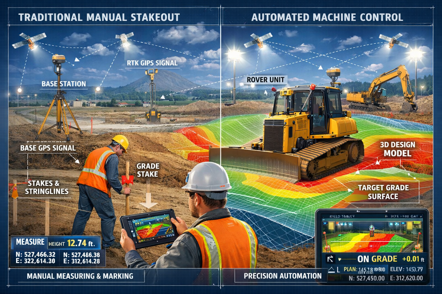
Machine control systems represent the integration of positioning technology, digital design models, and automated equipment controls to guide construction machinery with unprecedented precision. These systems use Global Navigation Satellite Systems (GNSS), laser sensors, or total stations to determine a machine's exact position and orientation in three-dimensional space.[4]
The technology then compares the machine's current position against a digital design model—essentially a computerized blueprint of the finished project. When the excavator bucket or dozer blade deviates from the intended grade, the system automatically adjusts the hydraulics to maintain the correct elevation and slope.[4]
This automation eliminates the traditional workflow where surveyors would:
- Calculate stake positions from design plans
- Physically travel to the site to set stakes
- Mark grade elevations on each stake
- Return periodically to verify progress
- Reset stakes as they're destroyed by equipment
Instead, the digital model lives inside the machine's control system, providing continuous, real-time guidance without physical markers cluttering the construction site.
The Evolution from Manual to Automated Workflows
The transition to automated systems represents what Trimble experts characterize as "evolution not revolution" for construction technology in 2026.[2] Rather than overnight transformation, the industry has experienced steady advancement in foundational technologies that enable smarter machines and workflows.
Early machine control systems required extensive technical knowledge and specialized training. Operators needed to understand coordinate systems, projection methods, and complex calibration procedures. This complexity limited adoption to large contractors with dedicated technology specialists.
By 2026, however, reality capture technology has become accessible to surveying firms of all sizes through user-friendly tools and broader platform support.[2] Modern systems feature intuitive touchscreen interfaces, simplified setup procedures, and automated calibration routines that reduce the learning curve dramatically.
This democratization enables smaller property development firms and regional contractors to implement machine control without maintaining large technical support teams.
Key Components of Machine Control Systems
A complete machine control system consists of several integrated components:
| Component | Function | Technology Type |
|---|---|---|
| Positioning Sensors | Determine machine location and orientation | GNSS receivers, laser receivers, total station prisms |
| Control Box | Processes position data and manages hydraulics | Industrial computer with specialized software |
| Display Interface | Shows operator current position vs. design | Ruggedized touchscreen in cab |
| Hydraulic Controllers | Automatically adjust blade/bucket position | Electro-hydraulic valves |
| Design Model | Digital representation of finished grade | 3D surface file (DTM/TIN format) |
| Base Station | Provides correction data for GNSS positioning | RTK base station or CORS network connection |
The positioning accuracy varies by technology type. GNSS-based systems typically achieve 2-3 centimeter precision in optimal conditions, while laser-based systems can reach millimeter-level accuracy for applications like concrete paving.[4]
How Machine Control Systems in Property Surveying Automate Earthworks for 2026 Efficiency
Eliminating Traditional Stakeout Procedures
The most immediate benefit of machine control is the elimination of physical stakeout work. Traditional construction required surveyors to calculate and physically mark hundreds or thousands of grade points across a site. This labor-intensive process consumed significant time and created ongoing maintenance requirements as stakes were inevitably destroyed by equipment.
With machine control, the surveyor's role shifts from physical stake placement to digital model creation and quality assurance. The surveyor processes site topography data, integrates design plans, and creates a comprehensive digital terrain model (DTM) that represents the finished grade.[5]
This digital model is then transferred to the machine control system—either via USB drive, wireless connection, or increasingly through cloud-based collaboration platforms that enable instant updates across all equipment on site.[2]
The time savings are substantial. Projects that previously required days of stakeout work can now begin earthmoving operations within hours of survey completion. For large sites with complex grading requirements, this acceleration can reduce overall project timelines by weeks.
Real-Time Precision and Error Reduction
Machine control systems provide continuous feedback to equipment operators, showing exactly where the blade or bucket is positioned relative to the design grade. This real-time guidance eliminates the guesswork inherent in traditional methods where operators worked from stakes that might be 15-20 meters apart.
The precision benefits extend beyond simple elevation control. Modern systems manage:
- Cross-slope accuracy for proper drainage
- Transition zones between different grade sections
- Curved alignments for roads and parking areas
- Complex surface geometries that would be extremely difficult to stake manually
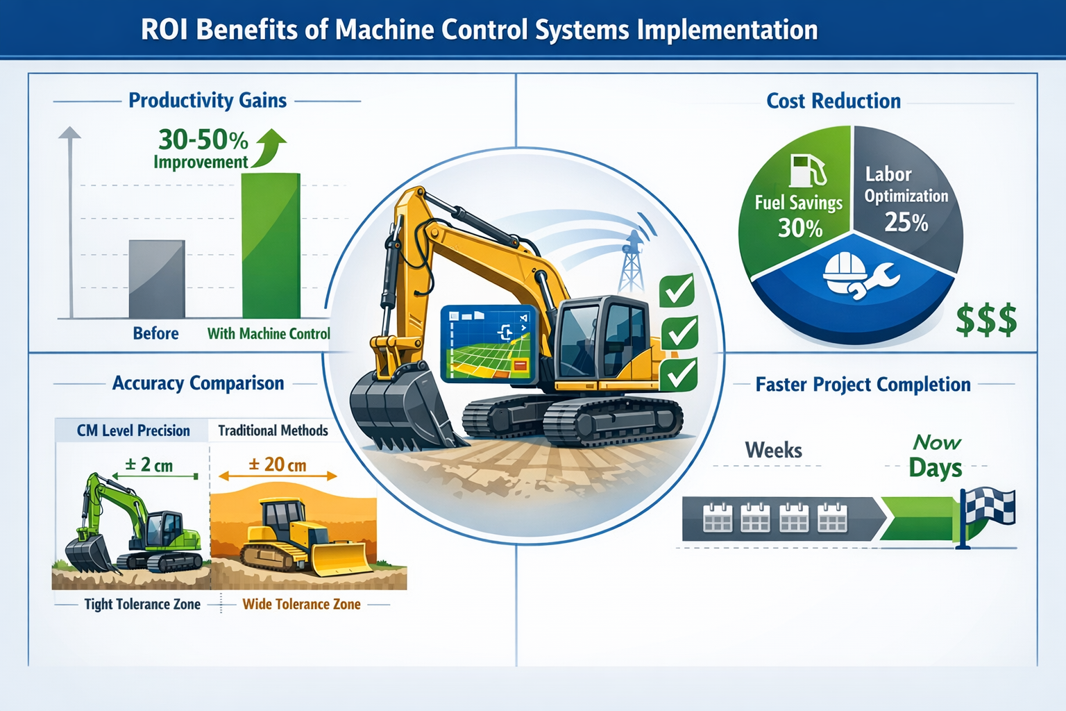
This precision reduces over-excavation and under-excavation errors that waste material and require costly rework. When an operator cuts too deep with traditional methods, additional fill material must be imported. When they don't cut deep enough, equipment must make multiple passes to reach grade. Both scenarios increase fuel consumption, labor costs, and project duration.
Studies indicate that machine control can reduce over-excavation by 30-50% compared to traditional methods, directly impacting material costs and environmental footprint.[8]
Productivity Gains Across Construction Workflows
Beyond accuracy improvements, machine control delivers significant productivity enhancements throughout the construction process. Operators can work effectively in conditions that would halt traditional operations:
🌙 Low-light conditions: With digital guidance, operators can continue productive work during early morning, evening, or overcast conditions when grade stakes would be difficult to see.
🌫️ Reduced site visits: Surveyors spend less time traveling to and from sites for stake placement and verification, allowing them to support more projects simultaneously.
⚡ Faster learning curve: New operators achieve productive performance more quickly when the system provides continuous guidance rather than requiring them to interpret stakes and make judgment calls.
🔄 Parallel workflows: Design changes can be implemented immediately without waiting for surveyors to restake the site, enabling construction to proceed while engineers refine plans.
The entire excavation process is becoming increasingly automated in 2026, improving productivity across full construction workflows.[4] Modern systems don't just guide the blade—they're enabling machines to function as sensors for real-time project monitoring, automatically documenting as-built conditions during production work.
Integration with Building Information Modeling (BIM)
The convergence of machine control with Building Information Modeling (BIM) represents a significant advancement in how construction projects are planned and executed. BIM creates comprehensive 3D models that include not just the building structure but also site grading, utilities, and landscaping.
When machine control systems connect directly to BIM platforms, the earthwork design becomes a seamless extension of the overall project model. Changes made by engineers or architects automatically propagate to the grading plan, ensuring consistency across all project phases.
This integration supports more sophisticated property development projects where building placement, drainage design, and utility routing must be coordinated precisely. The digital model ensures that the excavator preparing foundation trenches works from the same coordinate system as the concrete crew forming footings and the plumber installing underground utilities.
Implementing Machine Control Systems in Property Surveying: Automating Earthworks and Stakeouts
Technology Selection and System Design
Selecting appropriate machine control technology requires careful evaluation of project requirements, site conditions, and budget constraints. The primary technology options include:
GNSS-Based Systems utilize satellite positioning to determine machine location. These systems offer:
- Flexibility to work anywhere on site without line-of-sight requirements
- Rapid setup with minimal infrastructure
- Suitability for large, open sites with good satellite visibility
- Typical accuracy of 2-3 centimeters in horizontal and vertical dimensions
Laser-Based Systems use a rotating laser transmitter to create a reference plane. These systems provide:
- Extremely high precision (millimeter-level accuracy)
- Consistent performance regardless of satellite conditions
- Ideal for confined sites or areas with obstructions
- Limited working radius (typically 300-400 meters from transmitter)
Total Station Systems employ robotic surveying instruments that track prisms mounted on equipment. These offer:
- High accuracy across moderate working areas
- Ability to work in environments where GNSS is unreliable
- Single-machine tracking per total station
- More complex setup and calibration requirements
Many contractors in 2026 are implementing hybrid approaches that combine multiple technologies to optimize performance across diverse project conditions.[2]
Surveyor's Role in Digital Model Creation
While machine control eliminates physical stakeout, it creates new responsibilities for surveyors in digital model preparation and quality assurance. The accuracy of automated earthwork depends entirely on the quality of the digital terrain model provided to the equipment.
The surveyor's workflow for machine control projects typically includes:
- Site topography capture: Using total stations, GNSS rovers, or increasingly drone-based photogrammetry to document existing conditions
- Design surface creation: Processing civil engineering plans to create 3D surface models representing finished grade
- Model validation: Checking for errors, gaps, or inconsistencies that could cause equipment malfunction
- Coordinate system management: Ensuring all data uses consistent projection and datum
- Quality control verification: Conducting spot checks during construction to validate system performance
This shift from field-intensive stakeout work to office-based modeling represents a fundamental change in surveying practice. Successful firms are investing in training and software tools that enable efficient digital model creation.
The cost of measured building surveys and site topography work may initially appear higher when using advanced capture technologies, but the elimination of repeated site visits for stakeout and verification typically results in lower overall project costs.
Training and Workforce Development
Implementing machine control requires investment in training for both surveyors and equipment operators. While modern systems have become more user-friendly, effective utilization still demands understanding of fundamental concepts.
Surveyor training should address:
- Digital terrain modeling software proficiency
- Understanding of GNSS positioning principles and error sources
- Quality control procedures for model validation
- Troubleshooting common system issues
- Coordinate system and projection management
Operator training focuses on:
- System calibration and setup procedures
- Interpreting the in-cab display effectively
- Understanding when to trust automation versus manual control
- Basic troubleshooting of positioning and communication issues
- Proper maintenance of sensors and components
Many equipment manufacturers and software vendors offer certification programs that provide structured training and ongoing technical support. These programs have become increasingly important as the technology evolves and new capabilities emerge.
Overcoming Implementation Challenges
Despite the clear benefits, firms transitioning to machine control often encounter challenges that can impede successful adoption:
Initial Investment Costs: Machine control systems represent significant capital expenditure, typically ranging from £15,000 to £50,000 per machine depending on technology and features. For smaller contractors, this investment can be difficult to justify without guaranteed project volume.
Workflow Disruption: Transitioning from familiar manual methods to digital workflows requires patience as teams develop new processes and troubleshoot unexpected issues. Projects may initially take longer as everyone learns the new systems.
Technology Reliability: While machine control has matured significantly, systems still occasionally experience failures due to satellite signal loss, radio interference, or equipment malfunctions. Having backup procedures ensures these issues don't halt production entirely.
Model Preparation Time: Creating accurate digital terrain models requires time and expertise. Firms sometimes underestimate the effort required, leading to rushed model preparation that compromises accuracy.
Successful implementation typically follows a phased approach where firms start with simpler projects, develop expertise gradually, and expand capabilities as confidence grows. This measured progression reduces risk and allows time for workforce adaptation.
The Business Case: ROI and Competitive Advantages
Quantifying Cost Savings and Efficiency Gains
The financial benefits of machine control extend across multiple dimensions of construction operations. While the initial investment is substantial, the return typically materializes within the first year of operation for contractors with steady project volume.
Material Cost Reduction: By minimizing over-excavation, machine control directly reduces the volume of material that must be imported or exported from sites. On a typical grading project, reducing over-excavation by 30% can save thousands of pounds in material and hauling costs.
Labor Efficiency: Eliminating stakeout work frees surveyors to support more projects simultaneously. A surveyor who previously spent three days per week setting and checking stakes can now manage digital models for multiple active sites from the office.
Fuel Savings: Precise guidance reduces the number of passes equipment must make to achieve grade, directly reducing fuel consumption. Contractors report fuel savings of 20-30% on projects using machine control.[8]
Rework Elimination: When earthwork is completed accurately the first time, costly rework to correct grade errors is eliminated. This benefit extends to subsequent construction phases—foundations built on properly prepared subgrade don't experience settlement issues that require remediation.
Schedule Acceleration: Faster earthwork completion allows subsequent trades to begin sooner, compressing overall project timelines. For time-sensitive projects, this acceleration can be worth more than the direct cost savings.
Competitive Differentiation in the 2026 Market
As machine control becomes standard practice, firms without this capability increasingly find themselves at a competitive disadvantage when bidding projects. Clients recognize that automated systems deliver superior quality and reliability, making them willing to pay a premium for contractors with proven machine control expertise.
The technology also enables firms to pursue project types that would be impractical with manual methods:
- Complex grading projects with intricate drainage requirements
- Large-scale earthworks where manual stakeout would be prohibitively expensive
- Fast-track projects with compressed schedules
- Projects in challenging environments where frequent restaking would be required
Contractors who master machine control can differentiate their services and command higher margins, particularly for sophisticated clients who understand the value proposition.
Expanding Service Offerings Beyond Initial Construction
One of the most significant opportunities emerging in 2026 relates to the lifecycle value of spatial data captured during construction. Infrastructure owners increasingly recognize that 75% of an asset's total cost of ownership accrues during operations and maintenance, not initial construction.[2]
This creates opportunities for surveyors to expand services beyond traditional construction support into asset management and facility operations. The digital models created for machine control become the foundation for:
- As-built documentation that accurately reflects constructed conditions
- Facility management systems that track asset locations and attributes
- Maintenance planning based on accurate spatial inventory
- Renovation and expansion projects that reference existing conditions
Spatial data applications in asset management enable a shift from reactive maintenance to predictive maintenance, reducing costs by as much as 40% through better performance assessment and maintenance need identification.[2]
Forward-thinking surveying firms are positioning themselves as long-term partners who support clients throughout the asset lifecycle, not just during initial construction. This strategic shift creates recurring revenue opportunities and deeper client relationships.
Future Trends: Where Machine Control Systems Are Heading
Autonomous Equipment and AI Integration
The progression toward fully autonomous construction equipment continues steadily in 2026, though industry experts emphasize this represents "evolution not revolution" rather than dramatic overnight changes.[2] Current machine control systems still require human operators to manage the equipment, but the level of automation is increasing incrementally.
Emerging capabilities include:
🤖 Autonomous path planning: Systems that calculate optimal equipment paths to minimize fuel consumption and cycle times
🧠 AI-powered optimization: Machine learning algorithms that adapt to soil conditions and adjust cutting strategies automatically
📊 Predictive maintenance: Systems that monitor equipment performance and predict component failures before they occur
🔍 Automated quality verification: Using onboard sensors to document as-built conditions without separate verification surveys
These advancements don't eliminate the need for skilled operators and surveyors—instead, they elevate their roles to focus on oversight, quality assurance, and problem-solving rather than routine execution tasks.
Cloud-Based Collaboration and Real-Time Data Sharing
The convergence of cloud-based collaboration platforms and interoperable hardware and software is fundamentally reshaping how spatial data is captured, processed, and shared across construction teams.[2]
In 2026, leading contractors are implementing workflows where:
- Design models are stored in cloud repositories accessible to all project stakeholders
- Equipment automatically uploads as-built data to the cloud during production
- Project managers monitor progress in real-time from any device
- Design changes propagate instantly to all equipment on site
- Quality control personnel receive automated alerts when deviations exceed tolerance
This connectivity transforms construction from a sequential process (design → survey → stake → build → verify) to a parallel, collaborative workflow where multiple activities proceed simultaneously with continuous feedback.
The technology also enables better coordination with related disciplines. For example, understanding what is in a measured building survey becomes more relevant as existing structure data integrates seamlessly with site grading models for renovation projects.
3D GIS and Advanced Asset Management
Innovations in 3D GIS and advanced modeling technology are creating richer, more precise models of public assets, while AI and real-time spatial insights are redefining GIS-centric asset lifecycle management.[2]
Traditional GIS systems represented infrastructure as points, lines, and polygons on a two-dimensional map. Modern 3D GIS platforms incorporate:
- Detailed geometric models showing actual asset shapes and dimensions
- Temporal data tracking how assets change over time
- Attribute information linking spatial features to maintenance records, specifications, and performance data
- Sensor integration providing real-time monitoring of asset conditions
For surveyors supporting infrastructure owners, this evolution creates opportunities to provide ongoing spatial data services throughout the asset lifecycle. The initial survey work for construction becomes the foundation for a living digital twin that evolves as the asset is maintained, modified, and eventually replaced.
Geographic Expansion and Market Growth
While machine control adoption is mature in developed markets like the United States (growing at 4.4% annually), emerging economies are experiencing rapid acceleration. China's market is expanding at 8.7% growth rate, driven by government infrastructure investment and urbanization initiatives.[3]
This geographic expansion creates opportunities for:
- Technology providers to enter new markets with proven solutions
- Training organizations to support workforce development in emerging regions
- Surveyors with machine control expertise to support international projects
- Equipment manufacturers to adapt systems for regional requirements and preferences
The democratization of technology through user-friendly tools and broader platform support makes it easier for firms in developing markets to implement machine control without extensive technical infrastructure.[2]
Best Practices for Surveyors Supporting Machine Control Projects
Pre-Construction Planning and Coordination
Successful machine control projects begin with thorough pre-construction planning that establishes clear communication protocols and quality standards. Key planning activities include:
Coordinate System Agreement: All project stakeholders must work in the same coordinate system. Establishing this early prevents costly errors when data from different sources doesn't align properly.
Accuracy Requirements Definition: Different project elements require different precision levels. Foundation excavation may require centimeter-level accuracy, while rough grading might tolerate larger tolerances. Documenting these requirements ensures appropriate technology selection.
Data Exchange Protocols: Establishing how design models will be formatted, transferred, and updated prevents confusion and ensures compatibility with equipment systems.
Quality Control Procedures: Defining how accuracy will be verified during construction—including spot check frequency and acceptable tolerance ranges—creates accountability and ensures project standards are met.
These planning activities should involve the surveyor, design engineer, contractor, and equipment operators to ensure everyone understands their roles and responsibilities.
Quality Assurance and Verification Procedures
While machine control systems provide real-time guidance, independent quality verification remains essential to ensure accuracy and catch system errors before they impact subsequent construction phases.
Recommended verification procedures include:
✓ Initial calibration checks: Verifying system accuracy before production begins by checking known control points
✓ Periodic spot checks: Using independent survey methods (total station or GNSS rover) to verify finished grades at representative locations
✓ As-built documentation: Conducting comprehensive surveys after earthwork completion to document actual conditions
✓ Statistical analysis: Tracking verification results over time to identify systematic errors or calibration drift
The frequency of verification depends on project requirements and risk tolerance. Critical applications like foundation preparation may warrant continuous monitoring, while less sensitive work might require only periodic checks.
Documentation of quality verification provides valuable protection for all parties. When disputes arise about whether work meets specifications, comprehensive verification records provide objective evidence of actual conditions.
Troubleshooting Common Issues
Even well-planned machine control projects occasionally encounter technical issues that impact productivity. Surveyors supporting these projects should understand common problems and solutions:
Poor GNSS Accuracy: Caused by satellite geometry, atmospheric conditions, or radio interference. Solutions include switching to laser or total station positioning, using correction services with better coverage, or waiting for improved satellite constellation.
Model Errors: Gaps, overlaps, or inconsistencies in digital terrain models can cause equipment to behave erratically. Thorough model validation before deployment prevents these issues.
Calibration Drift: Machine control systems require periodic recalibration as equipment components shift or settle. Establishing regular calibration schedules maintains accuracy.
Communication Failures: Radio links between base stations and equipment can be disrupted by terrain, structures, or interference. Ensuring adequate radio coverage and having backup communication methods prevents downtime.
Experienced surveyors develop troubleshooting protocols that quickly identify and resolve these issues, minimizing impact on production schedules.
Continuing Education and Professional Development
The rapid evolution of machine control technology requires ongoing professional development to maintain expertise. Effective strategies include:
📚 Manufacturer training programs: Equipment and software vendors offer regular training on new features and capabilities
🎓 Professional association courses: Organizations like RICS provide surveying-specific education on emerging technologies
💻 Online learning platforms: Self-paced courses allow professionals to develop skills around project schedules
🤝 Peer networking: Industry conferences and local user groups facilitate knowledge sharing among practitioners
Firms that prioritize continuing education maintain competitive advantages as technology evolves. The investment in training typically returns multiples through improved efficiency and expanded service capabilities.
Understanding broader surveying contexts, such as why property owners hire surveyors, helps position machine control capabilities within the full range of professional services clients need.
Conclusion: Embracing the Automated Future of Construction Surveying

Machine Control Systems in Property Surveying: Automating Earthworks and Stakeouts for 2026 Construction Efficiency represents far more than incremental technology improvement—it signals a fundamental transformation in how construction projects are planned, executed, and managed. The shift from manual stakeout to digital automation delivers measurable benefits across productivity, accuracy, cost, and safety dimensions.
As the global land survey equipment market reaches USD 8.7 billion in 2026[3], the message is clear: machine control has evolved from optional technology to essential infrastructure for competitive construction operations.[2] Firms that embrace this transformation position themselves for success, while those clinging to traditional methods face increasing disadvantage.
The democratization of technology through user-friendly tools and broader platform support[2] means that surveying firms of all sizes can participate in this evolution. The barriers to entry continue declining, making 2026 an ideal time for firms to evaluate their technology strategies and plan implementation roadmaps.
Actionable Next Steps
For surveying firms and construction professionals ready to advance their machine control capabilities:
-
Assess current capabilities: Conduct honest evaluation of existing technology, skills, and workflows to identify gaps and opportunities
-
Develop implementation roadmap: Create phased plan that starts with manageable projects and expands as expertise develops
-
Invest in training: Prioritize workforce development to ensure teams can effectively utilize new technologies
-
Build strategic partnerships: Establish relationships with equipment vendors, software providers, and experienced practitioners who can provide guidance
-
Start with pilot projects: Select appropriate initial projects that allow learning without excessive risk
-
Document results: Track performance metrics to quantify benefits and refine processes
-
Expand service offerings: Leverage machine control capabilities to pursue new project types and client relationships
The future of construction surveying is undeniably digital, collaborative, and increasingly automated. Firms that embrace these changes while maintaining focus on fundamental surveying principles—accuracy, precision, and professional integrity—will thrive in the evolving landscape.
The technology continues advancing, with autonomous equipment, AI integration, and cloud-based collaboration reshaping workflows in ways that seemed impossible just years ago. Yet the core value proposition remains constant: providing clients with accurate spatial information that enables confident decision-making and successful project outcomes.
Whether supporting large infrastructure developments or smaller property development projects, machine control systems empower surveyors to deliver superior results with greater efficiency. The question is no longer whether to adopt these technologies, but how quickly firms can implement them effectively.
The construction industry's digital transformation accelerates daily. Surveyors who position themselves at the forefront of this evolution—mastering machine control, embracing cloud collaboration, and expanding into lifecycle asset management—will find abundant opportunities in 2026 and beyond.
References
[1] Ai Driven Precision In Property Surveying How Artificial Intelligence Is Revolutionizing Workflows In 2026 – https://nottinghillsurveyors.com/blog/ai-driven-precision-in-property-surveying-how-artificial-intelligence-is-revolutionizing-workflows-in-2026
[2] Doubling Down On Digital – https://amerisurv.com/2026/02/01/doubling-down-on-digital/
[3] Land Survey Equipment Market – https://www.futuremarketinsights.com/reports/land-survey-equipment-market
[4] Machine Control The Basics – https://www.topconpositioning.com/articles/machine-control—the-basics
[5] Machine Control Model – https://www.quantumlanddesign.com/machine-control-model
[6] Doubling Down On Digital Top 6 Surveying Trends Shaping 2026 From Trimble Experts – https://nottinghillsurveyors.com/blog/doubling-down-on-digital-top-6-surveying-trends-shaping-2026-from-trimble-experts
[7] Carlson Construction – https://carlsonps.com/products/carlson-construction
[8] From Manual To Automated Transitioning To Machine Control Technology – https://www.southeasternequip.com/from-manual-to-automated-transitioning-to-machine-control-technology/