A property with valid development conditions attached to it sells for 27 to 29 percent more than a comparable plot without such permits — a finding from research published in the journal Land Use Policy that underscores a truth many buyers and investors overlook: the paperwork and professional assessments tied to land can be worth more than the land itself [5]. Understanding how land surveys directly impact property values and development potential is not just useful knowledge for developers — it is essential for any owner, investor, or buyer who wants to make informed decisions and protect their financial interests.
Key Takeaways
- Accurate boundary surveys eliminate legal uncertainty, which directly supports stronger and more defensible property valuations.
- Zoning and planning data revealed through surveys can unlock hidden development potential that title searches alone will not show.
- Physical characteristics identified during a survey — including terrain, drainage, and soil quality — determine construction feasibility and cost.
- Land assemblage, enabled by precise boundary delineation, can substantially increase the combined value of adjacent parcels.
- Survey-backed valuations reduce the risk of disputes, giving buyers, lenders, and investors greater confidence in a transaction.
Why Boundary Clarity Is the Foundation of Property Value
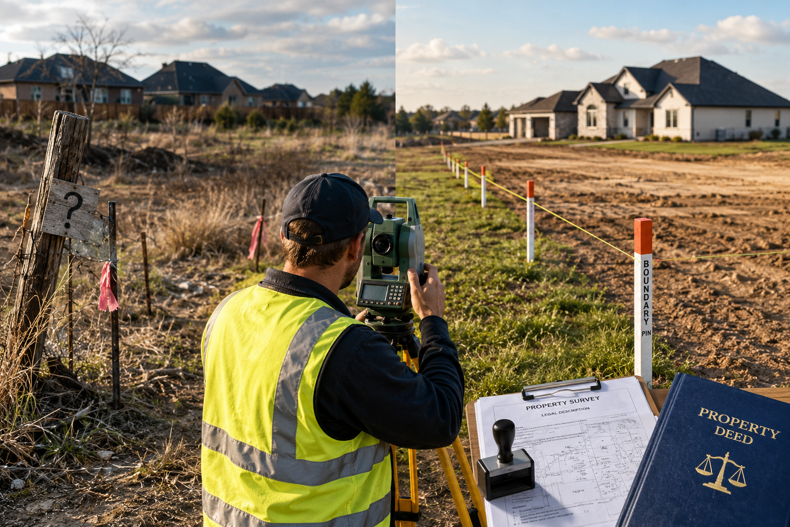
Every property transaction rests on a single assumption: that the boundaries of the land being sold are accurately known. When that assumption is wrong, the consequences range from costly disputes to collapsed sales. How land surveys directly impact property values and development potential begins at this most fundamental level — establishing exactly where one owner's land ends and another's begins.
Boundary disputes are expensive. The average cost of a boundary dispute can run into tens of thousands of pounds when legal fees, expert witnesses, and lost time are factored in. A professional land survey conducted before a sale or development project eliminates the ambiguity that fuels these disputes in the first place.
Survey-backed valuations provide objective verification of property boundaries and characteristics, reducing the risk of disputes and legal issues, and offering assurance to buyers and lenders alike [2]. When a lender sees a professionally surveyed plot with clearly defined boundaries, they are more willing to lend at competitive rates. When a buyer sees the same, they are less likely to negotiate aggressively on price.
How Inaccurate Land Area Distorts Valuations
One of the more subtle ways that poor surveying undermines property values is through inaccurate land area calculations. Irregular plot shapes, encroachments, and unrecorded easements can all cause the stated area of a property to differ significantly from its actual net usable area.
Professional surveys ensure that the net usable land area is correctly identified, accounting for irregular plot shapes and setbacks. Inaccurate land area calculations distort price-per-square-foot benchmarks, leading to misleading valuations [2]. For a buyer paying a premium per square metre, even a modest discrepancy in recorded area can translate into a substantial overpayment.
"Accurate land measurement is not a bureaucratic formality — it is the bedrock on which fair market value is calculated."
Before listing a property, it is worth understanding what factors are looked at during a property valuation to appreciate how boundary accuracy feeds directly into the figures a valuer will produce.
Zoning Insights, Development Rights, and Market Perception
The second major dimension of how land surveys directly impact property values and development potential relates to planning and zoning. A survey does far more than measure distances — it can reveal the regulatory framework that governs what can be built, how tall, how dense, and for what purpose.
Uncovering Hidden Development Potential
Comprehensive land surveys can uncover zoning classifications and permitted development rights, potentially revealing opportunities for mixed-use development that may not be apparent through title searches alone [1]. This is particularly relevant in urban fringe areas where a plot may straddle two different zoning designations, or where planning history has created permitted development rights that are not immediately visible in standard searches.
For investors and developers, this kind of intelligence is enormously valuable. A site that appears to be a modest residential plot on paper may, following a thorough survey and planning analysis, prove suitable for a small commercial unit, additional dwellings, or a mixed-use scheme. The difference in value between those two scenarios can be dramatic.
Research consistently shows that development potential is capitalised into land prices. Studies on agricultural land have demonstrated that option values associated with uncertain future land development are factored into current farmland prices, meaning the market is already pricing in the possibility of future use changes [4]. A survey that confirms — or reveals — those possibilities gives buyers and sellers a factual basis for negotiating accordingly.
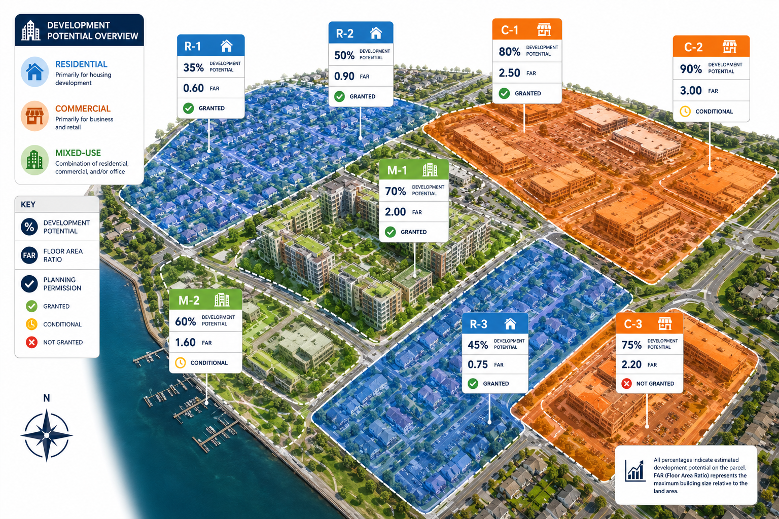
Regulatory Compliance and Floor Area Ratio
Surveys confirm a property's adherence to zoning rules, floor area ratio (FAR) limits, and planning regulations, which are crucial for assessing development potential and ensuring legal compliance [2]. For a developer planning a new build or extension, knowing the maximum permissible floor area before committing to a site can be the difference between a viable scheme and a planning refusal.
Understanding what is covered in a measured building survey is an important step for anyone planning a significant development, as these surveys provide the precise spatial data that planning applications and architectural drawings depend upon.
Market Perception and Buyer Confidence
Beyond the technical data, surveys shape how a property is perceived in the market. A site that comes with a recent, professional survey signals transparency and reduces the perceived risk for buyers. This reduced risk perception translates directly into stronger offers and faster sales.
Consider the contrast: two adjacent plots of similar size go to market. One has a full boundary survey, confirmed zoning data, and a clean title. The other has none of these. Even if the underlying land is identical, the surveyed plot will attract more interest, more competitive bids, and ultimately a higher sale price. The survey has not changed the land — it has changed what buyers know about the land, and knowledge reduces risk premiums.
Physical Characteristics, Land Assemblage, and Maximising ROI
The third major way that how land surveys directly impact property values and development potential manifests is through the physical assessment of land characteristics and the strategic opportunities that precise survey data enables.
Terrain, Soil, and Drainage: The Hidden Cost Drivers
Surveys provide precise measurements of parcel shape, terrain gradient, soil quality, and drainage patterns, all of which directly influence construction feasibility and costs [1]. A plot that looks flat and buildable from the road may conceal a significant gradient change, a high water table, or poor load-bearing soil — any of which can add substantial costs to a development project.
The table below illustrates how common physical characteristics identified in surveys affect development costs and, by extension, land value:
| Physical Characteristic | Development Impact | Effect on Land Value |
|---|---|---|
| Steep gradient (over 10%) | Increased groundwork and retaining costs | Reduces value unless offset by views |
| Poor soil bearing capacity | Requires deep or specialist foundations | Significant cost addition, reduces value |
| High water table | Drainage engineering required | Increases build cost, reduces net value |
| Irregular plot shape | Limits building footprint options | May reduce usable area and value |
| Contamination indicators | Remediation costs before build | Can severely reduce or eliminate value |
| Access constraints | Road adoption or easement costs | Reduces development viability |
For anyone considering a renovation or new build, understanding these physical factors early is essential. Reviewing the order in which to renovate a property becomes far more straightforward once a full survey has established the physical baseline of the site.
Land Assemblage: Creating Value Through Combination
One of the most powerful — and least discussed — ways that accurate surveys create value is through land assemblage. This is the process of combining two or more adjacent parcels into a single, larger developable tract.
Accurate boundary delineation through surveys simplifies the process of combining adjacent parcels, thereby creating larger, more developable tracts. This process, known as land assemblage, can substantially enhance property value [1]. A collection of small plots that individually fall below the threshold for viable development may, when assembled and surveyed as a single entity, support a scheme that is financially attractive to developers.
This is why accurate boundary surveys are not just a due diligence exercise — they are a strategic tool. Investors who understand the boundaries of neighbouring plots are better positioned to identify assemblage opportunities before they become obvious to the wider market.
Proximity to Open Space and Infrastructure
Survey data also informs value in a more contextual sense. Research in Berks County, Pennsylvania found that within 400 metres of a house, open space had the most positive impact on house prices [3]. Surveys that accurately map a property's relationship to parks, green corridors, and public open space provide buyers and valuers with data that supports premium pricing.
Equally, proximity to infrastructure — roads, utilities, transport links — is a double-edged factor. Research has shown that freeway construction can have a negative effect on the value of detached single-family homes but a positive effect on multifamily residential developments and most commercial properties [6]. A thorough survey that maps a site's relationship to existing and planned infrastructure allows owners and investors to position their asset correctly within the market.
Leveraging Survey Data to Negotiate and Add Value
For property owners preparing to sell, a recent survey is one of the most cost-effective investments available. Understanding how to negotiate a house price after a survey works in both directions — sellers armed with survey data are in a stronger position to defend their asking price against post-survey price reductions.
For buyers, commissioning a full building survey before exchange gives them the information needed to negotiate accurately, plan for future development, and avoid costly surprises. The survey cost is almost always recovered many times over through better-informed decision-making.
It is also worth noting that measured surveys — which produce accurate floor plans and site dimensions — are increasingly required by planning authorities and architects before any significant development application is accepted. Having this data ready reduces delays and demonstrates professional intent to planners.
Practical Steps for Owners and Investors
Understanding the theory is valuable. Acting on it is where the financial benefit is realised. Here is a structured approach to leveraging survey data for maximum return:
Before purchasing land or property:
- Commission a boundary survey to confirm the legal extent of the plot
- Request a measured survey if planning any extension, conversion, or new build
- Review zoning classifications and permitted development rights revealed by the survey
- Assess physical characteristics — gradient, drainage, soil — for their impact on build cost
Before selling:
- Obtain a current boundary survey to pre-empt buyer challenges
- Ensure the stated land area matches the surveyed area
- Highlight any development potential confirmed by the survey in marketing materials
- Consider an independent property valuation that incorporates survey findings
For development projects:
- Use survey data to identify land assemblage opportunities
- Confirm regulatory compliance before submitting planning applications
- Factor physical characteristic findings into project cost modelling
- Use survey-confirmed data to support funding applications and investor presentations
Conclusion
How land surveys directly impact property values and development potential is not a niche concern for specialists — it is a core factor in every property transaction, development decision, and investment strategy. Boundary clarity eliminates the legal uncertainty that depresses values and deters buyers. Zoning and planning data revealed through surveys unlocks development potential that would otherwise remain invisible. Physical characteristic assessments prevent costly surprises and support accurate project budgeting. And land assemblage opportunities, identified through precise boundary work, can transform the economics of a site entirely.
In 2026, with planning regulations continuing to evolve and competition for developable land intensifying, the owners and investors who commission thorough, professional surveys are the ones who make better decisions, negotiate from a position of knowledge, and ultimately achieve stronger returns. A survey is not a cost — it is an investment in certainty, and certainty is exactly what the property market rewards.
References
[1] How Land Surveys Boost Property Value Boundaries Development Potential And Market Edge – https://manchestersurveyors.com/how-land-surveys-boost-property-value-boundaries-development-potential-and-market-edge/?utm_source=openai
[2] Land Surveying Impact On Property Valuation Dubai – https://www.reliantsurveyors.com/blogs/land-surveying-impact-on-property-valuation-dubai?utm_source=openai
[3] The Impact Of Open Space And Potential Local Disamenities On Residential Property Values In Berks County Pennsylvania – https://library.weconservepa.org/library_items/10-The-Impact-of-Open-Space-and-Potential-Local-Disamenities-on-Residential-Property-Values-in-Berks-County-Pennsylvania?utm_source=openai
[4] Effects Potential Land Development Agricultural Land Prices – https://stavins.scholars.harvard.edu/publications/effects-potential-land-development-agricultural-land-prices?utm_source=openai
[5] Land Use Policy — Development Conditions and Land Values – https://www.sciencedirect.com/science/article/abs/pii/S0264837717303010?utm_source=openai
[6] Transportation Research Record — Highway Proximity and Property Values – https://journals.sagepub.com/doi/10.3141/1839-14?utm_source=openai