}
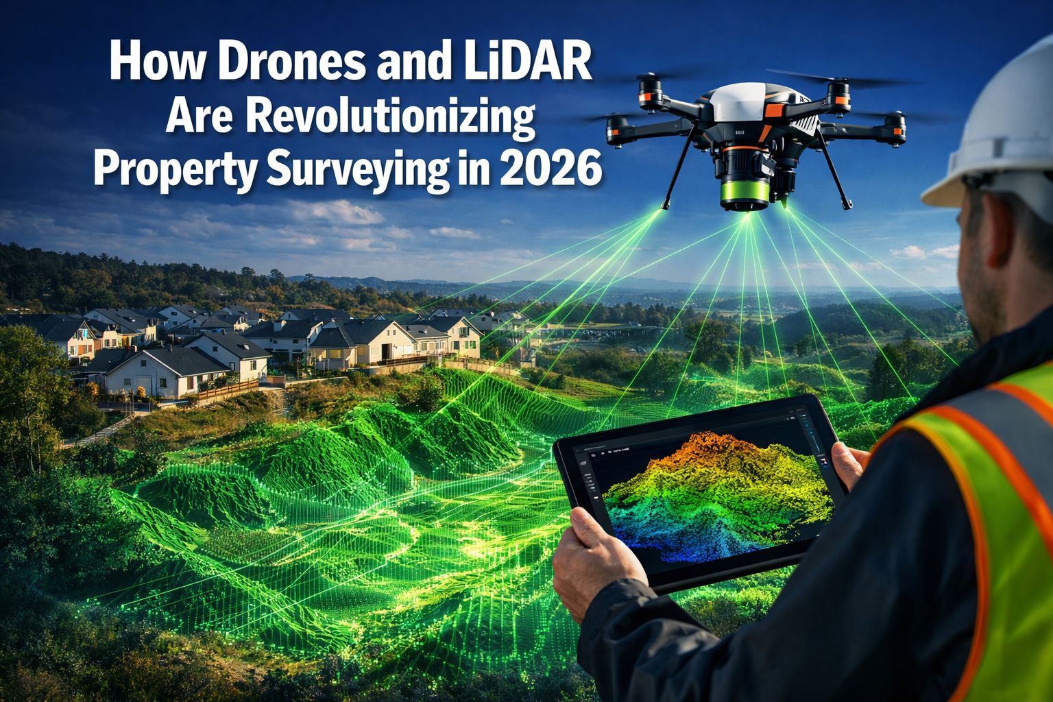
The property surveying industry is experiencing a transformation unlike anything seen in decades. Traditional methods that once required weeks of fieldwork, expensive equipment, and significant safety risks are being replaced by cutting-edge technology that delivers faster, more accurate, and cost-effective results. How drones and LiDAR are revolutionizing property surveying in 2026 represents more than just a technological upgrade—it marks a fundamental shift in how professionals approach boundary determination, topographic mapping, and site analysis.
Imagine completing a comprehensive topographic survey of a 50-acre property in just hours instead of days, with millimeter-level precision, and at a fraction of traditional costs. This is not a future possibility—it's the reality of property surveying in 2026. The combination of unmanned aerial vehicles (UAVs) equipped with Light Detection and Ranging (LiDAR) sensors has created unprecedented opportunities for surveyors, developers, and property professionals to gather detailed spatial data with remarkable efficiency.
Key Takeaways
- Cost savings of 60-75%: Drone LiDAR surveying reduces expenses dramatically compared to traditional methods, with surveys that once cost thousands now achievable for hundreds of pounds[1]
- Speed improvements of 80-90%: Large-area surveys that previously required days or weeks can now be completed in hours, accelerating project timelines significantly[1]
- Millimeter-level accuracy: LiDAR technology captures data with exceptional precision, creating highly detailed and reliable measurements for critical property decisions[1]
- Enhanced safety protocols: Drones eliminate the need for surveyors to work in hazardous environments, accessing remote or dangerous locations without human risk[1][2]
- Vegetation penetration capabilities: LiDAR sensors can see through dense foliage to map ground surfaces, revealing topography that would be impossible to survey using traditional methods[2]
Understanding the Technology Behind Modern Property Surveying
What Are Drones in Property Surveying?
Drones, also known as unmanned aerial vehicles (UAVs), are aircraft operated remotely without a pilot on board. In the context of property surveying, these sophisticated devices carry specialized sensors and cameras that capture detailed information about land, buildings, and terrain features. Professional surveying drones are equipped with GPS systems, stabilization technology, and advanced navigation capabilities that allow them to follow precise flight paths while collecting data.
The evolution of drone technology has made these tools increasingly accessible to surveying professionals. Modern surveying drones range from compact consumer-grade models suitable for small residential properties to industrial-grade platforms capable of carrying heavy LiDAR sensors over extensive commercial developments. FAA Part 107 remote pilots operate these systems under strict regulatory compliance, ensuring safety and professional standards[1].
What Is LiDAR Technology?
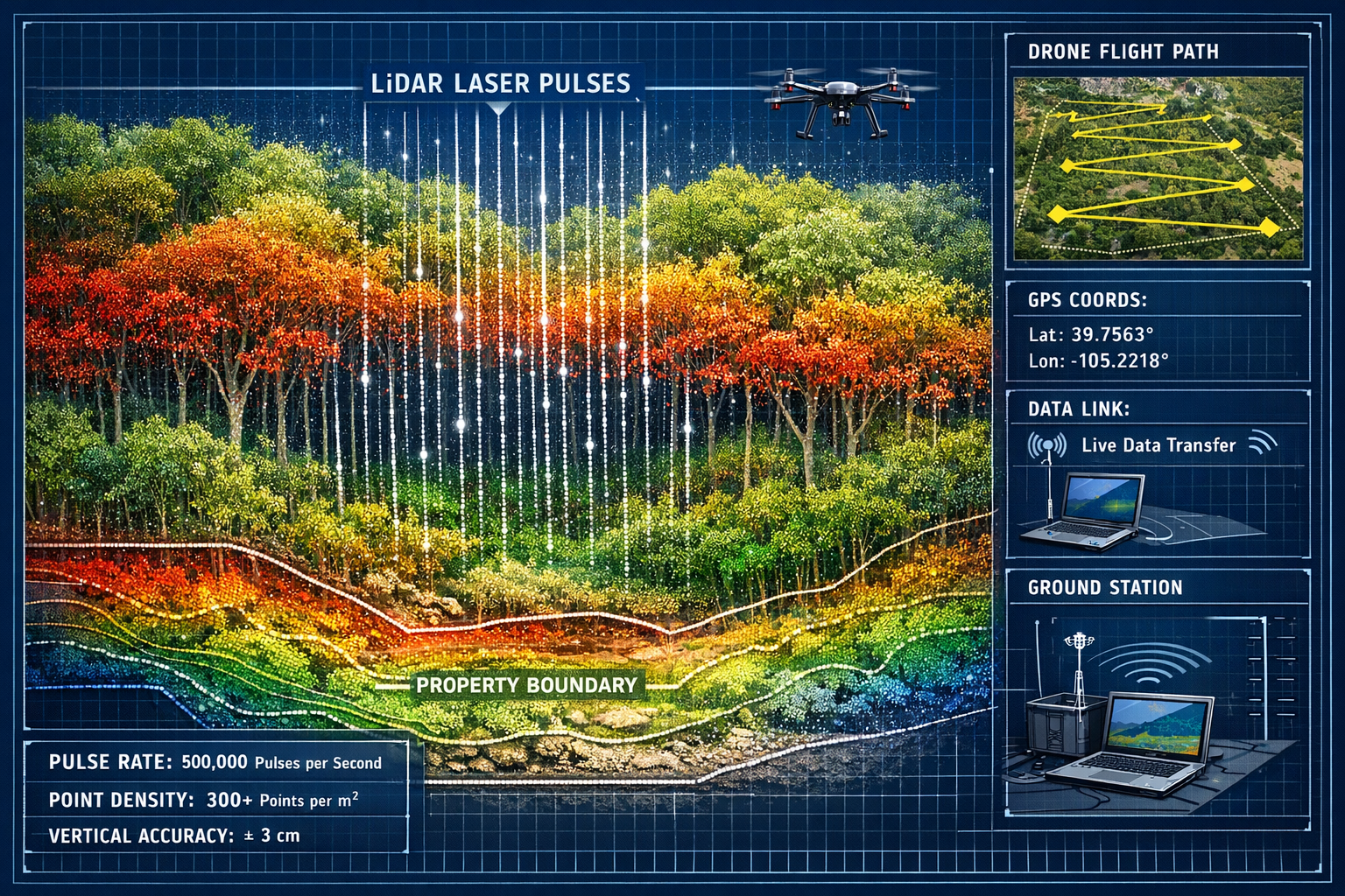
LiDAR (Light Detection and Ranging) is a remote sensing method that uses laser pulses to measure distances and create three-dimensional representations of surfaces. A LiDAR sensor emits rapid pulses of laser light—often hundreds of thousands per second—toward the ground. When these pulses hit objects, they bounce back to the sensor. By measuring the time it takes for each pulse to return, the system calculates precise distances.
The result is a "point cloud"—a collection of millions of individual data points that together form an incredibly detailed 3D model of the surveyed area. Each point contains information about its exact position in space, allowing surveyors to create accurate elevation models, identify features, and measure distances with millimeter-level precision[1].
The Synergy of Drones and LiDAR
When combined, drones and LiDAR create a powerful surveying solution that leverages the strengths of both technologies. The drone provides aerial mobility and access to difficult terrain, while the LiDAR sensor delivers precision measurement capabilities. This partnership enables surveyors to:
- Cover large areas quickly from optimal vantage points
- Access locations that would be dangerous or impossible to reach on foot
- Collect consistent, high-quality data across entire properties
- Generate multiple deliverables from a single flight mission
- Reduce fieldwork time while increasing data accuracy
For professionals seeking comprehensive property assessments, understanding what is a measured building survey provides context for how traditional methods compare to these modern approaches.
How Drones and LiDAR Are Revolutionizing Property Surveying Through Cost Reduction
The Economics of Traditional Surveying
Traditional property surveying methods have long been associated with substantial costs. Ground-based surveys require significant labor hours, with teams of surveyors spending days or weeks traversing properties on foot with total stations, GPS receivers, and measuring equipment. For large or complex sites, the expenses multiply quickly:
- Labor costs: Multiple surveyors working extended hours
- Equipment expenses: Specialized instruments requiring regular calibration and maintenance
- Transportation: Moving teams and equipment to remote or challenging locations
- Time delays: Weather interruptions and access difficulties extending project timelines
- Safety provisions: Insurance, protective equipment, and risk mitigation measures
Aerial surveying using manned aircraft offered some advantages but came with its own prohibitive costs, often running into thousands of pounds for even modest survey areas[1].
The Drone LiDAR Cost Advantage
The introduction of drone-based LiDAR surveying has fundamentally changed the economic equation. Traditional surveying methods that once cost thousands of pounds through manned aircraft can now be replicated for a fraction of the cost using drone aerial surveying[1]. This cost reduction stems from several factors:
Reduced Labor Requirements: A single qualified drone operator can often accomplish what previously required a team of surveyors. While ground verification and data processing still require professional expertise, the fieldwork component shrinks dramatically.
Lower Equipment Investment: Although professional LiDAR-equipped drones represent a significant initial investment, improvements in LiDAR technology have led to lower prices and smaller LiDAR sensors, lowering the barrier for entry in terms of cost[2]. This democratization of technology means more surveying firms can offer competitive services.
Faster Data Collection: Time is money in surveying projects. Drones can cover large areas in a fraction of the time it would take surveyors to collect data on foot, enabling projects to be completed more quickly and reducing overall costs[1]. A survey that might take a traditional crew five days could be completed in a single day with drone LiDAR technology.
Minimized Mobilization Costs: Deploying a drone team requires less logistical support than traditional surveying crews. Equipment is more portable, and the reduced time on-site means lower transportation and accommodation expenses for remote locations.
Real-World Cost Comparisons
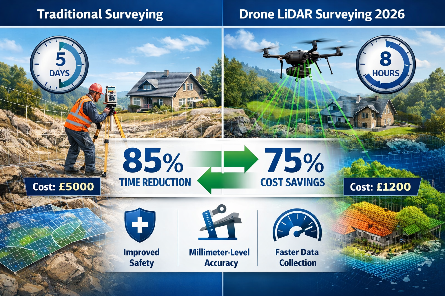
Consider a typical 25-acre property requiring topographic surveying for development planning:
| Method | Duration | Typical Cost | Accuracy |
|---|---|---|---|
| Traditional Ground Survey | 4-6 days | £4,000-£6,000 | ±10-20mm |
| Manned Aircraft LiDAR | 1-2 days | £3,000-£5,000 | ±50-100mm |
| Drone LiDAR Survey | 4-8 hours | £1,000-£2,000 | ±10-30mm |
These figures demonstrate cost savings of 60-75% compared to traditional methods, with comparable or superior accuracy and dramatically reduced timelines. For property developers and owners considering building pathology assessments, these savings can be reinvested in more comprehensive property analysis.
Long-Term Economic Benefits
Beyond immediate project costs, drone LiDAR surveying offers long-term economic advantages:
- Reduced rework: Higher accuracy means fewer mistakes requiring resurveying
- Better planning: Detailed data enables more informed decisions, reducing costly design changes
- Faster project timelines: Accelerated surveying allows earlier project commencement
- Competitive advantage: Firms offering drone services can bid more competitively while maintaining margins
- Scalability: Drone technology enables surveyors to take on larger or more numerous projects
Accelerated Data Collection: Speed as a Game-Changer
Traditional Survey Timelines
Property surveying has historically been a time-intensive process. Ground-based surveyors must physically traverse every area of a property, setting up equipment at multiple stations, taking measurements, and recording data point by point. Challenging terrain, vegetation, weather conditions, and access restrictions can extend timelines significantly.
For a comprehensive topographic survey of a moderately sized property, traditional methods might require:
- Day 1-2: Site reconnaissance and control point establishment
- Day 3-7: Detailed field measurements and data collection
- Day 8-10: Data processing and quality control
- Day 11-14: Plan preparation and deliverable creation
This two-week timeline assumes favorable conditions. Complications can easily extend the process to three or four weeks.
The Drone LiDAR Speed Revolution
How drones and LiDAR are revolutionizing property surveying in 2026 is perhaps most evident in the dramatic acceleration of data collection. A drone equipped with LiDAR sensors can capture comprehensive property data in a matter of hours rather than days or weeks.
Flight Efficiency: Modern surveying drones can cover 50-100 acres per hour, depending on the required point density and terrain complexity. What might take a ground crew days to survey can be captured in a single flight session lasting 2-4 hours.
Automated Data Capture: Once the flight plan is programmed, the drone executes the survey with minimal human intervention. The LiDAR sensor continuously captures data throughout the flight, creating millions of measurement points automatically. This automation eliminates the repetitive setup and measurement tasks that consume so much time in traditional surveying.
Simultaneous Multi-Sensor Collection: Many drone surveying systems combine LiDAR with high-resolution cameras, capturing both precise elevation data and detailed imagery in a single flight. This multi-sensor approach means surveyors can produce topographic surveys, ALTA aerial survey images, 3D models, DTM surfaces with photo backdrops, and 2D ortho images from one data collection mission[1].
Real-World Timeline Comparisons
A recent boundary and topographic survey project for a 40-acre commercial development site illustrates the time savings:
Traditional Method Timeline:
- Site mobilization and setup: 1 day
- Field data collection: 5 days
- Data processing: 3 days
- Deliverable preparation: 2 days
- Total: 11 working days
Drone LiDAR Timeline:
- Flight planning and setup: 2 hours
- Data collection: 3 hours
- Data processing: 1.5 days
- Deliverable preparation: 1 day
- Total: 3 working days
This represents a 73% reduction in project duration, allowing the development team to move forward with design and planning more than a week earlier than traditional methods would permit.
Impact on Project Workflows
The speed advantages of drone LiDAR surveying create ripple effects throughout property development and management workflows:
🚀 Faster Decision-Making: Property owners and developers receive survey data within days rather than weeks, enabling quicker decisions about purchases, development strategies, or construction planning.
📊 Reduced Project Risk: Shorter survey timelines mean less exposure to changing market conditions, regulatory changes, or competitive pressures that might affect project viability.
⚡ Improved Responsiveness: Surveying firms can respond to urgent client needs or time-sensitive opportunities that would be impossible with traditional methods.
🔄 Iterative Analysis: The speed and cost-effectiveness of drone surveys make it feasible to conduct multiple surveys throughout a project lifecycle, monitoring changes and verifying construction progress.
For property professionals conducting Level 3 full building surveys, the ability to quickly gather comprehensive site data enhances the overall assessment process.
Precision and Accuracy: Millimeter-Level Measurements
Understanding Survey Accuracy Requirements
Accuracy requirements vary depending on the survey purpose. Boundary surveys for legal property descriptions demand extremely high precision, while preliminary site assessments for feasibility studies may accept broader tolerances. Traditional surveying methods can achieve excellent accuracy, but maintaining that precision across large or complex sites requires meticulous work and significant time investment.
LiDAR's Precision Capabilities
One of the most impressive aspects of modern LiDAR technology is its ability to capture data with exceptional precision. LiDAR sensors emitted by drones can capture data with millimeter-level precision, resulting in highly detailed and reliable measurements compared to traditional surveying methods[1].
This precision stems from several technological factors:
High Pulse Rate: Modern LiDAR sensors emit hundreds of thousands of laser pulses per second, creating dense point clouds with multiple measurements for every square meter of surveyed area. This redundancy allows for statistical validation and error reduction.
GPS Integration: Drone LiDAR systems integrate high-precision GPS receivers (often using RTK or PPK correction methods) that determine the drone's position to within centimeters. This positional accuracy ensures that every LiDAR measurement is correctly georeferenced.
IMU Stabilization: Inertial Measurement Units (IMUs) track the drone's orientation and movement with extreme precision, compensating for any motion during flight. This stabilization ensures that laser measurements are correctly interpreted regardless of drone movement.
Multiple Returns: LiDAR lasers can detect multiple returns from a single pulse—for example, one reflection from tree leaves and another from the ground beneath. This capability allows the system to "see through" vegetation and create accurate ground models even in heavily forested areas.
Vegetation Penetration: A Unique Advantage
One of the most revolutionary aspects of how drones and LiDAR are revolutionizing property surveying in 2026 is the technology's ability to penetrate vegetation. LiDAR allows surveyors to cut through foliage and intervening debris to create detailed topographical maps without walking the terrain on foot[2].
This vegetation penetration capability solves one of traditional surveying's most challenging problems. Dense forests, overgrown properties, and areas with heavy brush have always been difficult and time-consuming to survey accurately. Ground crews must either clear vegetation (expensive and environmentally disruptive) or work around it (reducing accuracy and coverage).
LiDAR's laser pulses can slip through gaps in foliage, with some pulses reaching the ground surface even in densely vegetated areas. By analyzing the multiple returns from each pulse, sophisticated software can classify points as vegetation, buildings, ground surface, or other features. This classification enables surveyors to create "bare earth" models showing the actual ground surface beneath vegetation cover.
Accuracy Validation and Quality Control
Professional surveying firms maintain accuracy through rigorous quality control processes:
-
Ground Control Points: Surveyors establish precisely measured reference points on the ground before drone flights. After data collection, these control points are compared to the LiDAR measurements to verify accuracy.
-
Overlap Analysis: Flight plans typically include 30-60% overlap between adjacent flight lines. This overlap allows independent measurements of the same areas, which are compared to identify and correct any inconsistencies.
-
Statistical Analysis: Point cloud processing software performs statistical analysis to identify outliers and anomalies that might indicate measurement errors.
-
Professional Verification: Qualified surveyors review processed data to ensure it meets project specifications and professional standards.
For property owners seeking comprehensive assessments, understanding the difference between Level 2 and Level 3 surveys helps contextualize how accurate site data contributes to thorough property evaluations.
Enhanced Safety: Protecting Surveying Professionals
Traditional Surveying Hazards
Property surveying has always carried inherent risks. Surveyors routinely work in challenging environments that present multiple safety hazards:
- Steep terrain: Hillsides, cliffs, and unstable slopes where falls pose serious risks
- Traffic exposure: Roadside surveys requiring work near moving vehicles
- Unstable structures: Abandoned buildings or deteriorating infrastructure
- Environmental hazards: Contaminated sites, wildlife encounters, or extreme weather
- Remote locations: Areas far from emergency services with limited communication
- Physical strain: Extended periods of walking with heavy equipment across rough terrain
These hazards translate into real costs—workers' compensation insurance, safety equipment, training programs, and the human toll of injuries when accidents occur.
How Drones Eliminate Risk
Drones can access remote, hazardous, or hard-to-reach locations with ease, eliminating the need for surveyors to work in potentially risky environments and improving workplace safety[1][2]. This safety enhancement represents one of the most significant benefits of modern surveying technology.
Remote Hazard Assessment: Before any personnel enter a potentially dangerous site, a drone can conduct a preliminary survey to identify hazards, assess conditions, and plan safe access routes. This reconnaissance capability allows surveyors to make informed decisions about site safety.
Elimination of Height Work: Surveying tall structures, steep slopes, or cliff faces traditionally required surveyors to work at dangerous heights. Drones can capture detailed measurements of these features while the operator remains safely on the ground.
Reduced Traffic Exposure: Highway and roadway surveys can be conducted with minimal lane closures and traffic control, reducing both the cost and safety risks associated with working near moving vehicles.
Contaminated Site Surveys: Properties with environmental contamination, hazardous materials, or unstable ground can be surveyed without exposing personnel to these dangers.
Weather Independence: While drones have weather limitations, they can often operate in conditions that would be unsafe for ground crews, such as extreme heat or cold, and they complete surveys quickly enough to work between weather events.
Safety Case Studies
A recent project involving a quarry site illustrates the safety advantages. The property required topographic surveying for reclamation planning, including steep rock faces, unstable slopes, and areas of loose material. Traditional surveying would have required:
- Rope access specialists for cliff measurements
- Extensive safety equipment and fall protection
- Restricted access to unstable areas (limiting data coverage)
- Multiple days of exposure to hazardous conditions
Using drone LiDAR technology, the entire site was surveyed in four hours from safe ground positions. The resulting point cloud provided complete coverage of all areas, including features that would have been too dangerous to approach on foot. No personnel were exposed to fall risks, and the survey achieved better coverage than traditional methods could have provided.
Regulatory Compliance and Professional Standards
The safety benefits of drone surveying align with increasing regulatory emphasis on workplace safety. Professional surveying firms operating drones maintain compliance through:
- Licensed operators: FAA Part 107 certification for all drone pilots[1]
- Insurance coverage: Comprehensive liability and equipment insurance
- Safety protocols: Documented procedures for flight operations and risk assessment
- Regular training: Ongoing professional development in drone operations and safety
- Equipment maintenance: Rigorous inspection and maintenance schedules for all drone systems
When considering areas of further investigation during property assessments, the ability to safely access challenging areas with drone technology expands the scope of what surveyors can examine.
Real-World Applications: UAV Photogrammetry Transforming Surveys
Boundary Surveys in 2026
Boundary determination remains one of the most legally critical surveying applications. Property lines define ownership, rights, and responsibilities, making accuracy and documentation essential. How drones and LiDAR are revolutionizing property surveying in 2026 includes significant improvements in boundary survey workflows.
Enhanced Evidence Collection: Drones equipped with high-resolution cameras capture detailed imagery of boundary markers, fences, walls, and other physical evidence of property lines. This photographic documentation provides valuable context for boundary determinations and serves as a permanent record of conditions at the time of survey.
Comprehensive Site Context: Traditional boundary surveys focus primarily on the property line itself. Drone surveys capture the entire property and surrounding context in a single mission, revealing encroachments, easements, and physical features that might affect boundary interpretation.
Historical Comparison: When combined with historical aerial imagery or previous surveys, drone data enables detailed analysis of how properties have changed over time, identifying potential adverse possession issues or boundary disputes before they escalate.
Efficient Large-Parcel Surveys: Rural properties spanning hundreds of acres can be surveyed efficiently with drones, capturing the entire property boundary and internal features in a fraction of the time required for traditional methods.
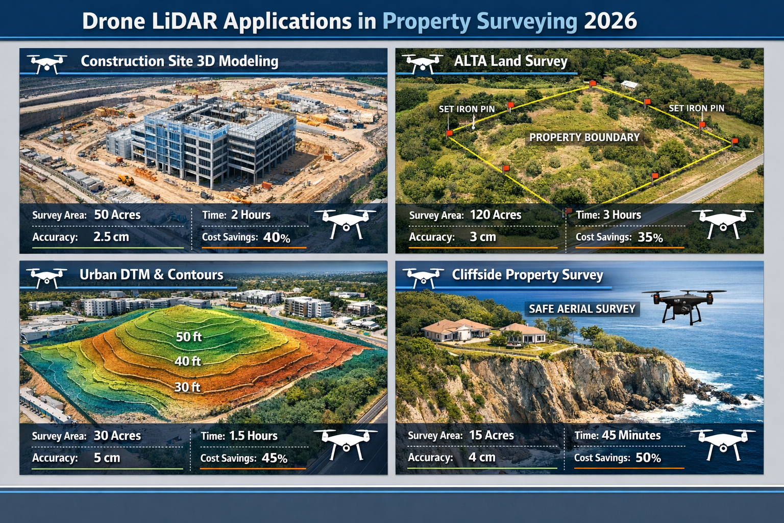
Topographic Surveys for Development
Topographic surveys form the foundation for development planning, engineering design, and construction projects. Accurate elevation data, feature identification, and terrain modeling are essential for:
- Site grading and drainage design
- Building placement and foundation planning
- Infrastructure routing (roads, utilities, drainage)
- Volume calculations for earthwork
- Environmental impact assessment
- Regulatory compliance and permitting
Drone LiDAR technology excels in topographic applications, providing:
Complete Coverage: Unlike ground surveys that measure discrete points, LiDAR creates continuous surface models with millions of data points. This density reveals subtle terrain features that might be missed by traditional methods.
Accurate Contour Mapping: The high-density point clouds enable generation of precise contour maps at any interval, from broad 5-meter contours for regional analysis to detailed 0.1-meter contours for construction design.
3D Visualization: Point cloud data can be rendered as photorealistic 3D models, allowing designers and stakeholders to visualize the site from any angle. These visualizations improve communication and decision-making throughout the project lifecycle.
DTM and DSM Generation: Surveyors can produce both Digital Terrain Models (showing bare ground surface) and Digital Surface Models (including vegetation and structures) from the same dataset, providing multiple analytical perspectives.
ALTA/NSPS Land Title Surveys
ALTA (American Land Title Association) surveys follow rigorous standards for commercial property transactions, requiring detailed documentation of boundaries, improvements, easements, and encumbrances. These surveys support title insurance and inform purchase decisions for commercial properties.
Drone technology enhances ALTA surveys through:
- Comprehensive site documentation: Aerial imagery showing all improvements, parking areas, utilities, and site features
- Accurate improvement location: Precise measurements of buildings, structures, and pavement relative to property boundaries
- Easement verification: Visual confirmation of easement locations and encroachments
- Efficient large-site coverage: Commercial properties spanning multiple acres can be documented thoroughly and efficiently
The combination of drone imagery and traditional ground measurements creates ALTA surveys that exceed standard requirements while reducing project timelines.
Construction Monitoring and As-Built Documentation
Beyond initial surveying, drones provide ongoing value throughout construction projects:
Progress Monitoring: Regular drone flights document construction progress, creating time-stamped records of site conditions. This documentation supports project management, billing verification, and dispute resolution.
Volume Calculations: Earthwork quantities for cut and fill operations can be calculated accurately from drone surveys, enabling precise tracking of material movement and costs.
As-Built Verification: Upon project completion, drone surveys verify that construction matches approved plans, documenting final conditions for facilities management and future reference.
Quality Control: Drone imagery can identify construction defects, drainage issues, or deviations from plans before they become costly problems.
For property owners considering renovations, understanding which property renovations add value can be enhanced by accurate as-built documentation of existing conditions.
Case Study: Mixed-Use Development Survey
A recent mixed-use development project in Surrey demonstrates the comprehensive value of drone LiDAR surveying:
Project Requirements:
- 15-acre site with existing structures to be demolished
- Topographic survey for site planning
- Boundary verification for legal description
- Environmental assessment of drainage patterns
- Documentation for planning permission
Traditional Approach Estimate:
- Duration: 12-15 working days
- Cost: £8,500-£11,000
- Deliverables: Boundary survey, topographic plan, basic site photos
Drone LiDAR Approach:
- Duration: 2 days (6 hours fieldwork, 1.5 days processing)
- Cost: £3,200
- Deliverables: Boundary survey, high-density topographic survey, orthomosaic imagery, 3D point cloud, digital terrain model, contour maps at multiple intervals, volumetric analysis, and comprehensive photographic documentation
The drone approach delivered 62% cost savings, 85% time reduction, and significantly more comprehensive data than traditional methods would have provided. The development team used the detailed 3D models for stakeholder presentations and design visualization, adding value beyond the basic survey requirements.
Limitations and Hybrid Approaches
When LiDAR Has Constraints
Despite its many advantages, drone LiDAR technology is not a universal solution for every surveying challenge. Understanding these limitations ensures appropriate technology selection for each project.
Dense Urban Environments: In heavily built-up areas with tall buildings and narrow streets, GPS signal quality can degrade, affecting positioning accuracy. Buildings also create "shadow" areas where LiDAR cannot capture ground data. In dense urban environments or areas with significant vegetation cover, LiDAR sensors may have penetration limitations[1].
Extremely Dense Vegetation: While LiDAR can penetrate moderate vegetation, extremely dense canopy or thick undergrowth may prevent sufficient laser pulses from reaching the ground surface. In these conditions, ground measurements may still be necessary for critical areas.
Legal Boundary Monuments: Physical boundary markers such as iron pins, concrete monuments, or survey stakes are often too small for LiDAR to detect reliably. Legal boundary surveys still require ground verification of these critical control points.
Underground Features: LiDAR measures surface features and cannot detect underground utilities, buried structures, or subsurface conditions. Ground-penetrating radar or traditional utility location methods remain necessary for these applications.
Weather Limitations: Drones cannot operate safely in high winds, heavy rain, or other adverse weather conditions. While this limitation also affects some traditional methods, it can delay time-sensitive projects.
Regulatory Restrictions: Airspace restrictions near airports, military installations, or other controlled areas may limit or prohibit drone operations. Privacy concerns in residential areas may also require special permissions or operational constraints.
The Value of Hybrid Surveying Methods
Professional surveyors increasingly recognize that a combination of traditional surveying methods and drone LiDAR mapping may be the most effective approach[1] for many projects. This hybrid methodology leverages the strengths of each technique:
Ground Control and Verification: Traditional surveying establishes precise control points that anchor drone data to known coordinates. Ground crews also verify critical measurements and locate features that drones cannot detect.
Boundary Monument Location: While drones capture overall site context, ground surveyors locate and verify physical boundary markers using traditional instruments.
Detailed Feature Surveys: For specific structures or features requiring extreme precision, ground measurements supplement drone data to ensure accuracy meets or exceeds project requirements.
Gap Filling: In areas where drone coverage is limited by obstructions, vegetation, or regulatory constraints, ground surveys fill data gaps to ensure complete site coverage.
Quality Assurance: Ground measurements provide independent verification of drone data accuracy, ensuring deliverables meet professional standards and client specifications.
Selecting the Right Approach
Professional surveyors evaluate multiple factors when determining the optimal surveying approach:
📋 Project Requirements: What accuracy is needed? What deliverables are required? What is the project timeline?
🏗️ Site Characteristics: What is the terrain like? Is there dense vegetation? Are there access restrictions?
⚖️ Legal Considerations: Is this a boundary survey with legal implications? What standards must be met?
💰 Budget Constraints: What resources are available? How do different approaches compare in cost-effectiveness?
⏱️ Timeline Pressures: How quickly are results needed? Can weather delays be accommodated?
The most successful surveying projects in 2026 often combine drone technology for efficient data collection with traditional methods for verification, legal compliance, and detail work. This integrated approach delivers the speed and cost advantages of drones while maintaining the precision and legal defensibility of traditional surveying.
For comprehensive property assessments, professionals may need to consider sourcing extra advice from specialists in various surveying disciplines.
Technology Trends Shaping 2026 and Beyond
Hardware Evolution
The surveying drone industry continues to advance rapidly, with 2026 seeing significant hardware improvements:
Longer Flight Times: Battery technology advances have extended flight times from 20-30 minutes to 45-60 minutes for many surveying platforms, reducing the number of battery changes needed for large sites and improving operational efficiency.
Improved Sensors: LiDAR sensors have become smaller, lighter, and more affordable while maintaining or improving accuracy. This miniaturization allows smaller drones to carry LiDAR payloads, expanding the range of available platforms.
Enhanced Cameras: Integrated camera systems now offer higher resolution, better color accuracy, and improved low-light performance, creating imagery that serves both surveying and marketing purposes.
Obstacle Avoidance: Advanced sensors and AI-powered navigation systems enable drones to detect and avoid obstacles automatically, improving safety and enabling operations in more complex environments.
Modular Payloads: Many professional platforms now support interchangeable sensors, allowing firms to switch between LiDAR, photogrammetry cameras, thermal sensors, or multispectral cameras depending on project requirements.
Software Advancements
Processing and analyzing drone survey data requires sophisticated software, and this field has seen remarkable progress:
Automated Processing: Modern photogrammetry and LiDAR processing software automates much of the workflow, reducing the expertise required and accelerating deliverable production. What once required specialized knowledge can now be accomplished with user-friendly interfaces.
AI-Powered Classification: Artificial intelligence algorithms automatically classify point cloud data into categories (ground, vegetation, buildings, power lines, etc.), dramatically reducing manual editing time.
Cloud Processing: Cloud-based processing platforms enable firms to handle large datasets without investing in expensive local computing infrastructure. Projects can be processed faster using distributed computing resources.
Integration with CAD and BIM: Direct integration between survey processing software and design platforms (AutoCAD, Civil 3D, Revit, etc.) streamlines workflows, allowing designers to work directly with survey data without format conversions.
Mobile Visualization: Tablet and smartphone apps enable field personnel and clients to view and interact with 3D point clouds and models on-site, improving communication and decision-making.
Regulatory Evolution
The regulatory landscape for commercial drone operations continues to mature:
Expanded Operations: Regulatory authorities are gradually relaxing restrictions on beyond-visual-line-of-sight (BVLOS) operations, enabling drones to survey larger areas in single flights.
Standardization: Industry organizations are developing standards for drone surveying accuracy, deliverables, and professional qualifications, creating consistency and professionalism across the sector.
Integration with Airspace Management: New airspace management systems enable better coordination between drone operations and manned aircraft, improving safety and access.
Professional Licensing: Some jurisdictions are developing specialized licensing for drone surveyors, recognizing this as a distinct professional specialty requiring specific knowledge and skills.
Industry Adoption Trends
Industry briefings indicate that 2025 regulatory changes are impacting 2026 operations, with emphasis on technology adoption roadmaps, hardware and software strategies, and competitive positioning[4]. Key adoption trends include:
Mainstream Integration: Drone surveying has moved from experimental to standard practice for many surveying firms. Clients increasingly expect drone capabilities as part of basic service offerings.
Specialization: Some firms are positioning themselves as drone surveying specialists, investing heavily in advanced equipment and expertise to serve complex projects.
Service Expansion: Traditional surveying firms are adding drone capabilities to remain competitive, while some drone service providers are expanding into traditional surveying to offer comprehensive solutions.
Client Education: As technology becomes more accessible, clients are becoming more knowledgeable about drone surveying capabilities and limitations, leading to more sophisticated project specifications.
Data as a Service: Some firms are shifting toward subscription models, providing clients with regular drone surveys and ongoing access to updated data rather than one-time project deliverables.
Understanding what questions to ask during a building survey helps property owners ensure they receive comprehensive information, whether from traditional or drone-enhanced surveying methods.
Choosing a Drone LiDAR Surveying Provider
Essential Qualifications
When selecting a surveying firm offering drone LiDAR services, several qualifications indicate professional competence:
Professional Licensing: The firm should employ licensed surveyors (Chartered Surveyors in the UK, Professional Land Surveyors in the US) who take responsibility for survey accuracy and legal compliance. Drone technology is a tool, but professional judgment and expertise remain essential.
Drone Certifications: Operators should hold appropriate aviation certifications (FAA Part 107 in the US, CAA permissions in the UK) demonstrating they understand aviation regulations and safe operating procedures[1].
Insurance Coverage: Comprehensive liability insurance protects clients from potential issues. Verify that the firm carries adequate coverage for both drone operations and professional surveying services.
Equipment Quality: Professional-grade equipment produces better results than consumer drones. Ask about the specific equipment the firm uses and its capabilities.
Experience and Portfolio: Review the firm's experience with projects similar to yours. Ask for references and examples of completed work.
Questions to Ask Potential Providers
Before engaging a drone surveying firm, consider asking:
-
What accuracy can you achieve for this project? Ensure the firm can meet your specific accuracy requirements.
-
What deliverables will you provide? Clarify exactly what data products, reports, and documentation you'll receive.
-
How long will the project take? Understand the timeline from initial contact through final deliverable delivery.
-
What is your quality control process? Learn how the firm ensures accuracy and catches potential errors.
-
Do you carry professional indemnity insurance? Verify that you're protected if survey errors cause problems.
-
Will you provide ground control and verification? Ensure the firm uses hybrid methods when appropriate rather than relying solely on drone data.
-
What happens if weather delays the survey? Understand how weather contingencies affect timelines and costs.
-
Can you provide the data in formats compatible with our design software? Ensure deliverables will integrate with your workflow.
Understanding Deliverables
Different projects require different deliverables. Common drone survey products include:
- Point Cloud Data: Raw 3D measurement data in formats like LAS or LAZ
- Orthomosaic Images: Geometrically corrected aerial photographs
- Digital Terrain Models (DTM): Bare-earth surface models
- Digital Surface Models (DSM): Models including vegetation and structures
- Contour Maps: Traditional topographic maps with elevation contours
- 3D Mesh Models: Textured 3D models for visualization
- CAD Drawings: Traditional survey plans in AutoCAD or similar formats
- Volume Calculations: Cut/fill quantities for earthwork planning
- Cross-Sections: Elevation profiles along specified lines
Clarify which deliverables are included in the quoted price and which might incur additional costs.
Cost Considerations
Drone survey pricing varies based on multiple factors:
- Site size and complexity
- Required accuracy and point density
- Deliverable requirements
- Site accessibility and location
- Timeline constraints
- Ground control requirements
While drone surveys generally cost less than traditional methods, extremely low quotes may indicate inadequate equipment, insufficient experience, or corners being cut in quality control. Focus on value rather than lowest price, especially for legally critical surveys.
Conclusion: Embracing the Future of Property Surveying
How drones and LiDAR are revolutionizing property surveying in 2026 represents far more than incremental improvement—it marks a fundamental transformation in how professionals gather, analyze, and apply spatial data. The combination of dramatic cost reductions, accelerated timelines, enhanced accuracy, improved safety, and expanded capabilities has created new possibilities for property assessment, development planning, and land management.
The evidence is compelling: surveys that once required weeks and cost thousands can now be completed in days for a fraction of the expense, with equal or superior accuracy. Dangerous fieldwork has been replaced by safe remote operations. Dense vegetation that once blocked surveyors now poses no obstacle to LiDAR sensors. Properties that were too large or complex for comprehensive surveying are now routinely captured in complete detail.
Yet technology alone does not define professional surveying. The most successful applications of drone LiDAR combine cutting-edge tools with traditional expertise, professional judgment, and rigorous quality control. The hybrid approach—leveraging drones for efficient data collection while maintaining ground verification and professional oversight—delivers optimal results for most projects.
Actionable Next Steps
For property owners and developers:
-
Evaluate your surveying needs in light of drone capabilities. Projects that once seemed too expensive or time-consuming may now be feasible.
-
Request drone survey proposals alongside traditional quotes to compare costs, timelines, and deliverables.
-
Ask about hybrid approaches that combine drone efficiency with traditional verification for critical applications.
-
Consider regular monitoring rather than one-time surveys, taking advantage of drone technology's cost-effectiveness for ongoing site documentation.
-
Review past surveys to identify properties where updated drone surveys might reveal valuable information or support better decision-making.
For surveying professionals:
-
Invest in training and equipment to remain competitive as clients increasingly expect drone capabilities.
-
Develop hybrid methodologies that integrate drone technology with traditional expertise rather than viewing them as competing approaches.
-
Stay current with regulations and industry standards as the drone surveying field continues to mature.
-
Educate clients about both capabilities and limitations to set appropriate expectations and deliver optimal solutions.
-
Build partnerships with drone specialists if full in-house capabilities aren't feasible, ensuring you can offer comprehensive services.
The revolution in property surveying is well underway in 2026, but it's far from complete. As technology continues to advance, regulations evolve, and professional practices mature, the gap between traditional and drone-enhanced surveying will only widen. Those who embrace these changes—whether as service providers or consumers—will benefit from better data, faster projects, lower costs, and safer operations.
The question is no longer whether drones and LiDAR will transform property surveying, but how quickly professionals and property owners will adopt these powerful tools to gain competitive advantages and make better-informed decisions about their most valuable assets.
For those seeking comprehensive property assessments that leverage the latest surveying technology alongside traditional expertise, partnering with qualified professionals who understand both modern tools and timeless surveying principles ensures the best possible outcomes. Whether you're considering a Level 3 building survey or need detailed site analysis for development planning, the integration of drone LiDAR technology with professional surveying expertise delivers unprecedented value in 2026 and beyond.
References
[1] Drone Lidar Mapping – https://phoenixlandsurveying.com/arizona-services/drone-lidar-mapping
[2] Lidar Drones – https://uavcoach.com/lidar-drones/
[3] Revolutionizing Land Surveying The Rise Of Drone Technology And Uav Applications In 2026 – https://nottinghillsurveyors.com/blog/revolutionizing-land-surveying-the-rise-of-drone-technology-and-uav-applications-in-2026
[4] Webinar The State Of Drone Surveying A Strategic Briefing For 2026 – https://www.aerotas.com/blog/webinar-the-state-of-drone-surveying-a-strategic-briefing-for-2026