By the end of 2025, Intergeo — the world's largest geospatial conference — had already signaled a seismic shift: 360-degree imagery pipelines fused with AI-driven semantic labeling were no longer experimental. They were production-ready, and the property survey industry was one of the first sectors to feel the impact. The convergence of Gaussian Splatting and Semantic AI: Geospatial Trends Reshaping Property Surveys in 2026 is not a distant promise. It is the operational reality that chartered surveyors, property investors, and asset managers are navigating right now.
This article breaks down what these technologies are, why they matter for property professionals, and how to act on them before competitors do.
Key Takeaways
- 3D Gaussian Splatting converts photographic inputs into photorealistic, navigable 3D scene representations far faster than traditional point-cloud methods.
- Semantic AI layers meaning onto those 3D scenes — identifying roofs, walls, boundaries, vegetation, and defects automatically.
- Research from Xidian University shows that accurate semantic segmentation is achievable with as little as 2% annotated pixel data, dramatically lowering the cost of AI-assisted surveys. [1]
- GeoAI integration is becoming foundational to geospatial workflows in 2026, automating feature extraction and asset condition prediction at scale. [6]
- Property professionals who understand these tools will produce faster, more defensible survey reports and unlock new service lines.
What Is Gaussian Splatting and Why Does It Matter for Property Surveys
From Point Clouds to Photorealistic 3D Scenes
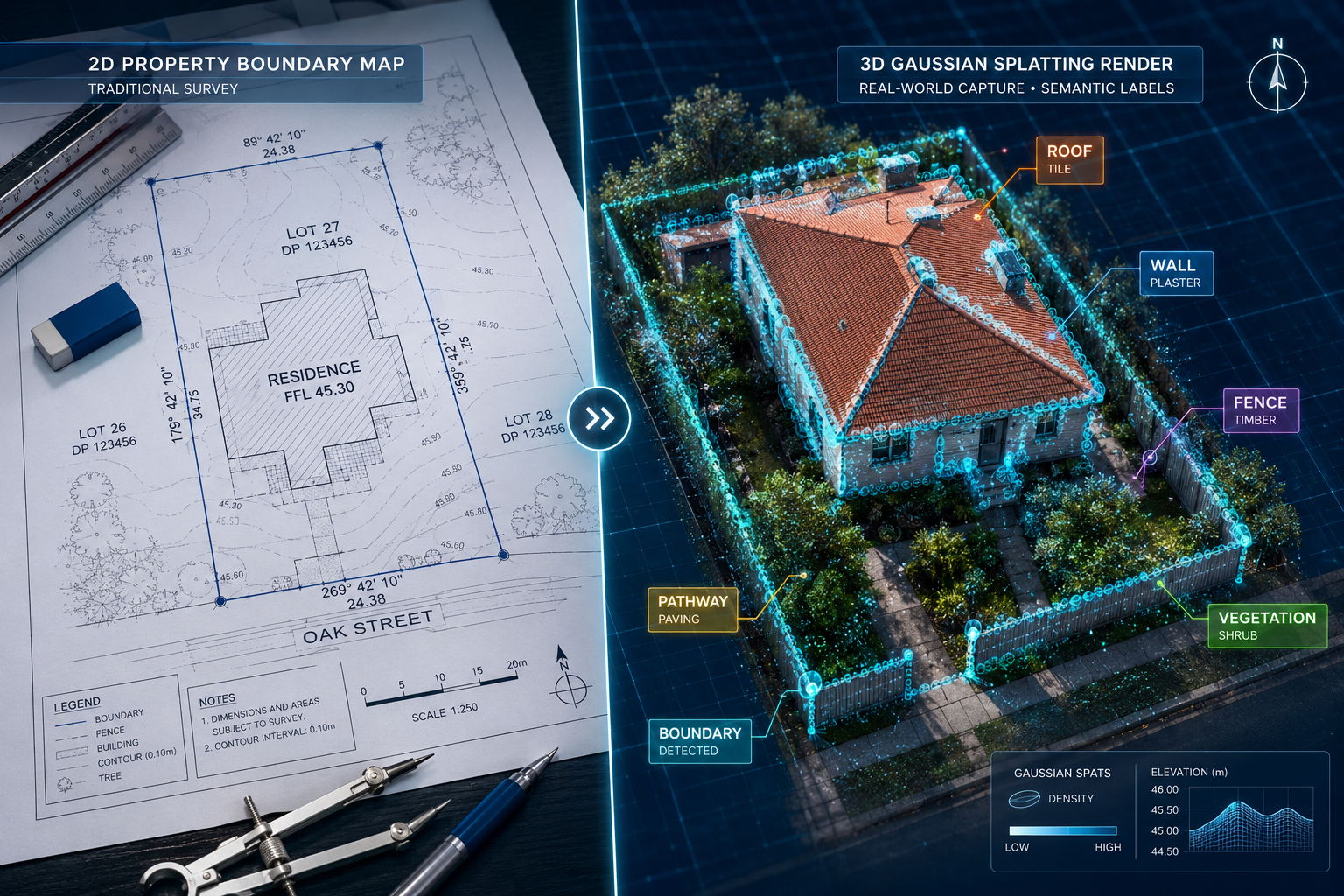
Traditional survey photogrammetry produces point clouds — dense collections of XYZ coordinates that approximate a building's geometry. Useful, but visually flat and computationally heavy to process. 3D Gaussian Splatting (3DGS) takes a fundamentally different approach. Instead of points, it represents a scene as millions of tiny, semi-transparent ellipsoids — "Gaussians" — each carrying color, opacity, and orientation data. The result is a photorealistic, real-time-renderable 3D model that can be generated from standard camera footage, including drone-captured 360-degree imagery. [10]
For property surveys, this is significant. A surveyor flying a drone around a Victorian terrace can now generate a navigable, photorealistic model of that building within hours — not days. Clients can walk through the model remotely. Defects are visible in context. Boundary lines can be overlaid with precision.
Recent surveys of 3DGS applications confirm its versatility across segmentation, editing, and high-fidelity rendering, with real-time performance that was unachievable with earlier neural radiance field (NeRF) approaches. [8] Surface reconstruction studies have further mapped out structured methodologies for converting Gaussian representations into measurable, watertight meshes — the kind surveyors need for legal documentation. [9]
The Role of 360-Degree Imagery from Intergeo 2025
Intergeo 2025 placed heavy emphasis on 360-degree capture workflows as the primary data input for next-generation geospatial models. The key insight from the conference was that omnidirectional cameras — mounted on drones, vehicles, or handheld rigs — provide the overlapping image coverage that Gaussian Splatting algorithms need to reconstruct scenes accurately. When combined with semantic AI pipelines, these inputs allow automated identification of structural elements, boundaries, and potential defects without manual annotation of every image frame.
For surveyors considering upgrading their toolkit, premium drone survey services now represent a direct entry point into this technology stack.
How Semantic AI Transforms Raw 3D Models into Actionable Survey Data
Semantic Segmentation: Giving the Model a Vocabulary
A photorealistic 3D model of a property is impressive. A semantically segmented model is genuinely useful. Semantic AI assigns category labels to every part of a scene — roof tiles, chimney stacks, window frames, boundary walls, vegetation, damp patches — enabling automated measurement, condition scoring, and defect flagging.
The challenge has historically been data annotation. Training a semantic AI model requires labeling thousands of images, which is expensive and slow. A breakthrough from Xidian University's EvoPropGS research addresses this directly: by exploiting structural repetitions common in aerial environments (rows of identical roof tiles, repeating facade elements), the system propagates semantic labels from just 2% of annotated pixels to achieve high-accuracy segmentation across an entire scene. [1] This makes AI-assisted property surveys economically viable at scale.
GS3LAM: Real-Time Semantic Mapping in the Field
One of the most practically relevant developments for 2026 is GS3LAM, a framework that processes multimodal sensor data — cameras, LiDAR, depth sensors — to render consistent, dense semantic maps in real time. [3] GS3LAM models scenes as "Semantic Gaussian Fields" and jointly optimizes camera positioning and scene representation simultaneously, which is critical when a drone is moving around a complex building.
For a surveyor, this means the semantic map is being built and refined as the drone flies — not as a post-processing step that takes hours. Tracking robustness is improved because the system corrects its own positional errors using semantic consistency checks. The practical output is a survey-ready semantic model delivered far faster than any traditional workflow.
"The integration of AI and machine learning into geospatial workflows is becoming foundational — automating feature extraction, asset condition prediction, and map production at a scale previously impossible." [6]
GeoAI and the Automation of Feature Extraction
Beyond individual building surveys, GeoAI — the application of machine learning to spatial data — is reshaping how entire property portfolios are assessed. According to geospatial industry analysis for 2026, GeoAI workflows now automate tasks including boundary detection, vegetation encroachment identification, drainage pattern mapping, and structural change detection between survey epochs. [6]
This matters for building pathology assessments, where identifying the pattern and progression of defects — rising damp, subsidence cracking, roof deterioration — benefits enormously from AI systems that can compare current survey data against historical baselines automatically.
Geospatial Trends Reshaping Property Surveys in 2026: Urban Scale to Individual Property
City-Scale Semantic Models and Their Survey Implications
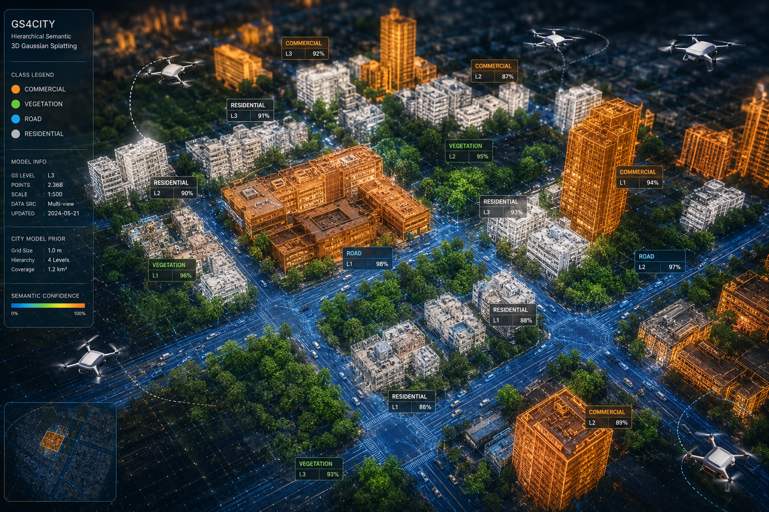
The Gaussian Splatting and Semantic AI: Geospatial Trends Reshaping Property Surveys in 2026 story extends well beyond individual buildings. GS4City, a hierarchical semantic Gaussian Splatting framework, incorporates city-model priors — existing 3D city databases, cadastral maps, building footprint data — into the Gaussian scene representation. [4] The result is a semantic 3D model that understands not just what a building looks like, but where it sits within the urban fabric, what its legal boundaries are, and how it relates to neighboring structures.
For property surveyors, this has direct implications for:
- Boundary dispute resolution — semantic models can overlay Land Registry data onto photorealistic 3D scenes for precise comparison
- Party wall assessments — structural relationships between adjoining properties become visually and measurably clear
- Development appraisals — understanding a site's relationship to transport links, environmental constraints, and neighboring uses
Those working on party wall matters or basement and party wall surveying in complex urban areas will find city-scale semantic models particularly valuable for pre-survey analysis.
Collaborative Semantic Occupancy: Multi-Source Data Fusion
A Purdue University and NYU Abu Dhabi study introduced a vision-only method using sparse 3D semantic Gaussian Splatting for collaborative 3D semantic occupancy prediction. [2] Originally developed for connected vehicle systems, the underlying principle — fusing semantic 3D data from multiple capture sources to build a more complete scene understanding — translates directly to property survey contexts where multiple drone passes, ground-level photography, and existing cadastral data must be reconciled.
This multi-source fusion approach reduces the communication and processing overhead of sharing raw point clouds between systems, replacing them with compact semantic Gaussian representations. For survey firms managing large portfolios, this means faster data exchange between field teams and office-based analysts.
Key Geospatial Trends Shaping the Survey Industry in 2026
The broader geospatial landscape in 2026 is being driven by several converging forces [5][6]:
| Trend | Survey Application | Maturity Level |
|---|---|---|
| AI-automated feature extraction | Defect identification, boundary detection | Production-ready |
| 3D Gaussian Splatting rendering | Photorealistic property models | Rapidly maturing |
| Semantic segmentation at scale | Automated condition scoring | Early production |
| LiDAR + camera fusion | Precise dimensional measurement | Established |
| City-model prior integration | Urban development appraisals | Emerging |
| Real-time SLAM mapping | Field-based semantic surveys | Emerging |
Practical Implications for Chartered Surveyors and Property Professionals
What Changes in the Survey Workflow
The traditional building survey process involves physical inspection, manual note-taking, photographic documentation, and report writing — a workflow that has changed relatively little in decades. Gaussian Splatting and semantic AI do not eliminate the surveyor's judgment, but they fundamentally change the data collection and analysis phases.
Before the site visit: AI systems can pre-process aerial imagery, satellite data, and existing cadastral records to generate a preliminary semantic model of the property. The surveyor arrives with a structured understanding of likely defect locations and boundary complexities.
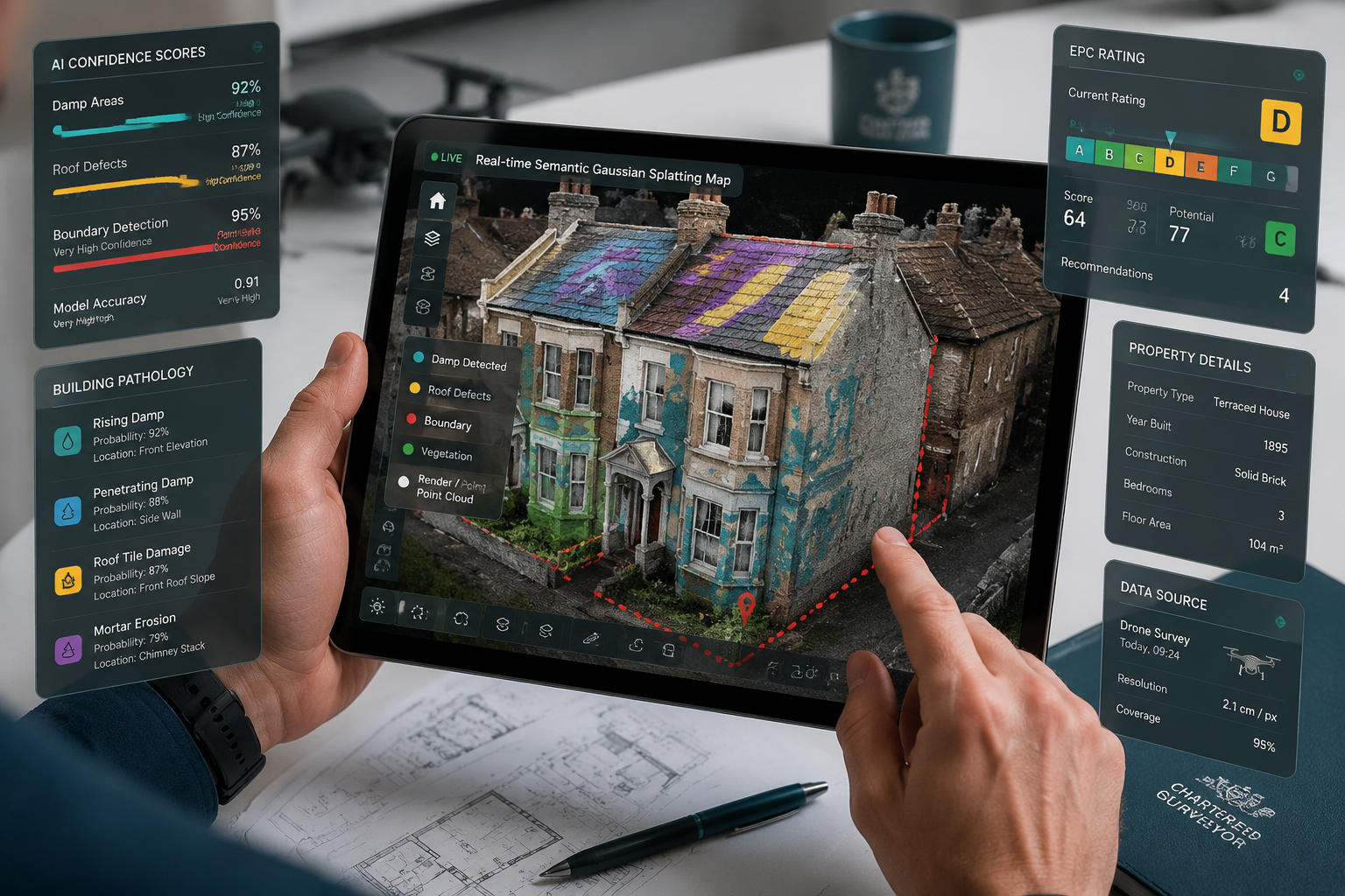
During the survey: Drone-captured 360-degree footage feeds into real-time semantic mapping (GS3LAM-style workflows), flagging areas of concern as the inspection proceeds. The surveyor focuses expert attention on AI-identified anomalies rather than systematically photographing every surface.
After the survey: The semantic 3D model becomes the evidential backbone of the report. Clients receive not just a PDF but an interactive, navigable model with annotated defects — a significant step up from static photographs.
For surveyors wondering what questions to ask during a building survey, semantic AI effectively answers many of the observational questions automatically, freeing the surveyor to focus on interpretation and advice.
Intellectual Property and Data Governance Considerations
As 3DGS models acquire commercial value — a photorealistic semantic model of a property portfolio is a significant asset — intellectual property protection becomes a genuine concern. Research published in 2026 is actively developing mechanisms to safeguard 3DGS assets against unauthorized reproduction or manipulation in the era of generative AI. [7]
For survey firms, this raises practical questions:
- Who owns the semantic 3D model of a property — the surveyor, the client, or the data platform?
- How are models stored, shared, and protected against unauthorized use?
- What are the liability implications if an AI-generated semantic label is incorrect and informs a purchase decision?
These governance questions are not yet resolved industry-wide, but firms that establish clear data ownership policies now will be better positioned as regulation catches up with technology. Understanding environmental issues flagged by AI systems also requires careful validation before inclusion in formal survey reports.
Survey Types and the Technology Fit
Not every survey type benefits equally from Gaussian Splatting and semantic AI. The table below maps technology fit to common survey categories:
| Survey Type | Technology Benefit | Priority Adoption |
|---|---|---|
| Level 3 Full Building Survey | High — defect detection, condition scoring | High |
| Drone/Aerial Survey | Very high — primary data capture method | Immediate |
| New Build Snagging | Medium — systematic defect cataloguing | Medium |
| Valuation Survey | Medium — comparable data enrichment | Medium |
| Level 2 HomeBuyer Report | Lower — cost/benefit less clear at this level | Lower |
For clients deciding between survey levels, the complete guide to choosing between Level 2 and Level 3 surveys remains a useful starting point, though the gap between what each level can deliver is narrowing as AI tools become standard at the higher end.
Conclusion
The convergence of Gaussian Splatting and Semantic AI: Geospatial Trends Reshaping Property Surveys in 2026 represents the most significant methodological shift in property surveying since the introduction of digital photography. The research is clear: semantic segmentation of 3D scenes is now achievable with minimal annotation overhead [1], real-time semantic mapping in the field is operationally viable [3], and city-scale semantic models are beginning to integrate with cadastral and planning data in ways that directly serve surveyors and property professionals [4].
Actionable next steps for property professionals:
- Audit your current data capture toolkit. If drone surveys are not already part of your service offering, 2026 is the year to integrate them — the semantic AI layer depends on high-quality 360-degree input data.
- Evaluate semantic AI platforms. Several commercial platforms now offer Gaussian Splatting pipelines with semantic labeling. Pilot one on a complex property before committing to full workflow integration.
- Establish data governance policies. Define ownership, storage, and liability frameworks for semantic 3D models before client disputes arise.
- Invest in staff training. Semantic AI augments surveyor judgment — it does not replace it. Staff need to understand model outputs well enough to validate, challenge, and explain AI-generated findings.
- Monitor regulatory developments. Intellectual property frameworks for 3DGS assets are evolving rapidly [7]. Engage with RICS guidance and industry bodies to stay ahead of compliance requirements.
The surveyors who treat Gaussian Splatting and semantic AI as core competencies — rather than optional add-ons — will define the professional standard for property surveys in the years ahead.
References
[1] EvoPropGS for Aerial Semantic 3D Gaussian Splatting – https://ojs.aaai.org/index.php/AAAI/article/view/42418?utm_source=openai
[2] Vision-Only Gaussian Splatting for Collaborative Semantic Occupancy Prediction – https://ojs.aaai.org/index.php/AAAI/article/view/37269?utm_source=openai
[3] GS3LAM: Gaussian Semantic Splatting SLAM – https://arxiv.org/abs/2603.27781?utm_source=openai
[4] GS4City: Hierarchical Semantic Gaussian Splatting via City-Model Priors – https://arxiv.org/abs/2604.11401?utm_source=openai
[5] Mapping The Future Critical Geospatial Trends For 2026 – https://lidarmag.com/2026/02/16/mapping-the-future-critical-geospatial-trends-for-2026/?utm_source=openai
[6] Geospatial Trends 2026 – https://www.survtechsolutions.com/post/geospatial-trends-2026?utm_source=openai
[7] Intellectual Property Protection for 3D Gaussian Splatting Assets – https://arxiv.org/abs/2602.03878?utm_source=openai
[8] Advancements in 3D Gaussian Splatting Applications – https://huggingface.co/papers/2508.09977?utm_source=openai
[9] Surface Reconstruction Using 3D Gaussian Splatting – https://pubmed.ncbi.nlm.nih.gov/40989489/?utm_source=openai
[10] 3D Gaussian Splatting as a New Era – https://pubmed.ncbi.nlm.nih.gov/38713572/?utm_source=openai