The construction industry stands at a critical crossroads in 2026, where every development decision carries profound environmental consequences. Modern surveying tools now capture ecological data and forecast environmental impacts before ground is broken, positioning surveyors as key advisors in environmentally conscious development projects. Ecological Impact Assessment in Property Surveys: How Surveyors Support Sustainable Development Decisions has evolved from a regulatory checkbox into a sophisticated, technology-driven process that shapes how we build, where we build, and what environmental legacy we leave behind.
Gone are the days when property surveys focused solely on boundaries, structures, and monetary valuations. Today's chartered surveyors integrate advanced ecological assessment methodologies into their standard practice, utilizing drone technology, GIS mapping, and biodiversity metrics to provide comprehensive environmental intelligence. This transformation reflects both regulatory imperatives and market demand for sustainable development that protects natural capital while enabling economic growth.
Key Takeaways
- Ecological Impact Assessments (EcIA) are now mandatory for most UK developments, with Biodiversity Net Gain requirements demanding a minimum 10% improvement in habitat value since 2024[3]
- Surveyors play a crucial coordination role between ecologists, developers, and planning authorities, ensuring environmental data informs design decisions from the earliest project stages[2]
- Modern surveying technology including drones, thermal imaging, and GIS platforms enables comprehensive ecological data collection that was impossible just five years ago[4]
- Assessment costs range significantly from £1,500-£5,000 for Biodiversity Net Gain Assessments to £3,000-£10,000 for comprehensive EcIAs, depending on site complexity and survey requirements[3]
- Timing is critical as ecological survey data remains valid for only two years for planning purposes, and many species surveys must occur within strict seasonal windows[2]
Understanding Ecological Impact Assessment in Property Surveys

What Is an Ecological Impact Assessment?
An Ecological Impact Assessment (EcIA) represents a systematic process through which potential environmental impacts of a proposed development are identified, quantified, assessed, and ultimately mitigated or compensated. The process involves professional ecologists determining which ecological features will be affected by development activities and what additional specialized surveys are required to fully understand those impacts[2].
The EcIA framework examines three distinct categories of environmental impact:
Direct Impacts 🏗️
- Permanent habitat loss through site clearance
- Destruction of breeding sites or shelter
- Removal of food sources for protected species
- Physical alteration of landscape features
Indirect Impacts 🌊
- Water pollution affecting downstream ecosystems
- Air quality degradation impacting sensitive habitats
- Noise and vibration disturbing wildlife
- Light pollution disrupting nocturnal species behavior
- Changes to hydrology affecting wetland systems
Cumulative Impacts 📊
- Combined effects with other nearby developments
- Incremental habitat fragmentation
- Population-level impacts on species
- Long-term ecosystem degradation trends[3]
This comprehensive approach ensures that development decisions account for the full spectrum of environmental consequences, not merely the obvious on-site impacts.
The Legal Framework Driving Ecological Assessments
The regulatory landscape governing ecological assessments has undergone dramatic transformation in recent years. In the United Kingdom, the Biodiversity Net Gain (BNG) Assessment became a mandatory legal requirement for eligible developments in 2024, fundamentally changing how surveyors and developers approach site evaluation[3].
Under BNG legislation, developments must demonstrate a minimum 10% net gain in biodiversity value compared to the pre-development baseline. This requirement applies a quantifiable metric to environmental protection, moving beyond vague commitments to measurable habitat improvement.
In the United States, environmental review requirements stem from multiple regulatory frameworks:
| Regulatory Trigger | Governing Legislation | Scope |
|---|---|---|
| Federal funding or permits | National Environmental Policy Act (NEPA) | Comprehensive environmental impact statements |
| Wetlands or waterways | Clean Water Act Section 404 | Wetland delineation and mitigation |
| Endangered species | Endangered Species Act | Habitat assessment and species surveys |
| State-level projects (California) | California Environmental Quality Act (CEQA) | State environmental impact reports |
| State-level projects (New York) | State Environmental Quality Review Act (SEQRA) | State environmental assessments[1] |
The February 2026 release of the 11th edition of ALTA/NSPS standards by the American Land Title Association and National Society of Professional Surveyors includes updated guidelines that reflect the growing importance of environmental considerations in property surveys[5][6].
How Surveyors Integrate Ecological Assessments
Professional surveyors serve as the critical link between ecological specialists, developers, planning authorities, and other stakeholders. While surveyors typically don't conduct the specialized ecological fieldwork themselves, they coordinate the assessment process and integrate environmental findings into comprehensive property reports.
When conducting Level 3 full building surveys that address environmental issues, chartered surveyors identify potential ecological constraints early in the project timeline. This proactive approach prevents costly delays and design revisions later in the development process.
The surveyor's role includes:
✅ Initial Site Reconnaissance – Identifying obvious ecological features requiring specialist assessment
✅ Coordination – Commissioning and managing ecological consultants
✅ Data Integration – Incorporating ecological findings into measured building surveys and site plans
✅ Risk Assessment – Flagging environmental constraints that may affect development viability
✅ Stakeholder Communication – Translating technical ecological data for clients and planning authorities
✅ Timeline Management – Ensuring surveys occur within appropriate seasonal windows[2]
This integrated approach ensures that ecological considerations inform decision-making from the earliest feasibility stages through to final planning applications.
The Ecological Impact Assessment Process for Property Development
Phase 1: Preliminary Ecological Appraisal and Desk Study
Every comprehensive ecological assessment begins with a Preliminary Ecological Appraisal (PEA), also known as a Phase 1 Habitat Survey. This initial investigation establishes the baseline ecological conditions and identifies whether more detailed surveys are necessary[2].
The desk study component involves reviewing existing environmental data:
- Statutory designation records (Sites of Special Scientific Interest, Special Areas of Conservation, National Nature Reserves)
- Non-statutory wildlife sites (Local Wildlife Sites, Ancient Woodland Inventory)
- Protected species records from local biological record centers
- Historical habitat maps and aerial photography
- Previous ecological surveys conducted within the site vicinity
- Hydrological data including watercourse locations and flood zones
- Soil surveys and geological information
Following the desk study, ecologists conduct a field walkover survey to ground-truth the desktop findings. During this site visit, they:
🔍 Map habitat types using standardized classification systems
🔍 Identify potential protected species presence through field signs
🔍 Assess habitat quality and connectivity
🔍 Locate features with ecological value (hedgerows, ponds, veteran trees)
🔍 Photograph representative habitats and notable features
🔍 Evaluate the site context within the wider landscape[2]
The PEA concludes with recommendations for Phase 2 surveys if protected species or valuable habitats are likely present. This staged approach ensures resources are focused where genuine ecological constraints exist, rather than conducting expensive surveys unnecessarily.
When surveyors commission these preliminary assessments as part of comprehensive property surveys, they provide clients with early warning of potential ecological obstacles that could affect development timelines or design options.
Phase 2: Detailed Species and Habitat Surveys
If the preliminary appraisal identifies potential protected species or priority habitats, Phase 2 surveys become necessary. These detailed investigations follow strict methodological protocols and must occur within specific seasonal windows, making timing absolutely critical[2].
Common Phase 2 Survey Types:
Bat Surveys 🦇
- Activity surveys (May-September)
- Roost assessments requiring multiple visits
- Emergence and re-entry surveys at dusk/dawn
- Static detector deployment for activity patterns
Great Crested Newt Surveys
- Presence/absence surveys (mid-March to mid-June)
- Population size class assessment
- Habitat suitability index evaluation
- eDNA water sampling as preliminary screening
Breeding Bird Surveys
- Territory mapping visits (April-June)
- Multiple visits to establish breeding status
- Dawn surveys when bird activity peaks
- Winter bird surveys for some species
Reptile Surveys
- Artificial refuge surveys (April-September)
- Multiple survey visits under specific weather conditions
- Population size class assessment
Botanical Surveys
- National Vegetation Classification surveys
- Rare plant species searches
- Timing dependent on flowering periods
Badger Surveys
- Sett location and activity assessment
- Possible throughout the year
- Follow-up monitoring if active setts found
The seasonal constraints of Phase 2 surveys create significant planning implications. A site purchased in autumn may require waiting until the following spring before bat surveys can commence, potentially delaying planning applications by 6-12 months. Professional surveyors alert clients to these timing issues during initial property inspections, preventing unrealistic project schedules.
Survey data validity represents another critical consideration. For planning purposes, ecological survey data typically remains valid for up to two years. However, for most species licenses, data must be obtained during the most recent survey season, requiring updated surveys if development timelines extend[2].
Phase 3: Impact Assessment and Mitigation Hierarchy
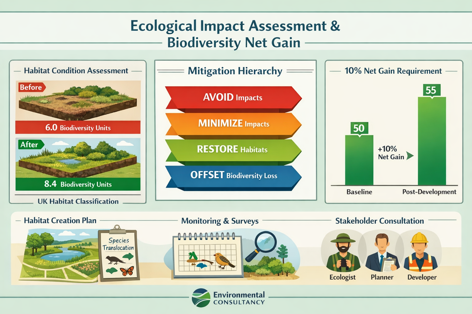
Once baseline ecological conditions are established through Phase 1 and Phase 2 surveys, ecologists assess how the proposed development will affect identified ecological features. This assessment follows the established mitigation hierarchy:
1. Avoidance (Highest Priority)
- Redesigning development to avoid sensitive habitats entirely
- Adjusting site layouts to retain key ecological features
- Timing construction to avoid sensitive breeding seasons
- Establishing protective buffer zones around retained habitats
2. Minimization
- Reducing the development footprint
- Implementing pollution prevention measures
- Using sensitive lighting design to minimize disturbance
- Employing best-practice construction methods
3. Restoration
- Reinstating temporarily disturbed habitats
- Enhancing degraded habitats on-site
- Improving habitat connectivity
- Removing invasive species
4. Compensation/Offsetting (Last Resort)
- Creating new habitats to replace those lost
- Off-site habitat creation when on-site is impossible
- Biodiversity offsetting schemes
- Financial contributions to conservation projects[3]
This hierarchy ensures that genuine impact avoidance is prioritized over simply compensating for environmental damage. The approach reflects the principle that existing, functioning ecosystems have greater ecological value than newly created habitats that may take decades to reach equivalent quality.
Surveyors working on planning applications collaborate with design teams to incorporate mitigation measures into site layouts and construction specifications. This integration ensures that environmental commitments are practical, deliverable, and adequately costed within project budgets.
Phase 4: Biodiversity Net Gain Calculation and Reporting
The 2024 introduction of mandatory Biodiversity Net Gain (BNG) requirements fundamentally changed ecological assessment in the UK. Developments must now demonstrate a minimum 10% improvement in biodiversity value using the standardized Defra Biodiversity Metric[3].
The BNG calculation process involves:
Baseline Assessment
- Mapping all habitat types using UK Habitat Classification
- Assessing habitat condition (poor, moderate, good)
- Calculating habitat distinctiveness scores
- Determining strategic significance
- Generating baseline biodiversity units
Post-Development Assessment
- Mapping proposed habitats after development
- Projecting habitat condition trajectories
- Accounting for time-to-target condition
- Calculating post-development biodiversity units
Net Gain Calculation
- Comparing post-development to baseline units
- Demonstrating minimum 10% uplift
- Accounting for habitat creation, enhancement, and loss
- Addressing on-site and off-site contributions[3]
The Defra metric applies different multipliers based on habitat type, condition, and strategic importance. For example, creating species-rich grassland on a site previously dominated by amenity grassland generates more biodiversity units than simply maintaining existing low-value habitats.
Typical BNG Assessment Costs:
| Assessment Type | Cost Range | Included Services |
|---|---|---|
| Biodiversity Net Gain Assessment | £1,500 – £5,000 | Baseline survey, Defra metric application, habitat management plan |
| Comprehensive Ecological Impact Assessment | £3,000 – £10,000 | Multi-season surveys, full impact assessment, mitigation design |
| Protected Species Surveys (individual) | £500 – £3,000 | Species-specific surveys following standard protocols[3] |
These costs represent significant project expenses, particularly for smaller developments. However, early investment in quality ecological assessment prevents far more expensive problems during the planning process or construction phase.
Professional surveyors help clients understand these cost implications when budgeting for property development and restoration projects, ensuring adequate financial provision for environmental compliance.
How Surveyors Support Sustainable Development Decisions Through Ecological Data
Technology Integration: Drones, GIS, and Environmental Monitoring
The surveying profession has embraced technological innovation to enhance ecological assessment capabilities. In 2026, surveyors routinely deploy advanced tools that would have seemed futuristic just a decade ago, fundamentally changing how environmental data is collected, analyzed, and communicated[4].
Drone Technology for Ecological Surveys 🚁
Premium drone surveys now offer unprecedented ecological intelligence:
- Habitat Mapping – High-resolution aerial imagery enables precise habitat classification across large sites
- Thermal Imaging – Identifies bat roosts, badger setts, and other features invisible to conventional photography
- Vegetation Health Analysis – Multispectral cameras assess plant vigor and identify invasive species
- Topographic Modeling – Creates detailed elevation models showing drainage patterns and hydrological connectivity
- Inaccessible Area Surveys – Safely surveys cliff faces, dense vegetation, and other challenging terrain
- Temporal Monitoring – Repeated flights document habitat changes over time
The ability to survey extensive sites rapidly and comprehensively has dramatically improved baseline data quality while reducing survey costs and timelines.
Geographic Information Systems (GIS) Integration
Modern surveyors utilize GIS platforms to integrate multiple data layers:
✓ Ecological survey findings
✓ Statutory and non-statutory designations
✓ Protected species records
✓ Habitat connectivity analysis
✓ Environmental constraints
✓ Development proposals
✓ Mitigation measure locations
This spatial integration enables sophisticated analysis of how proposed developments interact with ecological features. Surveyors can model habitat connectivity, identify critical wildlife corridors, and optimize site layouts to minimize environmental impacts.
Real-Time Environmental Monitoring
Emerging technologies enable continuous environmental monitoring:
- Acoustic monitoring for bat and bird activity
- Camera traps documenting wildlife movement patterns
- Water quality sensors providing continuous pollution monitoring
- Weather stations recording microclimate conditions
- Soil moisture sensors tracking hydrological changes
This real-time data supports adaptive management approaches, allowing mitigation measures to be refined based on actual environmental performance rather than theoretical predictions.
The integration of these technologies positions surveyors as sophisticated environmental data specialists, not merely measurement technicians. As regulatory requirements become more stringent, this technological capability becomes increasingly valuable to developers navigating complex environmental compliance[4].
Coordinating Multi-Disciplinary Teams for Environmental Compliance
Ecological Impact Assessment in Property Surveys: How Surveyors Support Sustainable Development Decisions fundamentally depends on effective coordination between diverse specialists. Surveyors serve as the central hub connecting:
Ecologists – Conducting specialized surveys and impact assessments
Landscape Architects – Designing habitat creation and enhancement schemes
Planning Consultants – Navigating regulatory requirements and planning policy
Engineers – Implementing pollution prevention and drainage solutions
Arboriculturists – Assessing tree impacts and retention strategies
Hydrologists – Evaluating water resource impacts
Archaeologists – Addressing heritage constraints alongside ecological issues
This coordination role requires surveyors to understand the technical requirements and methodologies of each discipline while maintaining focus on overall project objectives.
"The modern surveyor must speak multiple professional languages fluently – translating ecological constraints into design opportunities, regulatory requirements into practical solutions, and environmental risks into informed business decisions."
When conducting measured building surveys, surveyors ensure that ecological data is captured at appropriate detail levels and integrated with architectural, structural, and services information. This holistic approach prevents the common problem of environmental considerations being "bolted on" late in the design process when options for meaningful mitigation have been foreclosed.
Early-Stage Site Assessment and Feasibility Studies
The greatest value surveyors provide in supporting sustainable development decisions occurs during early-stage feasibility assessment, before significant design investment or land acquisition commitments.
Pre-Purchase Ecological Due Diligence
Smart developers commission preliminary ecological assessments before purchasing development sites. This due diligence reveals:
⚠️ Deal-Breaker Constraints – Protected species or habitats that may prevent development entirely
⚠️ Significant Cost Implications – Expensive mitigation requirements affecting project viability
⚠️ Timeline Risks – Seasonal survey requirements that could delay planning applications
⚠️ Design Constraints – Ecological features requiring specific site layout adaptations
⚠️ Opportunity Identification – Existing habitats that could contribute to BNG requirements
Surveyors incorporating ecological screening into initial site assessments provide clients with realistic expectations about environmental compliance costs and timelines. This transparency prevents the common scenario where ecological constraints emerge late in the planning process, forcing expensive redesigns or even project abandonment.
Optimizing Site Selection
When clients are choosing between multiple potential development sites, comparative ecological assessment helps inform selection:
| Site Factor | Site A | Site B | Site C |
|---|---|---|---|
| Protected species presence | Moderate (bats) | High (GCN, bats) | Low |
| Statutory designations | None within 500m | SSSI adjacent | None within 2km |
| Habitat quality | Moderate | High | Poor |
| BNG baseline units | 12 units | 28 units | 6 units |
| Estimated ecological costs | £8,000 | £25,000 | £3,500 |
| Survey timeline | 6 months | 12 months | 3 months |
| Development risk | Medium | High | Low |
This comparative analysis enables evidence-based site selection that balances environmental constraints against other commercial considerations.
Negotiation Support and Planning Applications
Once ecological assessments are complete, surveyors support clients through the planning application process, where environmental considerations often become negotiation points with local planning authorities.
Presenting Ecological Evidence Effectively
Planning committees and case officers may lack technical ecological expertise, making clear communication essential. Surveyors help translate complex ecological reports into accessible summaries highlighting:
- Compliance demonstration – How proposals meet BNG and other environmental requirements
- Mitigation effectiveness – Evidence supporting proposed environmental measures
- Monitoring commitments – Long-term habitat management and monitoring plans
- Enhancement opportunities – Positive environmental outcomes beyond minimum requirements
Responding to Ecological Objections
When statutory consultees (Natural England, local wildlife trusts) or community groups raise ecological objections, surveyors coordinate technical responses:
- Clarifying misunderstandings about survey methodologies or findings
- Providing additional information addressing specific concerns
- Proposing enhanced mitigation to overcome objections
- Commissioning supplementary surveys if data gaps are identified
- Negotiating planning conditions that satisfy all parties
This negotiation support often makes the difference between planning approval and refusal, particularly for sites with genuine but manageable ecological constraints.
Professional surveyors also advise on the potential for negotiating property prices based on survey findings, including environmental remediation costs that may not have been apparent during initial site inspections.
Long-Term Monitoring and Adaptive Management
Ecological obligations don't end when planning permission is granted. Most developments with significant environmental mitigation require long-term monitoring and management, often spanning 30 years or more.
Habitat Management and Monitoring Plans (HMMP)
BNG requirements mandate detailed HMMPs specifying:
📋 Habitat creation specifications – Planting schedules, seed mixes, substrate requirements
📋 Management prescriptions – Mowing regimes, scrub control, invasive species management
📋 Monitoring protocols – Survey methods, frequency, success criteria
📋 Reporting requirements – Annual reports to planning authorities
📋 Remedial actions – Contingency measures if habitats fail to develop as predicted
📋 Responsible parties – Clear allocation of management responsibilities
📋 Funding mechanisms – Financial provision for decades-long management[3]
Surveyors help clients understand the long-term cost implications of these commitments and ensure adequate financial provision is made. For residential developments, this often involves establishing management companies or contributing to local authority biodiversity offsetting schemes.
Adaptive Management Approaches
Ecological systems are inherently unpredictable, and habitat creation doesn't always proceed as planned. Adaptive management frameworks allow mitigation measures to be refined based on monitoring results:
- Baseline monitoring – Establishing initial conditions post-construction
- Regular surveys – Tracking habitat development and species colonization
- Performance assessment – Comparing actual outcomes against predicted trajectories
- Intervention triggers – Defined thresholds requiring management adjustments
- Remedial actions – Corrective measures when habitats underperform
- Reporting and review – Regular stakeholder updates and plan refinements
This iterative approach recognizes that environmental outcomes cannot be guaranteed through initial design alone, requiring ongoing attention and adjustment.
Surveyors involved in property management and inspection services increasingly incorporate ecological monitoring into their service offerings, providing clients with integrated property and environmental stewardship.
Regional Variations and Case Study Applications
UK Context: Biodiversity Net Gain Implementation
The UK's mandatory BNG regime represents one of the world's most ambitious attempts to halt biodiversity decline through the planning system. Implementation in 2024 created significant challenges and opportunities for the surveying profession.
Regional Planning Authority Approaches
Different local planning authorities have adopted varying approaches to BNG enforcement:
Stringent Authorities (London boroughs, National Park areas)
- Require BNG assessments for minor developments below statutory thresholds
- Demand higher net gain percentages (15-20%) in local policies
- Scrutinize metric calculations closely
- Favor on-site habitat creation over off-site offsetting
Pragmatic Authorities (Many county councils)
- Apply statutory minimum requirements
- Accept standard metric calculations without extensive challenge
- Support off-site offsetting when on-site provision is impractical
- Focus on major developments rather than minor applications
Under-Resourced Authorities (Some smaller districts)
- Lack in-house ecological expertise to assess submissions
- Rely heavily on statutory consultee advice
- May accept weaker BNG proposals due to limited scrutiny capacity
- Create uncertainty about assessment standards
Surveyors operating across multiple authority areas must understand these regional variations and tailor BNG submissions accordingly. What satisfies planning officers in one authority may prove inadequate in another, despite identical legal requirements.
Habitat Banking and Offsetting Markets
The BNG requirement has stimulated development of biodiversity offsetting markets where landowners create and sell biodiversity units to developers unable to achieve net gain on-site.
Emerging market characteristics include:
💷 Unit pricing – £15,000-£42,000 per biodiversity unit depending on habitat type and location
💷 Geographic proximity – Planning authorities prefer offsetting within the same local area
💷 Habitat type matching – Pressure to replace lost habitats with similar types
💷 Long-term security – 30-year legal agreements securing habitat management
💷 Market intermediaries – Specialist brokers connecting buyers and sellers
Surveyors advise clients on the comparative economics of on-site habitat creation versus purchasing offset units, considering both upfront costs and long-term management obligations.
US Context: NEPA and State-Level Environmental Review
The United States employs a different regulatory framework for environmental assessment, centered on the National Environmental Policy Act (NEPA) for federal actions and various state-level equivalents[1].
NEPA Process Triggers
Environmental review becomes mandatory when projects involve:
- Federal funding (grants, loans, subsidies)
- Federal permits (Army Corps of Engineers wetland permits, EPA permits)
- Federal land use
- Federal agency actions
The NEPA process follows a tiered approach:
Categorical Exclusion (CE) – No significant environmental impact, minimal documentation required
Environmental Assessment (EA) – Preliminary analysis determining whether full EIS is necessary, typically 3-6 months
Environmental Impact Statement (EIS) – Comprehensive analysis for projects with significant impacts, often requiring 12-24 months or longer[1]
State-Level Variations
States with their own environmental review laws create additional complexity:
California (CEQA) – Applies to state and local government actions, often more stringent than NEPA
New York (SEQRA) – Requires environmental assessment forms for many local approvals
Massachusetts (MEPA) – Triggered by state permits or financial assistance
Washington (SEPA) – Applies to government decisions with environmental consequences
Surveyors working on projects in these jurisdictions must navigate both federal and state requirements, which may have different thresholds, methodologies, and review timelines.
Wetland Delineation and Section 404 Permits
One of the most common environmental survey requirements in US property development involves wetland delineation under Clean Water Act Section 404.
The process requires:
- Preliminary desktop review – Identifying potential wetlands using National Wetlands Inventory maps and soil surveys
- Field delineation – Certified specialists identifying wetland boundaries using three-parameter approach (hydrology, vegetation, soils)
- Jurisdictional determination – Army Corps of Engineers confirming which wetlands fall under federal jurisdiction
- Impact assessment – Calculating wetland acreage affected by development
- Mitigation design – Proposing wetland creation, restoration, or preservation to offset impacts
- Permit application – Submitting Section 404 permit with mitigation plans
- Permit review – Corps review process, often 3-6 months for standard permits[1]
Surveyors coordinate this process, ensuring wetland boundaries are accurately incorporated into site surveys and development plans. The cost implications of wetland mitigation can be substantial, sometimes exceeding $100,000 per acre of impacted wetland.
International Best Practices and Emerging Standards
The February 2026 update to ALTA/NSPS standards reflects the surveying profession's growing recognition of environmental responsibilities[5][6]. While these standards primarily address commercial real estate transactions in the United States, they influence international practice through their comprehensive approach to property due diligence.
Table A Optional Items in the updated standards include environmental considerations that clients can request:
- Wetland delineation and jurisdictional determination
- Identification of areas of environmental concern
- Flood zone determinations
- Endangered species habitat assessment
- Environmental lien searches
- Phase I Environmental Site Assessment coordination
The inclusion of these optional items in standardized survey specifications normalizes environmental assessment as routine practice rather than exceptional requirement.
International Convergence Trends
Despite regional regulatory differences, international practice is converging around common principles:
🌍 Mitigation Hierarchy – Universal adoption of avoid-minimize-restore-offset approach
🌍 Quantitative Metrics – Movement toward measurable biodiversity outcomes rather than qualitative assessments
🌍 Net Gain Ambitions – Growing number of jurisdictions adopting net gain requirements beyond "no net loss"
🌍 Long-Term Accountability – Recognition that environmental commitments require decades-long monitoring and management
🌍 Technology Integration – Widespread adoption of GIS, remote sensing, and environmental monitoring technologies
This convergence creates opportunities for surveyors to apply methodologies across jurisdictions and share best practices internationally.
Challenges, Limitations, and Future Directions
Current Limitations in Ecological Assessment Practice
Despite significant advances, Ecological Impact Assessment in Property Surveys: How Surveyors Support Sustainable Development Decisions faces several persistent challenges that limit effectiveness.
Survey Timing Constraints
The requirement for species surveys within specific seasonal windows creates fundamental project management challenges:
- Seasonal bottlenecks – Peak survey season (April-September) creates capacity constraints among ecological consultants
- Weather dependencies – Surveys requiring specific conditions may need rescheduling, extending timelines
- Data validity expiration – Two-year validity periods may require survey repetition if planning applications are delayed
- Seasonal discovery – Protected species discovered during construction may halt work entirely[2]
These timing issues can add 6-18 months to project timelines, with corresponding cost implications and market risk exposure.
Metric Limitations and Gaming Risks
Biodiversity metrics, while representing significant progress over purely qualitative assessments, have inherent limitations:
⚠️ Simplification – Complex ecosystems reduced to numerical scores inevitably lose nuance
⚠️ Condition assessment subjectivity – Habitat condition categories involve professional judgment
⚠️ Time discounting – Future habitat value discounted compared to existing habitats
⚠️ Ecosystem function – Metrics focus on habitat structure rather than ecological processes
⚠️ Gaming opportunities – Baseline habitat quality may be understated to ease net gain achievement
These limitations mean that achieving 10% BNG on paper doesn't guarantee equivalent real-world biodiversity improvement.
Cost Barriers for Small Developments
Comprehensive ecological assessment costs of £3,000-£10,000 represent manageable expenses for large commercial developments but create significant barriers for small-scale projects:
- Single dwelling developments
- Small business expansions
- Agricultural building conversions
- Minor extensions in sensitive locations
The fixed costs of surveys and assessments don't scale proportionally with development size, creating disproportionate burdens on smaller projects. This has led to concerns about reduced housing delivery and economic activity in rural areas with high ecological sensitivity.
Enforcement and Monitoring Gaps
The most significant limitation involves long-term enforcement of environmental commitments:
- Limited local authority resources for monitoring compliance
- Difficulty enforcing 30-year habitat management obligations
- Inadequate penalties for non-compliance
- Lack of systematic review of whether mitigation achieves predicted outcomes
- Insufficient funding mechanisms for long-term habitat management
Many developments with ambitious environmental commitments on paper fail to deliver promised outcomes due to inadequate monitoring and enforcement. This "implementation gap" undermines the entire assessment framework.
Future Technological Developments
The next generation of surveying technology promises to address some current limitations while creating new capabilities for environmental assessment[4].
Artificial Intelligence and Machine Learning
AI applications in ecological assessment include:
🤖 Automated habitat classification – Machine learning algorithms analyzing drone imagery to map habitats rapidly and consistently
🤖 Species identification – AI analyzing acoustic recordings and camera trap images to identify species automatically
🤖 Predictive modeling – Machine learning predicting habitat development trajectories and species colonization patterns
🤖 Impact forecasting – AI models predicting cumulative impacts across multiple developments
🤖 Metric calculation automation – Reducing human error and subjectivity in biodiversity metric application
These technologies could dramatically reduce assessment costs and timelines while improving consistency and accuracy.
Environmental DNA (eDNA) Analysis
eDNA technology analyzes genetic material in water or soil samples to detect species presence without direct observation:
- Rapid screening – Single water sample can detect multiple species
- Non-invasive – No need to capture or disturb animals
- High sensitivity – Detects species at very low population densities
- Cost-effective – Potentially cheaper than traditional survey methods
- Year-round application – Less constrained by seasonal windows
While eDNA cannot yet replace all traditional surveys, it offers powerful screening capabilities that could reduce the need for expensive multi-visit surveys.
Satellite and Remote Sensing Advances
Next-generation satellite platforms will provide:
- Higher resolution imagery – Sub-meter resolution becoming standard
- More frequent revisits – Daily or weekly imagery enabling change detection
- Expanded spectral bands – Better vegetation health and species discrimination
- Radar and LiDAR – Vegetation structure analysis regardless of cloud cover
- Automated change detection – Algorithmic identification of habitat changes
These capabilities will enable landscape-scale habitat monitoring at costs impossible with traditional ground surveys.
Blockchain for Environmental Accountability
Blockchain technology could address enforcement gaps through:
- Immutable records – Permanent, tamper-proof documentation of environmental commitments
- Smart contracts – Automated enforcement of management obligations
- Transparent tracking – Public visibility of compliance with environmental conditions
- Funding mechanisms – Secure long-term financial provision for habitat management
- Biodiversity credit trading – Transparent markets for offset units
While still experimental, blockchain applications could transform environmental accountability from paper commitments to enforceable obligations.
Evolving Regulatory Landscape
The regulatory framework governing ecological assessment continues to evolve rapidly, with several developments likely to affect surveying practice in coming years.
Expanding Net Gain Requirements
Following the UK's lead, other jurisdictions are considering mandatory net gain requirements:
- European Union – Nature Restoration Law requiring member states to restore degraded ecosystems
- Australia – Various states implementing biodiversity offsetting schemes
- Canada – Federal Impact Assessment Act including biodiversity considerations
- New Zealand – Biodiversity offsetting guidance under Resource Management Act
This international trend toward quantified biodiversity outcomes will increase demand for surveyors with ecological assessment expertise.
Climate Change Integration
Future environmental assessments will increasingly integrate climate considerations:
- Carbon sequestration – Valuing habitats for climate mitigation potential
- Climate resilience – Assessing development impacts on ecosystem climate adaptation
- Nature-based solutions – Designing developments that enhance climate resilience
- Climate risk assessment – Evaluating how climate change affects ecological features
Surveyors will need to understand climate-ecology interactions and incorporate climate scenarios into impact assessments.
Cumulative Impact Assessment Requirements
Current assessment frameworks focus primarily on individual project impacts. Future regulations will likely require more sophisticated cumulative impact assessment:
- Analyzing combined effects of multiple developments
- Assessing landscape-scale habitat connectivity
- Evaluating population-level impacts on species
- Considering long-term ecosystem degradation trends
This shift will require surveyors to work at landscape scales and coordinate with multiple stakeholders across project boundaries.
Practical Guidance for Property Developers and Buyers
When to Commission Ecological Assessments
Understanding when ecological assessment is necessary helps avoid costly surprises and project delays.
Mandatory Assessment Triggers (UK)
Ecological assessment is legally required when:
✓ Development requires planning permission and meets BNG thresholds (most developments from 2024)
✓ Sites are within or adjacent to statutory designated sites (SACs, SPAs, SSSIs, Ramsar sites)
✓ Development affects protected species or their habitats
✓ Local planning policy requires ecological assessment
✓ Environmental Impact Assessment (EIA) development
Discretionary Assessment Recommendations
Even when not legally required, ecological assessment is advisable for:
- Sites with ponds, watercourses, or wetland features
- Properties with old buildings (potential bat roosts)
- Sites with mature trees or woodland
- Brownfield sites with established vegetation
- Rural or semi-rural locations
- Sites adjacent to green corridors or nature reserves
- Properties with known wildlife presence
Pre-Purchase Screening
Before purchasing development land, commission at least a preliminary ecological appraisal to identify:
🔍 Obvious protected species indicators (bat roosts, badger setts, ponds)
🔍 Statutory and non-statutory designations
🔍 Habitat types and quality
🔍 Likely Phase 2 survey requirements
🔍 Potential development constraints
🔍 Estimated ecological assessment and mitigation costs
This modest upfront investment (typically £800-£2,000) can prevent purchasing sites with insurmountable ecological constraints.
Selecting Qualified Ecological Consultants
The quality of ecological assessment directly affects planning success and environmental outcomes. Selecting qualified consultants requires careful evaluation.
Essential Qualifications and Accreditations
Look for consultants with:
- Professional membership – Chartered Institute of Ecology and Environmental Management (CIEEM) membership
- Species licenses – Natural England licenses for protected species surveys (bats, great crested newts, etc.)
- Relevant experience – Demonstrated experience with similar projects and habitats
- Local knowledge – Familiarity with local planning authority requirements and expectations
- Insurance – Professional indemnity insurance adequate for project value
- Quality assurance – ISO certification or equivalent quality management systems
Questions to Ask Potential Consultants
📋 What is your experience with [specific habitat/species] in [local area]?
📋 Which team members would conduct the fieldwork, and what are their qualifications?
📋 What is the realistic timeline for completing required surveys?
📋 How do you handle seasonal constraints and weather dependencies?
📋 What is your track record with [local planning authority] applications?
📋 Can you provide references from similar projects?
📋 How do you approach mitigation design and BNG calculations?
📋 What are your fee structures and payment terms?
Red Flags to Avoid
⛔ Promises of guaranteed outcomes or planning approval
⛔ Willingness to conduct surveys outside appropriate seasonal windows
⛔ Lack of relevant species licenses
⛔ Inability to provide references or example reports
⛔ Significantly lower fees than competitors (suggesting inadequate survey effort)
⛔ Poor communication or responsiveness during initial contact
Professional surveyors can provide recommendations for reputable ecological consultants and help evaluate proposals, ensuring clients receive quality assessment services.
Integrating Ecological Findings into Development Design
The greatest value from ecological assessment comes when findings inform design decisions early in the development process, not when they're treated as obstacles to overcome.
Design Stage Integration
Concept Stage
- Use preliminary ecological appraisal to inform site selection
- Identify ecological constraints and opportunities
- Establish broad development zones avoiding sensitive areas
- Consider habitat retention and enhancement opportunities
Scheme Design Stage
- Incorporate Phase 2 survey findings into detailed layouts
- Design around retained ecological features
- Integrate habitat creation areas into landscape plans
- Position buildings to minimize impacts on wildlife corridors
- Design lighting to minimize ecological disturbance
Detailed Design Stage
- Specify construction methodologies minimizing habitat damage
- Detail pollution prevention measures
- Design drainage systems supporting habitat creation
- Specify native planting schemes
- Incorporate wildlife-friendly features (bat boxes, bird bricks, hedgehog highways)
Construction Stage
- Implement ecological protection measures (fencing, supervision)
- Schedule works to avoid sensitive periods
- Monitor compliance with environmental commitments
- Adapt to unexpected ecological discoveries
This integrated approach transforms ecological assessment from a regulatory burden into a design opportunity, often enhancing development quality and marketability.
Understanding Cost-Benefit Trade-offs
Ecological assessment and mitigation represent significant project costs that must be weighed against benefits and risks.
Typical Cost Ranges (2026)
| Service | Cost Range (UK) | Timeline |
|---|---|---|
| Preliminary Ecological Appraisal | £800 – £2,500 | 1-2 weeks |
| Bat Survey (activity) | £500 – £1,500 per visit | May-September, 3+ visits |
| Bat Survey (emergence/re-entry) | £800 – £2,000 per visit | May-September, 3+ visits |
| Great Crested Newt Survey | £1,200 – £3,000 | March-June, 4-6 visits |
| Breeding Bird Survey | £1,000 – £2,500 | April-June, 3+ visits |
| Reptile Survey | £1,500 – £3,500 | April-September, 7+ visits |
| Badger Survey | £500 – £1,200 | Year-round |
| Biodiversity Net Gain Assessment | £1,500 – £5,000 | 2-4 weeks |
| Full Ecological Impact Assessment | £3,000 – £10,000 | 3-12 months[3] |
Mitigation Cost Examples
Mitigation costs vary enormously based on site specifics:
- Bat mitigation – £5,000-£50,000+ (roost exclusion, compensation roosts, licensing)
- Great crested newt mitigation – £10,000-£100,000+ (fencing, translocation, compensation ponds)
- Habitat creation – £5,000-£50,000 per hectare (species-rich grassland, woodland planting)
- Ecological supervision – £300-£600 per day
- Long-term management – £500-£2,000 per hectare annually for 30 years
Cost-Benefit Considerations
When evaluating ecological assessment costs, consider:
✅ Risk mitigation – Avoiding planning refusal, construction delays, prosecution
✅ Land value – Ecological constraints may justify price reduction during purchase
✅ Market differentiation – Environmental credentials increasingly valued by buyers
✅ Regulatory compliance – Mandatory requirements cannot be avoided
✅ Long-term liability – Inadequate assessment creates future legal and financial risks
The cost of comprehensive ecological assessment typically represents 0.5-2% of total development costs – a modest investment for risk mitigation and regulatory compliance.
Surveyors help clients understand these trade-offs and make informed decisions about ecological assessment scope and timing, as discussed in guides about choosing between different survey levels.
Conclusion: The Surveyor's Essential Role in Sustainable Development

Ecological Impact Assessment in Property Surveys: How Surveyors Support Sustainable Development Decisions represents far more than regulatory compliance – it embodies a fundamental shift in how the property industry approaches development. In 2026, the question is no longer whether environmental considerations matter, but how effectively they're integrated into every stage of the development process.
Professional surveyors occupy a unique position at the intersection of environmental science, property development, regulatory compliance, and commercial reality. This position carries both responsibility and opportunity. The responsibility to ensure that development decisions account for environmental consequences, protecting natural capital for future generations. The opportunity to lead the property industry toward genuinely sustainable practices that balance economic development with ecological stewardship.
The technological tools now available to surveyors – from premium drone surveys capturing comprehensive ecological data to AI-powered analysis platforms – enable environmental assessment at scales and accuracies impossible just years ago. These capabilities transform surveyors from passive documenters of existing conditions into active advisors shaping sustainable development outcomes.
Key Success Factors for Effective Ecological Assessment
Successful integration of ecological assessment into property surveys requires:
1. Early Engagement – Commission preliminary ecological appraisals during site selection and feasibility stages, not as afterthoughts when planning applications are imminent.
2. Qualified Expertise – Work with appropriately qualified ecological consultants holding relevant species licenses and local experience.
3. Realistic Timelines – Account for seasonal survey windows and data validity periods when planning project schedules.
4. Design Integration – Use ecological findings to inform design decisions, creating better developments rather than merely achieving compliance.
5. Adequate Budgeting – Provision realistic budgets for assessment, mitigation, and long-term management obligations.
6. Technology Utilization – Leverage modern survey technologies to improve data quality while controlling costs and timelines.
7. Stakeholder Coordination – Maintain effective communication between ecologists, designers, planners, and developers throughout the process.
8. Long-Term Perspective – Recognize that environmental commitments extend decades beyond construction completion.
Actionable Next Steps for Property Professionals
For Property Developers:
✓ Commission preliminary ecological appraisals for all potential development sites before purchase
✓ Engage ecological consultants during concept design, not after layouts are finalized
✓ Budget 2-5% of development costs for ecological assessment and mitigation
✓ Build 6-12 months into project timelines for seasonal survey requirements
✓ Consider environmental credentials as market differentiators, not merely compliance costs
✓ Establish long-term funding mechanisms for habitat management obligations
For Property Buyers:
✓ Request ecological information when purchasing properties with development potential
✓ Commission comprehensive building surveys addressing environmental issues
✓ Understand that ecological constraints may justify price negotiations
✓ Verify that previous owners have fulfilled environmental commitments
✓ Consider ecological features as amenity assets enhancing property value
For Chartered Surveyors:
✓ Develop competence in preliminary ecological assessment and constraint identification
✓ Build relationships with qualified ecological consultants for specialist referrals
✓ Integrate ecological considerations into standard survey reporting
✓ Invest in technology platforms supporting environmental data collection and analysis
✓ Pursue continuing professional development in environmental assessment methodologies
✓ Position ecological expertise as a professional differentiator and value-added service
For Planning Authorities:
✓ Provide clear guidance on ecological assessment expectations and BNG requirements
✓ Invest in in-house ecological expertise to assess submissions effectively
✓ Establish transparent biodiversity offsetting mechanisms
✓ Develop monitoring and enforcement capacity for long-term environmental commitments
✓ Share best practices and lessons learned across authority boundaries
The Path Forward
The integration of ecological assessment into standard surveying practice represents an ongoing evolution, not a completed transformation. Regulatory requirements will continue to strengthen, technologies will advance, and professional expectations will rise. Surveyors who embrace this evolution, developing genuine expertise in environmental assessment and sustainable development, will find themselves increasingly valuable to clients navigating complex environmental compliance.
The ultimate measure of success will not be the number of assessments completed or planning applications approved, but whether development in 2026 and beyond genuinely achieves net environmental improvement. Whether the built environment we create enhances rather than degrades the natural systems supporting all life. Whether future generations inherit landscapes richer in biodiversity than those we received.
Professional surveyors, through their essential role in Ecological Impact Assessment in Property Surveys: How Surveyors Support Sustainable Development Decisions, have the opportunity and responsibility to ensure that answer is yes.
For expert guidance on integrating ecological considerations into your property survey needs, consult with qualified chartered surveyors who understand both the technical requirements and practical realities of sustainable development in 2026.
References
[1] Environmental Impact Reviews For Developers – https://www.dfmdevelopment.com/news/environmental-compliance/environmental-impact-reviews-for-developers/
[2] Ecological Impact Assessment Guidelines Process Overview And Lead Times – https://www.ecologybydesign.co.uk/ecology-resources/ecological-impact-assessment-guidelines-process-overview-and-lead-times
[3] Ecological Assessment Examples – https://gaiacompany.io/ecological-assessment-examples/
[4] Future Land Surveying 2026 – https://haller-blanchard.com/future-land-surveying-2026/
[5] What 2026 Alta Nsps Updates Mean For Cre Professionals – https://www.partneresi.com/resources/articles/what-2026-alta-nsps-updates-mean-for-cre-professionals/
[6] Alta Standards Updated – https://cretelligent.com/alta-standards-updated/
[7] Greenacres – https://dep.nj.gov/greenacres/
[8] Ecological Impact Assessment – https://arbtech.co.uk/ecology-surveys/ecological-impact-assessment/