The property surveying industry stands at a revolutionary crossroads. What once required weeks of fieldwork, teams of surveyors, and significant safety risks can now be accomplished in mere hours with remarkable precision. Drones in Property Surveying: Mastering UAV Applications for Accurate Topographic Mapping in 2026 represents more than just technological advancement—it's a fundamental transformation in how professionals capture, analyze, and utilize spatial data for land management projects.
Modern unmanned aerial vehicles (UAVs) equipped with LiDAR sensors and high-resolution cameras are delivering centimeter-level accuracy while cutting field time by up to 50% for major construction and surveying projects.[1][2] As the regulatory landscape expands to accommodate Beyond Visual Line of Sight (BVLOS) operations and new equipment standards take effect, surveying professionals face both unprecedented opportunities and critical decisions about technology adoption and operational compliance.[5][6]
This comprehensive guide explores how affordable drone technology is democratizing advanced surveying capabilities, examines real-world efficiency gains through detailed case studies, and provides essential regulatory guidance for professionals looking to integrate UAV applications into their property surveying workflows.
Key Takeaways
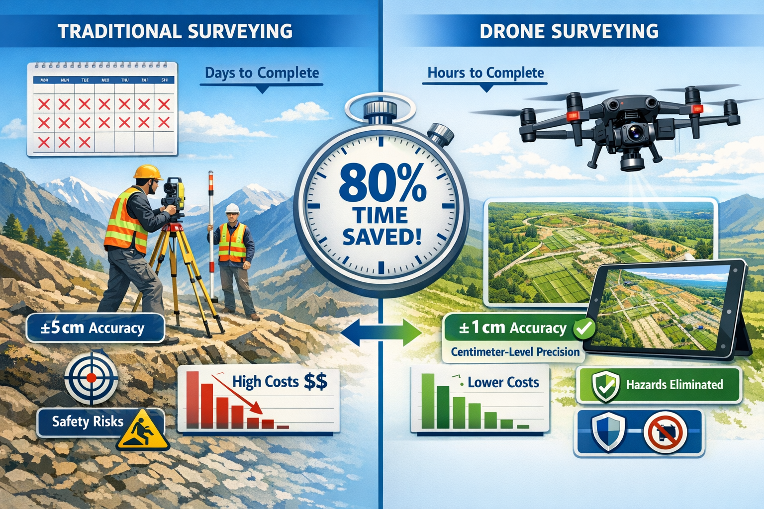
- Efficiency Revolution: Drone-enabled surveys have reduced field time by 50% for major construction projects, with some operations completing in hours what previously required days or weeks of traditional ground-based surveying.[1][2]
- Centimeter-Level Precision: Modern UAVs equipped with high-resolution cameras and LiDAR sensors deliver exceptional accuracy for topographic mapping, with results dependent on sensor quality, flight altitude, and ground control point implementation.[3]
- Regulatory Expansion: New 2026 regulations enable longer flights and BVLOS operations, allowing surveyors to map larger areas without maintaining constant visual contact with the aircraft.[5][6]
- Cost and Safety Benefits: Drone surveying significantly reduces operational costs by requiring fewer personnel and less equipment while eliminating on-site hazards associated with challenging terrain and dangerous environments.[1]
- Market Leadership: Land surveying represents the largest segment of the commercial drone market, driving technological innovation and regulatory development across the entire UAV industry.[5]
Understanding the Revolution: How Drones Transform Property Surveying
The Traditional Surveying Challenge
Traditional property surveying methods have served the industry for decades, but they come with inherent limitations. Ground-based surveying requires surveyors to physically traverse every section of a property, setting up equipment at multiple stations, taking measurements, and manually recording data. This process is:
- Time-intensive: Large properties can require weeks of fieldwork
- Labor-heavy: Multiple team members needed for efficient coverage
- Potentially hazardous: Surveyors must access difficult or dangerous terrain
- Weather-dependent: Operations frequently delayed by adverse conditions
- Costly: Extended fieldwork translates to higher project expenses
For complex topographic mapping projects, these challenges compound significantly. Properties with steep slopes, dense vegetation, water features, or hazardous conditions present additional obstacles that slow progress and increase risk.
The Drone Advantage: Speed, Safety, and Precision
Unmanned aerial vehicles fundamentally reimagine the surveying workflow. Instead of ground-based measurements, drones capture comprehensive aerial data through systematic flight patterns over the property. This approach delivers multiple transformative advantages:
Speed and Efficiency: Drones have cut field time by 50% for major construction projects since 2025, completing surveys in hours rather than the days or weeks required by traditional methods.[2] A case study from a Nevada solar farm demonstrated an 80% reduction in inspection time using drones equipped with thermal imaging capabilities.[2]
Enhanced Safety: By capturing property data remotely, drones eliminate many on-site hazards. Surveyors can remain at safe distances from challenging terrain, busy roadways, unstable structures, and other dangerous environments.[1] This safety benefit extends beyond personnel protection—it also reduces liability exposure for surveying firms.
Cost Reduction: Operational costs for drone surveying are significantly lower than traditional methods because the same work can be completed with fewer people and less equipment.[1] The democratization of drone technology means that even small surveying firms can now access capabilities that were previously available only to large organizations with substantial capital investments.
Comprehensive Data Capture: A single drone flight can capture thousands of high-resolution images and data points, creating detailed records that can be analyzed long after fieldwork concludes. This comprehensive documentation provides value beyond the immediate surveying project, serving as a baseline for future comparisons and assessments.
Key Applications in Property Surveying
Drones excel across numerous property surveying applications:
- Topographic Mapping: Creating detailed elevation models and contour maps
- Boundary Surveys: Defining property lines and easements with precision
- Volumetric Calculations: Measuring stockpiles, excavations, and earthwork quantities
- Construction Progress Monitoring: Documenting site development over time
- Infrastructure Inspections: Assessing roads, utilities, and built structures
- Environmental Assessments: Mapping vegetation, drainage patterns, and ecological features
- As-Built Documentation: Verifying completed construction against design specifications
Technology Deep Dive: Equipment and Capabilities for Accurate Topographic Mapping in 2026
Essential Drone Hardware Components
Understanding the technology behind Drones in Property Surveying: Mastering UAV Applications for Accurate Topographic Mapping in 2026 requires familiarity with key hardware components:
Platform Selection: Professional surveying drones range from compact consumer-grade models to specialized industrial platforms. The choice depends on project requirements, payload capacity needs, and flight duration demands. Multi-rotor platforms offer superior stability and hover capabilities, while fixed-wing drones provide extended flight times for large-area coverage.
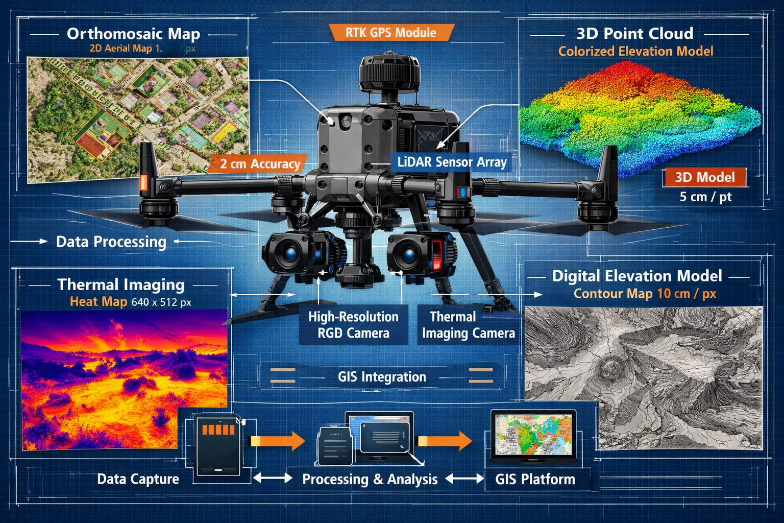
Camera Systems: High-resolution RGB cameras form the foundation of photogrammetric surveying. Modern surveying drones typically feature cameras with 20+ megapixel sensors capable of capturing images with sufficient overlap for accurate 3D reconstruction. Camera quality directly impacts the achievable ground sampling distance (GSD)—the real-world distance represented by each pixel in the imagery.
LiDAR Sensors: Light Detection and Ranging technology is "really starting to hit" the market in 2026 as a critical adoption focus for surveyors.[5] LiDAR sensors emit laser pulses and measure their return time to create precise three-dimensional point clouds. Unlike photogrammetry, LiDAR can penetrate vegetation canopy to capture ground surface elevation—a crucial capability for topographic mapping in forested areas.
RTK/PPK GPS Systems: Real-Time Kinematic (RTK) and Post-Processed Kinematic (PPK) positioning systems enable centimeter-level accuracy without extensive ground control points.[3] These systems use corrections from base stations to achieve positioning precision that meets professional surveying standards.
Thermal and Multispectral Sensors: Specialized sensors expand surveying capabilities beyond visible light. Thermal cameras detect temperature variations useful for infrastructure inspections, while multispectral sensors capture data across multiple wavelength bands for vegetation analysis and environmental assessments.
Data Output Types and Applications
Modern drone surveying produces diverse data outputs, each serving specific analytical purposes:
| Data Output | Description | Primary Applications |
|---|---|---|
| Orthomosaic Maps | Geometrically corrected aerial images stitched into a single map | Property visualization, boundary identification, feature measurement |
| Digital Elevation Models (DEM) | Raster representations of terrain elevation | Topographic analysis, drainage modeling, cut/fill calculations |
| 3D Point Clouds | Millions of individual points with X, Y, Z coordinates | Detailed surface modeling, volumetric measurements, structural analysis |
| 3D Mesh Models | Textured three-dimensional surface models | Visualization, stakeholder presentations, design integration |
| Contour Maps | Lines connecting points of equal elevation | Traditional surveying deliverables, engineering design, planning applications |
| Thermal Imagery | Temperature data visualization | Infrastructure inspections, moisture detection, energy audits |
These outputs integrate seamlessly with Geographic Information Systems (GIS), delivering "improved accuracy, reduced costs, and simplified workflows" that democratize advanced surveying capabilities.[4]
Accuracy Considerations and Quality Control
Achieving centimeter-level accuracy requires attention to multiple factors throughout the surveying workflow:[3]
Flight Planning: Systematic flight patterns with adequate image overlap (typically 70-80% forward and side overlap) ensure complete coverage and enable accurate photogrammetric reconstruction. Flight altitude directly impacts ground sampling distance—lower flights capture finer detail but require more images to cover the same area.
Ground Control Points (GCPs): Precisely surveyed reference points distributed throughout the project area enable georeferencing of drone data to real-world coordinates. While RTK/PPK systems reduce GCP requirements, strategic placement of control points remains best practice for maximum accuracy verification.
Environmental Conditions: Weather significantly impacts data quality. Strong winds affect flight stability and image sharpness, while lighting conditions influence photogrammetric processing. Overcast conditions often provide ideal lighting by eliminating harsh shadows.
Processing Parameters: Software settings during photogrammetric processing affect final accuracy. Proper camera calibration, appropriate point cloud densification settings, and correct coordinate system selection all contribute to reliable results.
Verification and Validation: Professional workflows include independent accuracy verification through checkpoints—surveyed locations not used in the processing workflow but compared against final outputs to quantify achieved accuracy.
For professionals seeking comprehensive property assessments, understanding how drone surveying complements traditional approaches like building surveys provides valuable context for integrated property evaluation strategies.
Case Studies: Real-World Efficiency Gains and ROI
Large-Scale Land Development Project
A major residential development project spanning 500 acres in the Southeast United Kingdom demonstrates the transformative impact of drone surveying. The project required detailed topographic mapping for infrastructure planning, drainage design, and earthwork calculations.
Traditional Approach Estimate:
- Field time: 3-4 weeks with a 4-person crew
- Personnel costs: £25,000-£30,000
- Equipment mobilization: £5,000
- Total estimated cost: £30,000-£35,000
- Timeline: 5-6 weeks including processing
Drone Surveying Approach:
- Field time: 2 days with a 2-person crew
- Personnel costs: £3,500
- Equipment costs: £1,200
- Total project cost: £4,700
- Timeline: 1.5 weeks including processing
Results: The drone approach delivered 86% cost savings and 75% time reduction while achieving comparable accuracy to traditional methods. The comprehensive aerial imagery also provided additional value for marketing materials and stakeholder communications—benefits not captured in the direct cost comparison.
Solar Farm Infrastructure Inspection
A Nevada solar installation covering 2,000 acres required comprehensive inspection to identify panel defects, connection issues, and maintenance needs. This case study, documented in 2024, illustrates the inspection efficiency gains achievable with thermal imaging-equipped drones.[2]
Traditional Inspection Approach:
- Manual inspection of individual panels
- Estimated time: 2-3 weeks
- Safety concerns: Heat exposure, electrical hazards
- Limited documentation capabilities
Drone Inspection Approach:
- Systematic thermal imaging flights
- Completed in: 3 days
- 80% reduction in inspection time
- Comprehensive thermal imagery database for ongoing analysis
The thermal imaging capabilities enabled identification of issues invisible to visual inspection, including failing electrical connections and underperforming panels. The efficiency gains allowed the facility to conduct more frequent inspections, shifting from annual reviews to quarterly monitoring without increasing inspection budgets.
Urban Property Boundary Survey
A complex urban property with multiple structures, mature trees, and challenging access points required precise boundary determination for a property dispute resolution. This project highlights how drones overcome access limitations while maintaining accuracy.
Challenge: Traditional surveying faced obstacles from locked buildings, privacy-sensitive areas, and dense vegetation obscuring sight lines between survey stations.
Solution: A drone equipped with RTK GPS and a high-resolution camera captured comprehensive aerial imagery in a single morning flight. LiDAR data penetrated the tree canopy to capture ground surface elevation beneath vegetation.
Outcome: The surveying team completed fieldwork in 4 hours versus an estimated 3 days for traditional methods. The aerial imagery provided clear visual documentation of property features, while the LiDAR-derived topographic data enabled precise boundary plotting despite vegetation challenges. The comprehensive documentation proved invaluable during dispute mediation, providing objective visual evidence accepted by all parties.
Construction Progress Monitoring
A commercial construction project utilized monthly drone surveys to document progress, verify contractor work, and update project stakeholders. This ongoing application demonstrates how drones add value beyond one-time surveying projects.
Implementation: Monthly flights captured orthomosaic imagery and 3D models throughout the 18-month construction timeline. Each survey required approximately 2 hours of field time plus processing.
Benefits Realized:
- Early detection of construction deviations from design specifications
- Visual progress documentation for stakeholder reporting and contractor accountability
- Volumetric verification of earthwork and material quantities for payment verification
- As-built documentation for facility management and future renovations
- Dispute prevention through objective, timestamped visual records
The project manager estimated that early detection of a single foundation deviation saved over £50,000 in potential rework costs—far exceeding the total investment in drone surveying services throughout the project.
For property owners considering renovations or improvements, understanding how comprehensive surveys inform project planning connects to broader property renovation strategies that maximize value and minimize risks.
Navigating the 2026 Regulatory Landscape
Key Regulatory Changes for Drone Surveying
The regulatory framework governing Drones in Property Surveying: Mastering UAV Applications for Accurate Topographic Mapping in 2026 is experiencing significant evolution. Understanding these changes is essential for compliant and effective operations.
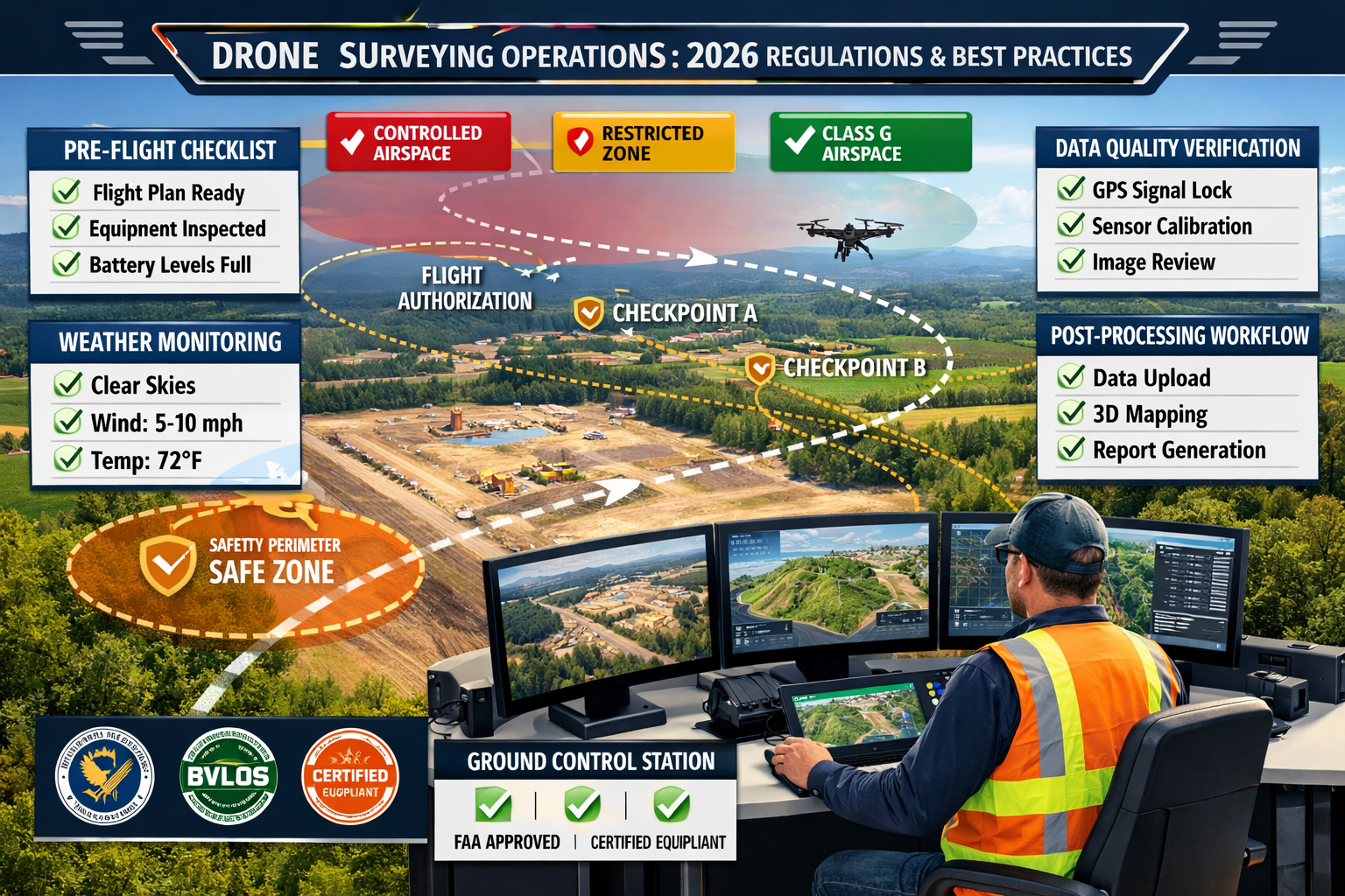
Beyond Visual Line of Sight (BVLOS) Framework: New regulations in 2026 enable longer drone flights and implement a BVLOS framework, allowing surveyors and engineers to fly drones over larger areas without maintaining constant visual contact with the aircraft.[5][6] This regulatory expansion dramatically increases the practical size of properties that can be surveyed in a single flight operation.
BVLOS operations require:
- Enhanced pilot training and certification
- Robust detect-and-avoid systems
- Comprehensive risk assessments
- Coordination with air traffic management systems
- Detailed operational procedures and emergency protocols
Foreign Drone Equipment Restrictions: A ban on foreign-made drones is being implemented, impacting equipment procurement strategies for surveying firms in 2026.[4] This regulatory change requires careful evaluation of equipment suppliers and may necessitate platform transitions for firms currently operating affected equipment.
Surveying professionals should:
- Audit current equipment to identify affected platforms
- Evaluate domestic alternatives that meet operational requirements
- Plan transition timelines to ensure continuity of service
- Budget for potential equipment replacement costs
- Stay informed on regulatory implementation details and timelines
Enhanced Operational Standards: Evolving regulations emphasize operational safety, data security, and privacy protection. Surveying firms must implement robust operational procedures addressing:
- Pre-flight safety checks and equipment verification
- Airspace authorization and coordination procedures
- Privacy considerations for residential properties
- Data security protocols for sensitive property information
- Insurance requirements and liability coverage
- Incident reporting and investigation procedures
Best Practices for Regulatory Compliance
Operator Certification: Ensure all drone pilots hold appropriate certifications for commercial operations. In the UK, this typically requires completion of the A2 Certificate of Competency (A2 CofC) for operations in the specific category, or an Operational Authorization for more complex operations. Maintain current knowledge of regulatory updates through ongoing professional development.
Operational Authorizations: Many professional surveying operations require specific operational authorizations from the Civil Aviation Authority (CAA). These authorizations may be necessary for:
- Operations beyond visual line of sight
- Flights over congested areas
- Operations near airports or controlled airspace
- Night operations
- Operations involving specific equipment or procedures
Documentation and Record-Keeping: Maintain comprehensive records of all flight operations, including:
- Pre-flight checklists and safety assessments
- Flight logs with date, time, location, and duration
- Equipment maintenance records
- Pilot training and certification documentation
- Airspace authorizations and coordination communications
- Incident reports and corrective actions
Privacy and Data Protection: Property surveying often involves capturing imagery of residential properties and private land. Implement procedures to:
- Notify property owners of planned survey operations
- Respect privacy concerns and address objections appropriately
- Secure data storage and transmission to protect sensitive information
- Comply with GDPR and data protection regulations
- Establish clear data retention and disposal policies
Insurance Coverage: Obtain appropriate insurance coverage addressing the unique risks of drone operations, including:
- Public liability coverage for third-party property damage or injury
- Equipment coverage for loss or damage to drone platforms
- Professional indemnity insurance for surveying services
- Data breach and cyber liability coverage
Working with experienced professionals who understand both traditional surveying standards and modern drone capabilities ensures comprehensive property assessments. Learn more about why property owners hire surveyors to understand the full scope of professional surveying services.
Integration Strategies: Implementing Drone Surveying in Your Practice
Equipment Selection and Investment Planning
Implementing Drones in Property Surveying: Mastering UAV Applications for Accurate Topographic Mapping in 2026 requires strategic equipment decisions aligned with your specific service offerings and client needs.
Entry-Level Implementation (£5,000-£15,000):
- Consumer-grade drone with high-quality camera
- Basic photogrammetry software subscription
- Essential accessories (batteries, storage, transport)
- Suitable for: Small property surveys, visual inspections, supplementary documentation
Professional Implementation (£15,000-£50,000):
- Professional surveying drone with RTK/PPK capabilities
- Advanced photogrammetry and processing software
- Ground control point equipment
- Comprehensive accessory package
- Suitable for: Full-service topographic surveying, construction monitoring, precision applications
Advanced Implementation (£50,000+):
- Multiple specialized platforms (photogrammetry and LiDAR)
- Enterprise software solutions with GIS integration
- Comprehensive ground control and verification equipment
- Thermal and multispectral sensors
- Suitable for: Large-scale operations, specialized applications, multi-service offerings
LiDAR Adoption Considerations: LiDAR technology is "really starting to hit" the market in 2026 as a critical focus for surveyors.[5] While LiDAR systems represent significant investment (typically £30,000-£100,000+), they enable capabilities impossible with photogrammetry alone:
- Ground surface mapping beneath vegetation canopy
- Precise elevation data in challenging lighting conditions
- Enhanced accuracy for complex terrain
- Reduced dependency on optimal weather conditions
- Differentiation in competitive markets
Software and Processing Workflows
Efficient data processing transforms raw drone imagery into actionable surveying deliverables. Modern workflows integrate multiple software tools:
Photogrammetry Processing: Software like Pix4D, Agisoft Metashape, or DroneDeploy processes overlapping images into orthomosaic maps, elevation models, and 3D point clouds. Processing parameters significantly impact accuracy and output quality—invest time in understanding optimal settings for different project types.
GIS Integration: Geographic Information Systems enable sophisticated analysis of drone-derived data. Integration with platforms like ArcGIS or QGIS delivers "improved accuracy, reduced costs, and simplified workflows" that democratize advanced capabilities.[4] GIS integration allows:
- Overlay of survey data with existing mapping layers
- Sophisticated spatial analysis and measurements
- Professional cartographic output production
- Integration with CAD systems for engineering applications
- Long-term data management and archival
Point Cloud Processing: Specialized software handles massive LiDAR point clouds, enabling classification, filtering, and analysis. Tools like CloudCompare, LP360, or specialized modules within comprehensive platforms process billions of points efficiently.
Quality Control Tools: Implement systematic quality verification through:
- Automated accuracy reporting from processing software
- Independent checkpoint verification
- Visual inspection of outputs for artifacts or errors
- Comparison with existing survey data for validation
- Client review and approval workflows
Training and Skill Development
Successful implementation requires investment in personnel development:
Pilot Training: Beyond regulatory requirements, develop operational proficiency through:
- Regular flight practice in varied conditions
- Emergency procedure rehearsals
- Equipment-specific training for new platforms
- Advanced techniques for challenging environments
Processing Expertise: Data processing skills directly impact deliverable quality and efficiency:
- Formal training in photogrammetry software
- Understanding of surveying principles and accuracy requirements
- GIS proficiency for advanced analysis and integration
- Troubleshooting skills for processing challenges
Continuous Learning: The rapid evolution of drone technology and regulations demands ongoing professional development:
- Industry conferences and workshops
- Manufacturer training programs
- Professional association resources
- Peer networking and knowledge sharing
For professionals expanding service offerings, understanding how drone surveying complements traditional approaches like structural engineering assessments provides valuable context for comprehensive property services.
Advanced Applications and Emerging Opportunities
Multispectral and Thermal Surveying
Beyond standard RGB imagery and LiDAR topographic mapping, specialized sensors unlock additional applications:
Thermal Imaging Applications:
- Building envelope inspections revealing insulation deficiencies
- Moisture detection in roofing systems
- Solar panel performance verification
- Underground utility location through thermal signatures
- Wildlife surveys and environmental monitoring
The Nevada solar farm case study demonstrated how thermal imaging achieved an 80% reduction in inspection time while identifying issues invisible to visual inspection.[2]
Multispectral Imaging Applications:
- Vegetation health assessment for agricultural properties
- Environmental impact monitoring
- Drainage and wetland mapping
- Landscape management planning
- Ecological surveys for development projects
Integration with Building Information Modeling (BIM)
Drone-derived 3D models integrate seamlessly with BIM workflows, enabling:
- As-built verification: Comparing constructed elements against design models
- Progress monitoring: Updating BIM models with actual construction status
- Clash detection: Identifying conflicts between design and site conditions
- Facility management: Creating comprehensive 3D documentation for ongoing maintenance
- Renovation planning: Accurate existing condition modeling for modification projects
This integration creates value throughout the building lifecycle, from initial design through long-term facility management.
Real Estate Marketing and Sales Acceleration
The real estate market has rapidly adopted drone media for property marketing. In Phoenix, 60% of real estate listings incorporated drone media in 2025 (per National Association of Realtors data), dramatically accelerating sales cycles and improving property visualization.[2]
Professional surveying firms can expand service offerings to include:
- Aerial photography and videography for listings
- Virtual property tours combining drone footage with ground-level imagery
- Neighborhood and amenity showcase videos
- Development site marketing materials
- Investment property documentation
This diversification creates additional revenue streams while leveraging existing drone capabilities and regulatory compliance infrastructure.
For property investors seeking comprehensive due diligence, drone surveying complements traditional approaches outlined in our guide to property investment.
Infrastructure Asset Management
Public and private infrastructure owners increasingly utilize drone surveying for ongoing asset management:
Transportation Infrastructure:
- Road condition surveys identifying pavement defects
- Bridge inspections accessing difficult-to-reach structural elements
- Railway corridor monitoring
- Airport runway and taxiway assessments
Utility Infrastructure:
- Power line inspections identifying vegetation encroachment and equipment issues
- Pipeline corridor monitoring
- Water and wastewater facility assessments
- Telecommunications tower inspections
Municipal Applications:
- Parks and recreation facility management
- Stormwater infrastructure monitoring
- Public building roof assessments
- Emergency response and disaster assessment
These ongoing monitoring applications create recurring revenue opportunities while delivering significant value to infrastructure owners through early problem detection and comprehensive documentation.
Future Trends: What's Next for Drone Surveying
Artificial Intelligence and Automated Analysis
Machine learning and AI are transforming drone data analysis:
Automated Feature Detection: AI algorithms automatically identify and classify features in drone imagery:
- Building footprints and roof outlines
- Vegetation types and health status
- Pavement defects and infrastructure issues
- Change detection between survey periods
- Anomaly identification requiring human review
Predictive Analytics: Historical drone survey data enables predictive modeling:
- Infrastructure deterioration forecasting
- Vegetation growth projection
- Erosion and environmental change prediction
- Maintenance needs anticipation
Processing Efficiency: AI-assisted processing reduces manual intervention:
- Automated quality control and error detection
- Intelligent parameter selection for optimal results
- Batch processing of similar project types
- Reduced processing time and cost
Enhanced Sensor Technology
Sensor development continues to expand drone surveying capabilities:
Miniaturization: Smaller, lighter sensors enable deployment on compact platforms while maintaining accuracy and performance. This trend improves flight efficiency and expands operational flexibility.
Multi-Sensor Integration: Single platforms carrying multiple sensors simultaneously capture diverse data types in a single flight:
- Combined RGB, thermal, and multispectral imaging
- Integrated photogrammetry and LiDAR
- Simultaneous visual and sensor data collection
Improved Resolution and Accuracy: Ongoing sensor development delivers:
- Higher resolution imagery enabling finer detail capture
- Enhanced LiDAR point density and accuracy
- Improved low-light and challenging condition performance
- Extended sensor range and coverage capabilities
Autonomous Operations and Fleet Management
Automation is reducing the manual workload for drone operations:
Automated Flight Planning: Software generates optimal flight plans considering:
- Property boundaries and coverage requirements
- Regulatory constraints and airspace restrictions
- Weather conditions and environmental factors
- Equipment capabilities and battery limitations
Autonomous Execution: Advanced platforms execute surveys with minimal pilot intervention:
- Automated takeoff, flight, and landing
- Real-time obstacle detection and avoidance
- Adaptive flight patterns responding to conditions
- Automatic return-to-home and battery management
Fleet Coordination: Large-scale operations deploy multiple drones simultaneously:
- Coordinated coverage of extensive properties
- Specialized platforms for different data types
- Reduced total survey time for large projects
- Centralized monitoring and management
These advancements position drone surveying for continued growth and market expansion. As land surveying represents the largest segment of the commercial drone market,[5] continued innovation will be driven by professional surveying needs and applications.
For property owners seeking to understand comprehensive property assessments, exploring what questions to ask during a building survey provides valuable preparation for engaging professional services.
Overcoming Common Challenges
Weather and Environmental Limitations
Weather significantly impacts drone surveying operations:
Wind Conditions: Strong winds affect:
- Flight stability and control
- Image sharpness due to platform movement
- Battery consumption and flight time
- Safety margins and operational risk
Mitigation strategies: Schedule flights during favorable conditions, utilize platforms with superior wind resistance, implement conservative wind speed limits, maintain flexible scheduling.
Lighting Conditions: Optimal lighting produces best photogrammetric results:
- Overcast conditions provide even, shadow-free illumination
- Direct sunlight creates harsh shadows complicating processing
- Low sun angles produce long shadows obscuring terrain
- Varying light during flights creates processing challenges
Mitigation strategies: Schedule flights during optimal lighting windows, utilize HDR imaging techniques, plan flight patterns minimizing shadow impact, consider multiple flights at different times.
Precipitation and Moisture: Rain, snow, and fog prevent safe operations:
- Equipment damage risk from moisture exposure
- Reduced visibility affecting safety
- Poor image quality from atmospheric conditions
- Sensor performance degradation
Mitigation strategies: Monitor weather forecasts closely, maintain flexible scheduling, protect equipment from moisture, establish clear weather minimums for operations.
Data Management and Storage
Drone surveys generate massive data volumes requiring robust management:
Storage Requirements: A single survey can produce:
- Hundreds or thousands of high-resolution images (50-200 GB)
- Massive point clouds from LiDAR (100+ GB)
- Processed outputs including orthomosaics and models (20-50 GB)
- Multiple project versions and iterations
Solutions: Implement scalable storage infrastructure, utilize cloud-based solutions for accessibility and backup, establish clear data retention policies, archive completed projects to secondary storage.
Processing Power: Photogrammetric processing demands significant computing resources:
- High-performance processors for timely results
- Substantial RAM for large datasets (32-64+ GB)
- Powerful graphics cards accelerating processing
- Fast storage systems reducing bottlenecks
Solutions: Invest in appropriate workstation hardware, utilize cloud processing services for large projects, batch process during off-hours, consider dedicated processing equipment.
Client Education and Expectation Management
Successful drone surveying requires effective client communication:
Accuracy Expectations: Clients may not understand factors affecting achievable accuracy:
- Sensor and equipment capabilities
- Environmental conditions and constraints
- Ground control point requirements
- Processing methodology impact
Solutions: Provide clear accuracy specifications before project commencement, explain factors affecting results, deliver comprehensive accuracy reports, manage expectations through education.
Deliverable Understanding: Clients may be unfamiliar with drone survey outputs:
- Orthomosaic maps versus traditional aerial photography
- Point cloud data and applications
- Digital elevation models and uses
- 3D model capabilities and limitations
Solutions: Provide sample deliverables during proposal phase, offer demonstrations of data visualization, explain practical applications of different outputs, deliver user-friendly formats.
Timeline Considerations: Weather dependency creates scheduling uncertainty:
- Flight windows dependent on favorable conditions
- Processing time requirements after data capture
- Revision and quality control procedures
Solutions: Communicate realistic timelines with weather contingencies, provide progress updates throughout projects, maintain flexible scheduling, establish clear communication protocols.
Understanding how drone surveying integrates with comprehensive property assessments connects to broader professional services like RICS building surveys that provide holistic property evaluations.
Conclusion: Embracing the Future of Property Surveying
Drones in Property Surveying: Mastering UAV Applications for Accurate Topographic Mapping in 2026 represents far more than a technological trend—it's a fundamental transformation in how surveying professionals capture, analyze, and deliver spatial data. The evidence is compelling: 50% reductions in field time, 80% improvements in inspection efficiency, centimeter-level accuracy, and significant cost savings demonstrate that drone technology has moved from experimental to essential.[1][2][3]
The regulatory landscape is evolving to support expanded operations, with BVLOS frameworks enabling larger-area coverage and new operational capabilities.[5][6] While foreign equipment restrictions create procurement challenges, they also drive innovation in domestic manufacturing and create opportunities for early adopters of compliant platforms.[4]
For surveying professionals, the question is no longer whether to adopt drone technology, but how to implement it strategically to maximize competitive advantage, operational efficiency, and client value. The democratization of advanced surveying capabilities through affordable drone platforms and sophisticated software means that firms of all sizes can access technology that delivers professional-grade results.
Actionable Next Steps
For Surveying Professionals Ready to Implement Drone Technology:
- Assess your current service offerings and identify applications where drone surveying delivers maximum value and differentiation
- Develop a phased implementation plan starting with equipment appropriate to your initial applications and scaling as capabilities develop
- Invest in comprehensive training for both flight operations and data processing to ensure quality deliverables
- Establish robust operational procedures addressing safety, regulatory compliance, quality control, and client communication
- Stay informed on regulatory developments affecting drone operations in your jurisdiction
- Network with other professionals to share knowledge, learn from experiences, and stay current on industry developments
For Property Owners and Developers Considering Drone Surveying:
- Evaluate your project requirements to determine whether drone surveying offers advantages over traditional methods
- Select experienced providers with appropriate certifications, insurance, and demonstrated expertise
- Communicate clearly about accuracy requirements, deliverable formats, and project timelines
- Understand the factors affecting cost, schedule, and achievable results
- Consider ongoing applications beyond one-time surveys, including progress monitoring and asset management
For Industry Stakeholders and Policymakers:
- Support continued regulatory development that balances operational flexibility with safety and privacy protection
- Invest in workforce development programs preparing surveyors for technology integration
- Promote standardization of data formats, accuracy specifications, and professional practices
- Encourage innovation in sensor technology, processing software, and operational methodologies
The future of property surveying is aerial, autonomous, and increasingly accessible. As land surveying represents the largest segment of the commercial drone market,[5] continued innovation will be driven by professional needs and applications. Organizations that embrace this transformation strategically—investing in appropriate technology, developing necessary skills, and implementing robust procedures—will be positioned to lead their markets and deliver exceptional value to clients.
The revolution in Drones in Property Surveying: Mastering UAV Applications for Accurate Topographic Mapping in 2026 is not coming—it's here. The only question is whether you'll lead it or follow it.
For comprehensive property services combining cutting-edge drone surveying with traditional professional expertise, explore the full range of chartered surveyor services available to support your property needs.
References
[1] Drone Surveying – https://uavcoach.com/drone-surveying/
[2] Aerial Drone Services – https://www.extremeaerialproductions.com/post/aerial-drone-services
[3] Advancing Surveying With Drone Technology – https://www.unmannedsystemstechnology.com/feature/advancing-surveying-with-drone-technology/
[4] Three Things Geospatial Professionals Should Know About The Drone Industry In 2026 – https://www.geoweeknews.com/news/three-things-geospatial-professionals-should-know-about-the-drone-industry-in-2026
[5] Watch – https://www.youtube.com/watch?v=CSTodaZb4Vc
[6] Webinar The State Of Drone Surveying A Strategic Briefing For 2026 – https://www.aerotas.com/blog/webinar-the-state-of-drone-surveying-a-strategic-briefing-for-2026