The land surveying industry has undergone a dramatic transformation. What once required weeks of fieldwork, multiple crew members, and significant equipment investments can now be accomplished in hours with a single drone operator. Drones and UAVs Revolutionizing Land Surveying: 2026 Applications for Topographic Mapping and Large-Scale Projects represents not just an incremental improvement but a fundamental shift in how professionals capture, analyze, and deliver geospatial data.
The catalyst for this revolution? A perfect storm of technological advancement and economic accessibility. LiDAR systems that cost hundreds of thousands of pounds just five years ago are now available for a fraction of that price, while delivering superior performance[1]. High-resolution photogrammetry cameras, once reserved for specialized aircraft, now fit comfortably on consumer-grade UAV platforms. Most importantly, the integration of RTK/PPK GNSS technology has elevated drone surveys from approximate visual tools to survey-grade data acquisition systems capable of centimeter-level accuracy[1].
This convergence has created unprecedented opportunities for surveyors, developers, engineers, and land managers. Projects that were previously economically unfeasible due to surveying costs are now viable. Remote locations that required extensive mobilization can be mapped quickly and safely. Large-scale infrastructure developments can be monitored continuously rather than periodically.
Key Takeaways
- 🚁 Cost reduction of 60-75%: Modern drone surveys deliver the same accuracy as traditional methods at a fraction of the cost, with single missions covering hundreds of acres in hours instead of days or weeks[1][2]
- 📊 Centimeter-level precision is now standard: RTK/PPK GNSS integration enables survey-grade accuracy that meets or exceeds traditional ground-based methods, transforming drones into core geospatial data acquisition systems[1]
- 🤖 AI automation accelerates workflows: Machine learning now handles complex analytical tasks that previously required weeks of manual processing, representing the biggest transformative event in surveying for 2026[1]
- 🔗 Seamless integration with enterprise systems: Drone data flows directly into BIM, GIS platforms, and digital twin environments, creating continuous feedback loops between real-world conditions and digital models[1]
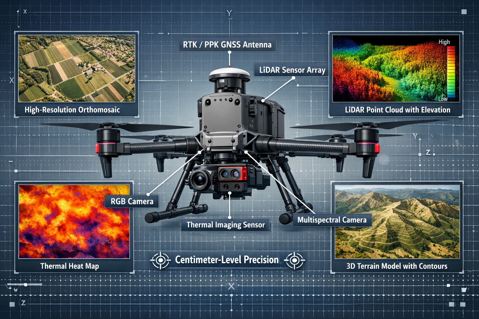
- 🌍 Multi-sensor capabilities expand applications: Modern UAVs combine RGB, LiDAR, thermal, and multispectral sensors with onboard AI for real-time validation and terrain-aware flight planning[1]
Understanding the Cost Revolution in Drone Surveying Technology
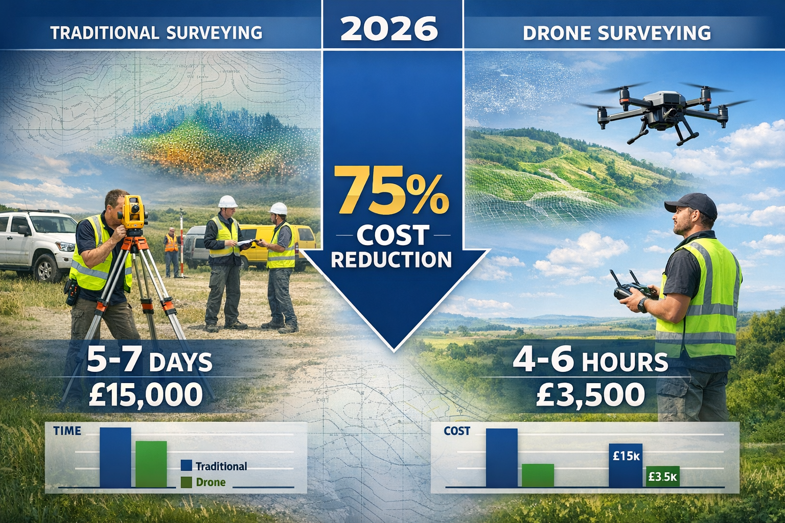
The economic transformation of drone surveying technology has been nothing short of remarkable. In 2020, a professional-grade LiDAR system suitable for topographic mapping would have required an investment of £150,000-£300,000. By 2026, comparable or superior systems are available for £30,000-£60,000—a reduction of approximately 80%[1].
Breaking Down the Cost Advantages
The financial benefits extend far beyond equipment acquisition. Operational costs have decreased significantly compared to traditional surveying methods, as drone surveys require fewer personnel and less equipment while delivering equivalent or superior results[2].
Consider a typical 100-acre topographic survey for a development project:
| Method | Duration | Personnel | Equipment Cost | Total Project Cost |
|---|---|---|---|---|
| Traditional Ground Survey | 5-7 days | 3-4 surveyors | £25,000+ | £12,000-£18,000 |
| Drone Survey (2026) | 4-6 hours | 1 operator + 1 surveyor | £40,000 (amortized) | £3,000-£5,000 |
| Savings | 85% faster | 60% fewer staff | Variable | 70-75% reduction |
These figures represent real-world scenarios based on industry data from 2026[2]. The time savings alone translate to faster project timelines, earlier decision-making, and reduced holding costs for developers.
LiDAR Technology Becomes Mainstream
LiDAR has achieved mainstream adoption with drastically reduced costs and improved sensors, becoming the standard method for topographic surveys, forestry surveys, electric powerline mapping, and mining volumetrics[1]. The technology that was once reserved for specialized applications is now accessible to mid-sized surveying firms and even individual practitioners.
Modern LiDAR systems deliver:
- Faster pulse repetition rates: Up to 900,000 points per second, compared to 200,000 in earlier systems
- Better inertial measurement unit (IMU) integration: Improved accuracy during dynamic flight conditions
- Enhanced canopy penetration: More accurate ground surface detection under dense vegetation[1]
For professionals seeking comprehensive property assessments, integrating drone surveys with traditional building survey methods creates a complete picture of both land and structures.
Photogrammetry Advances Complement LiDAR
While LiDAR captures the headlines, photogrammetry and drone-based acquisition have become mainstream rather than niche applications[3]. High-resolution RGB cameras now capture imagery at resolutions exceeding 1cm ground sampling distance (GSD), enabling detailed feature extraction and measurement.
The combination of photogrammetry and LiDAR provides complementary data:
- Photogrammetry excels at: Texture mapping, visual documentation, orthomosaic production, and visible feature identification
- LiDAR excels at: Vegetation penetration, elevation accuracy, utility corridor mapping, and volumetric calculations
Software solutions now treat drone-based acquisition as one of the pillars of modern aerial mapping rather than a parallel track, with seamless integration alongside terrestrial scans and traditional aerial photography[3].
Precision and Accuracy: How Drones and UAVs Revolutionizing Land Surveying Achieve Survey-Grade Results
The question that dominated discussions about drone surveying just three years ago—"Can it really match traditional survey accuracy?"—has been definitively answered. Centimeter-level accuracy is now standard through RTK/PPK GNSS integration on modern UAV platforms, enabling survey-grade data that meets or exceeds traditional ground-based methods[1].
RTK/PPK Technology Explained
Real-Time Kinematic (RTK) and Post-Processed Kinematic (PPK) positioning represent the technological breakthrough that elevated drone surveys to professional standards.
RTK systems receive correction signals from a base station during flight, adjusting the drone's position data in real-time. This enables:
- ✅ Horizontal accuracy: ±2-3 cm
- ✅ Vertical accuracy: ±3-5 cm
- ✅ Immediate quality verification during flight
- ✅ Reduced post-processing time
PPK systems record raw GNSS data during flight and apply corrections afterward, offering:
- ✅ Similar accuracy to RTK (±2-5 cm)
- ✅ Greater reliability in challenging signal environments
- ✅ No requirement for constant base station communication
- ✅ Flexibility to use multiple correction sources
This precision capability has transformed drones from visual tools into core geospatial data acquisition systems[1]. Surveyors can now confidently deliver CAD-ready outputs, contour maps, and elevation models that integrate directly into engineering workflows.
Reduced Dependency on Ground Control Points
Historically, achieving survey-grade accuracy required establishing numerous ground control points (GCPs) throughout the survey area—a time-consuming process that partially negated the efficiency advantages of drone surveys.
Dependency on ground control points has been substantially reduced due to RTK/PPK advancements and AI-assisted correction, particularly benefiting remote locations, linear infrastructure projects, and emergency response mapping[1].
Modern best practices in 2026 include:
- Minimal GCP deployment: 3-5 checkpoints for quality assurance rather than 15-20 for georeferencing
- Corridor mapping without GCPs: Linear infrastructure projects using PPK with virtual reference stations
- AI-assisted verification: Machine learning algorithms identify potential accuracy issues during processing
For projects requiring detailed structural analysis, combining drone topographic data with construction and condition surveys provides comprehensive documentation.
Survey-Grade Deliverables
The outputs from modern drone surveys match or exceed traditional surveying deliverables:
📋 Standard Deliverables Include:
- Orthomosaic maps: Geometrically corrected aerial imagery at 1-3cm resolution
- Digital Elevation Models (DEM): Bare earth surface models for engineering design
- Digital Surface Models (DSM): Complete surface including vegetation and structures
- Contour maps: CAD-ready topographic contours at specified intervals
- Point clouds: Classified LiDAR or photogrammetric point data
- 3D mesh models: Textured models for visualization and measurement
- Volumetric calculations: Cut-and-fill analysis, stockpile measurements
These outputs integrate directly into industry-standard software platforms including AutoCAD Civil 3D, ArcGIS, and BIM environments, allowing seamless workflow integration.
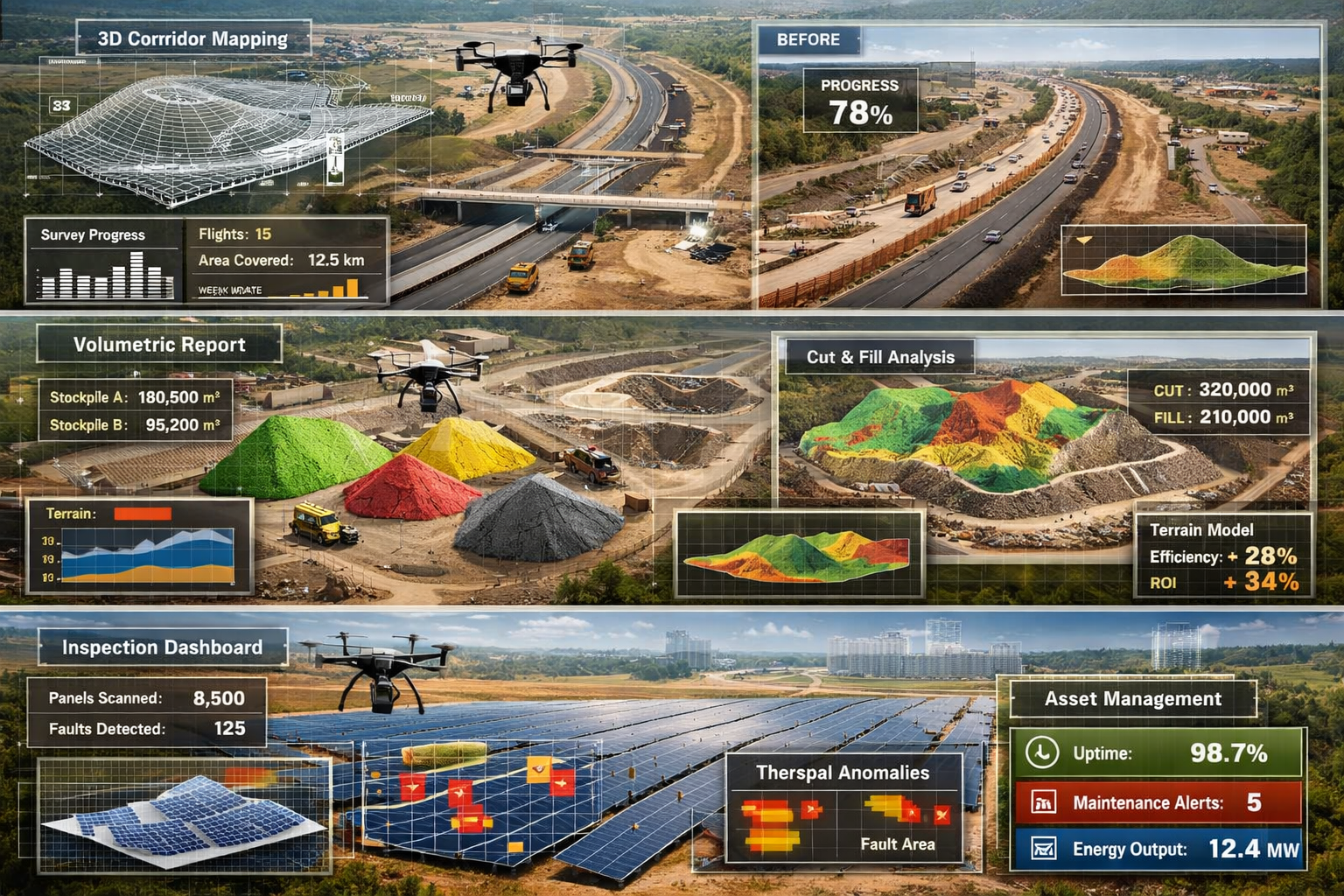
Applications Across Large-Scale Projects and Infrastructure Development
The versatility of drone surveying technology has expanded its applications far beyond traditional topographic mapping. Single UAV missions can now survey hundreds of acres in hours, compared to traditional land surveying that often requires multiple field crews and extended site access over days or weeks[1].
Construction and Development Projects
Large-scale development projects benefit tremendously from drone surveying at every phase:
Site Selection and Feasibility (Pre-Development)
- Rapid topographic assessment of multiple potential sites
- Environmental constraint identification
- Access route planning and grading analysis
- Preliminary earthwork volume estimates
Design Phase Support
- Detailed topographic surveys for engineering design
- Drainage analysis and watershed delineation
- Utility corridor identification
- Integration with funding for land acquisition assessments
Construction Monitoring
- Weekly or monthly progress documentation
- Earthwork verification and payment quantities
- Stockpile volume tracking
- As-built documentation
Post-Construction and Handover
- Final as-built surveys
- Landscaping verification
- Drainage system documentation
- Ongoing asset management baseline
Infrastructure and Linear Projects
Linear infrastructure projects—highways, railways, pipelines, and power transmission lines—present unique challenges that drone surveying addresses exceptionally well.
🛣️ Highway and Transportation Projects:
Modern transportation projects utilize drones for corridor mapping that would be prohibitively expensive using traditional methods. A 50-kilometer highway alignment can be surveyed in 2-3 days of flight operations, compared to 4-6 weeks of ground surveying[2].
The reduced GCP requirement particularly benefits these projects, as establishing control points along extensive corridors in remote or difficult terrain was historically one of the most challenging aspects of linear surveys[1].
⚡ Power Transmission and Utilities:
Drone inspections are now standard across infrastructure industries for power transmission lines, using high-resolution zoom cameras, thermal sensors, and LiDAR to identify structural issues, corrosion, heat anomalies, and alignment problems without requiring shutdowns[1].
Utility companies report 60-70% cost savings compared to traditional inspection methods, while simultaneously improving safety by eliminating the need for personnel to work at height or in hazardous environments.
Mining and Quarry Operations
The mining industry has embraced drone surveying technology more rapidly than perhaps any other sector, driven by the need for frequent volumetric measurements and safety considerations.
Typical Mining Applications:
- Stockpile volumetrics: Monthly or weekly volume calculations for inventory management
- Pit progression monitoring: Comparing actual excavation against mine plans
- Haul road condition assessment: Identifying maintenance requirements
- Rehabilitation monitoring: Documenting reclamation progress
- Safety inspections: Identifying highwall instabilities and hazardous conditions
A single drone survey can measure dozens of stockpiles in hours, a task that would require days of ground surveying and expose personnel to mobile equipment hazards. The accuracy of volumetric calculations from drone surveys typically falls within 1-2% of ground-based measurements, well within acceptable tolerances for inventory management[2].
Environmental and Agricultural Monitoring
Environmental and agricultural applications have expanded significantly, with multispectral and hyperspectral drones used for crop health monitoring, soil analysis, water resource mapping, and environmental impact assessments[1].
🌱 Agricultural Applications:
- Crop health monitoring using NDVI and other vegetation indices
- Irrigation system evaluation through thermal imaging
- Drainage pattern analysis
- Yield prediction modeling
- Precision agriculture planning
🌿 Environmental Assessment:
- Wetland delineation and monitoring
- Forest inventory and carbon storage estimation
- Erosion and sedimentation tracking
- Wildlife habitat mapping
- Environmental compliance documentation
Researchers are investigating LiDAR-based drone surveys to create accurate estimates of carbon storage in forest sections for emissions monitoring, contributing to climate change mitigation efforts[2].
The AI Revolution: Automation and Intelligence in Drone Surveying Workflows
Perhaps the most transformative development in 2026 is not the hardware itself, but the intelligence behind it. AI and machine learning are automating complex analytical workflows that previously required professional surveyors and mappers to spend days or weeks on manual processing, representing what industry sources identify as the "biggest transformative event" of 2026[1].
Automated Data Processing and Feature Extraction
Traditional photogrammetric processing required significant manual intervention: identifying tie points, removing erroneous matches, classifying point clouds, and extracting features. Modern AI-driven workflows automate these tasks with remarkable accuracy.
AI-Powered Processing Capabilities:
- 🤖 Automatic tie point generation: Machine learning identifies optimal matching points across images
- 🤖 Intelligent point cloud classification: Automated separation of ground, vegetation, buildings, and infrastructure
- 🤖 Feature extraction: Automatic identification of roads, buildings, utilities, and terrain features
- 🤖 Quality control: AI-assisted detection of processing errors and data gaps
- 🤖 Change detection: Automated comparison of multi-temporal datasets
The time savings are substantial. A complex urban survey that required 40-60 hours of manual processing in 2023 can now be processed in 8-12 hours with minimal human intervention, with comparable or superior accuracy[1].
Real-Time Mission Planning and Adaptive Flight
Modern drone systems incorporate onboard AI for terrain-aware flight planning and real-time mission adaptation. This represents a significant advancement over fixed flight plans that couldn't respond to changing conditions.
Intelligent Flight Capabilities Include:
- Terrain-following algorithms: Automatically adjusting altitude to maintain consistent ground sampling distance over varying topography
- Obstacle avoidance: Real-time detection and avoidance of unexpected obstacles
- Adaptive coverage: Identifying data gaps during flight and automatically filling them
- Battery optimization: Calculating optimal flight paths to maximize coverage per battery
- Weather response: Adjusting flight parameters based on wind conditions and lighting
These capabilities not only improve data quality but also enhance safety and operational efficiency. For professionals conducting comprehensive property assessments, understanding what is a level 3 building survey helps contextualize how drone data complements traditional inspection methods.
Integration with Digital Twins and BIM
The true power of drone surveying emerges when data flows seamlessly into enterprise systems. Drone data now integrates directly into enterprise systems including Building Information Modeling (BIM), GIS platforms, asset management systems, and digital twin environments, creating continuous feedback loops between real-world conditions and digital models[1].
Digital Twin Integration Benefits:
- Continuous monitoring: Regular drone surveys update digital twins with current conditions
- Deviation detection: Automated comparison of as-built conditions against design models
- Predictive maintenance: Identifying developing issues before they become critical
- Lifecycle management: Documenting asset conditions throughout operational life
- Stakeholder visualization: Providing intuitive 3D models for non-technical decision-makers
This integration transforms drone surveying from a periodic data collection exercise into a continuous monitoring and management system. Infrastructure owners can track asset conditions, verify maintenance activities, and plan interventions based on current, accurate data rather than assumptions or outdated surveys.
Multi-Sensor Integration: Expanding Capabilities Beyond RGB Imaging
The evolution from simple aerial photography to comprehensive multi-sensor data acquisition represents another dimension of how Drones and UAVs Revolutionizing Land Surveying: 2026 Applications for Topographic Mapping and Large-Scale Projects extends beyond traditional capabilities.
The Multi-Sensor Advantage
Multi-sensor integration is now standard, with high-resolution RGB, LiDAR, multispectral, and thermal sensors combined with onboard AI for real-time data validation and automated terrain-aware flight planning[1].
This integration enables surveyors to capture complementary datasets in a single mission:
| Sensor Type | Primary Applications | Key Advantages |
|---|---|---|
| RGB (Visual) | Orthomosaics, visual documentation, photogrammetry | High resolution, texture detail, stakeholder communication |
| LiDAR | Topographic mapping, vegetation penetration, utilities | Canopy penetration, elevation accuracy, works in low light |
| Thermal | Building inspections, solar panel assessment, water detection | Identifies temperature anomalies, moisture detection, energy audits |
| Multispectral | Agriculture, vegetation health, environmental monitoring | Crop health indices, species identification, stress detection |
| Hyperspectral | Mineral exploration, detailed vegetation analysis | Detailed spectral signatures, material identification |
Practical Applications of Multi-Sensor Surveys
The combination of multiple sensors in single missions creates new possibilities:
Urban Development Projects:
- RGB for visual documentation and stakeholder presentations
- LiDAR for accurate topographic mapping under tree canopy
- Thermal for identifying drainage issues and moisture problems
- Integration with premium drone surveys for comprehensive property assessment
Infrastructure Inspection:
- RGB zoom cameras for detailed structural assessment
- Thermal imaging for electrical component inspection
- LiDAR for precise dimensional measurement and alignment verification
- Multispectral for vegetation encroachment monitoring
Environmental Assessment:
- RGB for habitat visualization
- LiDAR for detailed terrain and vegetation structure
- Multispectral for species identification and health monitoring
- Thermal for water body delineation and thermal pollution detection
Data Fusion and Comprehensive Analysis
The real power emerges when data from multiple sensors is fused into comprehensive analytical products. Modern processing software automatically co-registers data from different sensors, enabling:
- Overlaying thermal data on visual imagery to identify specific problem areas
- Combining LiDAR elevation data with multispectral indices for precision agriculture
- Integrating RGB texture with LiDAR geometry for realistic 3D models
- Correlating thermal signatures with structural features for targeted inspections
This multi-dimensional approach provides insights impossible to obtain from any single sensor, enabling more informed decision-making and comprehensive understanding of complex sites.
Regulatory Compliance and Professional Standards in 2026
As drone surveying has matured from emerging technology to industry standard, regulatory frameworks and professional standards have evolved to ensure safety, quality, and accountability.
Current Regulatory Environment
In the UK, drone operations for commercial surveying fall under Civil Aviation Authority (CAA) regulations. By 2026, the regulatory environment has stabilized around several key requirements:
Operational Requirements:
- ✈️ Operator certification: Commercial operators must hold appropriate permissions or operate under the new streamlined authorization system
- ✈️ Pilot competency: Remote pilots must demonstrate competency through recognized training and assessment
- ✈️ Insurance coverage: Minimum liability insurance requirements for commercial operations
- ✈️ Operational limitations: Compliance with airspace restrictions, altitude limits, and visual line-of-sight requirements
- ✈️ Privacy considerations: Adherence to GDPR and privacy regulations when capturing imagery
Professional Standards and Accreditation
Professional surveying bodies have established standards specifically for drone-based surveys:
RICS Standards for Drone Surveying:
The Royal Institution of Chartered Surveyors (RICS) has developed guidance on drone surveying that addresses:
- Minimum accuracy requirements for different survey types
- Quality assurance and quality control procedures
- Competency requirements for surveyors utilizing drone data
- Deliverable specifications and metadata requirements
- Professional indemnity insurance considerations
These standards ensure that drone surveys meet the same professional standards as traditional surveying methods, providing confidence to clients and regulatory authorities.
Best Practices for Quality Assurance
Professional surveyors implementing drone technology in 2026 follow rigorous quality assurance protocols:
📋 Pre-Flight Planning:
- Site risk assessment and flight safety planning
- Mission planning with appropriate overlap and resolution
- GCP planning and establishment (where required)
- Weather monitoring and flight window optimization
📋 Data Acquisition:
- Pre-flight system calibration and verification
- Real-time data quality monitoring during flight
- Redundant data capture for critical areas
- Comprehensive flight logs and metadata
📋 Processing and Validation:
- Standardized processing workflows with documented parameters
- Independent checkpoint verification
- Comparison with existing survey data where available
- Peer review of deliverables before client release
These practices ensure consistency, accuracy, and professional accountability, maintaining the integrity of survey data regardless of acquisition method.
Case Studies: Real-World Efficiency Gains and ROI
The theoretical advantages of drone surveying translate into substantial real-world benefits. These case studies demonstrate the efficiency gains and return on investment achieved across different project types.
Case Study 1: Large-Scale Residential Development (250 Acres)
Project Overview:
A major residential development in the Southeast required comprehensive topographic surveying for master planning and infrastructure design.
Traditional Approach (Estimated):
- Duration: 3-4 weeks of field surveys
- Personnel: 4-person survey crew
- Estimated cost: £45,000-£55,000
- GCP establishment: 25-30 control points
- Processing and deliverable preparation: 2-3 weeks
Drone Survey Approach (Actual 2026):
- Duration: 3 days of flight operations (weather-dependent)
- Personnel: 1 drone operator, 1 surveyor for QC
- Actual cost: £12,000
- GCP establishment: 5 checkpoints (RTK-enabled drone)
- Processing and deliverables: 5 days
Results:
- ✅ Cost savings: 73% reduction (£33,000-£43,000 saved)
- ✅ Time savings: 75% faster completion
- ✅ Additional benefits: Monthly progress monitoring throughout construction at minimal additional cost
- ✅ Accuracy: ±3cm horizontal, ±5cm vertical—exceeding project requirements
The developer used the cost savings to commission additional specialized surveys and environmental assessments, improving overall project planning without exceeding the original survey budget.
Case Study 2: Highway Corridor Mapping (35 Kilometers)
Project Overview:
Transportation authority required detailed corridor mapping for highway improvement project, including topographic survey, drainage assessment, and utility identification.
Traditional Approach (Estimated):
- Duration: 6-8 weeks of field surveys
- Personnel: Multiple survey crews working simultaneously
- Estimated cost: £120,000-£150,000
- Traffic management: Significant costs and disruption
- Safety concerns: Personnel working adjacent to live traffic
Drone Survey Approach (Actual 2026):
- Duration: 5 days of flight operations
- Personnel: 2 drone operators working alternating sections
- Actual cost: £38,000
- Traffic management: Minimal—no lane closures required
- Safety: Zero personnel exposure to traffic
Results:
- ✅ Cost savings: 68-74% reduction
- ✅ Safety improvement: Eliminated traffic exposure for survey personnel
- ✅ Public benefit: No traffic disruption during data collection
- ✅ Data richness: Comprehensive corridor documentation including vegetation encroachment, drainage conditions, and pavement assessment
The transportation authority now conducts annual corridor surveys to monitor conditions and prioritize maintenance, something economically unfeasible with traditional methods.
Case Study 3: Quarry Volumetric Monitoring
Project Overview:
Aggregate quarry required monthly stockpile volume measurements for inventory management and customer billing.
Traditional Approach (Previous Practice):
- Duration: 2 days per month (12 stockpiles)
- Personnel: 2-person survey crew
- Monthly cost: £3,500
- Annual cost: £42,000
- Safety: Personnel working around mobile equipment
Drone Survey Approach (Implemented 2025):
- Duration: 2 hours per month
- Personnel: 1 drone operator
- Monthly cost: £800
- Annual cost: £9,600
- Safety: No personnel exposure to equipment hazards
Results:
- ✅ Annual savings: £32,400 (77% reduction)
- ✅ Increased frequency: Now conducting weekly measurements at same annual cost as previous monthly surveys
- ✅ Improved inventory management: Real-time stock levels enable better customer service
- ✅ Safety: Eliminated mobile equipment interaction hazards
The quarry operator invested savings in additional drone applications including slope stability monitoring and rehabilitation documentation, expanding the value beyond simple cost reduction.
Future Developments: What's Next for Drone Surveying Technology
While 2026 represents a mature stage for drone surveying technology, ongoing developments promise continued advancement and new capabilities.
Emerging Technologies on the Horizon
Enhanced Autonomy and Beyond Visual Line of Sight (BVLOS):
Regulatory frameworks are gradually enabling BVLOS operations, which will transform large-area surveying. Current regulations require visual line of sight, limiting practical survey areas to approximately 100-150 acres per flight. BVLOS authorization will enable:
- Corridor surveys of 50+ kilometers in single missions
- Fully autonomous repeat surveys without operator presence
- Remote area mapping without mobilization costs
- Emergency response mapping over extensive areas
Improved Sensor Technology:
Sensor development continues to advance:
- Higher resolution LiDAR: Next-generation systems achieving 1-2 million points per second
- Improved multispectral sensors: Expanded spectral bands for more detailed analysis
- Miniaturized hyperspectral sensors: Previously aircraft-only technology becoming UAV-compatible
- Quantum sensors: Emerging technology for magnetic and gravitational surveying applications
AI and Machine Learning Advancement:
The AI revolution in surveying is still in early stages:
- Predictive analytics: AI predicting infrastructure deterioration from survey data
- Automated design: AI generating preliminary designs directly from survey data
- Anomaly detection: Identifying unusual conditions requiring investigation
- Natural language interfaces: Describing survey requirements in plain language rather than technical parameters
Integration with Emerging Technologies
Drone surveying will increasingly integrate with other emerging technologies:
5G Connectivity:
High-bandwidth, low-latency 5G networks will enable real-time data streaming, allowing clients to view survey data as it's being captured and provide immediate feedback on coverage requirements.
Edge Computing:
Onboard processing capabilities will enable preliminary data products to be generated during flight, with refined products delivered within hours rather than days.
Blockchain for Data Integrity:
Blockchain technology may provide tamper-proof verification of survey data provenance and processing history, important for legal and regulatory applications.
Augmented Reality Visualization:
Survey data will be visualized in augmented reality, allowing stakeholders to view proposed designs overlaid on actual site conditions during site visits.
Sustainability and Environmental Benefits
The environmental advantages of drone surveying extend beyond reduced vehicle emissions from smaller field crews:
- Reduced site disturbance: Minimal ground access requirements preserve vegetation and soil
- Lower carbon footprint: Significantly reduced fuel consumption compared to traditional methods
- Enabling environmental monitoring: Cost-effective regular monitoring supports conservation efforts
- Supporting sustainable development: Detailed environmental data enables better-informed development decisions
For organizations focused on sustainability, integrating drone surveys with community housing projects and sustainability initiatives demonstrates environmental commitment.
Selecting the Right Drone Surveying Solution for Your Project
With the proliferation of drone surveying options in 2026, selecting the appropriate approach for specific project requirements requires careful consideration.
Key Decision Factors
Project Scale and Complexity:
- Small sites (<10 acres): Consumer-grade drones with RTK may suffice
- Medium sites (10-200 acres): Professional photogrammetry systems recommended
- Large sites (>200 acres): LiDAR-equipped systems provide efficiency advantages
- Linear projects: PPK systems reduce GCP requirements
- Complex terrain: LiDAR essential for vegetation penetration
Accuracy Requirements:
Different applications require different accuracy levels:
| Application | Typical Accuracy Requirement | Recommended Technology |
|---|---|---|
| Preliminary site assessment | ±10-20cm | Standard photogrammetry |
| Engineering design | ±3-5cm | RTK/PPK photogrammetry or LiDAR |
| Construction verification | ±2-3cm | RTK LiDAR |
| Volumetric measurement | ±1-2% volume | LiDAR or dense photogrammetry |
| Visual documentation | N/A (qualitative) | High-resolution RGB |
Budget Considerations:
While drone surveys are generally more economical than traditional methods, costs vary:
- In-house capability: Initial equipment investment £30,000-£80,000, plus training and software
- Outsourced surveys: £800-£5,000 per project depending on size and complexity
- Hybrid approach: Own basic equipment for routine work, outsource complex projects
Timeline and Urgency:
Drone surveys offer rapid turnaround, but processing time varies:
- Standard photogrammetry: 3-5 days processing for typical projects
- LiDAR surveys: 5-7 days processing for classified deliverables
- Rush processing: 24-48 hours available at premium pricing
- Progressive delivery: Preliminary products within 24 hours, refined products following
In-House vs. Outsourced Drone Surveying
Organizations must decide whether to develop in-house capability or outsource to specialists:
In-House Advantages:
- ✅ Immediate availability for urgent requirements
- ✅ Proprietary data security
- ✅ Lower marginal cost for frequent surveys
- ✅ Direct control over quality and specifications
In-House Challenges:
- ❌ Significant capital investment
- ❌ Training and competency maintenance
- ❌ Regulatory compliance responsibility
- ❌ Equipment maintenance and updates
- ❌ Underutilization risk for occasional users
Outsourced Advantages:
- ✅ No capital investment required
- ✅ Access to latest technology without ownership
- ✅ Professional expertise and quality assurance
- ✅ Regulatory compliance handled by provider
- ✅ Predictable project costs
Outsourced Challenges:
- ❌ Scheduling dependent on provider availability
- ❌ Higher per-project costs for frequent users
- ❌ Data security considerations
- ❌ Less direct control over specifications
Many organizations adopt a hybrid approach: maintaining basic capability for routine monitoring while outsourcing complex or specialized surveys to experts like those offering premium drone surveys.
Overcoming Common Challenges and Limitations
Despite the remarkable capabilities of modern drone surveying, certain challenges and limitations remain. Understanding these helps set realistic expectations and plan appropriate mitigation strategies.
Weather Dependency
Drone surveys require suitable weather conditions:
Limiting Factors:
- ☁️ Wind: Most survey drones operate safely in winds up to 25-30 mph; higher winds compromise stability and data quality
- 🌧️ Precipitation: Rain prevents flight operations and damages equipment
- 🌫️ Visibility: Low cloud, fog, or haze reduces data quality and may prevent safe operations
- ❄️ Temperature: Extreme cold reduces battery performance; extreme heat affects sensor performance
Mitigation Strategies:
- Flexible scheduling with weather contingency days
- Seasonal planning for optimal conditions
- Regional considerations (coastal wind, winter limitations)
- Backup plans for time-critical projects
Regulatory and Airspace Restrictions
Certain locations present regulatory challenges:
Restricted Areas:
- Airports and controlled airspace (authorization required)
- Urban areas with privacy considerations
- Military installations and security-sensitive sites
- National parks and protected areas (special permissions)
Mitigation Strategies:
- Early airspace research and authorization applications
- Coordination with air traffic control where required
- Alternative survey methods for permanently restricted areas
- Professional operators experienced in authorization processes
Technical Limitations
Understanding technical constraints ensures appropriate application:
Coverage and Resolution Trade-offs:
- Higher resolution requires lower flight altitude and more images, increasing flight time
- Large areas may require multiple flights and battery changes
- Processing time and storage requirements increase with data volume
Accuracy Constraints:
- Vertical accuracy typically 1.5-2× horizontal accuracy
- Accuracy degrades in areas with poor GNSS coverage (urban canyons, dense forests)
- Texture-poor surfaces (water, uniform pavement) challenge photogrammetric processing
Vegetation and Canopy:
- Photogrammetry cannot penetrate vegetation to measure ground surface
- LiDAR penetration varies with canopy density (70-90% penetration typical)
- Leaf-off conditions improve ground surface detection in deciduous forests
Data Management and Processing Requirements
The data volumes generated by drone surveys present management challenges:
Storage Requirements:
- Typical 100-acre survey: 500-1,000 images, 50-100 GB raw data
- LiDAR surveys: 200-500 GB per project
- Processed products and archives: 100-200 GB per project
Processing Demands:
- High-performance computers required for efficient processing
- Processing times: 4-12 hours for photogrammetry, 8-24 hours for LiDAR
- Software licensing costs: £2,000-£10,000 annually for professional packages
Solutions:
- Cloud processing services for occasional users
- Dedicated processing workstations for frequent users
- Systematic data archival and management protocols
- Selective retention of deliverables vs. raw data
Understanding these challenges allows realistic planning and appropriate allocation of resources to ensure successful project outcomes.
Training and Competency Development for Drone Surveying
As drone surveying becomes mainstream, developing appropriate competencies becomes essential for surveying professionals.
Required Skill Sets
Effective drone surveying requires a combination of traditional surveying knowledge and new technical skills:
Traditional Surveying Fundamentals:
- Coordinate systems and datum understanding
- Accuracy and precision concepts
- Survey control and quality assurance
- Deliverable specifications and standards
Drone-Specific Technical Skills:
- UAV flight operations and safety
- Mission planning and flight parameter optimization
- Sensor selection and configuration
- GNSS positioning (RTK/PPK) understanding
Data Processing Competencies:
- Photogrammetric processing workflows
- LiDAR data processing and classification
- Point cloud manipulation and analysis
- CAD and GIS software proficiency
Regulatory and Safety Knowledge:
- Aviation regulations and airspace restrictions
- Risk assessment and safety management
- Privacy and data protection compliance
- Insurance and liability considerations
Training Pathways
Multiple training routes exist for developing drone surveying competency:
Formal Education:
- University programs increasingly include UAV surveying modules
- Specialized postgraduate courses in geospatial technology
- Professional development courses from surveying institutions
Commercial Training Providers:
- CAA-approved pilot training for regulatory compliance (2-5 days)
- Manufacturer-specific equipment training (1-3 days)
- Software processing courses (2-5 days)
- Integrated drone surveying courses (5-10 days)
Self-Directed Learning:
- Online tutorials and courses
- Software vendor training resources
- Professional forums and user groups
- Practical experience with entry-level equipment
Professional Certification:
- RICS certification pathways for drone surveying
- Manufacturer certifications (DJI, Leica, etc.)
- Software certifications (Pix4D, Agisoft, etc.)
Continuous Professional Development
Technology evolution requires ongoing learning:
- Annual software updates with new capabilities
- Emerging sensor technologies and applications
- Regulatory changes and compliance requirements
- Industry best practices and standards development
Professional surveyors should allocate 5-10 days annually for training and professional development in drone surveying technology to maintain current competency.
Economic Impact and Industry Transformation
The adoption of drone surveying technology has fundamentally transformed the economics of the surveying industry and created new business models.
Market Growth and Adoption Rates
The drone surveying market has experienced remarkable growth:
- Global market size (2026): Estimated £4.2 billion, up from £1.8 billion in 2022
- UK market penetration: Approximately 65% of surveying firms now utilize drone technology
- Project adoption: Drones used in 40-50% of topographic surveys in 2026, up from 15% in 2022
This growth reflects both technology maturation and economic advantages that make drone surveys the logical choice for many applications.
Impact on Traditional Surveying Businesses
The rise of drone surveying has required traditional surveying firms to adapt:
Successful Adaptation Strategies:
- ✅ Investing in drone capability as complementary to traditional methods
- ✅ Developing hybrid workflows combining drone and traditional techniques
- ✅ Specializing in complex projects requiring multi-method approaches
- ✅ Focusing on data analysis and interpretation rather than just acquisition
Challenges for Traditional Firms:
- ❌ Reduced demand for traditional topographic surveys
- ❌ Price pressure from drone-enabled competitors
- ❌ Need for capital investment and training
- ❌ Competition from new drone-specialist entrants
The most successful firms have embraced drone technology as an enhancement rather than viewing it as a threat, offering clients the most appropriate method for each project.
New Business Models and Opportunities
Drone surveying has enabled new service offerings and business models:
Subscription-Based Monitoring:
Organizations now offer monthly or quarterly monitoring services for construction sites, infrastructure assets, or environmental sites at fixed subscription fees, enabled by the low marginal cost of drone surveys.
Rapid Response Services:
Emergency response organizations and insurance companies utilize rapid-deployment drone surveys for disaster assessment, providing services impossible with traditional methods.
Data-as-a-Service:
Some providers offer access to regularly updated drone survey databases covering large regions, selling access to current data rather than conducting individual surveys.
Integrated Digital Twin Services:
Combining regular drone surveys with digital twin platforms creates ongoing monitoring and management services rather than one-time survey deliverables.
These new models create value beyond traditional survey deliverables, positioning surveying firms as ongoing information providers rather than periodic service providers.
Conclusion: Embracing the Drone Revolution in Land Surveying
The transformation of land surveying through Drones and UAVs Revolutionizing Land Surveying: 2026 Applications for Topographic Mapping and Large-Scale Projects represents one of the most significant technological shifts in the profession's history. The convergence of affordable LiDAR technology, centimeter-level GNSS accuracy, AI-powered processing, and multi-sensor integration has created capabilities that seemed impossible just a decade ago.
The benefits are clear and compelling:
- Economic advantages: 60-75% cost reductions compared to traditional methods
- Efficiency gains: Projects completed in hours instead of weeks
- Safety improvements: Reduced personnel exposure to hazardous environments
- Data richness: Comprehensive multi-sensor datasets enabling better decisions
- Accessibility: Previously uneconomical projects now viable
Yet the technology's value extends beyond simple cost and time savings. Drone surveying enables continuous monitoring rather than periodic snapshots, comprehensive documentation rather than selective sampling, and informed decision-making based on current, accurate data rather than assumptions or outdated information.
Actionable Next Steps
For organizations and professionals seeking to leverage drone surveying technology:
For Surveying Professionals:
- Assess current capabilities and gaps: Evaluate whether in-house drone capability aligns with your project portfolio and client needs
- Invest in training and certification: Develop competencies through formal training and hands-on experience
- Start with pilot projects: Implement drone surveys on suitable projects to build experience and demonstrate value
- Develop quality assurance protocols: Establish rigorous QA/QC procedures to ensure professional standards
- Stay current with developments: Allocate time for ongoing professional development as technology evolves
For Project Owners and Developers:
- Specify drone surveys for appropriate projects: Include drone surveying in project specifications where it offers advantages
- Engage experienced providers: Select drone survey providers with demonstrated competency and professional credentials like premium drone surveys
- Integrate with project workflows: Ensure drone survey deliverables integrate with your design and management systems
- Consider ongoing monitoring: Evaluate subscription-based monitoring services for long-term projects
- Leverage data for multiple purposes: Maximize value by using survey data for documentation, stakeholder communication, and marketing
For Infrastructure Owners and Managers:
- Develop asset monitoring strategies: Implement regular drone surveys as part of asset management programs
- Integrate with digital twins: Connect drone survey data to digital twin platforms for comprehensive asset intelligence
- Establish baseline documentation: Conduct comprehensive drone surveys to establish current condition baselines
- Plan for continuous improvement: Use drone data to identify trends and optimize maintenance strategies
- Quantify ROI: Track cost savings and benefits to justify ongoing investment
The Future is Now
The question is no longer whether drone surveying will become mainstream—it already has. The question is how quickly organizations will adapt to leverage its capabilities and how effectively they will integrate this technology into comprehensive geospatial workflows.
Drones and UAVs Revolutionizing Land Surveying: 2026 Applications for Topographic Mapping and Large-Scale Projects is not a future vision—it's current reality. The technology is mature, the economic case is proven, and the professional standards are established. Organizations that embrace this revolution position themselves for success in an increasingly competitive and technologically sophisticated industry.
The transformation of land surveying through drone technology demonstrates how innovation, when combined with professional expertise and rigorous standards, creates value far exceeding simple automation. It's a transformation that benefits professionals, clients, and ultimately society through more efficient infrastructure development, better environmental stewardship, and safer working conditions.
The revolution is here. The question is: are you ready to be part of it?
References
[1] How Drones Are Transforming Surveying Mapping And Inspection In 2026 – https://www.uavsphere.com/post/how-drones-are-transforming-surveying-mapping-and-inspection-in-2026
[2] Drone Surveying – https://uavcoach.com/drone-surveying/
[3] Drones Transformed Photogrammetry Geo Week 2026 – https://www.commercialuavnews.com/drones-transformed-photogrammetry-geo-week-2026
[4] Revolutionizing Land Surveying The Rise Of Drone Technology And Uav Applications In 2026 – https://nottinghillsurveyors.com/blog/revolutionizing-land-surveying-the-rise-of-drone-technology-and-uav-applications-in-2026
[5] The Ultimate Guide To Uav Applications In 2026 Transforming Industries With Drones – https://www.uavmodel.com/blogs/news/the-ultimate-guide-to-uav-applications-in-2026-transforming-industries-with-drones
[6] Watch – https://www.youtube.com/watch?v=CSTodaZb4Vc
[7] Land Surveying – https://enterprise.dji.com/surveying/land-surveying