{"cover":"Professional landscape format (1536×1024) hero image with bold text overlay: 'Digital Twins, Laser Scanning & Reality Capture: When 3D Data Pays Off for Building Surveyors' in extra large 70pt white bold sans-serif font with dark semi-transparent overlay panel, centered upper third composition. Background shows a dramatic split-scene: left half features a historic stone Georgian building facade, right half shows a glowing cyan-blue 3D point cloud wireframe of the same building. Color palette: deep navy, electric cyan, white. High contrast, magazine cover editorial quality, professional architectural photography style.","content":["Wide-angle editorial photograph showing a building surveyor in a hard hat and hi-vis vest operating a tripod-mounted terrestrial laser scanner inside a Victorian heritage building with ornate plasterwork ceilings. The scanner emits visible green laser lines across the interior. A laptop screen in the foreground displays a dense colorized point cloud model of the same space. Warm ambient light contrasts with cool blue scanner glow. Landscape format 1536×1024, photorealistic, professional documentary photography style, detailed architectural textures visible.","Infographic-style illustration showing three distinct building types side by side: a heritage listed church, a modern high-rise residential tower, and a commercial building with complex M&E systems. Each building is shown with a semi-transparent digital twin overlay in glowing cyan lines. Data accuracy callout labels show figures like plus or minus 2mm and 24-72 hour delivery. Color scheme: dark charcoal background, cyan and white accent lines, bold sans-serif labels. Landscape 1536×1024, clean technical diagram aesthetic, high contrast professional infographic.","Overhead bird's-eye view of a construction project management workspace: a large monitor displays a BIM digital twin model of a multi-storey building with colour-coded mechanical and electrical systems highlighted. Surrounding the monitor are printed survey reports, a tablet showing Autodesk interface, and a hard hat. A second screen shows cost comparison bar charts. Professional office environment, warm desk lighting, shallow depth of field. Landscape 1536×1024, editorial quality, corporate photography style, technology and surveying theme."]
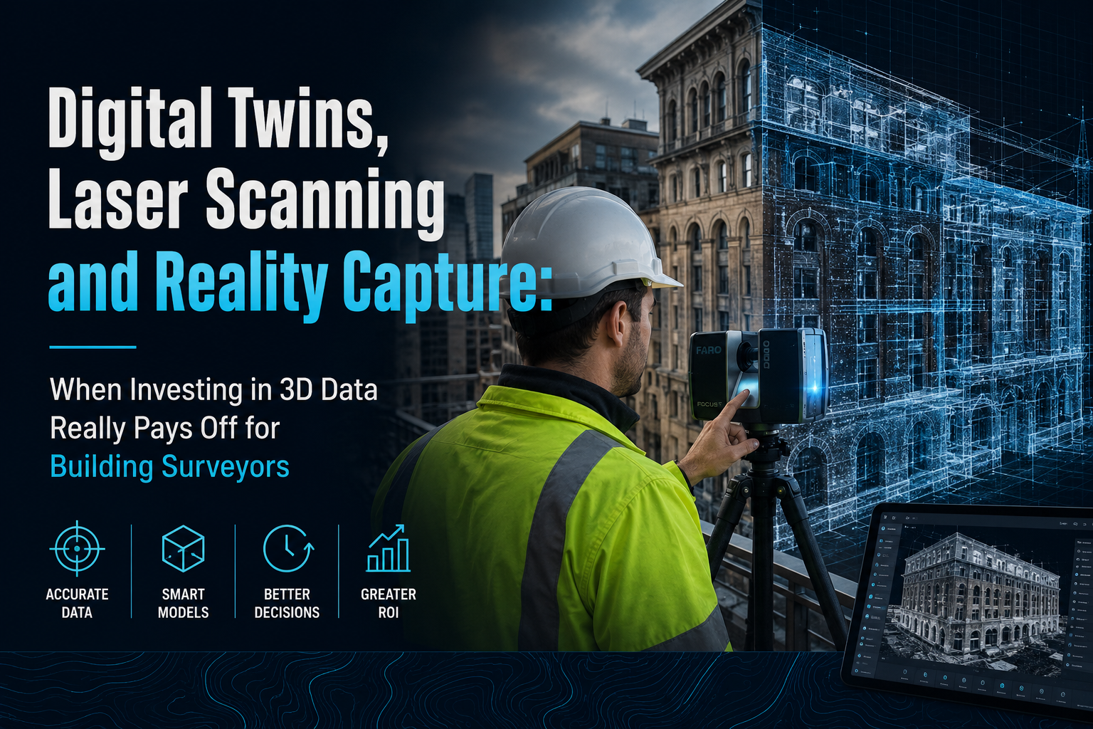
Rework costs on UK construction projects average between 5% and 15% of total contract value — a significant proportion of which traces back to inaccurate or incomplete as-built information. That single statistic reframes the entire conversation around Digital Twins, Laser Scanning and Reality Capture: When Investing in 3D Data Really Pays Off for Building Surveyors. The question is no longer whether 3D data technologies are impressive. The question is: in which specific project types does the investment demonstrably outperform traditional survey methods in terms of time saved, risk reduced, and disputes avoided?
This article cuts through the technology hype and focuses on the concrete case types — heritage assets, complex mechanical and electrical environments, high-rise residential blocks — where UK building surveyors are seeing measurable returns. It also addresses the real implementation challenges that firms must plan for before committing budget.
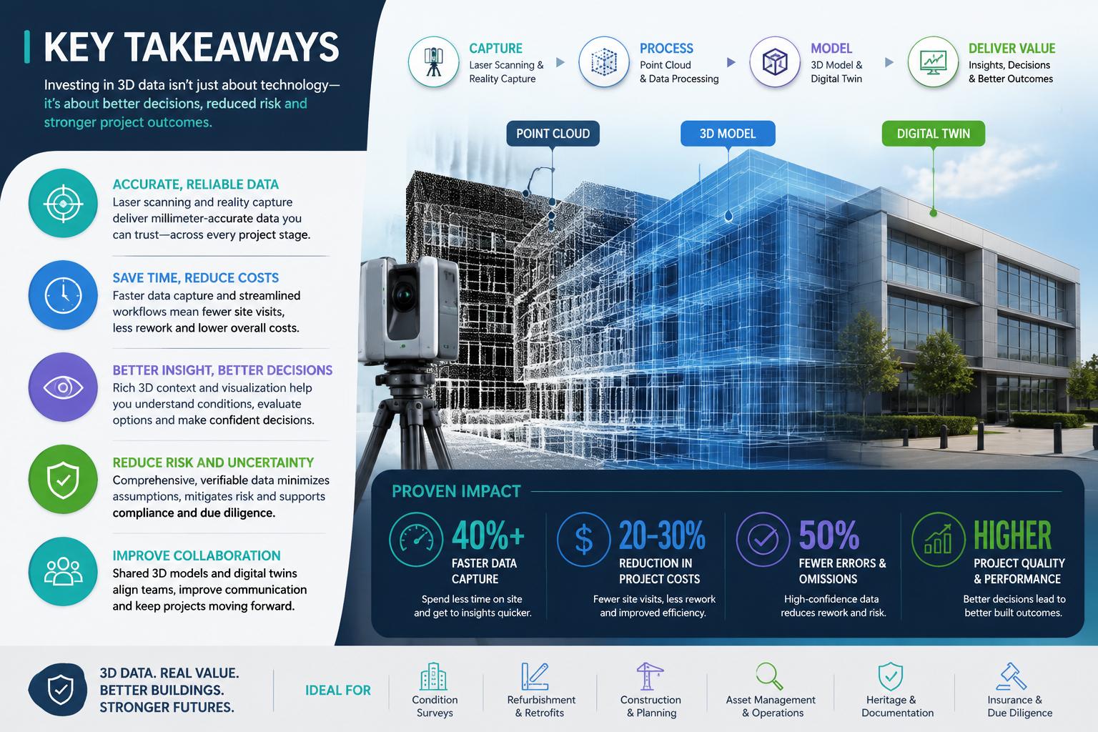
Key Takeaways
- Laser scanning delivers survey-grade accuracy of ±2 mm to ±3 mm, dramatically reducing measurement errors on complex or heritage buildings [1][7]
- Digital twins built from reality capture data reduce rework, dispute exposure, and repeat site visits across the full building lifecycle
- Heritage assets, high-rise blocks, and buildings with dense M&E systems represent the highest-value use cases for 3D data investment
- Integration challenges — large file sizes, software compatibility, and staff training — remain genuine barriers that require planned mitigation [4]
- Surveyors who understand what a measured survey involves are better positioned to evaluate when laser scanning adds genuine value over conventional methods
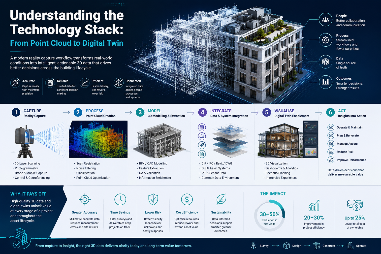
Understanding the Technology Stack: From Point Cloud to Digital Twin
Before evaluating return on investment, it helps to understand what the technology actually produces and how each layer connects.
Reality capture is the umbrella term for any process that records the physical world in digital form. The two dominant methods used in building surveying are:
- Terrestrial laser scanning (TLS): A static tripod-mounted scanner emits millions of laser pulses per second, measuring distances to surfaces and generating a dense "point cloud" — a three-dimensional map of the space accurate to ±2 mm [1][7]
- Photogrammetry and drone capture: Overlapping photographs are processed by software to reconstruct 3D geometry, often used for exteriors, roofs, and large-scale site surveys [3]
Some firms combine mobile mapping, terrestrial scanning, and drone photogrammetry in a single site visit to capture both interior and exterior conditions simultaneously [3].
A point cloud on its own is raw data. It becomes operationally useful when converted into:
| Output Type | Primary Use |
|---|---|
| BIM model (Revit/IFC) | Design coordination, planning applications |
| 2D CAD drawings | Traditional measured survey deliverables |
| 360-degree walkthrough | Client presentations, remote access |
| Digital twin | Live or periodic condition monitoring |
A digital twin is the most sophisticated output: a dynamic, data-rich virtual replica of a building that can be updated over time and integrated with sensor data, maintenance records, and energy performance information [8]. Platforms such as Autodesk and Procore support direct integration with reality capture outputs, enabling surveyors to deliver interactive digital twins that slot into existing design and construction workflows [2].
Data delivery timelines have compressed considerably. Specialist providers now offer precision reality capture at ±3 mm accuracy with processed data delivered within 24 to 72 hours [7], which makes the technology viable for time-sensitive transactions and pre-acquisition surveys.
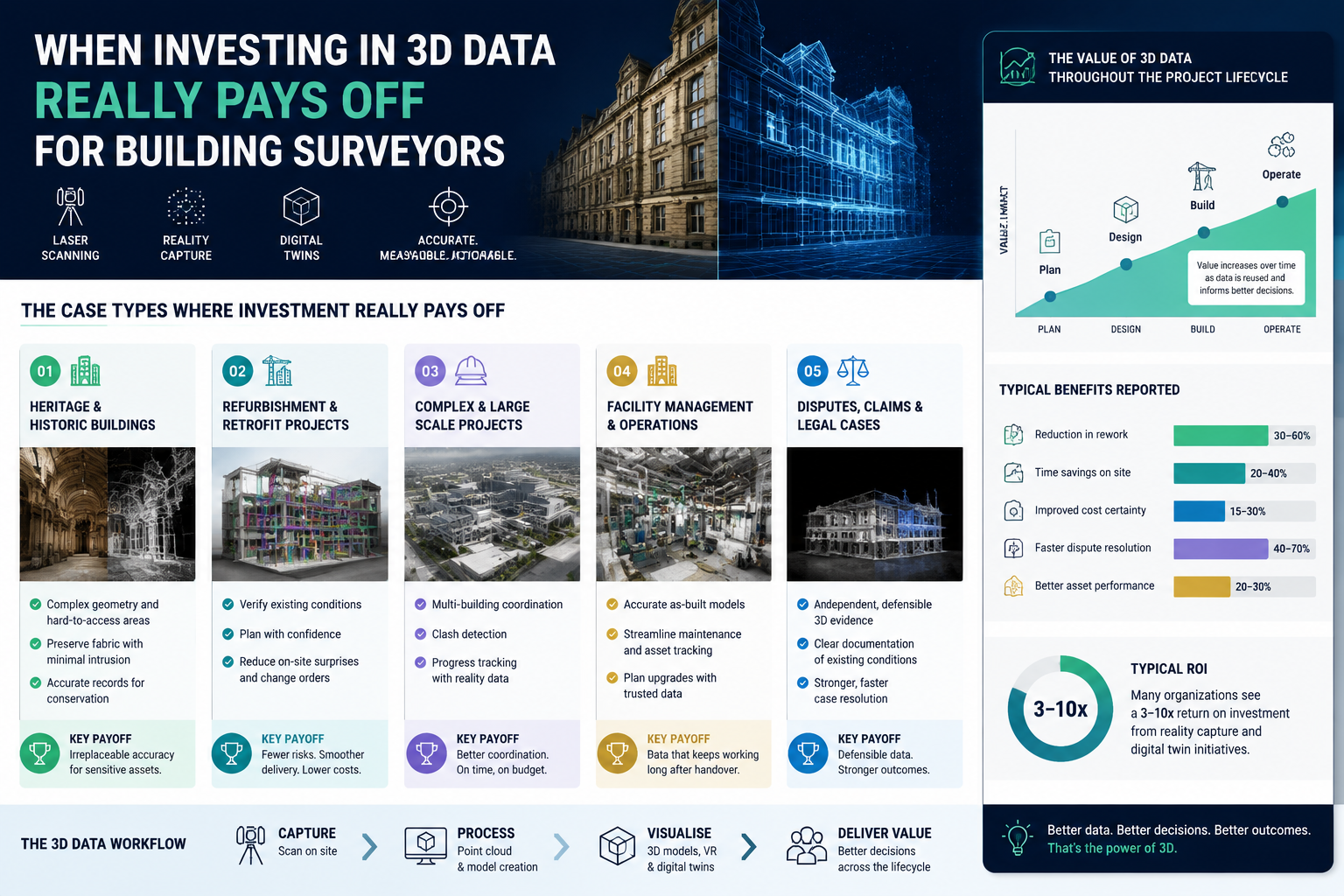
Digital Twins, Laser Scanning and Reality Capture: The Case Types Where Investment Really Pays Off
Not every building survey justifies the cost of full laser scanning. The return on investment is highest where one or more of the following conditions apply: the building geometry is complex or undocumented, access is difficult or dangerous, the risk of error carries significant financial or legal consequence, or the asset will be surveyed repeatedly over its lifecycle.
Heritage and Listed Buildings
Heritage assets represent perhaps the clearest high-value use case. Older buildings — Georgian townhouses, Victorian warehouses, listed churches — were constructed before standardised dimensions existed. Floor plans held at the Land Registry or local authority are frequently inaccurate, incomplete, or simply absent.
For surveyors working on listed buildings and conservation areas, the consequences of measurement error are severe. Planning applications, consent for works, and party wall matters all depend on accurate dimensional data. A single incorrect floor area can affect lease valuations, dilapidations assessments, and reinstatement cost calculations.
Laser scanning resolves this problem at source. A full interior and exterior scan of a complex listed building can be completed in a single day, producing a millimetre-accurate point cloud that eliminates the need for multiple return visits. The resulting BIM model or 2D CAD output becomes a permanent, reusable asset — one that can be interrogated by architects, structural engineers, and conservation officers without anyone needing to re-enter the building.
"The point cloud does not forget. Every dimension, every quirk of the geometry, every deviation from plumb is captured and queryable for the life of the project."
This reusability is where the economics become compelling. On a heritage refurbishment project, the same scan data may serve the planning application, the contractor's tender package, the structural engineer's assessment, and the post-works record drawings. The cost of scanning is incurred once; the savings accumulate across every downstream use.
High-Rise Residential Blocks
Post-Grenfell, the regulatory environment for high-rise residential buildings in England has fundamentally changed. The Building Safety Act 2022 introduced the concept of the "golden thread" of building information — a requirement that key safety-critical data be maintained and accessible throughout a building's lifecycle.
For surveyors working on blocks of 18 metres or above, digital twins built from laser scan data are becoming a practical response to this requirement rather than an optional enhancement. An accurate, georeferenced 3D model of a high-rise block provides:
- Verified floor-to-floor heights and compartmentation geometry
- Documented cladding system dimensions for remediation planning
- A baseline record against which future condition surveys can be compared
- Evidence of building configuration that can be shared with the Building Safety Regulator
The risk reduction argument is equally strong. Surveyors conducting level 3 full building surveys on high-rise blocks face genuine access challenges — plant rooms, roof plant, external elevations above working-at-height thresholds. Drone photogrammetry and long-range scanning reduce the need for scaffolding, rope access, or cherry picker hire, cutting both cost and programme time.
Buildings with Complex M&E Systems
Commercial and industrial buildings with dense mechanical, electrical, and plumbing (M&E) installations present a different but equally compelling case. Existing drawings for these systems are frequently out of date, reflecting the original design intent rather than what was actually installed or subsequently modified.
Reality capture methods, including laser scanning and photogrammetry, document existing conditions with laboratory-level precision, enabling faster remodels, retrofits, and renovations with fewer errors [2]. When a surveyor is preparing a dilapidations schedule or advising on a fit-out, having an accurate 3D record of existing M&E routes, duct sizes, and service void dimensions can prevent costly clashes during construction.
The dispute reduction benefit here is significant. A georeferenced point cloud taken at lease expiry provides an objective, timestamped record of building condition that is far harder to challenge than a written schedule supported by photographs. In dilapidations disputes, where the financial stakes can run to hundreds of thousands of pounds, that evidential quality has real monetary value.
Overcoming the Real Implementation Challenges
The technology case is strong, but the Digital Twin Consortium is direct about the obstacles: adopting reality capture for digital twins requires appropriate devices, the ability to manage large data files, and extensive training [4]. Firms that underestimate these requirements tend to invest in hardware and software that then sits underused.
Data Management
A single terrestrial laser scan of a medium-sized building can generate point cloud files of 10 to 50 gigabytes. A whole-building scan of a complex asset may produce several hundred gigabytes. Without a structured data management workflow — including cloud storage, processing pipelines, and version control — this data quickly becomes unmanageable.
Practical mitigations include:
- Using specialist reality capture providers rather than purchasing hardware outright, particularly for firms that scan fewer than 10 to 15 buildings per year
- Establishing clear output specifications before scanning begins (BIM LOD level, required 2D views, file format) to avoid processing unnecessary data
- Adopting cloud-based platforms that allow stakeholders to access and interrogate models without needing local processing power
Software Compatibility and Interoperability
A 2025 expert survey identified significant challenges in integrating diverse digital models within digital twins, including the absence of standardised interfaces and limited support for model reuse across lifecycle phases [5]. In practical terms, this means a point cloud processed in one software environment may not import cleanly into a client's preferred BIM platform.
The most reliable approach is to agree on deliverable formats at the outset and to work with providers who offer point cloud conversion into Revit-ready as-builts and 2D CAD outputs as standard [9]. Surveyors advising clients on statutory considerations for building works should also confirm that digital models meet the format requirements of the relevant planning or building control authority.
Training and Workflow Integration
The most capable scanning hardware is only as useful as the surveyor's ability to interpret and apply the output. Training requirements span both the data capture process and the downstream software — point cloud processing, BIM authoring, and digital twin platforms each require distinct skill sets.
Firms considering in-house capability should budget for formal training, allow for a productivity dip during the transition period, and identify a champion within the team who can drive adoption. Alternatively, partnering with specialist reality capture providers for the data collection phase while retaining interpretation and reporting in-house is a lower-risk entry point.
Evaluating Return on Investment: A Practical Framework
The decision to invest in 3D data should be driven by project economics, not technology enthusiasm. The following framework helps surveyors assess whether laser scanning and digital twin outputs are justified for a specific commission.
Step 1 — Quantify the cost of error. What is the financial consequence if the as-built dimensions are wrong? For a straightforward residential purchase, the answer may be low. For a heritage refurbishment, a dilapidations dispute, or a high-rise safety case, the answer may be very high.
Step 2 — Assess reuse potential. Will the scan data be used by multiple parties — architect, structural engineer, contractor, client — or only once? Multi-use data has a lower effective cost per application.
Step 3 — Consider access risk. Does the survey require working at height, entry into confined spaces, or repeated visits to a live operational environment? Scanning reduces exposure to these risks.
Step 4 — Check client lifecycle intent. Is the client planning to hold and manage the asset long-term? A digital twin that supports ongoing building maintenance and condition monitoring delivers value over years, not just at the point of survey.
Step 5 — Compare provider options. For firms not scanning regularly, specialist providers offer survey-grade accuracy at competitive day rates [1][7], making outsourcing more cost-effective than capital investment in hardware.
Emerging Developments Worth Monitoring in 2026
The technology continues to evolve. Two developments are particularly relevant for building surveyors.
Gaussian Splat modelling — a technique that uses overlapping images to generate photorealistic 3D representations — is being developed for defect detection applications. Early research has demonstrated an average defect detection accuracy of 83% across varied objects [6], suggesting potential future applications in condition survey automation.
Automated model composition is another area of active research. Current digital twin workflows require significant manual effort to assemble and maintain models from multiple data sources. Emerging work on semantics-based interoperability aims to automate this process, reducing the time and cost of keeping digital twins current [5].
Surveyors who want to stay informed about how these developments affect professional practice should consider engaging with CPD events and industry forums as these technologies mature.
Conclusion
Digital Twins, Laser Scanning and Reality Capture: When Investing in 3D Data Really Pays Off for Building Surveyors is not a question with a single universal answer — it depends on project type, asset complexity, and the financial stakes attached to measurement accuracy. What the evidence does confirm is that for heritage assets, high-rise residential blocks, and buildings with complex M&E systems, the investment case is robust and well-supported by measurable reductions in rework, repeat site visits, and dispute exposure.
Actionable next steps for building surveyors in 2026:
- Identify the three to five commission types in your current workload where measurement error carries the highest financial consequence — these are your priority candidates for laser scanning
- Request sample deliverables from at least two specialist reality capture providers and compare accuracy specifications, file formats, and turnaround times
- Review your standard terms of engagement to ensure they address digital deliverable ownership, data retention, and format specifications
- If advising clients on complex assets, consider recommending a full building survey that incorporates reality capture outputs as part of the scope, particularly where the asset will be held long-term
- Engage with the surveying community to share experience and build collective knowledge about which workflows deliver the best results in practice
The firms that will benefit most from 3D data are not necessarily those that invest earliest in hardware. They are those that develop the clearest understanding of when the technology genuinely changes the outcome — and when a well-executed traditional survey remains the right tool for the job.
References
[1] zealotrecap – https://zealotrecap.com/?utm_source=openai
[2] Reality Capture And Bim Services – https://sevan.com/reality-capture-and-bim-services/?utm_source=openai
[3] Whole Building Reality Capture – https://www.greenlight-360.com/services/whole-building-reality-capture/?utm_source=openai
[4] Overcoming The Obstacles To Implementing Reality Capture For Digital Twins – https://www.digitaltwinconsortium.org/2022/09/overcoming-the-obstacles-to-implementing-reality-capture-for-digital-twins/?utm_source=openai
[5] arxiv – https://arxiv.org/abs/2506.17313?utm_source=openai
[6] arxiv – https://arxiv.org/abs/2508.00354?utm_source=openai
[7] dcmssystems – https://dcmssystems.com/?utm_source=openai
[8] Reality Capture – https://www.digitaltwin-solutions.com/services/reality-capture/?utm_source=openai
[9] atoryco – https://atoryco.com/?utm_source=openai