Nearly 40% of residential property transactions experienced post-closing disputes in 2025 due to undisclosed defects or boundary conflicts—a statistic that has sent shockwaves through an already cautious market. As buyers and lenders demand ironclad assurances before committing capital, the surveying profession has responded with the most comprehensive protocol overhaul in decades. Building Survey Protocols for Greater Transaction Certainty: 2026 Tools Amid Risk-Averse Residential Markets represents not merely a standards update, but a fundamental shift toward transparency, precision, and defensible property intelligence that addresses the core anxieties plaguing today's risk-averse stakeholders.
The February 23, 2026 implementation of revised ALTA/NSPS Land Title Survey standards marks a watershed moment for transaction security [1]. These enhanced protocols deliver measurably greater confidence in boundary resolution, easement identification, and encroachment detection—precisely the assurances that nervous buyers and cautious lenders desperately need in sluggish market conditions [3].
Key Takeaways
- New 2026 standards took effect February 23, 2026, superseding all 2021 protocols and establishing higher benchmarks for data clarity and measurement precision [1][2]
- Enhanced transparency requirements now mandate comprehensive surveyor notes explaining discrepancies, access limitations, and easement status directly on survey faces [2]
- Expanded certification flexibility allows surveyors to certify directly to lenders' successors and assigns, facilitating commercial financing structures and secondary market transactions [3]
- Risk mitigation focus addresses market anxiety through systematic checklists, data-driven reporting, and clearer communication between surveyors and title insurers [6]
- Minimal cost impact for most transactions, though enhanced documentation and records research may add modest timing considerations for complex properties [3]
Understanding Building Survey Protocols for Greater Transaction Certainty in 2026
The foundation of transaction certainty rests on systematic, defensible property intelligence. Modern building survey protocols have evolved from simple boundary identification to comprehensive risk assessment frameworks that address every stakeholder concern.
What Makes 2026 Standards Different
The 2026 Minimum Standard Detail Requirements for ALTA/NSPS Land Title Surveys represent a deliberate response to market demands for greater certainty [1]. Unlike previous updates that primarily refined technical specifications, the 2026 revision fundamentally restructures how surveyors communicate findings and collaborate with title insurers.
Key distinctions include:
- 📋 Mandatory disclosure protocols requiring surveyors to document all discrepancies between recorded and measured data
- 🔍 Enhanced easement classification with five distinct status categories (shown, cannot be located, blanket, illegible, or not affecting property) [2]
- 📊 Expanded certification scope enabling direct certification to loan assignees and secondary market purchasers [3]
- ⚖️ Clarified legal boundaries distinguishing surveyor observations from legal opinions on ownership or encroachment [4]
The Risk-Averse Market Context
Current residential markets exhibit unprecedented caution. Buyers demand exhaustive due diligence before committing. Lenders require bulletproof documentation to justify loan approvals. Sellers face intense scrutiny of property conditions. This environment creates perfect conditions for enhanced survey protocols to deliver measurable value.
The 2026 standards acknowledge this reality by emphasizing supporting documentation, transparency regarding encumbrances, and surveyor-title insurer coordination [2]. These aren't merely technical improvements—they're strategic responses to market psychology.
Core Components of Building Survey Protocols for Greater Transaction Certainty: 2026 Tools
Effective survey protocols function as systematic risk mitigation frameworks. Understanding their components helps stakeholders leverage them for maximum transaction security.
Enhanced Data Clarity and Measurement Precision
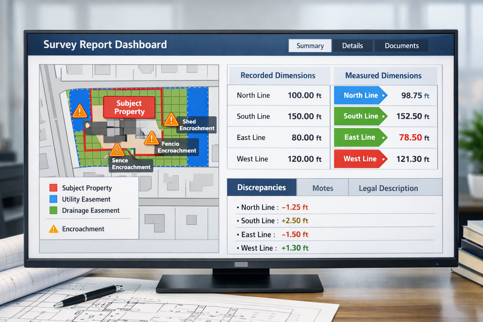
The 2026 revision raises benchmarks for data clarity, measurement precision, and defensible property intelligence [1]. This translates to tangible improvements in how surveys communicate critical information.
Measurement precision enhancements:
| Aspect | Previous Standard | 2026 Enhancement |
|---|---|---|
| Boundary markers | Basic identification | GPS coordinates + condition assessment |
| Dimension reporting | Single measurement | Recorded vs. measured comparison with variance notes |
| Easement location | General indication | Precise mapping with access implications |
| Encroachment detection | Visual observation | Measured offset distances with significance assessment |
These improvements directly address the most common sources of post-closing disputes. When buyers understand exactly where boundaries fall and how easements impact property use, transaction confidence increases dramatically.
Comprehensive Transparency Requirements
Perhaps the most impactful change involves comprehensive notes on survey faces when discrepancies arise [2]. Surveyors must now provide:
✅ Explanations for differences between recorded and measured distances
✅ Reasons for new legal descriptions when necessary
✅ Documentation of access limitations that prevented complete inspection
✅ Notification protocols when recorded easements don't appear in title materials
This transparency eliminates the ambiguity that historically fueled transaction delays and post-closing conflicts. Stakeholders receive complete information upfront, enabling informed decision-making rather than unpleasant surprises.
Shifted Records Research Responsibility
A subtle but significant change involves records research obligations. Surveyors are no longer entirely reliant on title insurers to provide adjoining property deeds and may now need to obtain those records independently [3].
This shift has implications:
- 🕐 Modest timing impacts as surveyors conduct additional research
- 💰 Potential cost adjustments reflecting expanded research scope
- 🎯 Greater accuracy through direct source verification
- 🤝 Enhanced collaboration between surveyors and title professionals
For most residential transactions, these impacts remain minimal. However, complex properties with numerous adjoining parcels or unclear historical records may experience slightly extended timelines [3].
Implementing Building Survey Protocols for Greater Transaction Certainty: Practical Tools and Checklists
Theory matters little without practical implementation. Successful deployment of 2026 protocols requires systematic approaches that ensure nothing falls through cracks.
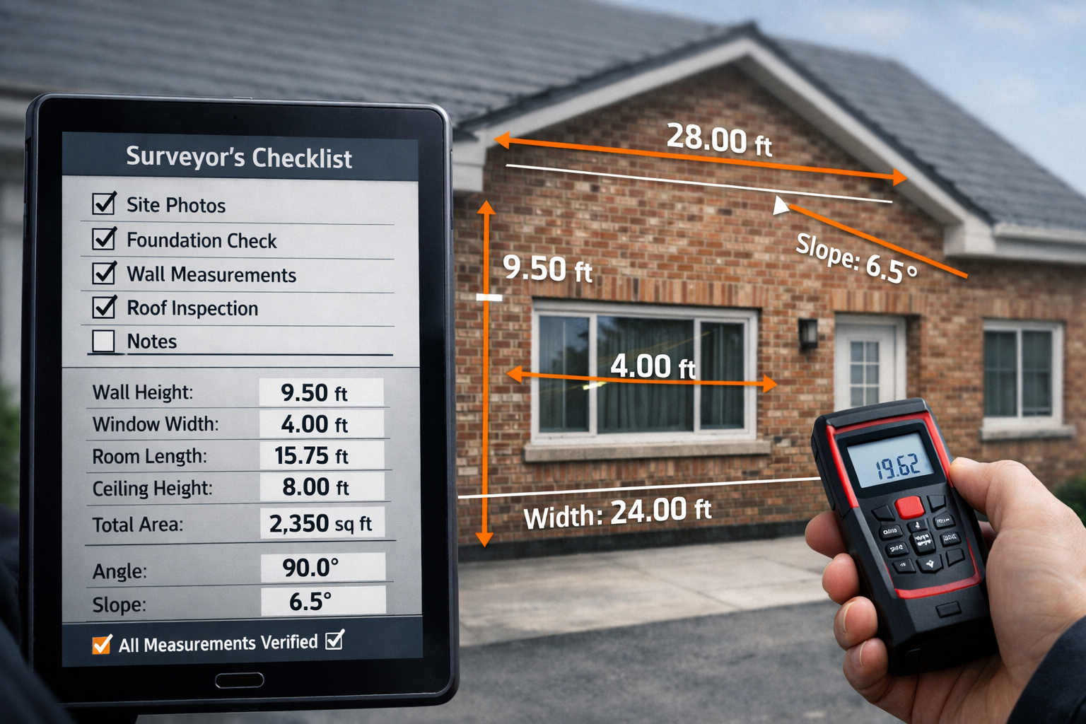
The Essential Survey Checklist for 2026
Professional surveyors now employ comprehensive checklists that address every standard requirement. Buyers and their representatives should verify these elements:
Pre-Survey Preparation:
- Property deed and legal description review
- Title commitment examination
- Identification of Table A optional items requested
- Coordination with title insurer on easement documentation
- Access arrangements with current property occupants
Field Investigation Requirements:
- Complete boundary traverse with precision GPS
- Physical monument identification and condition assessment
- Improvement location measurements (buildings, fences, driveways)
- Easement corridor inspection and access evaluation
- Encroachment detection through measured offsets
- Utility location identification (visible and marked underground)
- Topographic features affecting property use
Documentation and Reporting:
- Recorded vs. measured dimension comparison tables
- Comprehensive discrepancy explanations
- Easement status classification for each recorded encumbrance
- Access limitation notes with impact assessment
- Certification to all required parties including assigns
- Supporting documentation appendix
This systematic approach ensures comprehensive building inspections that leave no stone unturned.
New Table A Item 20: Encroachment Opinions
The 2026 standards introduce optional Table A Item 20 requiring surveyors to opine on significant observations such as potential encroachments [4]. This represents a carefully calibrated expansion of surveyor responsibilities.
Key parameters:
- 📝 Surveyors provide observations on apparent encroachments, not legal conclusions
- ⚖️ Clear distinction maintained between surveyor opinions and legal determinations of ownership
- 🎯 Focus on significant observations rather than trivial matters
- 💼 Optional item must be specifically requested by client or title insurer
This addition addresses a longstanding gap where surveyors identified potential issues but couldn't formally comment without overstepping professional boundaries. The new framework provides appropriate scope for professional judgment while maintaining legal distinctions [4].
Enhanced Easement Reporting Standards
Easements historically caused confusion when survey depictions conflicted with title descriptions. The 2026 standards establish clear indication requirements for easement status [2]:
Five-Category Classification System:
- Shown – Easement physically located and depicted on survey
- Cannot be located – Recorded easement without identifiable physical evidence
- Blanket easement – General grant without specific location description
- Illegible – Recorded document too degraded for interpretation
- Does not affect property – Easement recorded but applies to different parcel
Additionally, surveyors must notify title insurers of recorded easements not listed in title materials [2]. This cross-checking mechanism catches documentation gaps before they become transaction obstacles.
Understanding which building survey you need depends partly on easement complexity. Properties with numerous recorded encumbrances benefit from the most comprehensive survey levels.
Risk Mitigation Through Building Survey Protocols for Greater Transaction Certainty: 2026 Tools in Practice
The ultimate test of any protocol lies in practical risk reduction. How do 2026 standards actually protect transaction participants?
For Buyers: Confidence Through Comprehensive Disclosure
Risk-averse buyers gain multiple protections:
Boundary certainty – Precise measurements eliminate ambiguity about property extent and potential neighbor disputes. Knowing exactly where property lines fall prevents costly conflicts.
Easement clarity – Understanding access rights, utility corridors, and use restrictions enables informed decisions about property suitability. The five-category classification system eliminates guesswork [2].
Encroachment detection – Measured offsets identify structures, fences, or improvements that cross boundary lines. Optional surveyor opinions on significance help buyers assess risk [4].
Defect transparency – Comprehensive notes on access limitations or measurement discrepancies ensure buyers understand survey scope and any areas requiring additional investigation [2].
When considering full building survey vs homebuyer survey options, the enhanced 2026 protocols make comprehensive surveys even more valuable in uncertain markets.
For Lenders: Defensible Documentation for Loan Security
Financial institutions face regulatory scrutiny and portfolio risk. Enhanced survey protocols deliver critical protections:
- 🏦 Expanded certification to successors and assigns protects loan sale and syndication structures [3]
- 📋 Comprehensive documentation supports loan file completeness for regulatory examination
- ⚖️ Clarified easement termination standards reduce uncertainty about encumbrance validity [3]
- 🔍 Enhanced transparency regarding property boundaries protects collateral value
The ability to certify surveys directly to loan assignees represents a significant practical improvement for commercial lending and secondary market transactions [3]. This flexibility reduces friction in loan transfers and portfolio management.
For Sellers: Proactive Risk Management
Savvy sellers increasingly commission surveys before listing properties. The 2026 standards make this strategy even more valuable:
Proactive disclosure – Identifying boundary issues, easements, or encroachments before marketing enables sellers to address problems or price accordingly.
Transaction acceleration – Providing comprehensive survey documentation upfront eliminates buyer due diligence delays and demonstrates transparency.
Negotiation leverage – Professional survey documentation supports asking prices and reduces buyer leverage for price reductions based on uncertainty.
Reduced liability – Comprehensive disclosure reduces post-closing dispute risk and potential legal exposure.
Understanding how to negotiate house price down after survey becomes less relevant when sellers provide thorough documentation upfront.

Cost and Timing Considerations for 2026 Survey Protocols
Enhanced standards naturally raise questions about practical impacts on transaction timelines and budgets.
Limited Impact for Most Transactions
Industry analysis indicates that 2026 revisions do not materially expand survey scope, cost, or timing in most real estate transactions [2]. The enhancements primarily affect documentation and communication rather than field investigation scope.
Typical residential transaction impacts:
- 📅 Timeline: 0-3 additional business days for enhanced documentation
- 💰 Cost: 0-10% increase for standard properties
- 📋 Deliverables: More comprehensive reporting with minimal additional surveyor time
Scenarios Requiring Additional Resources
Certain property characteristics may trigger more substantial impacts:
Complex boundary histories – Properties with numerous subdivisions, unclear historical records, or conflicting deed descriptions require additional research time and potentially higher costs [3].
Multiple easements – Properties burdened by numerous recorded easements need comprehensive research and classification under the five-category system [2].
Access limitations – Properties where complete inspection proves impossible require extensive documentation of limitations and their implications [2].
Adjoining parcel research – When title insurers don't provide complete adjoining property deeds, surveyors must obtain records independently, adding research time [3].
For guidance on budgeting, review information on cost of measured building surveys and what measured building surveys entail.
Value Proposition in Risk-Averse Markets
Even when 2026 protocols add modest costs, the value proposition remains compelling in uncertain markets. Transaction certainty justifies incremental investment when:
- 🏠 Property values represent significant capital commitments
- ⚖️ Boundary or easement questions could materially impact use
- 💼 Lenders require comprehensive documentation for loan approval
- 🤝 Multiple parties need assurance for transaction completion
The cost of building defects discovered post-purchase typically dwarfs survey expenses, making comprehensive protocols a prudent investment.
Coordination Between Surveyors and Title Professionals
The 2026 standards explicitly recognize that transaction certainty requires collaboration between surveyors and title insurers.
Enhanced Communication Protocols
New requirements mandate surveyor notification when recorded easements don't appear in title materials [2]. This cross-checking mechanism prevents documentation gaps that historically caused closing delays.
Collaborative workflow improvements:
- Pre-survey coordination – Title insurers provide comprehensive easement lists; surveyors identify any additional recorded encumbrances
- Mid-survey communication – Surveyors alert title professionals to discrepancies or concerns requiring research
- Post-survey review – Joint examination of findings ensures all parties understand implications
- Closing preparation – Coordinated documentation packages address all identified issues
Clarified Professional Boundaries
The 2026 standards carefully delineate surveyor versus attorney responsibilities. Surveyors provide observations and measurements; attorneys provide legal opinions on ownership and rights [4].
This clarity prevents confusion while enabling appropriate professional input from each discipline. Buyers receive comprehensive information without inappropriate overlap or gaps in professional services.
Understanding statutory considerations in building surveys and when construction law advice becomes necessary helps stakeholders coordinate appropriate professional teams.
Technology Integration in 2026 Survey Protocols
While standards don't mandate specific technologies, modern survey practices increasingly leverage digital tools that enhance accuracy and transparency.
Digital Measurement and Documentation
Contemporary surveyors employ:
- 📡 GPS/GNSS technology for sub-centimeter boundary positioning accuracy
- 📏 Laser scanning for comprehensive improvement measurement and 3D modeling
- 🖥️ Digital drafting systems enabling dynamic survey documents with layered information
- 📱 Mobile field applications for real-time data collection and photo documentation
- ☁️ Cloud platforms facilitating secure document sharing with transaction parties
These technologies support 2026 requirements for enhanced precision and comprehensive documentation [1].
Data-Driven Reporting
Modern survey reports increasingly incorporate:
Interactive digital formats – Clickable easement references linking to recorded documents, zoomable boundary details, and layered information display.
Comparative analysis tables – Side-by-side recorded versus measured dimensions with calculated variances and statistical confidence intervals.
Photographic documentation – Geotagged field photos documenting monuments, improvements, easement corridors, and potential encroachments.
3D visualization – Three-dimensional property models showing topography, improvements, easements, and boundary relationships.
These enhancements transform surveys from static documents into dynamic information resources that support informed decision-making.
Special Considerations for Different Property Types
While 2026 standards apply universally, practical implementation varies by property type.
Residential Properties
Standard residential transactions benefit most from:
- Clear boundary identification preventing neighbor disputes
- Easement classification clarifying access rights and utility corridors
- Encroachment detection identifying fence, driveway, or structure issues
- Comprehensive notes explaining any measurement discrepancies
For new construction, review guidance on whether you need a survey on a new build and considerations for older properties.
Commercial Properties
Commercial transactions typically require:
- Expanded Table A optional items including parking calculations, zoning compliance, and access analysis
- Certification to multiple parties including lenders, investors, and their assigns [3]
- Detailed easement analysis for operational implications
- Comprehensive encroachment assessment affecting tenant use
Complex or High-Value Properties
Properties with unique characteristics benefit from:
- Optional Table A Item 20 requesting surveyor opinions on significant observations [4]
- Enhanced boundary research for historical properties with unclear records
- Comprehensive easement investigation for properties with multiple encumbrances
- Detailed topographic analysis for development potential assessment
Understanding building materials assessments and specialized survey components helps stakeholders specify appropriate scope.
Future Outlook: Evolution of Survey Protocols
The 2026 standards represent current best practices, but the profession continues evolving.
Anticipated Developments
Industry observers expect continued emphasis on:
Technology integration – Increased adoption of AI-assisted document analysis, automated discrepancy detection, and predictive modeling for encroachment risk.
Standardized digital formats – Development of universal data exchange standards enabling seamless integration with title, lending, and closing systems.
Enhanced risk quantification – More sophisticated statistical analysis of measurement uncertainty and confidence intervals for critical dimensions.
Sustainability considerations – Integration of environmental factors, climate risk assessment, and green building verification into survey protocols.
Regulatory Trends
Regulatory developments may drive further enhancements:
- Federal lending agencies potentially mandating enhanced survey standards for loan programs
- State licensing boards adopting 2026 standards as minimum professional requirements
- Title insurance underwriters requiring compliance for policy issuance
- Professional liability insurers offering premium incentives for enhanced protocol adoption
Conclusion
Building Survey Protocols for Greater Transaction Certainty: 2026 Tools Amid Risk-Averse Residential Markets represents a fundamental shift in how the surveying profession supports real estate transactions. The February 23, 2026 implementation of revised ALTA/NSPS standards delivers measurably enhanced transparency, precision, and defensible property intelligence that directly addresses stakeholder anxieties in cautious markets [1][2].
The core improvements—comprehensive discrepancy documentation, five-category easement classification, expanded certification flexibility, and optional encroachment opinions—provide tangible risk mitigation without materially expanding costs or timelines for most transactions [2][3][4]. These enhancements transform surveys from simple boundary identification into comprehensive risk assessment frameworks that support informed decision-making.
Actionable Next Steps
For buyers: Commission comprehensive surveys early in due diligence periods. Specify optional Table A items addressing specific property concerns. Review survey findings with qualified professionals before waiving contingencies.
For sellers: Consider proactive survey commissioning before marketing to identify and address issues upfront. Use comprehensive documentation to support pricing and demonstrate transparency.
For lenders: Update loan documentation to reference 2026 standards. Ensure underwriting guidelines reflect enhanced survey capabilities. Leverage expanded certification provisions for portfolio management.
For all stakeholders: Partner with qualified surveyors experienced in 2026 protocols. Prioritize comprehensive documentation over minimal compliance. Recognize that transaction certainty justifies appropriate investment in professional services.
The risk-averse residential market of 2026 demands nothing less than complete transparency and defensible property intelligence. Enhanced survey protocols deliver exactly that—transforming uncertainty into confidence and enabling transactions that might otherwise falter. In an environment where trust remains scarce, systematic, data-driven survey protocols provide the foundation for successful property transfers.
For comprehensive building survey services employing the latest 2026 protocols, explore professional building survey options that deliver the transaction certainty today's markets demand.
References
[1] Alta Surveys Revised 2026 – https://www.bvna.com/needs/alta-surveys-revised-2026
[2] 2026 Alta Survey Standards Updates – https://www.hklaw.com/en/insights/publications/2026/03/2026-alta-survey-standards-updates
[3] 2026 Alta Nsps Survey Standards Update Key Takeaways For Commercial Real Estate – https://www.taftlaw.com/news-events/law-bulletins/2026-alta-nsps-survey-standards-update-key-takeaways-for-commercial-real-estate/
[4] Nsps Land Title – https://www.parkerpoe.com/news/2026/02/key-takeaways-from-the-2026-alta/nsps-land-title
[5] 2026 Alta Nsps Standards What Changed From 2021 – https://www.builoff.com/blog-posts/2026-alta-nsps-standards-what-changed-from-2021
[6] Key Updates 2026 Alta Nsps Land Title 4135295 – https://www.jdsupra.com/legalnews/key-updates-2026-alta-nsps-land-title-4135295/
[7] Effective February 23 2026 Changes In The Minimum Standard Detail Requirements For Alta Nsps Land Title Surveys – https://www.lewisrice.com/publications/effective-february-23-2026-changes-in-the-minimum-standard-detail-requirements-for-alta-nsps-land-title-surveys