Construction projects that use Building Information Modeling reduce rework costs by up to 40% compared to those relying on traditional 2D drawings alone — yet only a fraction of surveying professionals have fully embedded BIM workflows into their daily practice. The gap between knowing about BIM and actually deploying it as a core surveying tool represents one of the most significant missed opportunities in the built environment sector today.
Building Information Modeling (BIM) and Surveying: Seamless Integration for Modern Construction is no longer a niche technical topic. It sits at the center of how infrastructure projects are planned, delivered, and managed across their entire lifecycle. Approximately 73% of construction professionals now incorporate BIM into their daily workflows, up from just 10% a decade ago [1]. For surveyors, this shift demands a fundamental rethinking of how spatial data is collected, structured, and handed off to wider project teams.
This article examines how BIM combines survey data with intelligent 3D models for lifecycle project management, with a particular focus on infrastructure investments. It also provides practical workflows for surveyors who are entering BIM environments for the first time or looking to deepen their integration.
Key Takeaways
- BIM adoption has grown from 10% to 73% among construction professionals over the past decade, making integration with surveying workflows essential rather than optional.
- Accurate, structured survey data is the foundation of any reliable BIM model — errors at the data capture stage multiply throughout the entire project lifecycle.
- Total stations, LiDAR scanners, drones, and GPS equipment each feed distinct data types into BIM environments, and surveyors must understand how to format and transfer this data correctly.
- GeoBIM — the fusion of Geographic Information Systems (GIS) with BIM — is transforming infrastructure planning by linking spatial context to building-level detail.
- Surveyors entering BIM workflows benefit most from a phased approach: starting with point cloud integration, then progressing to model authoring and data management roles.
What BIM Actually Means for Surveyors
Building Information Modeling is often described as a 3D modeling process, but that description undersells its scope. BIM is a data management framework. The 3D geometry is simply the visible layer of a much deeper information structure that includes material specifications, cost data, maintenance schedules, energy performance attributes, and legal boundary information.
For surveyors, this distinction matters enormously. The survey is not just a preliminary step that feeds into someone else's model. It is the data backbone upon which every other discipline — architecture, structural engineering, mechanical and electrical design — builds its work. Accurate surveying data is crucial for successful BIM implementation because precision in survey data ensures that BIM models accurately represent real-world conditions, reducing errors and rework during construction [5].
When survey data is imprecise, the consequences cascade. A wall positioned 50mm from its actual location in a BIM model can cause clashes between structural and mechanical systems that are only discovered on site — at significant cost and delay.
Understanding what a measured building survey involves is a useful starting point for surveyors new to BIM, since measured surveys form the most common input data type for BIM model creation.
The Core Technologies Connecting Surveying to BIM
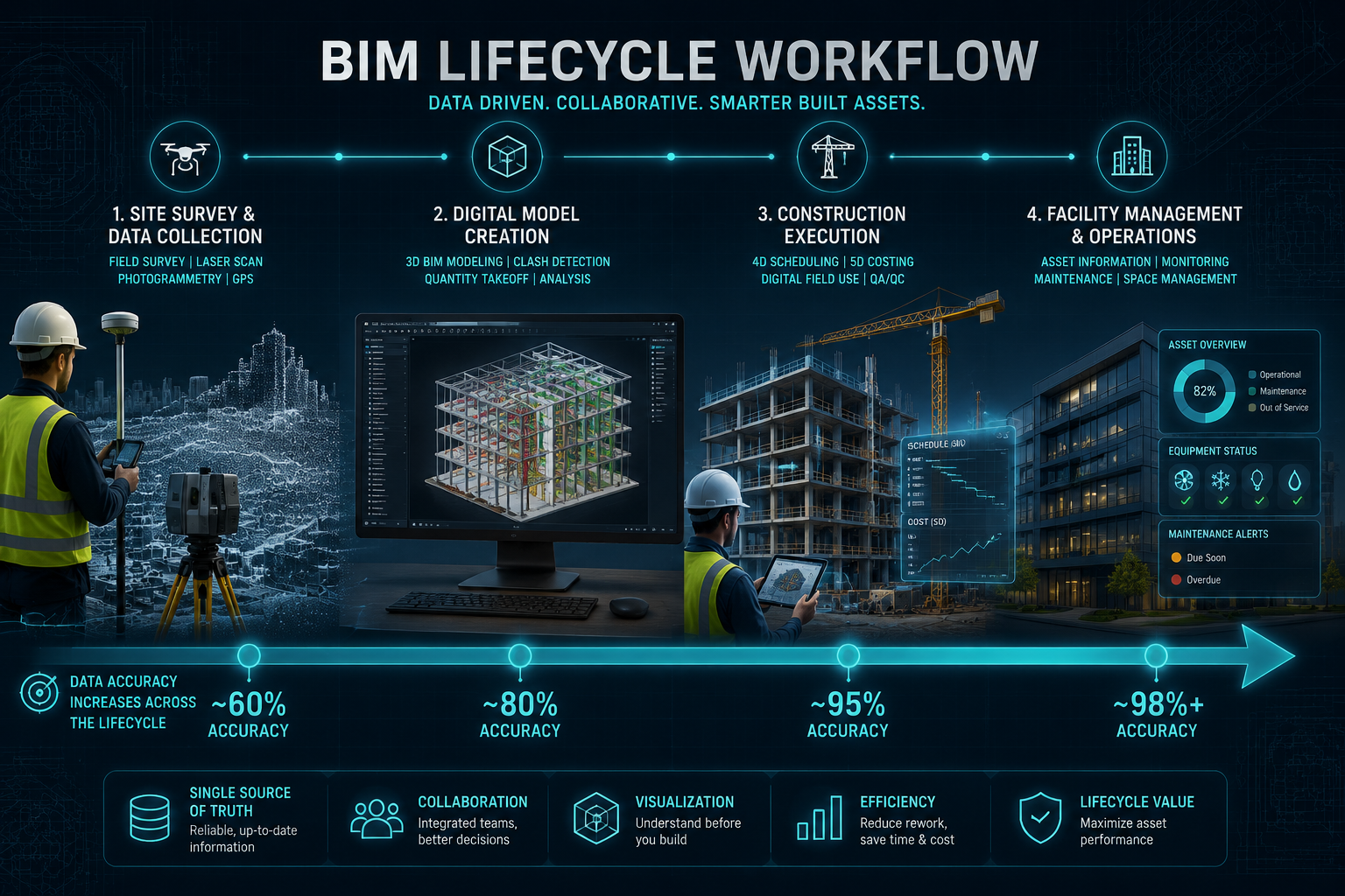
Total Stations and Point Cloud Capture
The combination of total stations and BIM has revolutionized construction accuracy by enabling precise data collection and integration into digital models [3]. Modern robotic total stations can capture thousands of coordinate points per session, and when this data is exported in formats compatible with BIM authoring tools such as Autodesk Revit or Bentley OpenBuildings, it feeds directly into the model coordinate system.
LiDAR (Light Detection and Ranging) scanning takes this further. A terrestrial LiDAR scanner produces a dense point cloud — a three-dimensional constellation of millions of measured points — that can be imported into BIM software as a reference layer. Surveyors then model existing conditions on top of this point cloud with high accuracy.
Key data capture technologies and their BIM applications:
| Technology | Data Output | Primary BIM Use |
|---|---|---|
| Robotic Total Station | Coordinate points | Setting out, as-built verification |
| Terrestrial LiDAR | Dense point cloud | Existing conditions modeling |
| UAV/Drone Photogrammetry | Orthophotos, point cloud | Site topography, roof surveys |
| GNSS/GPS | Georeferenced coordinates | Site positioning, cadastral data |
| Mobile Mapping Systems | Corridor point clouds | Infrastructure and road surveys |
Drone surveys have become particularly valuable for large infrastructure sites where ground-based access is restricted or time-consuming. UAV photogrammetry generates georeferenced orthophotos and point clouds that integrate directly with BIM coordinate systems, enabling rapid site capture at a fraction of the cost of traditional methods.
Data Formatting and Transfer Protocols
One of the most practical challenges surveyors face when entering BIM workflows is understanding data formats. The construction industry has standardized around several exchange formats:
- IFC (Industry Foundation Classes): The open, vendor-neutral format for BIM model exchange. Surveyors should be able to export and import IFC files from their survey software.
- LandXML: Widely used for civil engineering survey data including terrain models, alignments, and cross-sections.
- E57 and LAS/LAZ: Standard point cloud formats compatible with most BIM authoring tools.
- DXF/DWG: Legacy CAD formats that remain common for 2D survey drawings used as BIM references.
Understanding which format a project requires — and ensuring survey equipment and software can export to that format — is a non-negotiable first step for any surveyor entering a BIM project.
Building Information Modeling (BIM) and Surveying: Seamless Integration for Modern Construction Workflows
A Practical Workflow for Surveyors Entering BIM Projects
The transition from traditional surveying to BIM-integrated practice does not require abandoning existing skills. It requires structuring those skills within a new information framework. The following phased workflow provides a clear entry path.
Phase 1: Pre-Survey Coordination
Before any fieldwork begins, surveyors should obtain the project's BIM Execution Plan (BEP). This document defines the coordinate system, level of development (LOD) requirements, naming conventions, and data exchange protocols for the project. Aligning survey deliverables to the BEP from the outset prevents costly reformatting later.
Key pre-survey actions:
- Confirm the project coordinate system and datum
- Agree on point cloud density requirements with the BIM manager
- Establish control network tied to the project's shared coordinates
- Confirm file format and software compatibility with the BIM authoring team
Phase 2: Data Capture and Quality Control
During fieldwork, surveyors should apply the same precision standards they would for any high-accuracy survey, with the additional discipline of metadata management. Every scan, GPS observation, or total station measurement should be tagged with location, date, equipment type, and accuracy estimate. This metadata becomes part of the BIM model's information structure.
Quality control checks should include:
- Registration accuracy of point cloud scans (target: under 3mm RMS error for building surveys)
- Georeferencing verification against known control points
- Coverage confirmation — no data gaps in areas required by the BIM team
Phase 3: Data Processing and Model Integration
Processed point clouds and survey data are imported into the BIM environment as reference geometry. Surveyors working in a BIM authoring tool then model existing conditions — walls, floors, structural elements, utilities — on top of this reference data. The level of detail modeled should match the LOD specified in the BEP.
For infrastructure projects, this phase often involves integrating terrain models and utility surveys into a federated BIM model alongside architectural and structural models. This is where understanding the full scope of what building surveys cover becomes valuable, as different survey types contribute different data layers to the federated model.
Phase 4: Ongoing As-Built Verification
BIM is not a one-time deliverable. Throughout construction, surveyors perform as-built checks — comparing the physical structure as it is built against the BIM model. Deviations are recorded and the model is updated, maintaining its accuracy as a living record of the asset.
"The BIM model is only as reliable as the survey data that underpins it. A surveyor who understands this is not a data supplier to the BIM process — they are its quality guardian."
Around 68% of BIM professionals report achieving best-in-class return on investment when BIM is properly implemented [2]. That ROI is directly tied to data quality at the survey stage. Poor survey input produces a model that generates conflicts, errors, and ultimately costs more to fix than the BIM process was meant to save.
GeoBIM: Connecting Infrastructure to Its Geographic Context

Why GeoBIM Matters for Infrastructure Investment
The integration of Geographic Information Systems (GIS) and BIM — known as GeoBIM — has progressed significantly and now allows for comprehensive analysis of spatial and geographic information alongside building data [4]. For infrastructure projects — roads, bridges, utilities, rail — this fusion is transformative.
Traditional BIM operates at the building scale. GIS operates at the city, regional, or national scale. GeoBIM bridges these levels, allowing a highway project to be modeled in full structural detail within its real geographic context, including terrain, drainage catchments, adjacent land uses, and utility corridors.
For surveyors, GeoBIM creates new responsibilities and opportunities:
- Cadastral data integration: Efforts to incorporate cadastral survey data into BIM models have improved the management of legal boundaries and property information within digital models [6]. Surveyors with cadastral expertise are increasingly valuable in infrastructure BIM projects where land ownership and boundary data must be embedded in the model.
- Utility mapping: Underground utility surveys, traditionally delivered as 2D drawings, can now be modeled as 3D BIM objects within a GeoBIM environment, dramatically reducing the risk of utility strikes during construction.
- Environmental and planning analysis: Combining terrain models with BIM allows planners to assess flood risk, shadow impact, and sight lines within a single integrated model.
Combining semantic LiDAR point clouds with as-designed BIM models has advanced urban GeoBIM construction, enabling rapid and accurate reconstruction of urban scenes and improving urban planning and development [9]. This technique is particularly relevant for city-scale infrastructure investments where speed of data capture and model accuracy are both critical.
BIM Across the Asset Lifecycle
One of BIM's most powerful but least-exploited capabilities is its value beyond the construction phase. A well-maintained BIM model becomes the digital twin of a built asset — a living record used for facilities management, maintenance planning, refurbishment, and eventual demolition.
The development of BIM-to-BRICK methodologies facilitates the integration of BIM with building management systems (BMS) and Internet of Things (IoT) networks, enhancing data interoperability and supporting holistic building management [8]. For infrastructure owners and operators, this means that the survey data collected before a single foundation is poured can still be actively informing maintenance decisions decades later.
Surveyors who understand this lifecycle value are better positioned to advise clients on the long-term return on their survey investment. A Level 3 building survey that captures detailed condition data in a BIM-compatible format, for example, provides far greater long-term utility than a traditional paper report.
Building Information Modeling (BIM) and Surveying: Seamless Integration for Modern Construction — Common Challenges and How to Overcome Them
Challenge 1: Software Complexity and Cost
BIM authoring tools carry significant licensing costs and steep learning curves. Surveyors entering BIM workflows do not necessarily need to become expert BIM authors. A more realistic starting point is proficiency in point cloud processing software (such as Leica Cyclone, FARO Scene, or Autodesk ReCap) and a working knowledge of IFC file structures. Many surveyors find that partnering with a BIM coordinator on their first projects accelerates learning significantly.
Challenge 2: Data Management at Scale
Infrastructure BIM projects generate enormous data volumes. A single LiDAR scan session on a large site can produce hundreds of gigabytes of point cloud data. Surveyors need robust data management protocols — clear folder structures, consistent naming conventions, version control, and secure cloud storage — to ensure data integrity throughout the project.
Challenge 3: Coordination Across Disciplines
BIM is inherently collaborative. Survey data feeds into models authored by architects, structural engineers, and MEP designers. Clashes and conflicts between these models are detected through a process called clash detection, typically performed in software such as Autodesk Navisworks. Surveyors should understand how their data contributes to this process and be prepared to attend model coordination meetings.
Challenge 4: Keeping Up with Emerging Technologies
Recent research has introduced adaptive exploration methods using large language models (LLMs) to extract information from BIM models, addressing the heterogeneity of BIM data structures and improving information retrieval [7]. Integrating large pre-trained language models with BIM tools has also led to the development of interactive design assistants that streamline the design process [10]. While these developments are still maturing, surveyors who stay informed about AI integration in BIM will be better prepared for the next wave of workflow changes.
For surveyors working on properties with complex histories or special designations, understanding listed buildings and conservation areas is important context for BIM data capture, as heritage constraints affect both survey methodology and the level of intervention permitted during construction.
Practical Steps for Surveyors Ready to Enter BIM Workflows
The following actions provide a structured entry path for surveying professionals:
- Obtain BIM training: RICS, CIOB, and numerous online platforms offer BIM foundation courses aligned to ISO 19650, the international standard for BIM information management.
- Invest in compatible software: At minimum, point cloud processing software and a viewer for IFC files. Autodesk ReCap Pro and the free Solibri Anywhere viewer are practical starting points.
- Understand ISO 19650: This standard defines how information should be produced, shared, and managed on BIM projects. Familiarity with its terminology — Common Data Environment (CDE), Appointment, BIM Execution Plan — is essential for professional credibility.
- Build relationships with BIM managers: On your first BIM projects, identify the BIM manager or information manager and establish clear communication protocols early.
- Document your deliverables clearly: Specify in your fee proposals exactly what BIM-compatible deliverables you will provide, in what format, and to what accuracy standard.
- Stay current on GeoBIM developments: Follow RICS guidance and industry publications for updates on GIS-BIM integration standards, particularly for infrastructure work.
For those considering the full scope of professional advice available at different project stages, sourcing extra specialist advice during a building survey can be particularly valuable when BIM integration requires input from structural, mechanical, or heritage specialists.
Conclusion
Building Information Modeling (BIM) and Surveying: Seamless Integration for Modern Construction is not a future aspiration — it is the current standard of practice for any surveyor working on significant construction or infrastructure projects in 2026. The evidence is clear: adoption has grown dramatically, ROI is proven, and the technologies connecting survey data to BIM environments are mature and accessible.
Actionable next steps for surveying professionals:
- Audit your current survey deliverables and identify which are already BIM-compatible and which need upgrading.
- Complete an ISO 19650-aligned BIM training course within the next six months.
- On your next project, request the BIM Execution Plan before fieldwork begins and align your survey methodology to its requirements.
- Invest in point cloud processing software if not already in use, and practice IFC export workflows before a live project demands them.
- Engage with GeoBIM developments through RICS and infrastructure industry bodies to position your practice for the growing infrastructure investment pipeline.
The surveyor's role in BIM is not peripheral. It is foundational. Every intelligent model, every clash detection analysis, every lifecycle management decision traces back to the accuracy and structure of the survey data at its core. Surveyors who recognize and act on this reality will be the professionals that major construction and infrastructure projects cannot afford to work without.
References
[1] Bim Integration For Land Surveyors Enhancing Construction Efficiency In 2026 – https://kingstonsurveyors.com/bim-integration-for-land-surveyors-enhancing-construction-efficiency-in-2026/?utm_source=openai
[2] Building Information Modeling Bim And 3d Surveying Creating Precise Digital Models For Modern Construction – https://wimbledonsurveyors.com/building-information-modeling-bim-and-3d-surveying-creating-precise-digital-models-for-modern-construction/?utm_source=openai
[3] Total Station Bim – https://www.mysurveyingdirect.com/blogs/surveying/total-station-bim?utm_source=openai
[4] 52344 Gis And Bim Take First Major Steps To Integration – https://www.enr.com/articles/52344-gis-and-bim-take-first-major-steps-to-integration?utm_source=openai
[5] Bim And Accurate Data – https://www.landair.com.au/knowledge-hub/spatial-insights/bim-and-accurate-data?utm_source=openai
[6] 10095020.2021 – https://www.tandfonline.com/doi/abs/10.1080/10095020.2021.1937336?utm_source=openai
[7] arxiv – https://arxiv.org/abs/2605.01698?utm_source=openai
[8] arxiv – https://arxiv.org/abs/2307.13197?utm_source=openai
[9] arxiv – https://arxiv.org/abs/2304.11719?utm_source=openai
[10] arxiv – https://arxiv.org/abs/2306.14165?utm_source=openai