The property surveying industry stands at a pivotal moment in 2026. Imagine a drone that launches itself, navigates complex terrain, captures millimeter-precise measurements of roofs and land features, identifies structural risks, and returns to base—all without a single human command. This isn't science fiction. Autonomous Drones in Property Surveying: Capturing Roofs, Terrain, and Risks Without Human Intervention represents the transformative shift that emerged as industry standard in 2025 and is now reshaping how property buyers, developers, and surveyors approach building assessments and land evaluation.
Gone are the days when surveyors spent weeks manually measuring properties or pilots carefully guided drones across rooftops. Today's autonomous unmanned aerial vehicles (UAVs) combine artificial intelligence, multi-sensor payloads, and predictive flight path technology to deliver survey-grade accuracy at a fraction of traditional costs. For property developers evaluating large parcels, homebuyers seeking comprehensive roof inspections, or surveyors documenting hard-to-reach areas, autonomous drone technology offers unprecedented speed, safety, and precision.
Key Takeaways
✅ Autonomous drones achieved industry-standard status in 2025, enabling fully independent property surveys with real-time obstacle avoidance and self-optimizing flight paths in 2026[1][4]
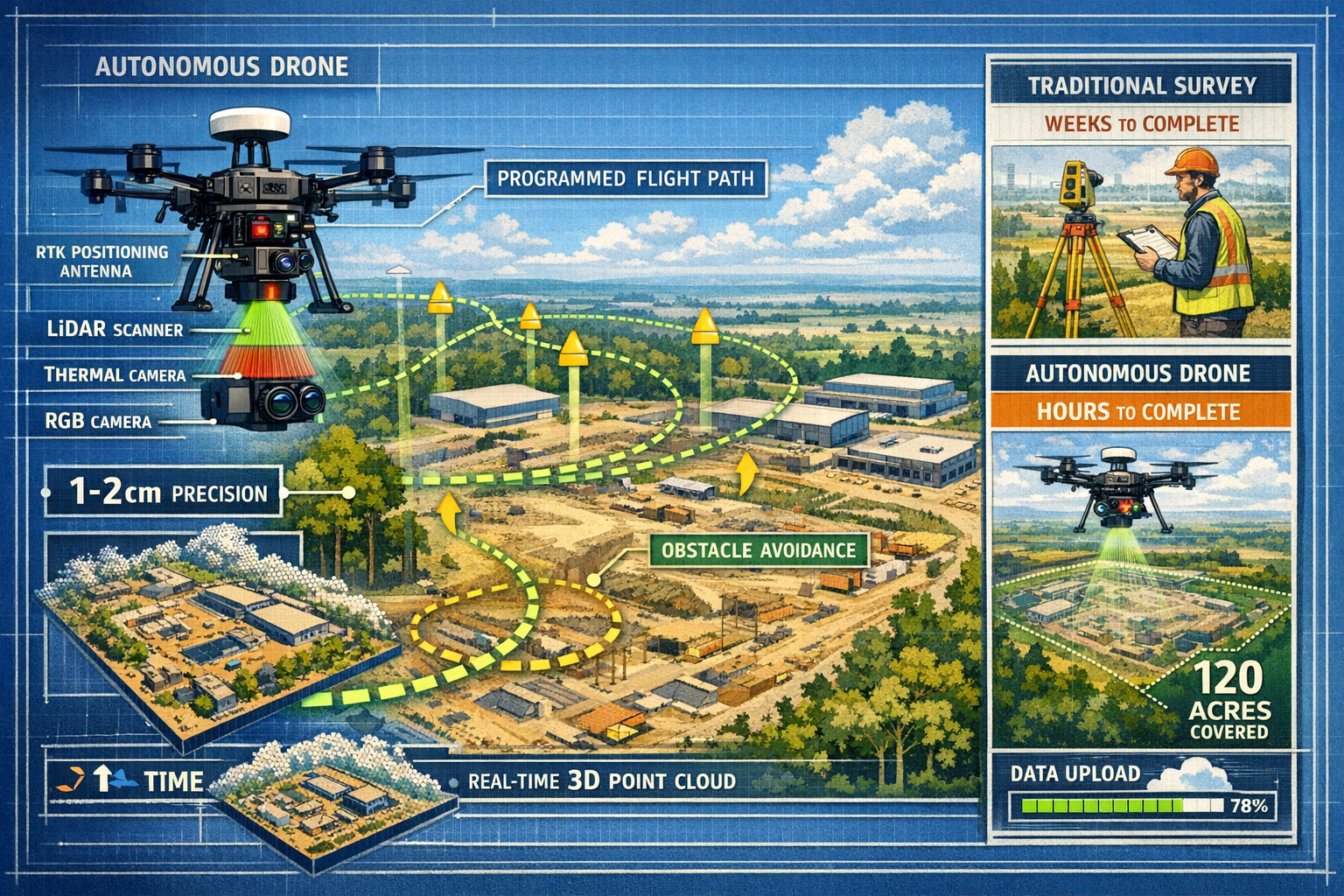
✅ Survey-grade accuracy of 1-2 cm is now standard through RTK/PPK positioning systems, matching or exceeding traditional ground survey precision while covering 120 acres per hour—2,400% faster than manual methods[1][4]
✅ Multi-sensor integration combines LiDAR, thermal imaging, and high-resolution RGB cameras on single platforms, capturing comprehensive roof condition data, terrain mapping, and structural risk indicators simultaneously[4]
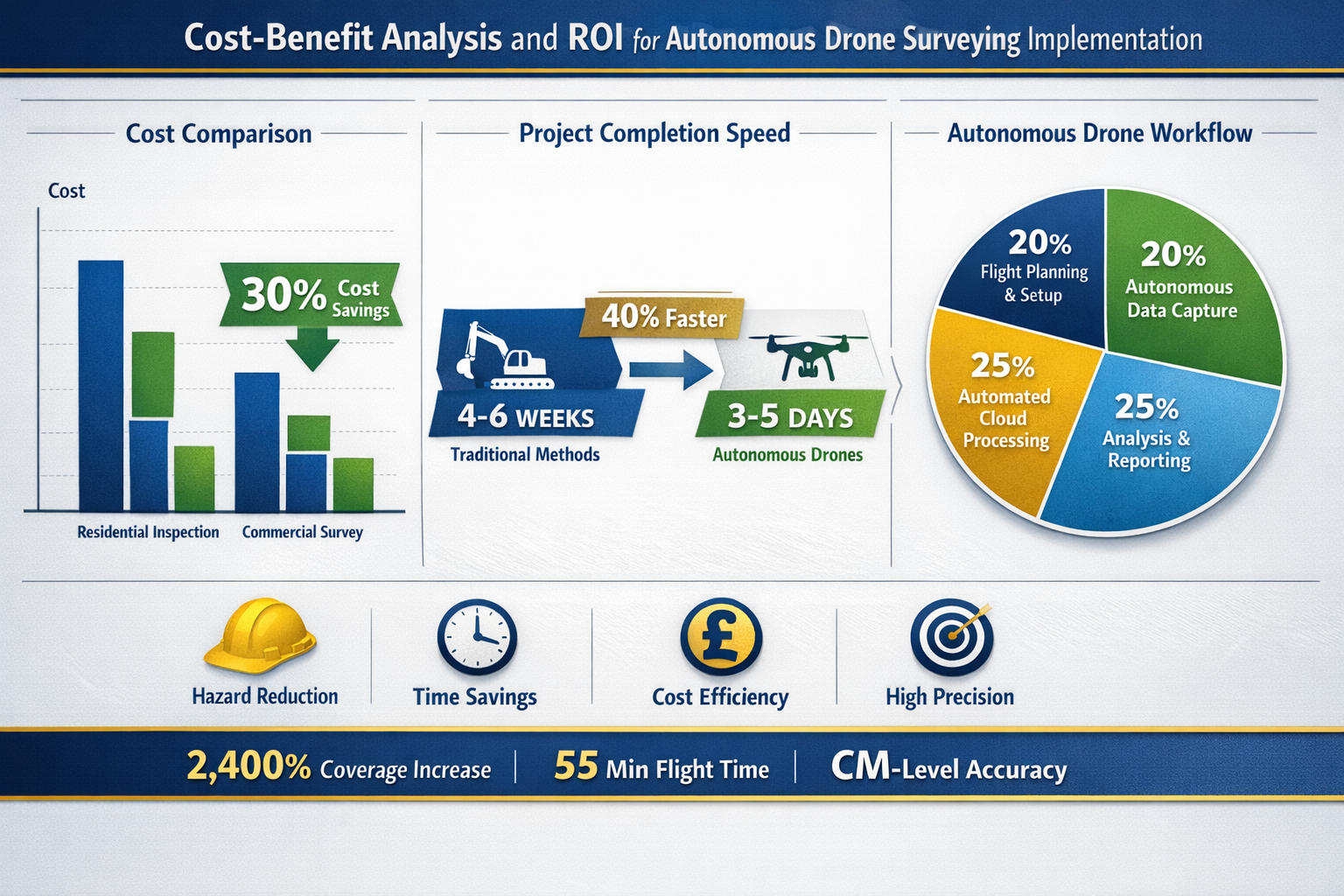
✅ Cost savings reach 30% on major projects while documentation time decreases by 40%, making autonomous surveying economically compelling for residential inspections, commercial developments, and large-scale land assessments[4]
✅ Cloud-based automatic processing eliminates manual post-processing delays, delivering actionable 3D models, orthomosaic maps, and detailed reports within hours instead of weeks[1]
The Evolution to Fully Autonomous Property Surveying Systems
From Manual Piloting to AI-Powered Independence
The journey toward Autonomous Drones in Property Surveying: Capturing Roofs, Terrain, and Risks Without Human Intervention represents years of technological advancement. Traditional drone surveying required skilled pilots to manually navigate each flight, constantly adjusting altitude, camera angles, and flight paths. This human element introduced variability in data quality, limited coverage areas, and created safety concerns when surveying hazardous structures.
The breakthrough came in 2025 when AI-powered autonomous flight systems became commercially viable for professional surveying applications[1]. These systems fundamentally changed the workflow:
Traditional Drone Surveying (Pre-2025):
- Manual flight planning and execution
- Pilot skill directly impacts data quality
- Limited to pilot's line of sight
- Requires constant human monitoring
- Inconsistent overlap and altitude control
Autonomous Surveying (2026):
- AI generates optimal flight paths automatically
- Consistent data quality regardless of operator
- Beyond visual line of sight (BVLOS) capabilities
- Self-monitoring with real-time adjustments
- Uniform overlap ratios and precise altitude maintenance[1]
This evolution particularly benefits building survey professionals who can now deploy autonomous systems to capture comprehensive property data without the limitations of manual piloting expertise.
Real-Time Obstacle Avoidance and Adaptive Routing
Modern autonomous UAVs don't simply follow pre-programmed routes—they think and adapt during flight. Advanced sensor arrays continuously scan the environment, detecting obstacles like trees, power lines, building extensions, and even birds in real-time[1]. When obstacles appear, the drone's AI instantly calculates alternative routes, adjusts altitude, and maintains optimal camera positioning to ensure complete coverage.
This capability proves invaluable when surveying:
🏘️ Complex residential properties with mature trees, satellite dishes, and chimney stacks
🏗️ Active construction sites where conditions change daily
🌳 Undeveloped land parcels with unpredictable terrain and vegetation
⚠️ Hazardous structures requiring safe distance maintenance
The autonomous system's ability to handle unexpected conditions means surveyors can confidently deploy drones on properties they've never visited, trusting the AI to navigate safely and capture complete datasets.
Survey-Grade Positioning Accuracy
Perhaps the most critical advancement enabling professional adoption is centimeter-level positioning accuracy. Modern autonomous drones utilize RTK (Real-Time Kinematic) and PPK (Post-Processed Kinematic) systems that deliver 1-2 cm accuracy—matching or exceeding traditional ground survey standards of 2-5 cm[1][4].
| Measurement Method | Typical Accuracy | Coverage Speed | Weather Dependency |
|---|---|---|---|
| Traditional Ground Survey | 2-5 cm | 5 acres/hour | Low |
| Manual Drone Survey | 5-10 cm | 30 acres/hour | Moderate |
| Autonomous Drone (RTK/PPK) | 1-2 cm | 120 acres/hour | Moderate |
This precision enables autonomous drones to produce legally defensible survey data suitable for property boundary determinations, volumetric calculations for development planning, and detailed building defect assessments.
Multi-Sensor Payloads: Comprehensive Property Intelligence in Single Flights
The Power of Integrated Sensor Systems
The true revolution in Autonomous Drones in Property Surveying: Capturing Roofs, Terrain, and Risks Without Human Intervention lies in multi-sensor integration. Advanced platforms like the DJI Matrice 350 RTK can carry multiple sensors simultaneously, capturing different data types during a single autonomous flight[4].
Standard Multi-Sensor Configuration:
📸 High-Resolution RGB Cameras – Capture detailed visual imagery for orthomosaic map generation and visual inspection
🌡️ Thermal Imaging Sensors – Detect heat signatures indicating insulation failures, moisture intrusion, and electrical issues
📡 LiDAR Scanners – Generate precise 3D point clouds penetrating vegetation to reveal true ground elevation
📏 Multispectral Cameras – Assess vegetation health, drainage patterns, and environmental conditions
This sensor diversity means a single 20-minute autonomous flight can deliver:
- Visual roof condition documentation
- Thermal analysis identifying hidden defects
- Precise 3D terrain models
- Volumetric measurements for earthwork planning
- Vegetation and drainage assessments
For property buyers commissioning comprehensive building surveys, this multi-sensor approach provides unprecedented insight into property condition without requiring multiple site visits or specialist teams.
LiDAR Technology for Terrain and Structural Mapping
LiDAR (Light Detection and Ranging) represents a game-changing sensor for property surveying. Unlike photogrammetry which relies on visible surfaces, LiDAR actively emits laser pulses that penetrate vegetation canopy, revealing ground elevation beneath trees and dense foliage[5].
LiDAR Applications in Property Surveying:
🌲 Undeveloped Land Assessment – Accurate terrain mapping beneath forest cover for development planning
🏚️ Heritage Property Documentation – Detailed structural measurements without physical contact with fragile materials
📐 Precise Volumetric Calculations – Stockpile measurements, cut-and-fill analysis for grading projects
🏔️ Slope and Drainage Analysis – Identifying water flow patterns and erosion risks
The autonomous drone's ability to maintain consistent altitude and flight speed while operating LiDAR sensors ensures uniform point cloud density—typically 100-200 points per square meter—producing highly detailed Digital Elevation Models (DEM) and Digital Surface Models (DSM)[1].
Thermal Imaging for Risk Identification
Thermal sensors on autonomous drones detect temperature variations across building surfaces, revealing hidden defects invisible to standard cameras. This capability transforms roofing surveys by identifying:
⚠️ Moisture Intrusion – Wet insulation appears cooler than dry areas, revealing leak locations
🔥 Insulation Failures – Heat loss patterns indicate inadequate or damaged insulation
⚡ Electrical Issues – Overheating electrical components show as hot spots
🧱 Structural Defects – Thermal bridging reveals construction quality issues
For buyers considering properties, autonomous thermal surveys provide objective evidence of roof condition and energy efficiency—critical factors affecting long-term ownership costs. When combined with visual and LiDAR data, thermal imaging creates a comprehensive risk assessment that would traditionally require multiple specialist inspections.
Extended Flight Times Enable Large Property Coverage
Modern autonomous platforms achieve 55-minute flight times, enabling coverage of extensive properties in single deployments[4]. This endurance proves essential for:
- Large residential estates with multiple buildings and extensive grounds
- Commercial developments requiring comprehensive site documentation
- Agricultural land parcels spanning hundreds of acres
- Infrastructure corridors following roads, railways, or utility easements
The combination of extended flight time and 120 acres per hour coverage means autonomous drones can survey in one day what traditional ground teams would require weeks to complete[4]. For developers evaluating multiple potential sites, this speed advantage dramatically accelerates project timelines.
Applications Across Property Surveying: From Residential Roofs to Development Sites
Residential Property Inspections and Roof Surveys
Homebuyers in 2026 increasingly request autonomous drone surveys as part of their due diligence process. The technology addresses a critical challenge: safely inspecting roofs without scaffolding or dangerous ladder work.
Typical Residential Autonomous Survey Workflow:
1️⃣ Automated Flight Planning – Survey boundaries uploaded; AI generates optimal coverage pattern
2️⃣ Autonomous Data Capture – Drone launches, photographs entire roof from multiple angles, captures thermal data
3️⃣ Cloud Processing – Images automatically upload and process into 3D model and orthomosaic map
4️⃣ Defect Identification – AI flags potential issues: missing tiles, damaged flashing, ponding water
5️⃣ Report Generation – Comprehensive report with measurements, thermal analysis, and risk assessment
This process typically completes within 24-48 hours from deployment to final report—dramatically faster than traditional surveying methods[1]. The detailed documentation proves particularly valuable when buyers discover issues and need to negotiate repairs or price reductions, as discussed in guidance about average price reductions after surveys.
Commercial Development and Construction Monitoring
Autonomous Drones in Property Surveying: Capturing Roofs, Terrain, and Risks Without Human Intervention have become indispensable tools for commercial developers and construction managers. Arizona construction projects using autonomous workflows documented sites 40% faster than legacy methods, with significant cost implications[4].
Construction Phase Applications:
📋 Pre-Construction Site Assessment
- Existing condition documentation
- Topographic mapping for grading plans
- Environmental baseline establishment
- Utility and infrastructure identification
🏗️ Active Construction Monitoring
- Weekly or daily progress documentation
- Deviation detection from architectural plans
- Volumetric tracking of earthwork and materials
- Safety compliance verification
✅ Post-Construction Verification
- As-built documentation
- Quality assurance inspections
- Punch list generation
- Final deliverable creation for owners
The integration with Building Information Modeling (BIM) and digital twin platforms enables real-time comparison between planned designs and actual construction progress[1]. When deviations occur, autonomous surveys quickly identify the extent and location, enabling rapid corrective action before issues compound.
Large-Scale Land and Terrain Surveying
For developers evaluating potential sites or planning large-scale projects, autonomous drone surveying delivers unmatched efficiency. The 2,400% increase in coverage speed compared to ground surveys fundamentally changes project economics[4].
Land Development Survey Deliverables:
🗺️ High-Resolution Orthomosaic Maps – Georeferenced aerial imagery with 1-2 cm/pixel resolution
📊 Digital Elevation Models (DEM) – Precise ground surface elevation data for grading and drainage design
🏔️ Digital Surface Models (DSM) – Complete surface including vegetation and structures for comprehensive planning
📐 Contour Maps – Traditional topographic representations with user-specified contour intervals
📏 Volumetric Calculations – Cut-and-fill analysis, stockpile measurements, capacity assessments
These deliverables enable architects, engineers, and planners to make informed decisions about site suitability, development costs, and design approaches—all before significant capital investment.
Infrastructure and Corridor Surveys
Autonomous drones excel at linear infrastructure surveys where traditional methods prove time-consuming and dangerous. Road corridors, railway lines, utility easements, and pipeline routes benefit from autonomous surveying's speed and safety advantages[1].
The drones' ability to maintain consistent altitude while following complex paths ensures uniform data quality across entire corridors. This consistency proves critical for identifying subtle grade changes, drainage issues, or encroachments that might affect infrastructure performance.
Mining, Quarry, and Stockpile Management
The mining and aggregate industries have rapidly adopted autonomous surveying for regular stockpile measurements and site monitoring. Monthly or even weekly autonomous surveys track inventory volumes with precision previously impossible at reasonable cost[1].
Mining Industry Benefits:
⛏️ Accurate Inventory Management – Precise volumetric measurements of stockpiles and excavations
⚠️ Safety Enhancement – Eliminating human exposure to unstable slopes and active mining areas
📈 Operational Efficiency – Rapid surveys enabling responsive production planning
🌍 Environmental Compliance – Documented proof of reclamation progress and environmental protection measures
The hazardous nature of mining environments makes autonomous operation particularly valuable—drones can survey active quarries, tailings ponds, and unstable slopes without risking surveyor safety.
Economic Impact: Cost Savings and Efficiency Gains
Quantified Cost Reductions on Real Projects
The business case for Autonomous Drones in Property Surveying: Capturing Roofs, Terrain, and Risks Without Human Intervention rests on documented cost savings. Arizona and Nevada construction sites implementing autonomous drone surveying reported 30% cost savings compared to traditional ground survey workflows[4].
Cost Comparison: 50-Acre Commercial Development Site
| Survey Method | Labor Hours | Equipment Cost | Timeline | Total Cost |
|---|---|---|---|---|
| Traditional Ground Survey | 120-160 hours | £3,000-5,000 | 3-4 weeks | £12,000-18,000 |
| Manual Drone Survey | 40-60 hours | £2,000-3,000 | 1-2 weeks | £6,000-9,000 |
| Autonomous Drone Survey | 8-12 hours | £1,500-2,000 | 2-3 days | £4,000-6,000 |
These savings compound across multiple survey phases throughout project lifecycles. For developers managing portfolios of properties, the cumulative cost advantage reaches hundreds of thousands of pounds annually.
Time Efficiency and Project Acceleration
Beyond direct cost savings, autonomous surveying's 40% reduction in documentation time accelerates overall project timelines[4]. In property development, time literally equals money—delayed projects incur carrying costs, lose market opportunities, and tie up capital.
Timeline Impact Example: Residential Development
Traditional workflow (12-week survey and planning phase):
- Week 1-3: Initial ground survey
- Week 4-6: Topographic mapping and processing
- Week 7-9: Design development
- Week 10-12: Revision surveys and verification
Autonomous workflow (7-week survey and planning phase):
- Week 1: Autonomous survey and automated processing
- Week 2-5: Design development with real-time survey updates
- Week 6-7: Verification surveys and final adjustments
The 5-week acceleration enables developers to reach revenue-generating construction phases faster, improving project IRR (Internal Rate of Return) and competitive positioning.
Reduced Risk and Liability Exposure
Safety incidents during traditional surveying create both human and financial costs. Surveyors working on roofs, near excavations, or in active construction zones face injury risks. Autonomous drones eliminate this exposure by keeping humans safely on the ground[1].
Risk Reduction Benefits:
🛡️ Worker Safety – Zero human exposure to heights, unstable structures, or hazardous areas
⚖️ Liability Reduction – Fewer injury claims and associated legal costs
📋 Insurance Savings – Lower premiums reflecting reduced risk profiles
✅ Compliance Assurance – Documented adherence to health and safety regulations
For property management firms conducting regular property inspections, autonomous drones provide comprehensive documentation while minimizing liability concerns associated with inspector access to dangerous areas.
Scalability and Consistency Advantages
Perhaps the most significant long-term economic advantage is scalability. Traditional surveying capacity scales linearly—doubling survey volume requires doubling surveyor teams. Autonomous systems scale more efficiently.
A single surveyor can manage multiple autonomous drones across different sites simultaneously, reviewing automated processing results and focusing expertise on analysis rather than data collection. This leverage effect means surveying firms can handle growing workloads without proportional staff increases.
The consistency of autonomous data collection also reduces rework costs. Manual surveys sometimes require repeat visits when data gaps or quality issues emerge during processing. Autonomous systems' uniform coverage patterns and real-time quality verification virtually eliminate these costly do-overs[1].
Technical Capabilities Enabling Professional Survey Standards
Cloud-Based Automatic Processing Workflows
The transformation from raw aerial imagery to actionable survey deliverables traditionally required skilled technicians spending days in photogrammetry software. Modern autonomous surveying systems automate this bottleneck through cloud-based processing[1].
Automated Processing Workflow:
1️⃣ Automatic Upload – Captured images transfer to cloud platform via cellular or WiFi immediately after landing
2️⃣ AI-Powered Processing – Cloud servers run photogrammetry algorithms, generating point clouds and 3D models
3️⃣ Quality Verification – Automated checks identify gaps, alignment issues, or quality concerns
4️⃣ Deliverable Generation – Orthomosaic maps, DEMs, DSMs, and measurement tools produced automatically
5️⃣ Report Creation – AI-assisted report generation highlights key findings and measurements
This automation reduces turnaround time from weeks to hours. For time-sensitive applications like construction monitoring or property transactions, this speed advantage proves decisive.
Consistent Data Quality Through Standardized Capture
Human pilots naturally introduce variability—different altitude preferences, varying overlap settings, inconsistent camera angles. These variations affect final data quality and processing reliability.
Autonomous systems eliminate this variability by executing standardized capture protocols perfectly every time[1]:
✅ Precise Altitude Maintenance – GPS-controlled height ensures consistent ground sample distance
✅ Optimal Overlap Ratios – Typically 75% forward and 65% side overlap for reliable photogrammetry
✅ Consistent Flight Speed – Maintains optimal speed for camera settings and lighting conditions
✅ Systematic Coverage Patterns – Grid or corridor patterns ensure complete area coverage
The result: predictable, high-quality datasets that process reliably and deliver consistent accuracy across all projects. This reliability enables surveying firms to confidently quote fixed prices and guaranteed turnaround times.
Integration with Professional Survey Workflows
Autonomous drone systems don't exist in isolation—they integrate seamlessly with established professional surveying tools and workflows. Survey-grade GNSS base stations provide ground control points for absolute accuracy. Total stations verify critical measurements. CAD and GIS software import drone-generated data for further analysis[1].
This integration means autonomous drones augment rather than replace traditional surveying expertise. Chartered surveyors leverage autonomous systems to gather comprehensive data rapidly, then apply professional judgment to interpret findings, identify risks, and provide expert recommendations—exactly the value clients seek in Level 3 building surveys.
Emerging Swarm Technology for Large-Scale Projects
The cutting edge of autonomous surveying involves swarm drone technology—multiple autonomous UAVs working cooperatively with minimal human intervention[2]. While still emerging in 2026, early implementations demonstrate compelling advantages:
🤝 Coordinated Coverage – Multiple drones divide survey areas, completing large sites in fraction of single-drone time
🔄 Redundancy and Reliability – If one drone experiences issues, others continue mission without data loss
📊 Multi-Sensor Simultaneous Capture – Different drones carry specialized sensors, capturing all data types in single coordinated flight
⚡ Rapid Response – Swarms can deploy quickly for time-critical applications like disaster assessment or construction emergencies
As swarm technology matures, expect to see autonomous fleets surveying entire housing developments or commercial complexes in hours, delivering comprehensive multi-sensor datasets that would traditionally require weeks of effort.
Regulatory Considerations and Professional Standards
UK CAA Regulations for Autonomous Operations
Operating autonomous drones for commercial surveying in the UK requires compliance with Civil Aviation Authority (CAA) regulations. In 2026, the regulatory framework has evolved to accommodate autonomous operations while maintaining safety standards.
Key Regulatory Requirements:
📜 Operator License – Commercial drone operators must hold appropriate permissions and insurance
🎓 Remote Pilot Competency – Even for autonomous operations, qualified pilots must supervise missions
📍 Airspace Awareness – Autonomous systems must respect restricted zones and altitude limitations
👁️ Beyond Visual Line of Sight (BVLOS) – Advanced permissions required for fully autonomous operations beyond pilot visibility
Surveying firms implementing autonomous systems typically work with specialized aviation consultants to ensure full regulatory compliance. The investment in proper licensing and procedures protects both the firm and clients from legal complications.
Professional Indemnity and Data Accuracy Standards
When autonomous drone surveys inform significant property decisions—purchases, developments, or construction projects—the accuracy and reliability of data becomes legally critical. Professional surveyors using autonomous systems maintain the same duty of care and accuracy standards as traditional methods.
This responsibility means:
✅ Verification Protocols – Critical measurements verified through independent means (ground control points, check surveys)
✅ Professional Indemnity Insurance – Coverage specifically including autonomous drone operations
✅ Quality Assurance Procedures – Documented workflows ensuring consistent accuracy and reliability
✅ Competent Interpretation – Qualified surveyors analyzing autonomous data and providing expert conclusions
The technology may be autonomous, but the professional responsibility remains firmly with qualified surveyors who stake their reputation and credentials on delivered results.
Data Security and Privacy Considerations
Autonomous drones capture detailed imagery of properties and surrounding areas, raising legitimate privacy and security concerns. Professional surveying firms implement robust data management protocols:
🔒 Secure Data Transmission – Encrypted connections for cloud uploads
💾 Controlled Data Storage – Access-limited servers with audit trails
🗑️ Data Retention Policies – Clear schedules for data deletion after project completion
👥 Privacy Compliance – Adherence to GDPR and privacy regulations regarding captured imagery
For residential surveys, surveyors typically notify neighboring properties and limit data capture to the specific property under assessment, respecting privacy while gathering necessary information.
Practical Implementation: Getting Started with Autonomous Surveying
Choosing the Right Autonomous Platform
Not all autonomous drone systems suit property surveying applications equally. When selecting platforms, consider:
Critical Selection Criteria:
🔋 Flight Time – Minimum 30-40 minutes for practical property coverage; 55+ minutes ideal[4]
📡 Positioning Accuracy – RTK or PPK capability for survey-grade precision (1-2 cm)[1][4]
📸 Sensor Compatibility – Multi-sensor payload support for comprehensive data capture
🌧️ Weather Resistance – IP rating for operation in typical UK weather conditions
🔧 Reliability and Support – Established manufacturer with parts availability and technical support
Leading platforms in 2026 include the DJI Matrice 350 RTK for professional applications, offering the 55-minute flight time and multi-sensor capabilities that make comprehensive property surveys practical[4].
Building Internal Capability vs. Outsourcing
Surveying firms and property developers face a strategic decision: develop in-house autonomous surveying capability or outsource to specialist providers.
In-House Capability Advantages:
- Direct control over survey timing and priorities
- Proprietary data remains internal
- Long-term cost savings on high-volume requirements
- Competitive differentiation
Outsourcing Advantages:
- No capital investment in equipment
- Access to latest technology without upgrade costs
- Specialist expertise and regulatory compliance
- Flexibility for variable survey volumes
Many organizations adopt a hybrid approach—maintaining basic autonomous capability for routine work while outsourcing complex or specialized surveys requiring advanced sensors or processing.
Training and Skill Development
Successfully implementing autonomous surveying requires new skill sets combining traditional surveying knowledge with drone technology expertise:
Essential Competencies:
✈️ Drone Operations – Understanding autonomous systems, flight planning, and emergency procedures
📊 Data Processing – Photogrammetry software, point cloud manipulation, and deliverable generation
🔍 Quality Control – Verifying autonomous data accuracy and identifying processing artifacts
⚖️ Regulatory Compliance – CAA regulations, airspace restrictions, and permission requirements
Professional development programs now offer specialized training in autonomous surveying, often leading to recognized certifications that demonstrate competency to clients and insurers.
Integration with Existing Survey Services
For established surveying practices, autonomous drones enhance rather than replace existing service offerings. The technology integrates naturally with traditional building surveys, providing aerial perspectives and comprehensive roof documentation that complement ground-level inspections.
Enhanced Service Offerings:
📋 Comprehensive Building Surveys – Autonomous aerial data combined with traditional internal inspection
🏗️ Development Feasibility Studies – Rapid site assessment with detailed topographic data
📐 Boundary Surveys – Aerial verification supplementing ground-based measurements
🔥 Specialist Risk Assessments – Thermal surveys identifying issues for fire risk assessments and building pathology studies
This integration creates premium service packages that deliver exceptional value, justifying higher fees while reducing surveyor time investment through automation.
Future Developments: What's Next for Autonomous Property Surveying
AI-Powered Defect Detection and Analysis
The next frontier combines autonomous data capture with artificial intelligence analysis. Emerging systems don't just capture imagery—they automatically identify and classify defects, risks, and anomalies[3].
AI Analysis Capabilities:
🔍 Automated Defect Recognition – AI identifies missing roof tiles, damaged flashing, cracks, and deterioration
📊 Condition Scoring – Automated assessment of overall property condition on standardized scales
⚠️ Risk Prioritization – AI ranks identified issues by severity and urgency
💰 Cost Estimation – Machine learning models estimate repair costs based on identified defects
This automation doesn't replace professional surveyor judgment but dramatically accelerates the analysis phase, enabling surveyors to focus expertise on complex issues requiring human interpretation.
Predictive Maintenance and Lifecycle Monitoring
For property managers overseeing building portfolios, autonomous surveying enables predictive maintenance programs. Regular autonomous surveys—quarterly or even monthly—track condition changes over time, identifying deterioration trends before failures occur.
Predictive Maintenance Workflow:
1️⃣ Baseline Survey – Initial comprehensive autonomous survey establishes property condition
2️⃣ Regular Monitoring – Scheduled autonomous surveys capture current condition
3️⃣ Change Detection – AI compares surveys, identifying new defects or deterioration progression
4️⃣ Predictive Modeling – Machine learning forecasts future maintenance requirements
5️⃣ Optimized Planning – Maintenance scheduled proactively before expensive failures occur
This approach transforms property maintenance from reactive crisis management to proactive lifecycle optimization, reducing long-term costs while improving tenant satisfaction.
Integration with Digital Twins and BIM
The convergence of autonomous surveying with Building Information Modeling (BIM) and digital twin technology creates powerful new capabilities[1]. Autonomous surveys provide real-world data that continuously updates digital models, ensuring they reflect actual conditions rather than idealized designs.
Digital Twin Applications:
🏢 Facility Management – Real-time building condition integrated with operational systems
🔄 Renovation Planning – Accurate as-built data enabling precise renovation designs
📈 Asset Valuation – Condition-based valuation models using current survey data
🎯 Performance Optimization – Identifying energy efficiency opportunities through thermal analysis
For property developers and institutional owners, digital twins powered by autonomous surveying data provide unprecedented visibility into asset condition and performance.
Expanded Sensor Capabilities
Sensor technology continues advancing rapidly. Future autonomous surveying platforms will likely incorporate:
🔬 Hyperspectral Imaging – Detecting material composition and chemical signatures
📡 Ground-Penetrating Radar – Revealing subsurface features and utilities
🌊 Acoustic Sensors – Identifying structural vibrations and mechanical issues
💨 Air Quality Monitoring – Assessing environmental conditions around properties
These advanced sensors will enable autonomous drones to gather comprehensive property intelligence far beyond what's visible to human inspectors, identifying hidden issues and providing deeper insights for property decisions.
Conclusion: Embracing the Autonomous Revolution in Property Surveying
Autonomous Drones in Property Surveying: Capturing Roofs, Terrain, and Risks Without Human Intervention represents far more than incremental technological improvement—it's a fundamental transformation of how properties are assessed, documented, and understood. The convergence of AI-powered flight systems, multi-sensor payloads, survey-grade positioning accuracy, and automated cloud processing has created capabilities that seemed impossible just years ago.
The compelling economics—30% cost savings, 40% faster documentation, and 2,400% coverage increases—make autonomous surveying not just technically superior but economically essential for competitive property professionals[4]. Whether you're a homebuyer seeking comprehensive roof inspection, a developer evaluating potential sites, or a surveying firm looking to enhance service offerings, autonomous drone technology delivers unprecedented value.
Actionable Next Steps
For property buyers and owners:
- Request autonomous drone surveys as part of your due diligence process
- Ask surveyors about multi-sensor capabilities (thermal, LiDAR, high-resolution visual)
- Ensure survey providers use RTK/PPK positioning for survey-grade accuracy
- Review sample reports to understand deliverable quality before commissioning
For property developers and investors:
- Evaluate autonomous surveying for site assessment and feasibility studies
- Consider regular autonomous monitoring for active construction projects
- Explore integration with BIM and digital twin platforms
- Calculate ROI including both direct costs and timeline acceleration benefits
For surveying professionals:
- Assess whether in-house capability or specialist partnerships best serve your practice
- Invest in training for autonomous operations and data processing
- Ensure regulatory compliance and appropriate professional indemnity coverage
- Explore enhanced service packages combining autonomous data with traditional expertise
For property managers:
- Implement regular autonomous surveys for portfolio condition monitoring
- Develop predictive maintenance programs using trend analysis
- Use thermal surveys to identify energy efficiency opportunities
- Document property condition for insurance and compliance purposes
The autonomous revolution in property surveying is here, delivering measurable benefits today while promising even greater capabilities tomorrow. Organizations that embrace this technology position themselves at the forefront of an industry transformation, delivering superior client value while building sustainable competitive advantages.
The question is no longer whether to adopt autonomous surveying, but how quickly you can integrate these powerful capabilities into your property assessment and management workflows. The future of property surveying has arrived—and it flies itself.
References
[1] Self Flying Uavs For Survey Mapping Are Redefining Aerial Intelligence – https://www.dronitech.com/self-flying-uavs-for-survey-mapping-are-redefining-aerial-intelligence/
[2] How Technology Is Revolutionizing Land Surveys – https://www.firstchoicesurveying.com/blog/how-technology-is-revolutionizing-land-surveys
[3] Ai Drones For Surveying Enhancing Land Mapping Precision And Efficiency – https://www.arcsurveyors.com/ai-drones-for-surveying-enhancing-land-mapping-precision-and-efficiency/
[4] Uav Construction – https://www.extremeaerialproductions.com/post/uav-construction
[5] roboticstomorrow – https://www.roboticstomorrow.com/article/2026/01/automated-multispectral-terrain-mapping-using-drones-and-robotics/26021/
[6] Webinar The State Of Drone Surveying A Strategic Briefing For 2026 – https://www.aerotas.com/blog/webinar-the-state-of-drone-surveying-a-strategic-briefing-for-2026