The land surveying profession stands at a transformative crossroads in 2026. While traditional surveying methods have served the industry for decades, AI-driven precision in land surveying is fundamentally reshaping how professionals capture, process, and deliver critical spatial data. Imagine surveying hundreds of acres in a single afternoon with accuracy measured in millimeters—what once seemed impossible is now routine practice for early adopters of AI-enhanced surveying technologies.
The integration of artificial intelligence into land surveying workflows represents more than incremental improvement. It signals a paradigm shift in how surveyors approach their work, combining machine learning algorithms, autonomous systems, and real-time data processing to deliver unprecedented accuracy and efficiency. As the architecture, engineering, and construction (AEC) sector navigates digital transformation pressures, understanding how AI-driven precision in land surveying: how 2026 technologies are revolutionizing accuracy and efficiency becomes essential for professionals seeking competitive advantage.
Key Takeaways
✅ AI-powered automation reduces survey data processing time from weeks to hours through machine learning algorithms that analyze massive datasets, identify patterns, and detect anomalies automatically
✅ Autonomous UAVs and robotic systems can survey hundreds of acres in single flights, delivering real-time topographic data with self-calibrating instruments that minimize human error
✅ Predictive analytics enable surveyors to anticipate geological changes, infrastructure risks, and environmental impacts by analyzing historical data combined with current conditions
✅ Integration with BIM and smart city platforms transforms survey data into actionable intelligence for urban planning, construction management, and sustainable development
✅ Despite transformative potential, only 27% of AEC professionals currently use AI, creating significant opportunities for early adopters to gain market leadership[7]
Understanding the Current State of AI Adoption in Land Surveying
The surveying profession's relationship with artificial intelligence in 2026 reflects both cautious optimism and accelerating momentum. Recent industry analysis reveals that only 27% of the architecture, engineering, and construction sector currently uses artificial intelligence[7], indicating substantial room for growth despite clear benefits demonstrated by early adopters.
This relatively modest adoption rate stems from several factors:
- Cultural resistance to changing established workflows
- Investment concerns regarding technology costs and training
- Knowledge gaps about practical AI applications
- Integration challenges with existing surveying equipment and software
However, the surveying profession entered 2026 amid accelerating digital transformation, driven by mounting pressure to deliver faster, more accurate results[6]. This momentum represents a fundamental shift from the status quo, with forward-thinking firms recognizing that AI integration is no longer optional but essential for remaining competitive.
The Business Case for AI Integration
Early adopters report measurable benefits across multiple dimensions:
| Performance Metric | Traditional Methods | AI-Enhanced Methods | Improvement |
|---|---|---|---|
| Data Processing Time | Days to weeks | Hours to days | 70-85% faster |
| Field Survey Duration | Multiple site visits | Single visit or remote | 60% reduction |
| Accuracy Rate | 95-98% | 99.5-99.9% | 2-5% improvement |
| Cost per Acre | Higher labor costs | Reduced field time | 30-50% savings |
These improvements directly impact profitability while simultaneously enhancing service quality—a combination that positions AI-adopting firms for sustained growth in competitive markets.
How AI-Driven Precision in Land Surveying Transforms Data Capture and Processing
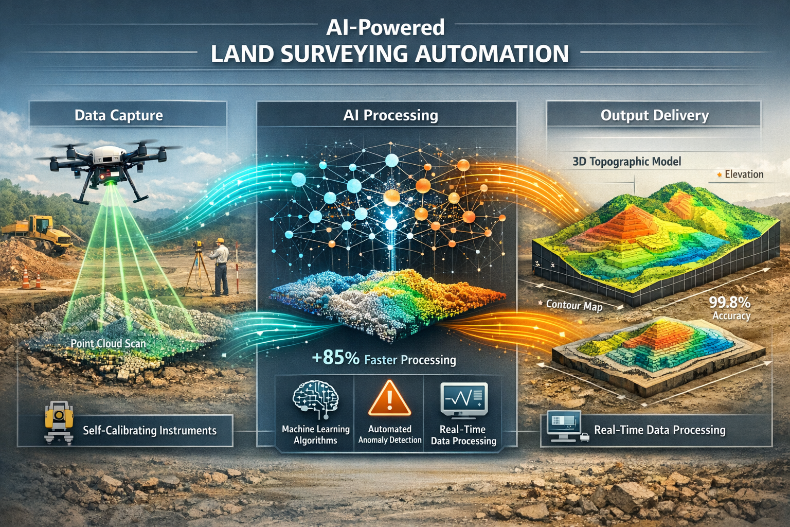
The most immediate impact of AI-driven precision in land surveying manifests in how professionals capture and process spatial data. Traditional surveying workflows required extensive manual data collection, followed by time-consuming office processing to generate deliverable products. AI fundamentally disrupts this model through real-time data capture and automated processing.
Real-Time Data Capture Revolution
AI-enhanced sensors and machine learning models now capture and process survey data simultaneously in the field, dramatically compressing timelines[1]. Where major projects like road construction or land development previously required days or weeks of data collection, AI-powered systems deliver actionable results within hours.
AI-enabled UAVs (unmanned aerial vehicles) exemplify this transformation. These autonomous systems can survey hundreds of acres in a single flight, generating detailed topographic data that processes instantly[1]. For construction companies managing tight deadlines or government agencies overseeing infrastructure projects, this capability translates directly to faster turnaround times and substantial cost savings.
The technology works through sophisticated integration:
- Advanced sensors (LiDAR, photogrammetry, multispectral imaging) capture raw spatial data
- Onboard AI processors apply machine learning models to classify and organize data in real-time
- Cloud connectivity enables immediate data transmission to office systems
- Automated workflows generate preliminary deliverables without manual intervention
Machine Learning Accelerates Analysis
Beyond capture, machine learning algorithms revolutionize how surveyors analyze gathered data. These systems process massive datasets to identify patterns, detect changes, and predict future developments[2]—tasks that would consume weeks of human analyst time.
Consider terrain classification within LiDAR point clouds. AI algorithms distinguish between vegetation, buildings, water features, and bare earth with remarkable precision, dramatically reducing both human error and processing time[1]. AI-based data cleaning tools automatically eliminate inconsistencies, noise, and outliers, providing precise topographic maps ready for planners and engineers.
For professionals conducting measured building surveys, this automation means faster delivery of accurate floor plans and elevation drawings—critical advantages when competing for time-sensitive projects.
Self-Calibrating Instruments Minimize Field Errors
Human error during field measurements has historically represented a significant quality control challenge. AI-enabled survey instruments address this through self-calibration capabilities, continuously monitoring and adjusting their own accuracy parameters[1].
These intelligent total stations, GNSS receivers, and laser scanners:
- Automatically detect environmental factors affecting measurements (temperature, atmospheric pressure, magnetic interference)
- Apply real-time corrections based on machine learning models trained on millions of measurements
- Flag anomalies that require human review before proceeding
- Maintain consistency across multiple operators and equipment units
Machine learning algorithms embedded in these instruments analyze each measurement against expected parameters, automatically correcting anomalies and ensuring consistent quality in mapping results[1]. This capability proves particularly valuable for large projects requiring multiple survey crews working simultaneously.
AI-Driven Precision in Land Surveying: Predictive Analytics and Risk Assessment
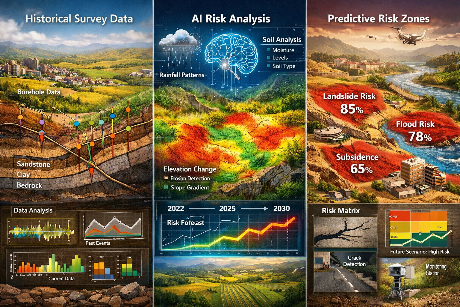
Perhaps the most transformative aspect of AI-driven precision in land surveying lies not in what it measures today, but in what it predicts for tomorrow. Predictive analytics powered by artificial intelligence analyze historical survey data combined with environmental factors to anticipate geological changes, land deformations, and potential risks[1].
Geological and Structural Prediction Capabilities
Traditional surveying provides snapshots of current conditions. AI-enhanced surveying adds temporal depth, enabling professionals to forecast:
- Soil erosion patterns based on topography, vegetation, and rainfall data
- Landslide susceptibility through analysis of slope stability and geological composition
- Ground subsidence risks from groundwater extraction or underground mining
- Coastal erosion trajectories incorporating sea level data and storm patterns
These predictive capabilities transform surveying from reactive documentation to proactive risk management. Infrastructure planners can identify vulnerable areas before committing resources, while property developers gain critical intelligence for site selection and design decisions.
Infrastructure Assessment Automation
The condition of existing infrastructure represents a massive challenge for government agencies and facility managers. In the United States alone, 39% of roads currently exist in poor condition[4], creating urgent demand for rapid, accurate assessment capabilities.
AI tools enable faster and more automated assessment of infrastructure damage, identifying road cracks, deteriorated guard rails, damaged traffic signs, and pavement defects with minimal human intervention[4]. Computer vision algorithms trained on millions of infrastructure images can:
- Classify damage severity according to standardized rating systems
- Prioritize repair needs based on safety and structural criteria
- Estimate repair costs by correlating damage patterns with historical project data
- Track deterioration rates over time through comparative analysis
This automation improves both precision and efficiency in infrastructure development and maintenance projects, enabling agencies to allocate limited budgets more effectively.
Similar to how professionals conduct building materials assessments for property surveys, AI-powered infrastructure assessment provides detailed condition intelligence that informs maintenance strategies and capital planning.
Environmental and Agricultural Monitoring
AI enhances monitoring of critical environmental changes including:
- Deforestation and land use changes through multitemporal satellite and drone imagery analysis
- Desertification progression by tracking vegetation health and soil moisture patterns
- Water resource depletion via analysis of reservoir levels, groundwater indicators, and watershed conditions
In agricultural applications, AI-powered surveys provide unprecedented insights into soil health, crop viability, and irrigation efficiency[1]. Farmers and agricultural consultants leverage these capabilities to:
- Identify nutrient deficiencies across large fields
- Optimize irrigation systems based on topography and drainage patterns
- Predict crop yields through vegetation index analysis
- Plan precision agriculture interventions with centimeter-level accuracy
Flood Risk Modeling and Climate Adaptation
Climate change intensifies the importance of accurate flood risk assessment. AI-driven surveying combines topographic data with hydrological modeling to predict flood scenarios under various rainfall and sea level conditions.
Machine learning models trained on historical flood events can:
- Identify vulnerable areas with greater precision than traditional elevation-only analysis
- Simulate drainage system performance under extreme weather scenarios
- Recommend mitigation strategies based on topographic interventions
- Update risk assessments dynamically as conditions change
This capability proves invaluable for urban planners, insurance underwriters, and emergency management agencies seeking to protect communities from increasing flood risks.
Integration with BIM, Smart Cities, and Future Surveying Technologies
The true power of AI-driven precision in land surveying: how 2026 technologies are revolutionizing accuracy and efficiency emerges when survey data integrates seamlessly with broader digital ecosystems. In 2026, surveying no longer exists as an isolated discipline but as a foundational data layer supporting intelligent infrastructure and urban planning.
Building Information Modeling (BIM) Integration
AI-powered land surveys provide high-resolution data for creating accurate digital models integrated into Building Information Modeling systems[1]. This integration enables:
- As-built verification comparing constructed elements against design intent
- Clash detection identifying conflicts between survey data and proposed designs
- 4D simulation incorporating temporal elements to visualize construction sequencing
- Lifecycle management providing baseline data for facility management and maintenance
For professionals working on Level 3 full building surveys, AI-enhanced data capture accelerates the documentation process while ensuring BIM models reflect actual site conditions with unprecedented accuracy.
The integration workflow typically follows this pattern:
- AI-powered survey equipment captures comprehensive spatial data (point clouds, photogrammetry, measurements)
- Machine learning algorithms automatically classify and organize data by building element type
- BIM software imports classified data, creating intelligent 3D models with embedded attributes
- Collaboration platforms enable stakeholders to access, annotate, and update models in real-time
Smart City Planning and Simulation
AI capabilities extend beyond individual buildings to entire urban environments. AI can simulate the impact of new road networks or housing developments on existing landscapes, evaluating traffic patterns, drainage systems, air quality, and social infrastructure[1].
Urban planners leverage these simulations to:
- Test development scenarios before committing resources to construction
- Optimize transportation networks based on predicted usage patterns
- Plan green infrastructure incorporating stormwater management and urban heat island mitigation
- Ensure equitable access to services and amenities across neighborhoods
These capabilities support sustainable planning by quantifying environmental impacts and identifying optimization opportunities that balance development needs with ecological preservation.
Autonomous Systems and Robotics
Looking beyond 2026, fully autonomous survey systems powered by AI and robotics are expected to dominate the profession within the coming decade[1]. These systems will enable:
- Fully automated fieldwork with minimal human supervision
- Continuous monitoring of critical infrastructure and environmental conditions
- Hazardous environment surveying in locations unsafe for human operators
- 24/7 operations unconstrained by human work schedules
Early examples already exist in 2026, with autonomous ground vehicles conducting routine surveys of highways, railways, and utility corridors. As technology matures, these systems will handle increasingly complex assignments, freeing human surveyors to focus on analysis, interpretation, and client consultation.
Interoperability and Data Ecosystems
AI enhances interoperability between surveying platforms, integrating land survey data with broader smart infrastructure ecosystems[1]. This interoperability enables:
- Unified data standards ensuring survey data works seamlessly across multiple software platforms
- Real-time data sharing between survey teams, designers, contractors, and facility managers
- Automated quality assurance through cross-validation against multiple data sources
- Predictive maintenance by correlating survey data with sensor networks and IoT devices
For organizations managing complex projects requiring statutory considerations and regulatory compliance, this interoperability ensures all stakeholders work from consistent, current spatial information.
Real-World Case Studies: AI Implementation in Practice
Understanding how leading firms implement AI-driven precision in land surveying provides valuable insights for organizations considering similar adoption. While specific company names vary, the patterns of successful implementation share common characteristics.
Case Study 1: Large-Scale Infrastructure Assessment
A regional transportation authority faced the challenge of assessing thousands of miles of roadway to prioritize maintenance budgets. Traditional survey methods would have required years and substantial costs.
AI Solution Implemented:
- Mobile LiDAR systems with AI-powered defect detection
- Machine learning algorithms trained to identify and classify pavement distress
- Automated reporting systems generating prioritized repair lists
Results Achieved:
- Complete network assessment in 6 months versus projected 3+ years
- 40% cost reduction compared to traditional survey methods
- Predictive maintenance scheduling extending pavement life by 15-20%
- Data-driven budget allocation improving resource utilization
Case Study 2: Urban Development Planning
A major city planning department needed comprehensive topographic data for a 5,000-acre development zone to support smart city planning initiatives.
AI Solution Implemented:
- Autonomous UAV fleet surveying with real-time processing
- AI-based terrain classification and feature extraction
- Integration with BIM and urban planning software platforms
Results Achieved:
- Survey completion in 2 weeks versus estimated 3 months using traditional methods
- Centimeter-level accuracy across entire project area
- Immediate availability of data for multiple planning teams
- Simulation capabilities enabling evaluation of 15+ development scenarios
Case Study 3: Environmental Monitoring Program
An environmental agency required ongoing monitoring of coastal erosion across 200 miles of shoreline to support climate adaptation planning.
AI Solution Implemented:
- Quarterly drone surveys with multispectral imaging
- Machine learning models tracking vegetation changes and erosion patterns
- Predictive analytics forecasting erosion rates under various climate scenarios
Results Achieved:
- Early warning system identifying critical erosion areas 18-24 months before traditional methods
- 85% reduction in field survey time and costs
- Comprehensive historical database enabling trend analysis and policy development
- Public communication tools helping communities understand and prepare for changes
Case Study 4: Agricultural Precision Mapping
A large agricultural operation needed detailed soil and drainage mapping across 10,000 acres to optimize irrigation and crop management.
AI Solution Implemented:
- High-resolution topographic surveys with sub-inch vertical accuracy
- AI-powered soil moisture modeling based on terrain analysis
- Integration with precision agriculture equipment and management systems
Results Achieved:
- 30% water usage reduction through optimized irrigation design
- Crop yield improvements of 12-18% in previously underperforming areas
- ROI achievement within 2 growing seasons
- Ongoing monitoring capabilities supporting adaptive management
These case studies demonstrate that AI-driven precision in land surveying delivers measurable value across diverse applications, from infrastructure management to environmental stewardship to agricultural productivity.
Overcoming Implementation Challenges and Barriers
Despite clear benefits, organizations face legitimate challenges when adopting AI-enhanced surveying technologies. Understanding these barriers and mitigation strategies supports successful implementation.
Investment and Cost Considerations
Challenge: AI-enabled surveying equipment and software represent significant capital investments, particularly for smaller firms.
Mitigation Strategies:
- Phased implementation starting with high-ROI applications
- Equipment leasing or subscription models reducing upfront costs
- Partnership arrangements sharing equipment across multiple firms
- ROI analysis demonstrating payback periods through efficiency gains and expanded service capabilities
Similar to considerations when evaluating funding for land development projects, surveying firms should conduct thorough financial analysis weighing costs against projected revenue growth and competitive positioning.
Skills and Training Requirements
Challenge: Existing survey staff may lack expertise in AI technologies, data science, and advanced software platforms.
Mitigation Strategies:
- Structured training programs combining vendor-provided instruction with hands-on practice
- Hiring specialists in data science and geospatial AI to complement traditional surveyors
- Mentorship systems pairing experienced surveyors with technology specialists
- Continuous learning culture encouraging ongoing professional development
The most successful firms recognize that AI doesn't replace surveyors but augments their capabilities, requiring evolution rather than wholesale workforce replacement.
Data Management and Cybersecurity
Challenge: AI-powered surveying generates massive datasets requiring robust storage, processing, and security infrastructure.
Mitigation Strategies:
- Cloud-based platforms providing scalable storage and processing capacity
- Automated backup systems ensuring data protection and disaster recovery
- Cybersecurity protocols protecting sensitive client and project information
- Data governance policies establishing clear standards for data quality, retention, and access
Integration with Legacy Systems
Challenge: Existing workflows, software platforms, and equipment may not readily integrate with AI-enhanced technologies.
Mitigation Strategies:
- API-based integration connecting new AI tools with existing software
- Middleware solutions bridging compatibility gaps between platforms
- Gradual transition maintaining parallel workflows during implementation
- Vendor collaboration ensuring compatibility and support during integration
Quality Assurance and Professional Standards
Challenge: Professional surveyors maintain legal and ethical responsibilities for accuracy regardless of technology used.
Mitigation Strategies:
- Validation protocols comparing AI-generated results against traditional methods during transition
- Human oversight maintaining professional review of AI-generated deliverables
- Documentation standards clearly identifying AI-assisted versus human-verified data
- Professional development ensuring surveyors understand AI capabilities and limitations
Organizations should maintain the same rigorous standards applied to traditional RICS building surveys when delivering AI-enhanced services, ensuring technology enhances rather than compromises professional quality.
The Competitive Landscape: Why Early Adoption Matters
The surveying profession in 2026 faces a defining moment. With only 27% of AEC professionals currently using AI[7], a significant first-mover advantage exists for firms willing to invest in these technologies now.
Market Differentiation Opportunities
Firms offering AI-enhanced surveying services differentiate themselves through:
- Faster turnaround times winning time-sensitive projects
- Superior accuracy reducing risk for clients and downstream users
- Expanded service offerings including predictive analytics and simulation capabilities
- Competitive pricing enabled by efficiency gains
These advantages compound over time as early adopters build expertise, refine workflows, and establish market reputation as technology leaders.
Client Expectations Evolution
Client expectations are rapidly evolving. In 2026, sophisticated clients increasingly expect:
- Real-time data access through cloud platforms and mobile applications
- Integration capabilities with their BIM and project management systems
- Predictive insights beyond basic measurement and mapping
- Visual communication tools including 3D models and simulation animations
Firms unable to meet these expectations risk losing market share to more technologically advanced competitors.
Talent Acquisition and Retention
Technology adoption influences workforce dynamics. Younger professionals entering the surveying field expect to work with modern tools and technologies. Firms offering AI-enhanced workflows:
- Attract top talent seeking innovative work environments
- Retain ambitious professionals through career development opportunities
- Improve job satisfaction by automating tedious tasks and enabling higher-value work
- Build organizational capacity for future technology evolution
Strategic Positioning for Future Technologies
AI adoption in 2026 positions firms for emerging technologies on the near horizon:
- Augmented reality field tools overlaying design information on real-world views
- Quantum computing enabling previously impossible simulation and optimization calculations
- Advanced autonomous systems conducting fully automated surveys
- Blockchain-based data verification and chain-of-custody systems
Organizations building AI competency now develop the foundational knowledge, infrastructure, and culture needed to adopt these future innovations as they mature.
Practical Implementation Roadmap for Surveying Firms
For organizations ready to embrace AI-driven precision in land surveying, a structured implementation approach maximizes success probability while managing risks.
Phase 1: Assessment and Planning (Months 1-3)
Objectives:
- Evaluate current capabilities and identify gaps
- Define strategic goals and success metrics
- Develop business case and secure stakeholder buy-in
Key Activities:
- Capability audit documenting existing equipment, software, skills, and workflows
- Market analysis identifying client needs and competitive landscape
- Technology research evaluating available AI solutions and vendors
- Financial modeling projecting costs, revenue impacts, and ROI timelines
- Stakeholder engagement building consensus among partners, managers, and staff
Phase 2: Pilot Implementation (Months 4-9)
Objectives:
- Test AI technologies on real projects
- Develop operational expertise
- Validate business case assumptions
Key Activities:
- Vendor selection choosing AI platforms and equipment providers
- Initial procurement acquiring pilot-scale technology and software
- Staff training developing core competencies in selected technologies
- Pilot projects applying AI tools to 3-5 representative assignments
- Performance measurement tracking efficiency, accuracy, and client satisfaction metrics
- Workflow refinement optimizing processes based on pilot experience
Phase 3: Scaled Deployment (Months 10-18)
Objectives:
- Expand AI capabilities across service offerings
- Achieve operational efficiency targets
- Establish market differentiation
Key Activities:
- Equipment expansion scaling technology deployment based on demand
- Workforce development training additional staff and hiring specialists as needed
- Service portfolio evolution launching new AI-enabled offerings
- Marketing initiatives communicating capabilities to target clients
- Quality systems establishing standards and protocols for AI-assisted work
- Partnership development collaborating with technology vendors and complementary service providers
Phase 4: Optimization and Innovation (Months 19+)
Objectives:
- Maximize ROI from AI investments
- Maintain competitive advantage through continuous improvement
- Explore emerging technologies and applications
Key Activities:
- Performance optimization refining workflows to maximize efficiency gains
- Advanced applications developing specialized capabilities in predictive analytics, simulation, etc.
- Technology refresh upgrading equipment and software to latest versions
- Thought leadership publishing case studies, presenting at conferences, contributing to industry standards
- Innovation pipeline evaluating and testing emerging technologies
This phased approach allows organizations to manage risk, build competencies progressively, and adapt strategies based on real-world experience.
Regulatory, Professional, and Ethical Considerations

As AI transforms surveying practice, professional and regulatory frameworks continue evolving to address new capabilities and challenges.
Professional Standards Evolution
Professional surveying organizations worldwide are developing guidance addressing AI technologies:
- Competency standards defining required knowledge and skills for AI-assisted surveying
- Quality assurance protocols establishing validation requirements for AI-generated data
- Disclosure requirements mandating transparency about AI use in deliverables
- Continuing education ensuring professionals maintain current knowledge
Surveyors must stay informed about evolving standards in their jurisdictions, ensuring AI adoption complies with professional obligations.
Liability and Insurance Implications
AI introduces new considerations for professional liability:
- Algorithm errors raising questions about responsibility when AI makes mistakes
- Data security breaches creating potential exposure from cloud-based systems
- Scope of service requiring clear definition of what AI can and cannot reliably accomplish
- Documentation requirements establishing audit trails for AI-assisted decisions
Professional indemnity insurance policies may require specific disclosures about AI use. Surveyors should consult with insurance providers and legal advisors to ensure adequate coverage.
Data Privacy and Client Confidentiality
AI-powered surveying often involves cloud processing and data sharing, raising privacy considerations:
- Client consent for cloud storage and third-party processing
- Data sovereignty ensuring compliance with jurisdictional data protection laws
- Retention policies defining how long AI systems retain project data
- Access controls limiting who can view and use sensitive survey information
Firms should develop clear data governance policies addressing these issues, similar to protocols used for sensitive condition survey reports.
Ethical Use of Predictive Analytics
Predictive capabilities raise ethical questions:
- Transparency about confidence levels and limitations of predictions
- Bias mitigation ensuring AI models don't perpetuate historical inequities
- Appropriate use distinguishing between suitable and unsuitable applications for predictive tools
- Professional judgment maintaining human oversight of AI-generated recommendations
Surveyors retain ultimate professional responsibility for work product regardless of technology used, requiring thoughtful consideration of when and how to apply AI capabilities.
Future Trends: What's Next for AI in Land Surveying
While 2026 represents a pivotal year for AI adoption, the technology continues evolving rapidly. Understanding emerging trends helps organizations prepare for the next wave of innovation.
Quantum Computing Applications
Quantum computing promises to revolutionize complex calculations currently beyond practical reach:
- Massive point cloud processing handling billions of data points in seconds
- Complex optimization solving multi-variable problems in urban planning and infrastructure design
- Advanced simulation modeling environmental systems with unprecedented detail
- Pattern recognition identifying subtle relationships in historical survey data
While still emerging, quantum computing may become accessible to surveying applications within 3-5 years.
Advanced Autonomous Systems
Autonomous surveying technology will continue advancing:
- Swarm robotics coordinating multiple autonomous units for rapid large-area coverage
- Underground surveying using autonomous systems in tunnels, mines, and utility networks
- Continuous monitoring deploying permanent autonomous sensors for infrastructure and environmental tracking
- Extreme environment operations conducting surveys in hazardous or inaccessible locations
Enhanced Reality Integration
Augmented and mixed reality will transform how surveyors work:
- Field visualization overlaying design information on real-world views through AR glasses
- Remote collaboration enabling experts to guide field crews in real-time
- Client communication allowing stakeholders to "see" proposed developments in situ
- Training applications providing immersive learning experiences for new surveyors
Blockchain and Distributed Ledger Technology
Blockchain may address data integrity and chain-of-custody challenges:
- Immutable records creating tamper-proof documentation of survey data
- Smart contracts automating payment and deliverable workflows
- Credential verification confirming professional qualifications and equipment calibration
- Data marketplace enabling secure sharing and monetization of survey datasets
Climate Adaptation and Resilience Focus
Environmental pressures will drive surveying applications:
- Sea level rise monitoring tracking coastal changes with millimeter precision
- Carbon sequestration verification measuring vegetation and soil carbon storage
- Renewable energy siting optimizing placement of solar and wind installations
- Ecosystem health assessment monitoring biodiversity and habitat conditions
These trends suggest that AI-driven surveying will become increasingly central to addressing society's most pressing challenges.
Conclusion: Embracing the AI Revolution in Land Surveying
AI-driven precision in land surveying: how 2026 technologies are revolutionizing accuracy and efficiency represents far more than technological novelty. It fundamentally transforms how surveyors serve clients, manage projects, and contribute to society's infrastructure and environmental needs.
The evidence is compelling: AI-enhanced surveying delivers faster turnaround times, superior accuracy, predictive capabilities, and cost efficiencies that traditional methods cannot match. From autonomous UAVs surveying hundreds of acres in single flights to machine learning algorithms predicting geological risks before they manifest, these technologies provide measurable competitive advantages.
Yet with only 27% of AEC professionals currently using AI[7], significant opportunity exists for forward-thinking firms to establish market leadership. The firms that invest in AI capabilities now—building expertise, refining workflows, and demonstrating value to clients—will define the profession's future.
Actionable Next Steps
For surveying professionals and organizations ready to embrace AI-driven precision:
- Conduct a technology assessment evaluating your current capabilities against AI-enhanced alternatives
- Identify high-value applications where AI could deliver immediate ROI in your specific market
- Engage with technology vendors attending demonstrations and requesting pilot opportunities
- Invest in workforce development through training programs and strategic hiring
- Start small but start now implementing pilot projects to build experience and confidence
- Connect with early adopters learning from peers who have successfully navigated AI adoption
- Monitor evolving standards ensuring compliance with professional and regulatory requirements
- Communicate capabilities to clients and prospects, differentiating your services through technology leadership
The surveying profession stands at a crossroads. Those who embrace AI-driven precision will thrive in an increasingly competitive, technology-enabled marketplace. Those who resist risk obsolescence as client expectations and competitive dynamics evolve.
The revolution is underway. The question isn't whether AI will transform land surveying—it already has. The question is whether your organization will lead, follow, or be left behind.
For professionals seeking to understand how modern surveying technologies integrate with comprehensive property assessment, exploring resources on building survey timeframes and comparing Level 2 versus Level 3 surveys provides valuable context for how AI-enhanced capabilities complement traditional surveying services.
The future of land surveying is intelligent, automated, and predictive. The firms that recognize this reality and act decisively will define the profession for decades to come. The time to begin that journey is now.
References
[1] Ai Impact Analysis On Land Survey Equipment Industry – https://www.marketsandmarkets.com/ResearchInsight/ai-impact-analysis-on-land-survey-equipment-industry.asp
[2] The Future Of Land Surveying Technology And Upcoming Trends In 2026 – https://metricop.com/blogs/land-surveying/the-future-of-land-surveying-technology-and-upcoming-trends-in-2026
[3] Mapping The Future Critical Geospatial Trends For 2026 – https://woolpert.com/mapping-the-future-critical-geospatial-trends-for-2026/
[4] How Ai Is Changing The Role Of The Surveyor In Aec – https://www.gim-international.com/content/article/how-ai-is-changing-the-role-of-the-surveyor-in-aec
[5] Top Emerging Land Surveying Technologies Shaping 2026 Drones Ai And Beyond – https://nottinghillsurveyors.com/blog/top-emerging-land-surveying-technologies-shaping-2026-drones-ai-and-beyond
[6] Doubling Down On Digital – https://amerisurv.com/2026/02/01/doubling-down-on-digital/
[7] Architecture Engineering Construction Sector Slow To Adapt Ai Survey Shows – https://www.asce.org/publications-and-news/civil-engineering-source/article/2025/12/18/architecture-engineering-construction-sector-slow-to-adapt-ai-survey-shows