The surveying profession stands at a transformative crossroads in 2026. Imagine processing weeks of complex terrain data in mere minutes, or predicting landslide risks before ground movement begins. This isn't science fiction—it's the reality of AI and Machine Learning in Surveying: Automating Data Analysis and Predicting Risks. As surveying firms face mounting pressure for faster deliverables, workforce shortages, and increasingly complex projects, artificial intelligence has emerged from the experimental phase to become an essential component of modern surveying workflows[6].
Machine learning algorithms now process massive datasets with unprecedented speed and accuracy, identifying patterns invisible to human analysis. These systems classify terrain types, detect structural changes over time, and forecast environmental hazards like flooding and landslides—capabilities that are fundamentally reshaping how spatial professionals approach their work. The integration of AI into surveying represents more than technological advancement; it signals a complete reimagining of data collection, analysis, and risk assessment methodologies.
Key Takeaways
- 🤖 AI systems have reduced post-processing times from weeks to hours or minutes, enabling surveyors to deliver results faster while maintaining accuracy through automated asset detection and anomaly identification[5].
- 📊 Machine learning algorithms excel at pattern recognition across massive datasets, classifying terrain, vegetation, and structures with greater consistency than traditional manual methods[1][3].
- ⚠️ Predictive risk modeling capabilities are emerging, allowing AI systems to forecast environmental hazards including flooding and landslides using historical data and real-time monitoring[1].
- 🚁 Autonomous drone technology has advanced significantly, with AI-powered flight planning, automatic sensor adjustment, and intelligent data capture eliminating much manual intervention[2].
- 👷 Human expertise remains essential, as AI enhances rather than replaces surveyors—professionals still provide critical decision-making, interpretation, legal compliance oversight, and complex field management[1].
The Evolution of AI and Machine Learning in Surveying: Automating Data Analysis and Predicting Risks
From Supplementary Tools to Core Workflow Integration
The surveying industry has witnessed a dramatic transformation in how artificial intelligence functions within daily operations. In 2026, AI systems are no longer peripheral add-ons but are directly embedded into core surveying workflows[2]. This integration means that the moment data is captured—whether from terrestrial laser scanners, aerial drones, or mobile mapping systems—AI algorithms immediately begin their work.
These systems instantly classify terrain types, identify survey markers, flag potential anomalies, and generate preliminary surface models without waiting for human intervention[2]. This real-time processing capability represents a fundamental shift from the traditional workflow where surveyors collected data in the field, returned to the office, and spent days or weeks processing information manually.
The acceleration of digital transformation has been driven by multiple converging pressures. Clients demand faster turnaround times, projects grow more complex, and the industry faces persistent workforce shortages[6]. AI has emerged as the solution that addresses all three challenges simultaneously—delivering speed, handling complexity, and multiplying the productivity of existing personnel.
The Technology Stack Behind Modern AI Surveying
Understanding AI and Machine Learning in Surveying: Automating Data Analysis and Predicting Risks requires examining the technological foundation supporting these capabilities. Modern surveying AI relies on several complementary technologies working in concert:
Neural Networks and Deep Learning: These systems learn to recognize patterns by training on thousands of examples. A neural network trained on building facades can identify structural defects across new properties with remarkable accuracy.
Computer Vision: AI-powered computer vision processes visual data from cameras and sensors, automatically detecting features like property boundaries, utility infrastructure, or vegetation encroachment.
Natural Language Processing: Advanced AI systems can now interpret written survey reports, extract key findings, and even generate preliminary documentation based on field data.
Cloud Computing Infrastructure: The massive computational requirements of AI processing are met through cloud-based platforms that enable collaboration and provide the processing power needed for complex algorithms[6].
Interoperable Data Standards: AI systems work best when data flows seamlessly between different platforms. The surveying industry has increasingly adopted standardized formats that allow AI tools to access and process information regardless of its original source[6].
Similar to how comprehensive building surveys require systematic approaches to property assessment, AI systems require structured data inputs to deliver reliable outputs.
Automating Data Analysis: How Machine Learning Transforms Surveying Workflows
Dramatic Reduction in Post-Processing Time
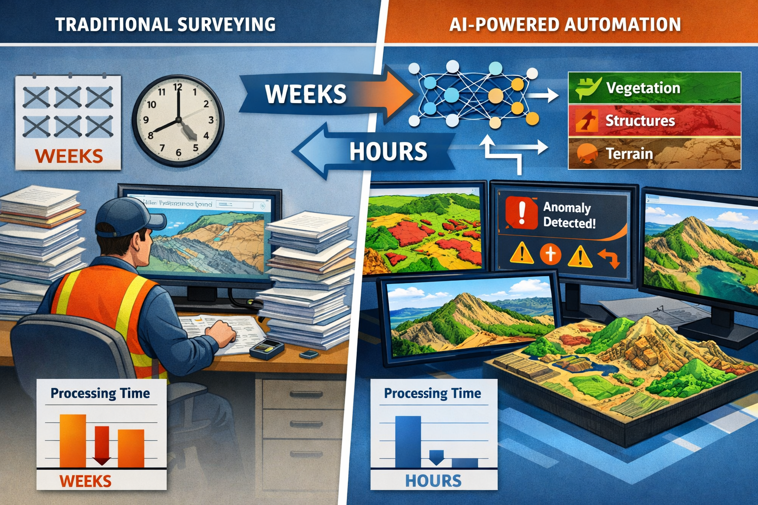
One of the most tangible benefits of AI and Machine Learning in Surveying: Automating Data Analysis and Predicting Risks is the extraordinary reduction in post-processing timelines. Tasks that previously consumed weeks of surveyor time now complete in hours or even minutes[5].
Consider a typical large-scale topographic survey. Traditional workflows required surveyors to:
- Collect raw point cloud data in the field
- Import data into processing software
- Manually classify points (ground, vegetation, buildings, etc.)
- Remove noise and outliers
- Generate surface models
- Create deliverable drawings and reports
Each step demanded skilled attention and significant time investment. With AI-powered workflows, steps 3-5 occur automatically. The system detects assets, identifies defects, and flags anomalies without human intervention[5].
Leading surveying firms have reported transformative results. Haller & Blanchard, for example, has integrated AI-assisted quality checks into their review pipeline, allowing their surveyors to spend more time applying professional expertise rather than processing raw field data[2]. This shift represents a fundamental reallocation of human talent toward higher-value activities.
Automated Classification and Feature Extraction
Machine learning algorithms demonstrate particular strength in classifying terrain, vegetation, and structures from point cloud and imagery data[1][3]. These algorithms process millions of data points simultaneously, applying consistent classification criteria that eliminate the variability inherent in manual classification.
Terrain Classification: AI systems distinguish between ground surfaces, water bodies, paved areas, and various terrain types with accuracy rates exceeding 95% in optimal conditions.
Vegetation Analysis: Algorithms separate vegetation by type and height, identifying individual trees, measuring canopy coverage, and detecting vegetation encroachment on infrastructure.
Structure Recognition: AI can automatically identify buildings, roads, utility poles, fences, and other constructed features, extracting their dimensions and spatial relationships.
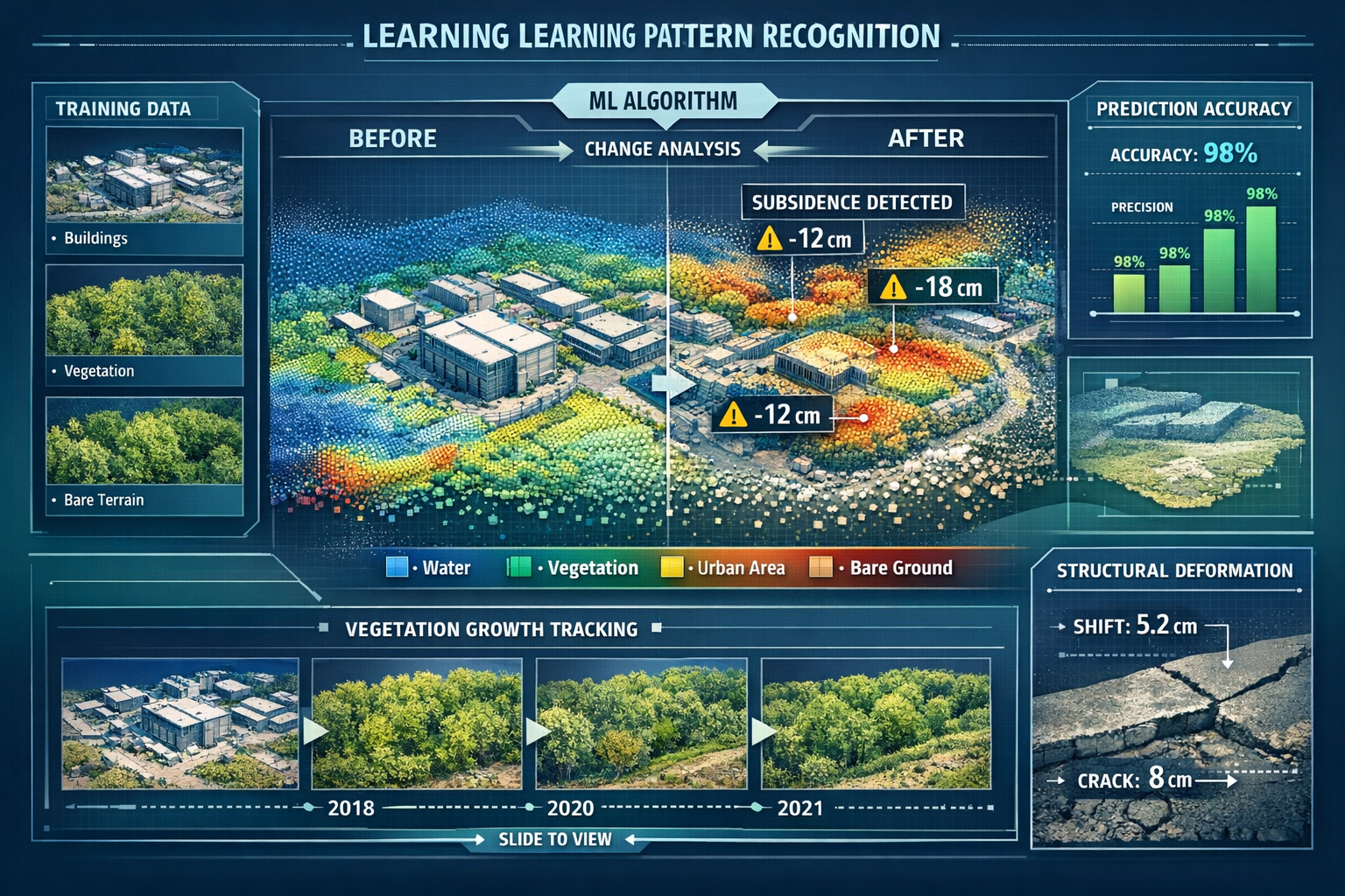
Change Detection: By comparing datasets from different time periods, machine learning algorithms identify structural changes, ground movement, vegetation growth, and other temporal variations[1][3].
This automated classification capability proves especially valuable for large-scale projects. Multi-sensor drones now capture highly detailed information in single flights that previously required multiple site visits, providing clarity and detail for large agricultural, commercial, and development-scale properties[2].
Quality Assurance and Error Detection
AI systems excel at identifying data quality issues that might escape human notice during manual review. These systems can:
- Detect gaps in data coverage where additional field measurements are needed
- Identify outlier points that likely represent measurement errors
- Flag inconsistencies between different data sources
- Verify closure of survey traverses and control networks
- Check compliance with project specifications and industry standards
This automated quality assurance doesn't replace professional judgment but provides an additional layer of verification. Just as Level 3 building surveys require thorough inspection protocols, AI-enhanced surveying workflows incorporate systematic quality checks at every stage.
Pattern Recognition Across Massive Datasets
Perhaps the most powerful capability of machine learning in surveying is its ability to process massive datasets to identify patterns that would be impossible to detect through manual analysis[1][3].
Consider urban infrastructure monitoring. A city might have thousands of buildings, bridges, and roads requiring regular inspection. Traditional approaches sample a small percentage of assets, potentially missing critical issues. AI systems can analyze comprehensive datasets covering entire infrastructure networks, identifying patterns that indicate:
- Systematic deterioration affecting similar structure types
- Geographic clustering of maintenance issues
- Temporal patterns in structural performance
- Correlations between environmental conditions and asset degradation
These insights enable proactive maintenance strategies and more efficient resource allocation. The patterns revealed by machine learning often surprise even experienced professionals, highlighting relationships and trends that weren't apparent through conventional analysis methods.
Predicting Risks: AI-Powered Environmental and Structural Forecasting
Flood Risk Prediction and Hydrological Modeling
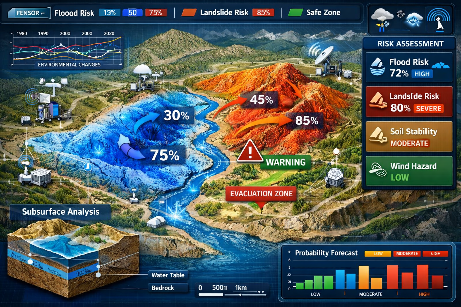
Among the most promising applications of AI and Machine Learning in Surveying: Automating Data Analysis and Predicting Risks is the ability to forecast environmental hazards before they occur. Flood risk prediction represents a particularly valuable use case where AI systems analyze multiple data sources to generate sophisticated risk assessments[1].
Historical Data Integration: Machine learning algorithms process decades of historical flood data, identifying patterns in flood occurrence, extent, and severity. These systems correlate flooding with factors like rainfall intensity, soil saturation, topography, and land use changes.
Real-Time Environmental Monitoring: AI systems integrate real-time data from weather stations, river gauges, soil moisture sensors, and satellite imagery. This continuous monitoring enables dynamic risk assessment that updates as conditions change.
Topographic Analysis: By analyzing detailed terrain models, AI can identify low-lying areas, natural drainage paths, and locations where water naturally accumulates. These systems model how water flows across landscapes under various rainfall scenarios.
Predictive Modeling: Combining historical patterns, current conditions, and topographic analysis, AI systems generate flood probability maps showing which areas face elevated risk under different weather scenarios.
These predictive capabilities prove invaluable for property development, infrastructure planning, and emergency preparedness. Developers can avoid high-risk areas, engineers can design appropriate drainage systems, and emergency managers can pre-position resources where they're most likely needed.
However, it's important to note that these predictive risk tools remain in relatively early development stages. While described as "very promising" for surveying professionals, they require ongoing refinement and validation[1].
Landslide Susceptibility Assessment
Landslides pose significant risks to property, infrastructure, and human safety. Traditional landslide risk assessment relies heavily on geological expertise and historical incident data. AI and machine learning are enhancing these assessments by processing far more comprehensive datasets and identifying subtle precursor indicators[1].
Multi-Factor Analysis: AI systems evaluate numerous factors contributing to landslide risk:
- Slope angle and aspect
- Soil composition and depth
- Vegetation coverage and root structure
- Rainfall patterns and soil saturation
- Seismic activity
- Human activities (excavation, construction, deforestation)
Temporal Monitoring: Machine learning algorithms analyze time-series data from ground-based sensors, satellite radar interferometry, and repeat surveys to detect subtle ground movements that may precede larger failures.
Pattern Recognition: By studying thousands of historical landslides, AI systems learn to recognize the combination of factors that typically precede slope failures. These patterns enable predictive warnings even in areas without previous landslide history.
Risk Mapping: AI generates detailed susceptibility maps showing which slopes face elevated risk under various conditions, enabling better land-use planning and targeted monitoring programs.
For surveyors working in mountainous or geologically unstable regions, these AI-powered risk assessment tools provide critical safety information. Similar to how measured building surveys require precise documentation of existing conditions, landslide risk assessment demands accurate characterization of terrain and subsurface conditions.
Structural Health Monitoring and Deterioration Prediction
Beyond environmental hazards, AI systems increasingly predict structural risks by analyzing how buildings, bridges, and infrastructure deteriorate over time.
Defect Detection: Computer vision algorithms trained on thousands of examples can automatically identify cracks, spalling, corrosion, and other defects in structures. These systems process imagery from drones, mobile mapping vehicles, or handheld cameras, flagging issues for human review.
Deterioration Modeling: Machine learning algorithms analyze how similar structures have deteriorated over time, learning to predict future condition based on current state, age, materials, environmental exposure, and maintenance history.
Predictive Maintenance: By forecasting when structural components are likely to require intervention, AI enables proactive maintenance strategies that address issues before they become critical failures.
Risk Prioritization: When monitoring large portfolios of structures, AI systems can prioritize inspection and maintenance resources toward assets facing the highest risk of failure or those where failure would have the most severe consequences.
These capabilities prove particularly valuable for infrastructure owners managing extensive asset portfolios. Rather than relying on fixed inspection schedules, organizations can implement condition-based maintenance strategies that allocate resources more efficiently.
Subsidence and Ground Movement Detection
Ground subsidence—gradual sinking or settling of the earth's surface—poses risks to buildings, infrastructure, and safety. AI-enhanced surveying techniques have dramatically improved our ability to detect and predict subsidence[1][3].
Satellite Radar Interferometry: AI algorithms process radar satellite data to detect millimeter-scale ground movements over large areas. These systems automatically identify subsidence zones and track movement rates over time.
Point Cloud Comparison: Machine learning algorithms compare point clouds from repeat surveys, automatically detecting vertical changes that indicate subsidence or heave.
Causation Analysis: AI systems correlate ground movement patterns with potential causes like groundwater extraction, mining activity, soil consolidation, or natural geological processes.
Predictive Modeling: By analyzing subsidence patterns and their causes, AI can forecast where future ground movement is likely to occur and estimate its probable magnitude.
For property surveyors, these capabilities provide early warning of subsidence issues that might affect building stability. Just as building surveyors in London must account for various property risks, AI-enhanced subsidence detection adds another layer of due diligence to property assessment.
Autonomous Drone Technology and Multi-Sensor Data Collection
AI-Powered Flight Planning and Execution
The integration of AI and Machine Learning in Surveying: Automating Data Analysis and Predicting Risks has transformed drone-based data collection from a manually intensive process to an increasingly autonomous operation[2].
Predictive Flight Path Planning: Rather than surveyors manually designing flight paths, AI systems now analyze project requirements, terrain characteristics, and desired data quality to automatically generate optimal flight plans. These systems account for:
- Terrain following to maintain consistent ground sampling distance over variable topography
- Obstacle avoidance around trees, structures, and other hazards
- Optimal overlap between images for photogrammetric processing
- Sun angle considerations to minimize shadows and glare
- Wind compensation to maintain image quality and flight efficiency
Automatic Altitude and Angle Adjustment: During flight, AI-powered drones continuously adjust their altitude and camera angles to achieve optimal readings without manual intervention[2]. If the system detects that data quality is degraded in certain areas, it can autonomously adjust flight parameters or trigger additional passes.
Intelligent Sensor Selection: Multi-sensor drones carry various instruments—RGB cameras, multispectral sensors, thermal cameras, LiDAR—and AI systems can automatically select which sensors to activate based on current conditions and data requirements[2].
Real-Time Quality Assessment: Advanced systems perform preliminary data quality checks during flight, identifying gaps or deficiencies while still in the field when additional data collection is straightforward.
This automation dramatically reduces the expertise required for drone operations while improving data quality and collection efficiency. Surveys that previously required experienced drone pilots can now be executed by less specialized personnel, addressing workforce shortage challenges.
Multi-Sensor Integration and Data Fusion
Modern surveying drones often carry multiple sensors simultaneously, capturing different types of data in a single flight. AI plays a crucial role in fusing these diverse data streams into coherent, comprehensive datasets[2].
RGB Imagery: High-resolution color photographs provide visual context and enable photogrammetric 3D reconstruction.
LiDAR Point Clouds: Laser scanning penetrates vegetation and works in low-light conditions, providing accurate elevation data.
Multispectral Imaging: Captures data beyond visible wavelengths, revealing vegetation health, moisture content, and material properties.
Thermal Imaging: Detects temperature variations that indicate moisture intrusion, insulation deficiencies, or equipment malfunctions.
AI algorithms automatically align and integrate these different data types, creating comprehensive datasets that provide far more information than any single sensor could capture. This multi-sensor approach proves especially valuable for large agricultural, commercial, and development-scale properties where comprehensive characterization is essential[2].
Mobile Mapping and Urban 3D Modeling
Beyond aerial drones, AI has accelerated the adoption of mobile mapping technologies for urban environments. Vehicle-mounted or backpack-carried sensor systems capture detailed 3D models of streets, buildings, and infrastructure as they move through urban areas[3].
Rapid 3D Cadastre Creation: Cities increasingly demand 3D cadastres—digital property records that account for vertical development and underground infrastructure. Mobile mapping systems equipped with AI-powered processing can rapidly create these accurate 3D models, addressing the growing need as cities become increasingly vertical[3].
Infrastructure Asset Management: AI systems automatically extract infrastructure assets from mobile mapping data, creating inventories of street signs, utility poles, pavement markings, and other features that require maintenance tracking.
Change Detection: Repeat mobile mapping surveys enable AI systems to automatically identify changes in urban environments—new construction, demolished buildings, altered street configurations—keeping digital records current.
Accessibility Assessment: AI algorithms can analyze mobile mapping data to assess sidewalk conditions, identify accessibility barriers, and plan improvements for pedestrian infrastructure.
Industry Adoption and Implementation Challenges
Current Adoption Rates and Growth Projections
The surveying and broader architecture, engineering, and construction (AEC) sector is actively embracing AI, though adoption rates vary considerably. According to a December 2025 survey, 27% of AEC sector respondents are actively adopting AI, with 94% of those companies planning to increase AI usage in 2026[7].
This represents significant growth from previous years, driven by:
- Competitive pressure as early adopters demonstrate clear advantages in speed and cost-efficiency
- Client expectations for faster deliverables and more sophisticated analysis
- Workforce challenges making productivity-enhancing technologies essential
- Technology maturation as AI tools become more reliable and user-friendly
- Success stories from leading firms demonstrating tangible benefits
However, adoption remains uneven. Larger firms with greater resources have generally moved faster than smaller practices. Geographic variation exists as well, with some regions embracing digital transformation more rapidly than others.
Implementation Barriers and Solutions
Despite growing adoption, organizations face several challenges when implementing AI and Machine Learning in Surveying: Automating Data Analysis and Predicting Risks:
| Challenge | Description | Solutions |
|---|---|---|
| Initial Investment | AI systems require upfront investment in software, hardware, training, and workflow redesign | Phased implementation, cloud-based subscription models, demonstrating ROI through pilot projects |
| Data Quality Requirements | AI systems require high-quality, well-structured input data to function effectively | Implementing data standards, improving collection protocols, data cleaning procedures |
| Skills Gap | Existing staff may lack experience with AI tools and concepts | Training programs, hiring specialists, partnering with technology providers |
| Integration Complexity | Connecting AI tools with existing software and workflows can be technically challenging | Choosing interoperable platforms, working with vendors on integration, adopting industry standards[6] |
| Change Resistance | Some professionals resist workflow changes or fear technology displacement | Emphasizing augmentation rather than replacement, involving staff in implementation, demonstrating benefits |
| Validation Concerns | Questions about AI accuracy and reliability in critical applications | Implementing human review protocols, validating AI outputs, maintaining professional oversight |
Successful implementation typically follows a staged approach. Organizations begin with pilot projects in non-critical applications, build internal expertise, demonstrate value, and gradually expand AI integration across more workflows.
The Human-AI Partnership in Modern Surveying
A critical understanding about AI and Machine Learning in Surveying: Automating Data Analysis and Predicting Risks is that AI enhances rather than replaces human surveyors[1]. The most effective implementations recognize the complementary strengths of AI systems and human professionals.
AI Excels At:
- ✅ Processing massive datasets rapidly
- ✅ Applying consistent classification criteria
- ✅ Detecting subtle patterns across large areas
- ✅ Performing repetitive quality checks
- ✅ Generating preliminary models and reports
Human Surveyors Excel At:
- 👤 Making complex judgment calls
- 👤 Interpreting results in context
- 👤 Ensuring legal and regulatory compliance
- 👤 Managing unexpected field conditions
- 👤 Client communication and relationship management
- 👤 Ethical decision-making
- 👤 Validating AI outputs for accuracy
The most successful surveying firms in 2026 have developed workflows that leverage AI for data processing and pattern recognition while retaining human expertise for interpretation, decision-making, and client service. This partnership model allows surveyors to focus on higher-value activities that require professional judgment while AI handles time-consuming data processing tasks.
Similar to how RICS building surveys require professional expertise to interpret findings and provide recommendations, AI-enhanced surveying still demands qualified professionals to ensure accuracy and appropriate application.
Practical Applications Across Surveying Disciplines
Topographic and Boundary Surveying
AI and machine learning have transformed how surveyors approach traditional topographic and boundary work:
Automated Feature Extraction: AI systems automatically identify and classify topographic features from point clouds and imagery—contours, spot elevations, vegetation boundaries, water features, and structures.
Boundary Determination Support: While legal boundary determination remains a professional responsibility, AI can assist by identifying physical evidence of boundaries in imagery and point cloud data, flagging potential encroachments, and comparing current conditions with historical records.
Terrain Modeling: Machine learning algorithms generate digital terrain models (DTMs) and digital surface models (DSMs) with minimal manual intervention, automatically filtering vegetation and structures to reveal ground surfaces.
Volumetric Calculations: AI-powered systems accurately calculate cut-and-fill volumes for earthwork projects, comparing existing and proposed surfaces while accounting for complex terrain.
Construction and Engineering Surveys
Construction projects benefit significantly from AI-enhanced surveying capabilities:
Progress Monitoring: Drones equipped with AI-powered analysis can automatically compare as-built conditions against design models, identifying deviations and tracking construction progress without manual measurement.
Quality Control: Computer vision systems detect construction defects, verify dimensional accuracy, and ensure compliance with specifications—flagging issues before they become costly problems.
Safety Monitoring: AI analyzes site imagery to identify safety hazards, verify compliance with safety protocols, and monitor high-risk activities.
As-Built Documentation: Automated processing of laser scanning data creates comprehensive as-built models with minimal manual drafting, providing accurate records of completed construction.
Property and Building Surveys
For property surveying applications, AI provides valuable analytical capabilities:
Defect Detection: Computer vision algorithms trained on building pathology can identify common defects—cracks, dampness, structural movement, roof damage—from imagery captured during surveys.
Condition Assessment: Machine learning models can provide preliminary condition ratings for building elements based on visual evidence, supporting surveyors in comprehensive condition assessments.
Measurement Automation: AI systems automatically extract building dimensions, floor areas, and other measurements from laser scan data or photogrammetry, reducing time spent on manual measurement.
Report Generation: Natural language processing can generate preliminary report sections based on survey data, which surveyors then review, refine, and finalize with professional judgment.
These capabilities prove particularly valuable for high-volume work like Level 2 surveys where efficiency gains directly impact profitability while maintaining quality standards.
Infrastructure Asset Management
Organizations managing extensive infrastructure portfolios—transportation departments, utilities, municipalities—are among the most enthusiastic adopters of AI-enhanced surveying:
Asset Inventory: AI automatically identifies and catalogs infrastructure assets from mobile mapping and aerial imagery, creating comprehensive inventories without manual field surveys.
Condition Monitoring: Machine learning models assess asset condition from imagery and sensor data, prioritizing maintenance needs and predicting remaining service life.
Network Analysis: AI systems analyze entire infrastructure networks to identify systematic issues, optimize maintenance strategies, and plan capital improvements.
Performance Prediction: By analyzing historical performance data alongside current condition assessments, AI forecasts future infrastructure performance and helps optimize replacement timing.
Environmental and Natural Resource Surveys
Environmental applications showcase AI's pattern recognition strengths:
Habitat Mapping: AI classifies vegetation types, identifies habitat features, and tracks ecological changes over time from multispectral imagery and LiDAR data.
Erosion Monitoring: Machine learning algorithms detect erosion patterns, predict future erosion risk, and evaluate mitigation effectiveness by comparing repeat surveys.
Wetland Delineation: AI assists in identifying wetland boundaries by analyzing topography, vegetation patterns, and hydrological indicators.
Forest Inventory: Automated tree detection and classification from LiDAR and imagery provides comprehensive forest inventories, measuring individual tree heights, diameters, and species composition.
Future Developments and Emerging Trends
Continued Advancement of Predictive Capabilities
The predictive risk modeling capabilities discussed earlier—flood forecasting, landslide prediction, structural deterioration modeling—remain in relatively early development stages[1]. Ongoing research and increasing availability of training data will significantly enhance these capabilities over the coming years.
Improved Accuracy: As AI systems train on more extensive datasets encompassing diverse conditions and outcomes, their predictive accuracy will improve substantially.
Expanded Risk Types: Current systems focus primarily on environmental and structural risks. Future development will address additional risk categories—fire hazards, seismic vulnerability, climate change impacts, and others.
Integration with IoT Sensors: Real-time data from Internet of Things (IoT) sensor networks will enable continuous risk monitoring and dynamic updates to risk assessments as conditions change.
Probabilistic Forecasting: Rather than binary predictions, advanced systems will provide probabilistic forecasts showing likelihood distributions for various outcomes, enabling more sophisticated risk management strategies.
Enhanced Autonomous Systems
Autonomous surveying systems will continue advancing toward greater independence:
Fully Autonomous Surveys: Future systems may conduct entire surveys with minimal human intervention—planning missions, collecting data, processing results, and generating deliverables with surveyors providing oversight and validation rather than direct control.
Adaptive Data Collection: AI systems will dynamically adjust collection strategies based on real-time quality assessment, environmental conditions, and emerging findings—much as experienced surveyors adapt their approach as they learn more about a site.
Multi-Platform Coordination: Coordinated teams of drones, ground robots, and stationary sensors will work together under AI coordination, optimizing data collection across complex sites.
Integration with Digital Twins and Smart Cities
The convergence of AI-enhanced surveying with digital twin technology and smart city initiatives represents a significant emerging trend:
Continuous Updates: Rather than periodic surveys creating static snapshots, continuous data collection from multiple sources will keep digital twins perpetually current.
Predictive Simulation: Digital twins enhanced with AI will simulate future scenarios—traffic patterns, environmental changes, infrastructure deterioration—enabling proactive planning.
Automated Change Detection: AI systems will continuously monitor for changes in physical environments, automatically updating digital records and flagging significant alterations.
Democratization of Advanced Capabilities
As AI technology matures, capabilities once available only to large firms with specialized expertise are becoming accessible to smaller organizations:
Cloud-Based Processing: Cloud platforms provide powerful AI processing capabilities without requiring local hardware investment.
User-Friendly Interfaces: AI tools increasingly feature intuitive interfaces that don't require data science expertise to operate effectively.
Subscription Models: Software-as-a-service pricing makes advanced AI tools financially accessible to smaller firms.
Pre-Trained Models: Rather than training AI systems from scratch, surveyors can leverage pre-trained models developed by technology providers and adapted to specific applications.
This democratization will accelerate industry-wide adoption and level the competitive playing field between large and small firms.
Best Practices for Implementing AI in Surveying Operations
Starting with Clear Objectives
Successful AI implementation begins with clearly defined objectives. Organizations should identify specific pain points or opportunities where AI can deliver measurable value:
- Reduce post-processing time for specific survey types
- Improve quality control by catching errors earlier
- Expand service offerings to include predictive risk assessment
- Increase surveyor productivity by automating routine tasks
- Enhance competitive positioning through faster turnaround times
Clear objectives enable focused implementation efforts and provide metrics for measuring success.
Ensuring Data Quality and Standardization
AI systems are only as good as the data they process. Organizations implementing AI should:
✓ Establish data collection standards ensuring consistency across projects and personnel
✓ Implement quality control procedures for field data before AI processing
✓ Adopt industry-standard formats enabling interoperability between systems[6]
✓ Maintain organized data archives that AI systems can access for training and historical analysis
✓ Document metadata providing context that helps AI systems interpret data correctly
Maintaining Human Oversight and Validation
While AI automates many tasks, professional oversight remains essential:
🔍 Review AI outputs for accuracy and reasonableness before delivering to clients
🔍 Establish validation protocols for critical applications where errors have serious consequences
🔍 Maintain professional liability by ensuring qualified surveyors verify AI-generated results
🔍 Document AI usage in reports and deliverables, clearly indicating which analyses involved AI processing
🔍 Develop exception handling procedures for situations where AI systems produce questionable results
This oversight ensures that AI enhances professional work rather than introducing new risks.
Investing in Training and Skills Development
Successful AI adoption requires workforce development:
- Provide training on AI tools and concepts for existing staff
- Hire specialists with AI and data science expertise to lead implementation
- Encourage experimentation with new AI capabilities in low-risk applications
- Foster a learning culture that embraces technological change
- Partner with technology providers for training and technical support
Organizations that invest in their people alongside technology investment achieve better implementation outcomes.
Choosing the Right Technology Partners
The AI surveying technology landscape includes numerous vendors offering various solutions. When selecting technology partners, consider:
Integration Capabilities: Does the solution work with your existing software and workflows, or does it require complete replacement of current systems?
Industry Specificity: Is the AI system designed specifically for surveying applications, or is it a general-purpose tool requiring extensive customization?
Support and Training: What level of implementation support, training, and ongoing technical assistance does the vendor provide?
Scalability: Can the solution grow with your organization as adoption expands?
Track Record: Does the vendor have proven success with similar organizations in the surveying industry?
Data Security: How does the vendor protect sensitive survey data, especially when processing occurs in cloud environments?
Careful vendor selection significantly influences implementation success and long-term satisfaction.
Regulatory, Legal, and Ethical Considerations
Professional Standards and Liability
As AI becomes integral to surveying workflows, professional organizations and regulatory bodies are developing guidance on appropriate use:
Professional Responsibility: Surveyors remain professionally responsible for work delivered to clients, regardless of AI involvement in its production. This means AI-generated outputs require professional review and validation.
Standards of Practice: Professional organizations are developing standards addressing AI use, including requirements for validation, documentation, and disclosure.
Liability Questions: Legal frameworks are evolving to address liability when AI systems contribute to errors. Current consensus holds that professionals using AI tools remain liable for their outputs.
Competency Requirements: Surveyors using AI tools must understand their capabilities, limitations, and appropriate applications—requiring ongoing education as technology evolves.
Data Privacy and Security
AI systems often process sensitive property and infrastructure data, raising privacy and security concerns:
Client Confidentiality: Survey data often contains confidential information about property conditions, boundaries, and valuations. AI processing workflows must maintain appropriate confidentiality protections.
Data Storage and Processing: When using cloud-based AI services, organizations must ensure data is stored and processed in compliance with applicable privacy regulations.
Cybersecurity: AI systems connected to networks may create new cybersecurity vulnerabilities requiring appropriate protective measures.
Data Ownership: Contracts should clearly specify who owns data processed by AI systems and what rights technology providers have to use survey data for training or other purposes.
Ethical AI Use in Surveying
Beyond legal requirements, ethical considerations guide responsible AI implementation:
Transparency: Clients and stakeholders should understand when AI has been used in survey work and how it influenced results.
Bias Awareness: AI systems can perpetuate or amplify biases present in training data. Surveyors should be aware of potential biases and take steps to mitigate them.
Appropriate Application: AI should be applied to tasks where it demonstrably improves outcomes, not simply because the technology is available.
Human Dignity: Automation should enhance rather than devalue human expertise, maintaining respect for professional knowledge and judgment.
Conclusion: Embracing the AI-Enhanced Future of Surveying
The integration of AI and Machine Learning in Surveying: Automating Data Analysis and Predicting Risks represents far more than incremental technological improvement—it signals a fundamental transformation in how spatial professionals approach their work. In 2026, AI has moved from experimental curiosity to essential tool, embedded in core workflows and delivering tangible benefits in processing speed, analytical depth, and predictive capability[2][5].
The evidence is compelling: post-processing times reduced from weeks to hours, pattern recognition across datasets too massive for manual analysis, and emerging capabilities to forecast environmental and structural risks before they materialize[1][5]. These advances address the surveying profession's most pressing challenges—client demands for faster deliverables, workforce shortages requiring productivity multiplication, and increasingly complex projects demanding sophisticated analysis[6].
Yet the future of surveying is not one where algorithms replace professionals. Instead, the most successful organizations in 2026 have developed human-AI partnerships that leverage the complementary strengths of both. AI excels at rapid data processing, consistent classification, and pattern detection across massive datasets. Human surveyors provide irreplaceable judgment, contextual interpretation, legal compliance oversight, and client relationship management[1].
Actionable Next Steps for Surveying Professionals
Whether you're a surveying firm principal, project manager, or field surveyor, concrete steps can position you to benefit from AI integration:
1. Assess Current Workflows: Identify specific tasks in your workflows that consume excessive time, introduce errors, or limit capacity. These pain points represent prime opportunities for AI enhancement.
2. Start with Pilot Projects: Rather than comprehensive transformation, begin with focused pilot projects in non-critical applications. Learn from these experiences before expanding AI integration.
3. Invest in Education: Dedicate time to understanding AI capabilities, limitations, and appropriate applications. Attend training, conferences, and webinars focused on AI in surveying.
4. Evaluate Technology Options: Research available AI tools relevant to your practice areas. Request demonstrations, speak with current users, and assess integration with existing systems.
5. Develop Data Standards: Implement consistent data collection and management practices that will enable effective AI processing.
6. Build Strategic Partnerships: Connect with technology providers, consultants, and other surveying firms to learn from their AI implementation experiences.
7. Communicate with Clients: Discuss AI capabilities with clients, explaining how these tools can deliver faster, more comprehensive results while maintaining professional oversight.
The surveying profession stands at a pivotal moment. Those who thoughtfully embrace AI and Machine Learning in Surveying: Automating Data Analysis and Predicting Risks will find themselves well-positioned for the increasingly digital future. Those who resist risk falling behind as client expectations, competitive pressures, and technological capabilities continue advancing.
The question is no longer whether AI will transform surveying—that transformation is already underway. The relevant question is how each professional and organization will adapt to maximize the opportunities while maintaining the professional standards and human expertise that remain essential to excellent surveying practice.
For surveying firms seeking to understand how AI can enhance their specific services—whether building surveys, property valuations, or infrastructure assessments—the time to explore these capabilities is now. The future of surveying is being written in 2026, and it's a future where human expertise and artificial intelligence work together to deliver unprecedented value to clients and society.
References
[1] The Future Of Land Surveying Technology And Upcoming Trends In 2026 – https://metricop.com/blogs/land-surveying/the-future-of-land-surveying-technology-and-upcoming-trends-in-2026
[2] Future Land Surveying 2026 – https://haller-blanchard.com/future-land-surveying-2026/
[3] Land Surveying Propelled Into The Future With Ai And Drones – https://resource-erectors.com/land-surveying-propelled-into-the-future-with-ai-and-drones/
[5] How Is Ai And Machine Learning Transforming Data Collection Operations In 2026 – https://flyguys.com/how-is-ai-and-machine-learning-transforming-data-collection-operations-in-2026/
[6] Doubling Down On Digital – https://amerisurv.com/2026/02/01/doubling-down-on-digital/
[7] Architecture Engineering Construction Sector Slow To Adapt Ai Survey Shows – https://www.asce.org/publications-and-news/civil-engineering-source/article/2025/12/18/architecture-engineering-construction-sector-slow-to-adapt-ai-survey-shows