The construction site fell silent as engineers reviewed the latest ground movement data. Traditional methods would have taken weeks to process the measurements and identify potential settlement issues. Instead, machine learning algorithms flagged anomalies within hours, predicting a critical subsidence risk that could have compromised the entire structure. This scenario, once science fiction, represents the new reality of property surveying in 2026.
AI and Machine Learning in Property Surveying: Predicting Risks and Automating Data Analysis for 2026 has transformed how professionals assess properties, identify hazards, and deliver actionable insights. From forecasting flood risks to detecting structural changes invisible to the human eye, these technologies are revolutionizing an industry built on precision and safety. The surveying profession now stands at the intersection of traditional expertise and cutting-edge technology, where vast datasets unlock predictive capabilities that save lives, reduce costs, and accelerate project timelines.
Key Takeaways
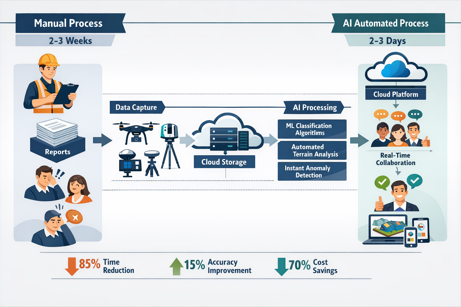
✅ Machine learning algorithms can automatically classify terrain, analyze land-use patterns, and eliminate manual repetitive workflows, accelerating data analysis by up to 85%
✅ Predictive models forecast soil movement, building settlement, and environmental risks like floods or landslides, enabling proactive risk management rather than reactive assessment
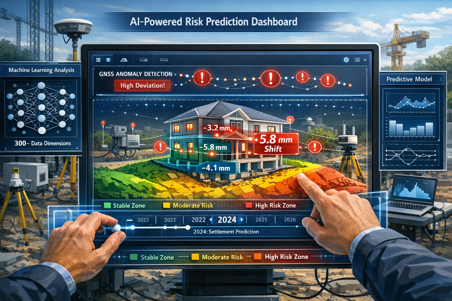
✅ Real-time anomaly detection in surveying measurements improves data quality by instantly identifying outliers in GNSS observations and leveling data
✅ AI-powered platforms analyze 300+ data dimensions simultaneously, providing hyper-local market intelligence and institutional-grade insights for property risk assessment
✅ Over 90% of leading real estate companies now consider AI a strategic priority, with valuation accuracy improvements of up to 15% demonstrated in recent studies[1]
Understanding AI and Machine Learning in Property Surveying: Predicting Risks and Automating Data Analysis for 2026
The surveying profession is experiencing unprecedented transformation in 2026. Traditional methods that relied heavily on manual data collection, processing, and interpretation are giving way to intelligent systems capable of processing massive datasets in real-time. This shift addresses critical industry challenges: workforce shortages, increasing client demands for faster turnaround times, and the complexity of modern construction projects requiring unprecedented accuracy.
The Digital Transformation Landscape
The surveying profession faces mounting pressure to deliver faster, more accurate results while managing workforce shortages and evolving client expectations. AI, cloud-based collaboration platforms, and interoperable hardware/software are fundamentally reshaping how spatial data is captured, processed, and shared[5]. This transformation extends beyond simple digitization—it represents a complete reimagining of surveying workflows.
Reality capture has become integral to project management workflows, with surveyors now documenting conditions, visually tracking progress, and collaborating on solutions in real-time. Enhanced by AI, machine learning, and cloud-based platforms, these capabilities enable stakeholders to make informed decisions based on current, accurate spatial data[5].
How AI Processes Surveying Data
Modern AI systems in property surveying operate through several sophisticated mechanisms:
🔍 Pattern Recognition: Machine learning models identify patterns across historical datasets, learning to recognize indicators of structural issues, terrain instability, or environmental risks that might escape human observation.
📊 Multi-Dimensional Analysis: AI algorithms simultaneously evaluate hundreds of variables—from soil composition and moisture levels to historical weather patterns and nearby construction activity—creating comprehensive risk profiles.
⚡ Real-Time Processing: Unlike traditional methods requiring days or weeks for analysis, AI systems process incoming data streams continuously, flagging anomalies and updating risk assessments as conditions change.
🎯 Predictive Modeling: By analyzing historical patterns and current conditions, machine learning models forecast future scenarios, from settlement rates to flood probability under various climate conditions.
When conducting a Level 3 building survey, surveyors now leverage these AI capabilities to provide deeper insights than ever before, identifying potential issues before they become critical problems.
Predicting Environmental and Structural Risks with Machine Learning
The ability to forecast risks before they materialize represents one of the most significant advantages of AI and Machine Learning in Property Surveying: Predicting Risks and Automating Data Analysis for 2026. These predictive capabilities extend across multiple risk categories, each with profound implications for property safety and investment decisions.
Soil Movement and Settlement Forecasting
Predictive ML models can forecast soil movement and building settlement, providing proactive risk identification rather than reactive assessment[3]. This capability proves particularly valuable in areas with clay soils, underground water sources, or recent construction activity that might destabilize foundations.
Settlement prediction models analyze:
- Historical ground movement data from satellite imagery
- Soil composition and geological surveys
- Moisture content variations across seasons
- Nearby excavation or construction activities
- Underground water table fluctuations
- Building load distribution patterns
These models generate probability distributions for settlement rates, identifying structures at risk months or years before visible damage occurs. For properties requiring building defects surveys, this predictive capability enables early intervention and cost-effective remediation.
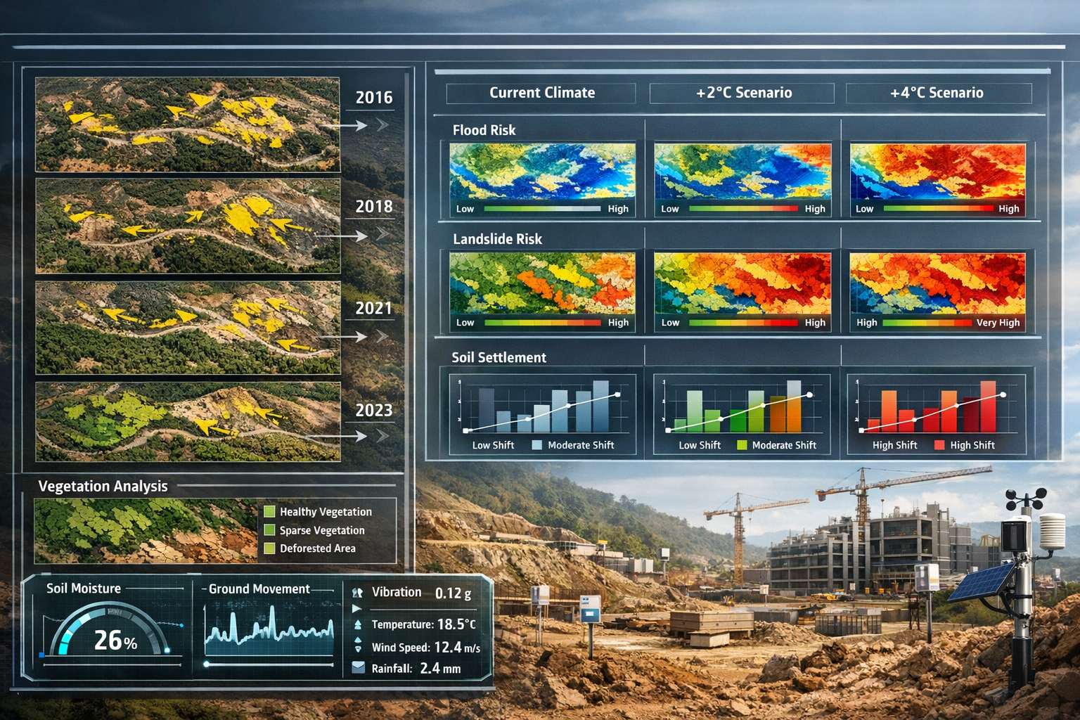
Flood and Landslide Risk Assessment
Machine learning algorithms excel at processing vast datasets to detect changes and forecast environmental hazards. Flood risk prediction combines multiple data sources:
| Data Source | AI Application | Risk Insight |
|---|---|---|
| Historical rainfall patterns | Trend analysis and seasonal forecasting | Probability of flooding events |
| Topographical surveys | Terrain modeling and water flow simulation | Vulnerable areas and drainage paths |
| Soil permeability data | Absorption rate calculations | Surface water accumulation zones |
| Climate projections | Scenario modeling under different conditions | Long-term risk evolution |
| Infrastructure changes | Impact assessment of development | Altered drainage patterns |
Landslide susceptibility assessment follows similar principles, with AI models analyzing slope angles, soil composition, vegetation cover, rainfall intensity, and historical instability indicators. These systems provide probabilistic risk scores at granular geographic levels, moving beyond broad regional assessments to property-specific evaluations.
For properties in areas prone to subsidence, these predictive capabilities prove invaluable for insurance underwriting, property valuations, and construction planning.
Real-Time Anomaly Detection in Measurements
AI can instantly identify outliers in GNSS observations and leveling data, improving data quality and reducing errors in surveying measurements[3]. This real-time quality control represents a significant advancement over traditional methods where errors might not be discovered until final data processing.
Anomaly detection systems monitor:
- GNSS signal quality: Identifying multipath interference, atmospheric disturbances, or equipment malfunctions
- Leveling consistency: Flagging measurements that deviate from expected patterns based on surrounding data points
- Temporal variations: Detecting unusual changes between survey periods that might indicate equipment drift or environmental factors
- Spatial correlations: Identifying measurements inconsistent with neighboring points, suggesting localized issues
These systems learn from vast datasets of "normal" survey conditions, developing sophisticated understanding of acceptable variation ranges. When measurements fall outside these parameters, immediate alerts enable surveyors to investigate and recalibrate before proceeding, ensuring data integrity throughout the surveying process.
Structural Health Monitoring
Beyond environmental risks, AI systems continuously monitor structural integrity through sensor networks deployed on buildings and infrastructure. Vibration analysis, strain measurements, and thermal imaging data feed into machine learning models that detect subtle changes indicating:
- Developing cracks or material fatigue
- Foundation settlement or differential movement
- Water ingress or moisture accumulation
- Structural load redistribution
- Material degradation over time
These systems provide early warning of issues requiring attention during building materials assessments, enabling proactive maintenance rather than emergency repairs.
Automating Data Analysis and Streamlining Surveying Workflows
The automation capabilities of AI and Machine Learning in Property Surveying: Predicting Risks and Automating Data Analysis for 2026 extend far beyond risk prediction, fundamentally transforming day-to-day surveying operations and delivering unprecedented efficiency gains.
Automated Terrain Classification and Land-Use Analysis
ML models can automatically classify terrain and land-use patterns, eliminating manual repetitive workflows and accelerating data analysis[3]. Where surveyors once spent days manually categorizing land features from aerial imagery or survey data, machine learning algorithms now complete these tasks in hours or minutes.
Terrain classification systems identify and categorize:
- Vegetation types: Distinguishing between grassland, woodland, agricultural crops, and urban landscaping
- Built structures: Recognizing buildings, roads, bridges, and other infrastructure
- Water features: Identifying rivers, ponds, wetlands, and drainage systems
- Topographical features: Classifying slopes, valleys, ridges, and elevation changes
- Surface materials: Distinguishing between concrete, asphalt, soil, gravel, and other surfaces
These automated classifications feed directly into planning applications, environmental impact assessments, and development feasibility studies. The consistency and speed of AI-driven classification eliminates human variability and enables surveyors to focus on interpretation and strategic recommendations rather than manual data categorization.
Digital Twin Technology and As-Built Documentation
Platforms like Matterport's Property Intelligence suite use generative AI to automate property surveying and as-built documentation, accelerating project timelines by providing instantly editable, data-rich digital replicas of physical assets[1]. Digital twins represent one of the most transformative applications of AI in surveying.
These virtual replicas offer:
📐 Precise Spatial Measurements: Automated extraction of dimensions, areas, and volumes from 3D scans with millimeter accuracy
🔄 Real-Time Updates: Continuous synchronization between physical construction progress and digital models, enabling stakeholders to track changes instantly
🎨 Visual Documentation: Photorealistic representations that eliminate ambiguity in communications between architects, engineers, contractors, and clients
📊 Data Integration: Embedding of metadata, specifications, material information, and maintenance schedules directly within the 3D environment
🔍 Virtual Inspections: Remote assessment capabilities that reduce site visits while maintaining comprehensive oversight
For professionals conducting construction and condition surveys, digital twins provide unprecedented documentation quality and accessibility, streamlining reporting and collaboration.
Cloud-Based Collaboration and Spatial Data as Common Language
AI and cloud-based platforms are enabling spatial data to serve as a common visual language that helps all stakeholders align efforts across projects and reduce misunderstandings[5]. This transformation addresses one of the construction industry's persistent challenges: communication gaps between diverse professionals working on complex projects.
Cloud-based surveying platforms enable:
- Simultaneous access: Multiple team members reviewing and annotating the same datasets in real-time
- Version control: Automatic tracking of changes and updates with complete audit trails
- Cross-platform compatibility: Seamless data sharing between different software tools and devices
- Instant distribution: Automated report generation and distribution to stakeholders as surveys complete
- Mobile accessibility: Field teams accessing and updating data from tablets and smartphones on-site
These capabilities dramatically reduce project timelines. Where traditional surveying workflows involved sequential handoffs—data collection, office processing, report writing, distribution, review—cloud-based AI systems enable parallel workflows where stakeholders access processed data almost immediately after capture.
Intelligent Data Quality Control
Beyond anomaly detection in individual measurements, AI systems implement comprehensive quality control across entire surveying projects. Machine learning algorithms evaluate:
- Coverage completeness: Identifying gaps in survey data that require additional collection
- Measurement consistency: Cross-referencing overlapping datasets to validate accuracy
- Specification compliance: Automatically checking deliverables against project requirements
- Error propagation: Detecting systematic errors that might compound through processing workflows
- Metadata completeness: Ensuring proper documentation of survey conditions, equipment, and methodologies
This automated quality assurance reduces the burden on senior surveyors who traditionally spent significant time reviewing junior staff work, while simultaneously improving overall data reliability and reducing costly rework.
Understanding which building survey you need becomes easier when AI-powered platforms can quickly analyze property characteristics and recommend appropriate survey types based on building age, construction type, and specific concerns.
Advanced Applications: From Market Intelligence to Investment Decisions
The applications of AI and Machine Learning in Property Surveying: Predicting Risks and Automating Data Analysis for 2026 extend beyond technical surveying tasks into strategic business intelligence that shapes investment decisions and market positioning.
Hyper-Local Market Intelligence and Risk Assessment
AI models are analyzing 300+ data dimensions including demographics, infrastructure, and policy factors for investment and risk assessment decisions[1]. This multi-dimensional analysis provides unprecedented granularity in understanding property markets and individual asset performance.
Advanced AI systems process:
📈 Economic Indicators
- Employment trends and job growth patterns
- Income levels and wealth distribution
- Business formation and commercial activity
- Consumer spending patterns
🏗️ Infrastructure Development
- Planned transportation projects and timeline
- Utility infrastructure capacity and upgrades
- Public facility development (schools, hospitals, parks)
- Telecommunications and broadband expansion
👥 Demographic Shifts
- Population growth or decline trends
- Age distribution changes
- Household composition evolution
- Migration patterns and origin demographics
📋 Policy and Regulatory Environment
- Zoning changes and development restrictions
- Tax policy modifications
- Environmental regulations
- Building code updates
AI trained on real-time data including rents, sales histories, and household financials provides institutional-grade insights at the submarket and individual block level, moving analysis beyond traditional metro-level metrics[1]. This hyper-local intelligence enables investors to identify emerging opportunities and risks that broader market analyses miss entirely.
Predictive Scenario Modeling for Valuation
Machine learning systems simulate potential scenarios under different conditions—such as rising mortgage rates, planned infrastructure investments, or demographic shifts—to provide probabilistic understanding of property values and risks[2]. This scenario modeling transforms valuation from static snapshot assessment to dynamic forecasting.
Scenario modeling applications include:
- Interest rate sensitivity analysis: Forecasting property value responses to various monetary policy scenarios
- Infrastructure impact assessment: Predicting value changes from planned transportation, schools, or commercial development
- Climate risk integration: Modeling long-term value implications of flood risk, heat stress, or other environmental factors
- Regulatory change impacts: Assessing how zoning modifications or building code updates affect property values
- Market cycle positioning: Identifying where specific properties sit within broader market cycles
Predictive analytics and intelligent underwriting using AI have demonstrated valuation accuracy improvements of up to 15% according to some studies, while rapidly identifying off-market or mispriced assets by predicting market shifts at granular levels[1].
For professionals providing independent property valuations, these AI-powered tools enhance credibility and provide defensible, data-driven support for valuation conclusions.
Strategic AI Adoption in the Industry
Over 90% of top real estate companies now consider AI a strategic priority, with significant investment increases planned, moving beyond pilot programs[1]. This widespread adoption reflects recognition that AI capabilities have matured from experimental technology to essential business infrastructure.
Industry leaders are implementing AI across:
- Acquisition strategies: Identifying undervalued assets before market recognition
- Portfolio optimization: Balancing risk and return across diverse property holdings
- Asset management: Optimizing operational efficiency and tenant satisfaction
- Development planning: Site selection and feasibility analysis
- Exit timing: Identifying optimal disposition windows based on market forecasts
The competitive advantage conferred by superior data analysis and predictive capabilities drives this adoption wave. Organizations without robust AI capabilities increasingly find themselves at disadvantage in identifying opportunities, managing risks, and delivering value to stakeholders.
Practical Implementation: Skills, Tools, and Workflows
Successfully leveraging AI and Machine Learning in Property Surveying: Predicting Risks and Automating Data Analysis for 2026 requires understanding not just the technology's capabilities, but practical implementation considerations that determine real-world effectiveness.
Essential AI Skills for Surveyors
The surveying profession requires new competencies to effectively utilize AI tools. While surveyors need not become data scientists, certain foundational skills prove essential:
🎓 Data Literacy
- Understanding data types, formats, and quality requirements
- Recognizing appropriate sample sizes and statistical significance
- Interpreting confidence intervals and probability distributions
- Identifying data biases and limitations
💻 Technology Proficiency
- Operating AI-powered surveying platforms and software
- Integrating data from multiple sources and sensors
- Troubleshooting technical issues and equipment malfunctions
- Understanding hardware-software interoperability
🧠 Critical Thinking
- Validating AI outputs against professional judgment
- Recognizing when AI recommendations require human oversight
- Understanding model limitations and appropriate use cases
- Communicating AI-derived insights to non-technical stakeholders
📚 Continuous Learning
- Staying current with evolving AI capabilities and tools
- Adapting workflows as new technologies emerge
- Participating in professional development and training
- Sharing knowledge and best practices within the profession
Professional organizations increasingly offer training programs addressing these competencies, recognizing that successful AI integration depends on skilled practitioners who understand both traditional surveying principles and modern technological capabilities.
Selecting Appropriate AI Tools and Platforms
The AI surveying technology landscape includes diverse platforms serving different needs. Selection criteria should consider:
| Consideration | Key Questions |
|---|---|
| Functionality | Does the platform address your specific surveying needs? Does it integrate with existing workflows? |
| Accuracy | What validation studies support performance claims? How does accuracy compare to traditional methods? |
| Usability | Can your team operate the platform effectively? What training requirements exist? |
| Integration | Does it work with your existing hardware and software? Are APIs available for custom integration? |
| Scalability | Can the platform handle your project volumes? Does pricing scale appropriately? |
| Support | What technical support and training does the vendor provide? Is there an active user community? |
| Compliance | Does the platform meet relevant industry standards and regulatory requirements? |
Many organizations adopt phased implementation strategies, beginning with pilot projects in specific surveying domains before expanding to comprehensive deployment. This approach enables learning and workflow refinement while managing risk and investment.
Integrating AI into Traditional Surveying Workflows
Successful AI integration enhances rather than replaces traditional surveying expertise. Effective workflows typically follow these patterns:
1. Data Capture Enhancement
- Use AI-assisted equipment calibration and quality control
- Implement real-time anomaly detection during field collection
- Leverage automated coverage analysis to ensure completeness
2. Processing Automation
- Apply machine learning classification and feature extraction
- Utilize automated quality control and error detection
- Generate preliminary analysis and visualizations
3. Expert Review and Validation
- Professional surveyors review AI outputs and recommendations
- Apply domain expertise to interpret results in project context
- Identify edge cases requiring additional investigation
- Validate critical findings through traditional methods when appropriate
4. Enhanced Reporting and Communication
- Leverage AI-generated visualizations and digital twins
- Provide probabilistic risk assessments alongside deterministic findings
- Enable interactive stakeholder engagement with data
5. Continuous Improvement
- Collect feedback on AI performance and accuracy
- Refine models and parameters based on project outcomes
- Update training datasets with new information
This integrated approach combines AI efficiency and analytical power with human judgment and contextual understanding, delivering superior results to either approach alone.
When planning property renovations, AI-enhanced surveys provide detailed condition assessments that inform sequencing and budgeting decisions with unprecedented precision.
Challenges, Limitations, and Ethical Considerations
While AI and Machine Learning in Property Surveying: Predicting Risks and Automating Data Analysis for 2026 offers tremendous benefits, responsible implementation requires acknowledging challenges, limitations, and ethical considerations that accompany these powerful technologies.
Data Quality and Availability Constraints
AI systems perform only as well as the data they process. Common data challenges include:
- Historical data gaps: Limited historical records for certain property types or geographic areas restrict model training
- Inconsistent formats: Legacy data in incompatible formats requires significant preprocessing
- Incomplete coverage: Missing data dimensions reduce model accuracy and confidence
- Temporal misalignment: Data collected at different times may not accurately represent current conditions
- Quality variations: Inconsistent collection methodologies across different sources introduce noise
Addressing these challenges requires investment in data infrastructure, standardization efforts, and realistic expectations about AI capabilities in data-limited contexts.
Model Transparency and Explainability
Many advanced machine learning models operate as "black boxes," producing accurate predictions without clear explanations of their reasoning. This opacity creates challenges:
⚖️ Professional Liability: Surveyors bear responsibility for their reports and recommendations. Relying on unexplainable AI outputs complicates professional accountability.
🤝 Client Communication: Stakeholders deserve understandable explanations for risk assessments and recommendations, not just algorithmic pronouncements.
🔍 Regulatory Compliance: Some regulatory frameworks require demonstrable reasoning chains for certain decisions, which opaque models cannot provide.
🛠️ Error Diagnosis: When AI systems produce incorrect outputs, understanding why proves essential for correction and improvement.
The surveying profession increasingly demands "explainable AI" systems that provide interpretable reasoning alongside predictions, enabling professionals to validate outputs and communicate effectively with stakeholders.
Bias and Fairness Concerns
AI systems can perpetuate or amplify biases present in training data. In property surveying contexts, this might manifest as:
- Geographic bias: Models trained predominantly on urban properties performing poorly in rural contexts
- Socioeconomic bias: Risk assessments influenced by neighborhood demographics rather than objective property conditions
- Historical bias: Perpetuating past assessment patterns that may reflect discriminatory practices
- Sampling bias: Overrepresentation of certain property types skewing model behavior
Addressing bias requires diverse training datasets, regular bias audits, and human oversight to identify and correct problematic patterns. Professional surveyors must remain vigilant about potential bias in AI tools and implement appropriate safeguards.
Professional Skill Evolution and Workforce Implications
AI automation raises questions about the future surveying workforce:
Changing skill requirements may create challenges for professionals trained in traditional methods who must adapt to technology-driven workflows. Organizations bear responsibility for providing training and support enabling workforce transitions.
Entry-level opportunities might shift as routine tasks become automated, potentially affecting career pathways for new professionals entering the field.
Professional identity evolves as surveyors transition from primarily technical data collectors to strategic advisors interpreting AI-generated insights.
These workforce implications require thoughtful management by professional organizations, educational institutions, and employers to ensure the profession continues attracting talented individuals while supporting current practitioners through technological transitions.
Privacy and Data Security
Comprehensive property surveying generates sensitive data about buildings, land, and occupants. AI systems processing this information must address:
- Data protection: Ensuring surveying data receives appropriate security safeguards
- Access controls: Limiting data availability to authorized parties
- Retention policies: Establishing appropriate data lifecycle management
- Regulatory compliance: Adhering to privacy regulations governing property and personal information
- Transparency: Informing stakeholders about data collection, processing, and retention practices
As surveying data increasingly flows through cloud platforms and third-party AI services, clear data governance frameworks become essential for maintaining trust and regulatory compliance.
Future Outlook: The Evolution of AI in Property Surveying Beyond 2026
The trajectory of AI and Machine Learning in Property Surveying: Predicting Risks and Automating Data Analysis for 2026 suggests continued rapid advancement with transformative implications for the profession and the broader built environment.
Emerging Technologies and Capabilities
Several technological developments promise to further enhance AI applications in surveying:
🚁 Autonomous Data Collection: Drones and robotic systems conducting surveys with minimal human intervention, operating continuously to provide real-time monitoring of large properties or infrastructure networks.
🧬 Advanced Materials Analysis: AI systems analyzing material composition and condition at molecular levels using spectroscopic data, detecting degradation invisible to traditional inspection methods.
🌐 IoT Integration: Massive sensor networks embedded throughout buildings and infrastructure feeding continuous data streams into AI systems for comprehensive health monitoring.
🔮 Quantum Computing: Next-generation computing capabilities enabling AI models of unprecedented complexity, processing variables and scenarios beyond current technological limits.
🤖 Augmented Reality Integration: AI insights overlaid directly onto physical environments through AR devices, enabling surveyors to visualize risks, historical changes, and predictive models while conducting field inspections.
These emerging capabilities will further blur boundaries between physical and digital property representation, enabling unprecedented understanding and management of built assets.
Regulatory and Standards Development
As AI becomes integral to property surveying, regulatory frameworks and professional standards will evolve to address:
- AI validation requirements: Standards for testing and certifying AI surveying tools
- Professional competency standards: Required AI literacy and skills for licensed surveyors
- Liability frameworks: Clear allocation of responsibility when AI systems contribute to surveying decisions
- Data standards: Interoperability requirements ensuring data compatibility across platforms
- Ethical guidelines: Professional conduct standards addressing AI use and limitations
Professional organizations like RICS (Royal Institution of Chartered Surveyors) are actively developing guidance addressing these considerations, shaping responsible AI adoption across the profession.
Integration with Broader Digital Ecosystems
Property surveying increasingly connects with broader digital ecosystems including:
🏙️ Smart Cities: Surveying data feeding into urban planning and infrastructure management systems
🌍 Climate Adaptation: Risk assessments informing regional climate resilience strategies
💼 Financial Markets: Real-time property condition and risk data influencing investment and lending decisions
🏗️ Construction Automation: Survey data directly controlling robotic construction equipment and 3D printing systems
📱 Consumer Applications: Homeowners accessing AI-powered property health monitoring through smartphone apps
This integration positions surveying data as critical infrastructure supporting diverse decision-making contexts, elevating the profession's strategic importance.
Sustainability and Environmental Applications
AI-enhanced surveying will play increasingly important roles in environmental sustainability:
- Carbon footprint assessment: Detailed building energy modeling identifying efficiency improvement opportunities
- Biodiversity monitoring: Automated habitat assessment and species tracking on development sites
- Circular economy support: Material inventories enabling building component reuse and recycling
- Climate risk planning: Long-term environmental risk forecasting informing development decisions
- Green infrastructure optimization: Site analysis identifying optimal locations for sustainable features
These applications align surveying expertise with urgent global sustainability challenges, creating new professional opportunities while contributing to environmental goals.
For property owners considering building problems and solutions, AI-enhanced surveys will increasingly provide not just problem identification but comprehensive solution pathways incorporating sustainability considerations and long-term performance optimization.
Conclusion
AI and Machine Learning in Property Surveying: Predicting Risks and Automating Data Analysis for 2026 represents far more than technological enhancement of traditional practices—it fundamentally transforms how professionals understand, assess, and manage the built environment. From forecasting floods and landslides to automating terrain classification and enabling real-time collaboration, these technologies address longstanding industry challenges while creating unprecedented capabilities.
The surveying profession stands at a pivotal moment. Organizations and professionals embracing AI capabilities position themselves at the forefront of industry evolution, delivering superior insights, efficiency, and value to clients. Those hesitating risk competitive disadvantage as AI adoption accelerates across the property sector.
Actionable Next Steps
For surveying professionals looking to leverage AI capabilities:
-
Assess current capabilities: Evaluate your organization's existing technology infrastructure and identify gaps preventing AI adoption
-
Invest in training: Develop AI literacy and technical skills through professional development programs and certifications
-
Start with pilot projects: Implement AI tools in limited contexts to gain experience and demonstrate value before comprehensive deployment
-
Build data infrastructure: Establish data collection, storage, and management practices supporting AI applications
-
Engage with vendors: Evaluate AI platforms and establish relationships with technology providers offering relevant solutions
-
Join professional communities: Participate in industry groups sharing AI best practices and lessons learned
For property owners and investors seeking to benefit from AI-enhanced surveying:
-
Request AI-enhanced surveys: When commissioning building surveys, inquire about AI capabilities and predictive risk assessments
-
Understand the value proposition: Recognize that AI-enhanced surveys may cost more initially but deliver superior insights and long-term value
-
Leverage predictive insights: Use AI-generated risk forecasts and scenario modeling to inform investment and management decisions
-
Demand transparency: Ensure surveyors explain AI methodologies and validate critical findings through professional judgment
-
Consider ongoing monitoring: Explore continuous monitoring services using AI systems for high-value or high-risk properties
The future of property surveying lies in the thoughtful integration of artificial intelligence with professional expertise, combining computational power and pattern recognition with human judgment and contextual understanding. Organizations and professionals successfully navigating this integration will define industry leadership in the decades ahead, delivering safer buildings, smarter investments, and more sustainable development.
The question facing the surveying profession is not whether to adopt AI, but how quickly and effectively to integrate these powerful capabilities while maintaining the professional standards and ethical commitments that define chartered surveying practice. The answer to that question will shape the built environment for generations to come.
References
[1] How Leading Real Estate Groups Harness Ai For Rapid Market Data Analysis In 2026 – https://aijourn.com/how-leading-real-estate-groups-harness-ai-for-rapid-market-data-analysis-in-2026/
[2] How Ai And Machine Learning Are Reshaping Property Valuations In 2026 – https://www.thepaintedhinge.com/how-ai-and-machine-learning-are-reshaping-property-valuations-in-2026/
[3] Part 3 The Ai Skills Every Surveyor Must Learn Before 2030 – https://oticsurveys.com/part-3-the-ai-skills-every-surveyor-must-learn-before-2030/
[4] Real Time 3d Digital Twins For Property Development Interactive Models That Update Live – https://nottinghillsurveyors.com/blog/real-time-3d-digital-twins-for-property-development-interactive-models-that-update-live
[5] Doubling Down On Digital – https://amerisurv.com/2026/02/01/doubling-down-on-digital/