The construction industry stands at a technological crossroads in 2026, where precision can mean the difference between project success and costly rework. Imagine capturing millions of precise measurements of an entire building complex in just hours—measurements so accurate they detect structural movements of mere millimeters. This isn't science fiction; it's the reality of 3D Laser Scanning in Property Surveying: Achieving Unmatched Accuracy for Construction Projects. As traditional surveying methods struggle to keep pace with increasingly complex architectural designs and tight project timelines, laser scanning technology has emerged as the definitive solution for construction professionals demanding both speed and precision.
The transformation is remarkable: what once required weeks of manual measurements with tape measures and total stations can now be accomplished in days, with exponentially greater accuracy and detail. For property surveyors, construction project managers, and building professionals, understanding 3D Laser Scanning in Property Surveying: Achieving Unmatched Accuracy for Construction Projects has become essential to remaining competitive in an industry where margins are tight and errors are expensive.
Key Takeaways
✅ Modern 3D laser scanners deliver 2-6 millimeter accuracy across entire surfaces, with high-end systems achieving sub-millimeter precision—vastly superior to traditional manual surveying methods[2]
✅ Laser scanning completes data collection 5-10 times faster than conventional approaches, turning weeks-long surveying projects into days while capturing millions of data points per minute[2]
✅ The 3D laser scanning market is projected to grow from $8.84 billion in 2025 to $12.85 billion by 2030, driven by AI integration, digital twins, and widespread technology adoption across construction sectors[8]
✅ Integration with BIM enables automated clash detection and progress monitoring, replacing subjective assessments with objective spatial evidence and preventing costly MEP conflicts[4]
✅ ROI calculations demonstrate significant cost savings through reduced labor requirements, fewer field trips, decreased rework expenses, and improved safety outcomes in hazardous environments[3]
Understanding 3D Laser Scanning Technology in Modern Property Surveying
What Is 3D Laser Scanning?
3D laser scanning represents a revolutionary approach to capturing the physical world in digital form. At its core, the technology uses Light Detection and Ranging (LiDAR) to measure distances by illuminating targets with laser light and analyzing the reflected signals. Modern terrestrial laser scanners emit rapid pulses of laser light—often at rates exceeding 30,000 points per second—creating dense "point clouds" that precisely map every surface within range[5].
These point clouds consist of millions of individual measurements, each containing three-dimensional coordinates (X, Y, Z) and often additional data such as color information and reflectance values. The result is a comprehensive digital representation of the surveyed environment that can be manipulated, measured, and analyzed with unprecedented detail.
The technology operates on straightforward principles but delivers extraordinary results:
- Laser emission: The scanner projects laser beams in systematic patterns
- Distance measurement: Time-of-flight or phase-shift methods calculate distances
- Angular positioning: Rotating mirrors capture data across 360 degrees
- Data compilation: Software processes millions of measurements into usable 3D models
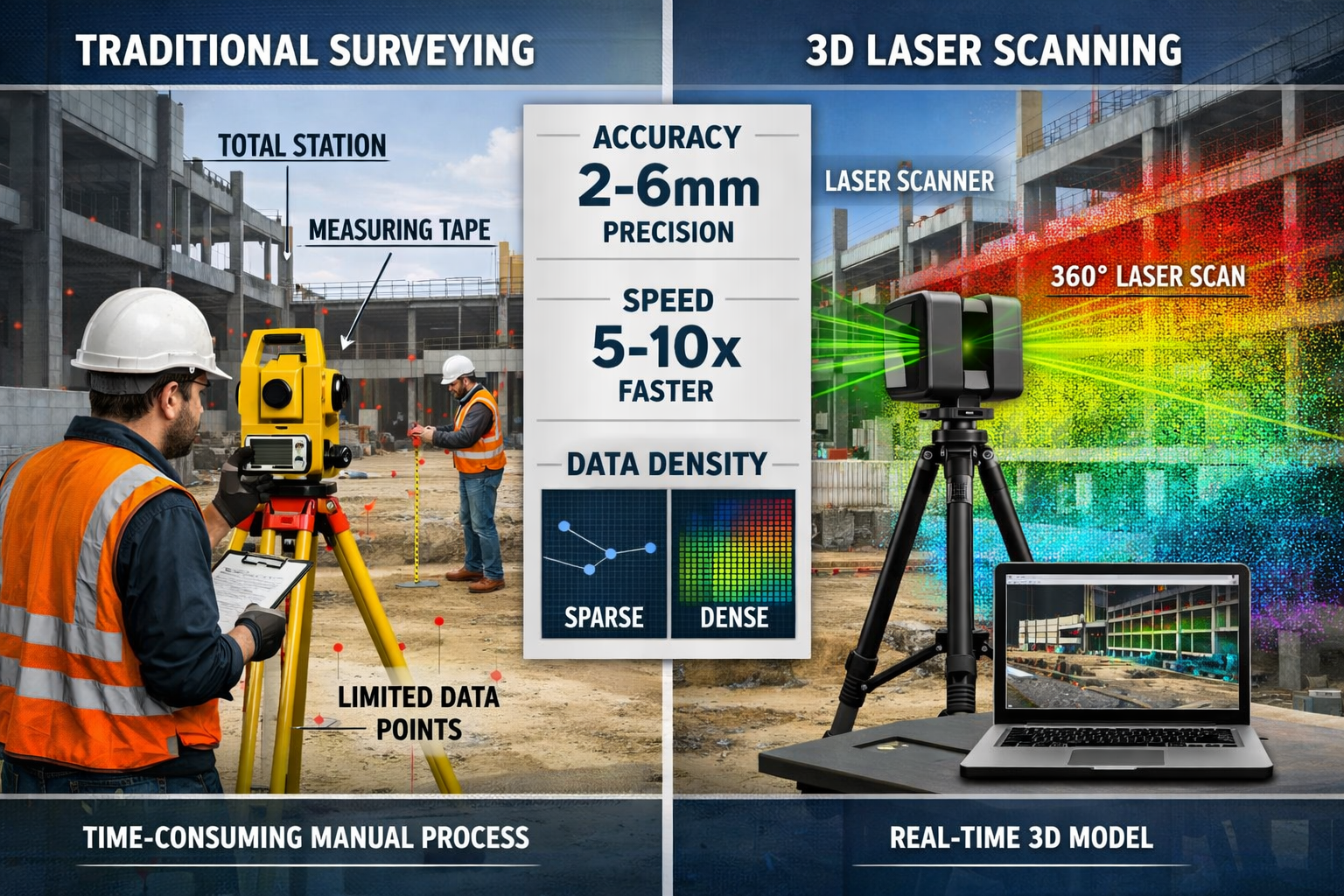
How 3D Laser Scanning Differs from Traditional Surveying Methods
Traditional property surveying relies heavily on manual measurements using tools like tape measures, levels, and total stations. While these methods have served the industry for decades, they suffer from inherent limitations:
Traditional Surveying Limitations:
- 📏 Captures only selected points, missing comprehensive spatial data
- ⏰ Time-intensive, requiring extensive fieldwork
- 👤 Susceptible to human error and measurement inconsistencies
- 📊 Limited data density makes complex environments challenging
- 🔄 Requires multiple site visits for different measurement needs
3D Laser Scanning Advantages:
- 🎯 Captures complete surface data with 2-6mm accuracy across entire environments[2]
- ⚡ 5-10 times faster than traditional methods, completing in days what took weeks[2]
- 🤖 Automated data collection eliminates human measurement errors
- 💾 Millions of data points provide comprehensive spatial documentation
- 🔁 Single comprehensive scan serves multiple project needs
When conducting a Level 3 Full Building Survey, the difference becomes immediately apparent. Traditional methods might capture several hundred discrete measurements, while laser scanning documents every surface detail with millions of precise points.
Types of 3D Laser Scanners Used in Construction
The market offers various scanner types, each optimized for specific applications:
| Scanner Type | Range | Accuracy | Best Applications | Typical Cost |
|---|---|---|---|---|
| Short-Range | 0.5-30m | ±1-3mm | Interior spaces, detailed architectural features | $15,000-$35,000 |
| Medium-Range | 30-120m | ±2-6mm | Building exteriors, construction sites | $35,000-$65,000 |
| Long-Range | 120-350m+ | ±3-10mm | Infrastructure, large facilities, topographic surveys | $65,000-$100,000+ |
| Mobile Scanners | Variable | ±5-20mm | Rapid site documentation, large areas | $25,000-$80,000 |
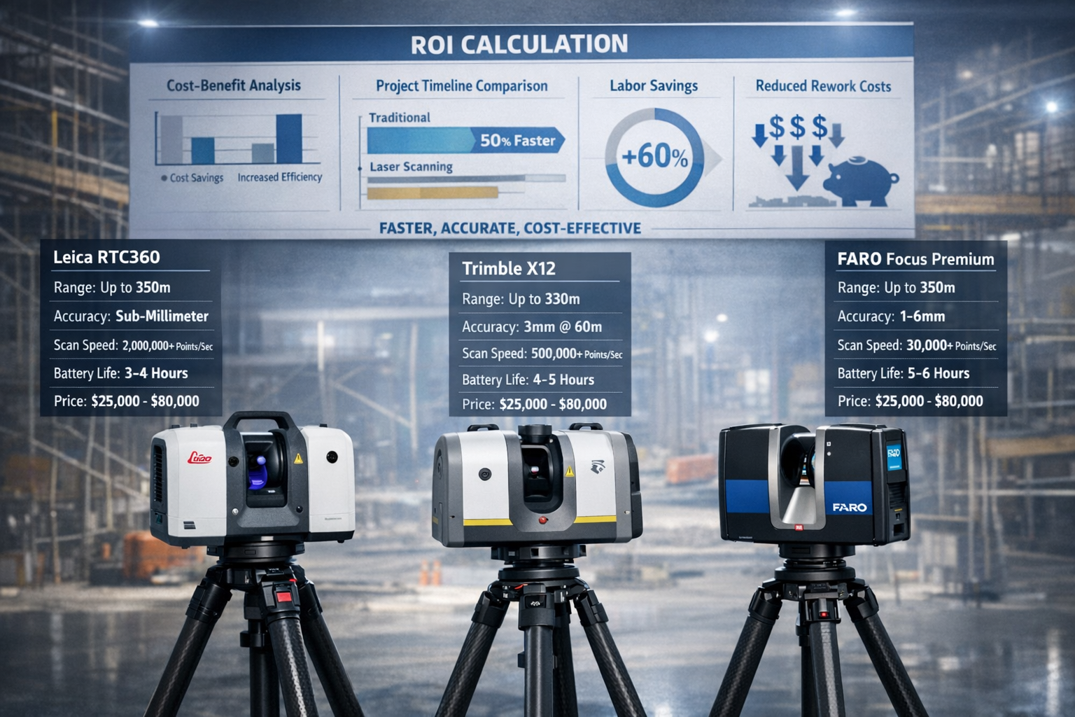
Popular Equipment Models in 2026:
🔹 Leica RTC360 – Industry-leading speed with automated field registration, ideal for construction documentation
🔹 Trimble X12 – Long-range capability with exceptional accuracy for large-scale projects
🔹 Faro Focus Premium – Versatile mid-range scanner with excellent indoor/outdoor performance
🔹 GeoSLAM ZEB Series – Mobile mapping solutions for rapid site capture
The choice of equipment depends on project requirements, budget constraints, and specific accuracy needs. When evaluating construction and condition surveys, professionals must balance initial investment against long-term operational benefits.
The Unmatched Accuracy of 3D Laser Scanning in Property Surveying: Achieving Precision for Construction Projects
Quantifying Accuracy: The Numbers That Matter
The precision of 3D Laser Scanning in Property Surveying: Achieving Unmatched Accuracy for Construction Projects isn't merely marketing hyperbole—it's backed by measurable performance metrics that fundamentally change what's possible in construction documentation.
Modern terrestrial laser scanners consistently achieve 2-6 millimeter accuracy across entire building surfaces, with premium systems reaching sub-millimeter precision under optimal conditions[2]. To put this in perspective, that's roughly the thickness of two or three credit cards—across distances spanning hundreds of meters.
Accuracy Breakdown by Application:
✨ Structural Documentation: ±2-3mm for steel framework and concrete elements
✨ MEP Systems Mapping: ±3-5mm for pipes, ducts, and electrical conduits
✨ Architectural Details: ±1-2mm for facades, ornamental features, and finishes
✨ Topographic Surveys: ±5-10mm for site grading and earthwork volumes
This level of precision transforms how construction professionals approach building defects surveys, enabling detection of issues that would be invisible to traditional surveying methods.
Speed and Efficiency Gains
Beyond accuracy, speed represents perhaps the most compelling advantage of laser scanning technology. The efficiency gains are substantial and directly impact project timelines and budgets.
Comparative Timeline Analysis:
| Project Type | Traditional Survey | 3D Laser Scanning | Time Savings |
|---|---|---|---|
| Small commercial building (5,000 sq ft) | 3-5 days | 4-8 hours | 85-90% |
| Medium warehouse (50,000 sq ft) | 2-3 weeks | 2-3 days | 80-85% |
| Large industrial facility (200,000 sq ft) | 6-8 weeks | 1-2 weeks | 75-80% |
| Complex MEP documentation | 4-6 weeks | 3-5 days | 90-95% |
Modern scanners capture data at extraordinary rates—up to 30,000 points per second—enabling complete documentation of complex environments in minutes rather than hours[5]. A typical commercial building interior that might require days of traditional measurement can be comprehensively scanned in a single afternoon.
"3D laser scanning completes data collection 5-10 times faster than traditional surveying methods, with projects requiring weeks using conventional approaches often finishing in days using laser scanning." [2]
This speed advantage doesn't compromise quality. In fact, the comprehensive nature of point cloud data means surveyors capture everything within the scanner's field of view, eliminating the risk of missing critical details that might require costly return visits.
Data Density and Comprehensive Coverage
The concept of data density fundamentally distinguishes laser scanning from traditional surveying. Where conventional methods might capture several hundred discrete measurement points, laser scanners document millions of precise data points in comparable timeframes[1].
Data Capture Comparison:
📊 Traditional Total Station Survey
- 200-500 discrete points per day
- Selected features only
- Gaps between measurements
- Limited spatial context
📊 3D Laser Scanning
- 5-10 million points per setup
- Complete surface documentation
- Continuous spatial data
- Full environmental context
This comprehensive coverage proves invaluable when conducting building materials assessments, as every surface detail is captured for later analysis without requiring additional site visits.
Scanners typically capture comprehensive environmental data within a 30-meter radius from each setup position, collecting context and identifying utilities, structural elements, or potential conflicts before construction begins[1]. This spatial awareness enables designs to align with existing conditions from the project's inception rather than discovering conflicts during construction.
Accuracy in Complex and Challenging Environments
The true test of any surveying technology lies in its performance under challenging conditions. 3D Laser Scanning in Property Surveying: Achieving Unmatched Accuracy for Construction Projects excels precisely where traditional methods struggle most.
Complex Environment Applications:
🏗️ Active Construction Sites – Scanners capture accurate data without slowing for obstacles, documenting as-built conditions amid ongoing work[3]
🏭 Industrial Facilities – Dense pipe racks, elevated equipment, and confined spaces pose no special challenges to laser scanning
🏛️ Historic Buildings – Intricate architectural details and fragile structures benefit from non-contact measurement
🌉 Infrastructure Projects – Bridges, tunnels, and elevated structures are documented safely from ground level
The technology particularly shines when documenting as-built conditions that deviate from original plans. Construction reality rarely matches design intent perfectly, and laser scanning captures these variations with precision that enables accurate modeling and conflict resolution.
For professionals managing building pathology investigations, the ability to detect millimeter-level variations proves invaluable. Structural movement, settlement, and deformation become quantifiable rather than subjective, supporting evidence-based decision-making.
Equipment Selection and ROI Analysis for 3D Laser Scanning in Property Surveying
Evaluating Equipment Options: Features That Matter
Selecting the right laser scanning equipment requires careful consideration of project requirements, budget constraints, and long-term operational needs. The market offers numerous options, each with distinct capabilities and trade-offs.
Critical Equipment Selection Criteria:
🎯 Range and Accuracy Requirements
- Match scanner capabilities to typical project distances
- Consider whether sub-millimeter precision justifies premium costs
- Evaluate accuracy degradation across the full range spectrum
⚡ Scan Speed and Point Density
- Higher point capture rates reduce field time
- Adjustable resolution settings optimize speed versus detail
- Consider whether 30,000+ Hz scan rates justify additional investment
🔋 Battery Life and Field Durability
- Assess typical daily workload and charging opportunities
- Evaluate weather resistance for outdoor applications
- Consider ruggedness for active construction environments
💻 Software Integration and Workflow
- Compatibility with existing CAD/BIM platforms
- Ease of data processing and point cloud management
- Cloud collaboration capabilities for remote teams
📱 Automation Features
- Automatic registration reduces processing time
- Built-in photography for colorized point clouds
- Self-leveling and environmental compensation
Equipment Investment Ranges (2026 Pricing):
| Investment Level | Equipment Cost | Typical Applications | Expected ROI Timeline |
|---|---|---|---|
| Entry Level | $15,000-$30,000 | Small buildings, interior documentation | 6-12 months |
| Mid-Range | $30,000-$65,000 | General construction, commercial projects | 8-18 months |
| Premium | $65,000-$100,000+ | Large infrastructure, high-precision work | 12-24 months |
When planning equipment acquisition, consider that the 3D laser scanning services market is projected to grow from $8.84 billion in 2025 to $12.85 billion by 2030, representing a 7.5% compound annual growth rate[8]. This expansion indicates strong demand and favorable market conditions for firms investing in scanning capabilities.
Calculating Return on Investment (ROI)
Understanding the financial impact of 3D Laser Scanning in Property Surveying: Achieving Unmatched Accuracy for Construction Projects requires comprehensive ROI analysis that extends beyond simple equipment costs.
ROI Calculation Framework:
Direct Cost Savings:
- ✅ Reduced field labor (fewer personnel, shorter site visits)
- ✅ Decreased travel expenses (comprehensive single-visit data capture)
- ✅ Lower equipment costs (one scanner versus multiple traditional tools)
- ✅ Minimized rework expenses (accuracy reduces errors)
Indirect Benefits:
- 💰 Increased project capacity (faster turnaround enables more work)
- 💰 Competitive advantage (technology differentiation wins contracts)
- 💰 Enhanced safety (reduced hazardous environment exposure)
- 💰 Improved client satisfaction (superior deliverables)
Sample ROI Calculation: Mid-Size Surveying Firm
Initial Investment:
- Scanner equipment: $50,000
- Processing software: $8,000
- Training and certification: $5,000
- Total Initial Investment: $63,000
Annual Benefits:
- Labor savings (2 fewer field days per project × 24 projects × $1,200/day): $57,600
- Reduced rework (5% error reduction × $240,000 annual revenue): $12,000
- Additional project capacity (20% more projects × $10,000 average margin): $48,000
- Total Annual Benefits: $117,600
ROI Calculation:
- Payback Period: 6.4 months
- First-Year ROI: 87%
- Three-Year ROI: 460%
These calculations demonstrate why companies transitioning to 3D laser scanning can complete more work with reduced manpower and time while achieving reduced project costs and increased company profits[3].
Cost-Benefit Analysis: Beyond Equipment Costs
A comprehensive cost-benefit analysis extends beyond initial equipment investment to encompass the full operational impact.
Operational Cost Comparison (Per Project):
| Cost Category | Traditional Survey | 3D Laser Scanning | Savings |
|---|---|---|---|
| Field labor (personnel × days) | $4,800 (4 people × 3 days) | $1,600 (2 people × 2 days) | $3,200 |
| Travel/accommodation | $1,200 | $400 | $800 |
| Equipment depreciation | $200 | $300 | -$100 |
| Processing time | $800 | $1,200 | -$400 |
| Total Project Cost | $7,000 | $3,500 | $3,500 |
The 50% cost reduction per project quickly compounds across annual workload, while simultaneously improving deliverable quality and client satisfaction.
Hidden Value Propositions:
🎁 Risk Mitigation – Comprehensive documentation reduces liability exposure and dispute resolution costs
🎁 Competitive Positioning – Technology adoption attracts premium clients willing to pay for superior accuracy
🎁 Staff Retention – Modern tools improve job satisfaction and attract talented professionals
🎁 Scalability – Laser scanning enables geographic expansion without proportional staff increases
For firms conducting project management services, the ability to provide accurate as-built documentation and progress monitoring creates additional revenue streams beyond traditional surveying fees.
Maintenance and Operational Considerations
Long-term equipment ownership requires understanding ongoing maintenance requirements and operational costs.
Annual Operational Expenses:
📋 Calibration and Certification: $1,500-$3,000 annually
📋 Software Licenses and Updates: $2,000-$5,000 annually
📋 Equipment Insurance: $800-$1,500 annually
📋 Consumables and Accessories: $500-$1,000 annually
📋 Professional Development: $1,000-$2,500 annually
Total Annual Operating Costs: $5,800-$13,000
While these expenses are significant, they pale in comparison to the revenue generation and cost savings enabled by the technology. Most firms find that a single large project often generates sufficient margin to cover annual operational expenses.
Equipment Lifecycle Management:
Modern laser scanners typically maintain accuracy specifications for 5-7 years with proper maintenance, though technological advancement may drive earlier replacement to remain competitive. Establishing equipment refresh cycles and budgeting for periodic upgrades ensures firms maintain state-of-the-art capabilities.
Practical Applications of 3D Laser Scanning in Property Surveying: Achieving Results for Construction Projects
BIM Integration and Digital Twin Development
The integration of 3D Laser Scanning in Property Surveying: Achieving Unmatched Accuracy for Construction Projects with Building Information Modeling (BIM) represents one of the most transformative applications in modern construction.
Research studies conducted from 2024 to 2026 consistently demonstrate that integrating BIM with laser scanning significantly improves accuracy of progress tracking and reduces manual inspection effort[4]. This integration replaces opinion-based assessments with objective, spatial evidence that stakeholders can visualize and analyze.
BIM Integration Workflow:
1️⃣ Initial Site Capture – Comprehensive laser scanning establishes baseline conditions
2️⃣ Point Cloud Registration – Multiple scans aligned into unified coordinate system
3️⃣ Model Development – Point clouds inform accurate as-built BIM creation
4️⃣ Design Overlay – Planned construction compared against existing conditions
5️⃣ Clash Detection – Automated identification of conflicts before construction
6️⃣ Progress Monitoring – Periodic rescanning tracks construction advancement
Digital Twin Benefits:
🔷 Virtual Site Access – Remote stakeholders explore accurate 3D environments
🔷 Simulation Capabilities – Test construction sequences and logistics digitally
🔷 Facility Management – Comprehensive as-built data supports ongoing operations
🔷 Renovation Planning – Future modifications benefit from accurate existing conditions
Periodic LiDAR scans—conducted daily, weekly, or at milestone intervals—registered with design or 4D BIM models enable automated point cloud-to-BIM comparisons that identify what has been built, what remains incomplete, and work falling outside allowable tolerances[4]. This automated verification prevents costly MEP system conflicts that traditionally emerge during construction.
As-Built Documentation and Progress Monitoring
Construction projects increasingly rely on laser scanning for as-built documentation, progress monitoring, and quality control, with particular effectiveness for documenting complex MEP systems, structural elements, and architectural details[2].
As-Built Documentation Applications:
📸 MEP Systems – Precise mapping of installed pipes, ducts, conduits, and equipment locations for facility management and future renovations
📸 Structural Elements – Verification of column locations, beam elevations, and floor levelness against design specifications
📸 Architectural Features – Documentation of facades, interior finishes, and custom millwork for warranty and maintenance purposes
📸 Site Conditions – Topographic documentation of grading, drainage, and hardscape installations
The comprehensive nature of point cloud data means that measurements not initially anticipated can be extracted months or years later without returning to the site—a capability impossible with traditional selective surveying.
Progress Monitoring Methodology:
Weekly or bi-weekly scanning of active construction creates a temporal record of project advancement. Comparing sequential scans reveals:
- ✔️ Quantities of materials installed
- ✔️ Percentage completion by building zone
- ✔️ Schedule adherence and productivity metrics
- ✔️ Quality compliance with dimensional tolerances
This objective documentation supports accurate payment applications, dispute resolution, and schedule recovery planning when projects fall behind.
Structural Health Monitoring and Defect Detection
High-density point cloud data enables detection of millimeter-level movement, providing comprehensive insight into structural behavior and complementing conventional sensors by offering full-field geometry context[4].
Structural Monitoring Applications:
🏗️ Settlement Analysis – Periodic scanning detects foundation movement and differential settlement patterns
🏗️ Deformation Tracking – Monitoring of walls, floors, and roofs identifies structural distress before failure
🏗️ Load Testing Verification – Documentation of structural response under controlled loading conditions
🏗️ Vibration Impact Assessment – Quantifying effects of adjacent construction or traffic on sensitive structures
When conducting statutory considerations for party wall matters or neighboring property protection, laser scanning provides irrefutable baseline documentation and ongoing monitoring capabilities.
Defect Detection Capabilities:
The precision of laser scanning reveals construction defects that might otherwise remain hidden until they cause problems:
- 🔍 Out-of-plumb walls exceeding tolerance
- 🔍 Floor levelness variations affecting finishes
- 🔍 Ceiling height discrepancies
- 🔍 Facade alignment issues
- 🔍 Concrete formwork irregularities
Early detection enables corrective action while work remains accessible, avoiding expensive remediation after subsequent construction conceals the defect.
Safety Enhancement in Hazardous Environments
3D laser scanning minimizes personnel risks by capturing accurate data from a distance, eliminating the need for scaffolding, harnesses, and protective gear when surveying bridges, high roofs, or unstable structures, while maintaining high-quality results[1].
Safety Applications:
⚠️ Elevated Structures – Bridges, towers, and building roofs documented from ground level
⚠️ Confined Spaces – Tanks, tunnels, and mechanical rooms surveyed with minimal entry
⚠️ Hazardous Materials – Asbestos-containing buildings documented with reduced exposure
⚠️ Unstable Conditions – Damaged structures assessed without personnel entry
⚠️ Active Traffic Areas – Roadways and railways surveyed with minimal lane closures
For firms conducting asbestos building surveys, laser scanning enables comprehensive spatial documentation while minimizing surveyor exposure to potentially hazardous materials.
The safety benefits extend beyond immediate risk reduction. Fewer personnel in hazardous locations means lower insurance premiums, reduced liability exposure, and improved workplace safety records—all contributing to long-term business sustainability.
Remote Collaboration and Stakeholder Communication
Modern construction projects involve geographically distributed teams requiring access to accurate, current project information. 3D Laser Scanning in Property Surveying: Achieving Unmatched Accuracy for Construction Projects facilitates unprecedented collaboration capabilities.
Collaboration Advantages:
🌐 Cloud-Based Access – Teams from architects and designers to subcontractors access the same up-to-date 3D model remotely[1]
🌐 Virtual Walkthroughs – Stakeholders explore sites without physical visits, accelerating decision-making
🌐 Measurement Extraction – Remote team members extract dimensions and verify conditions independently
🌐 Issue Coordination – Problems identified and communicated with precise spatial context
🌐 Client Presentations – Impressive visualizations enhance client communication and approval processes
This capability proved particularly valuable during recent global events that limited site access, and continues to provide efficiency benefits as hybrid work models become standard in the construction industry.
The elimination of guesswork accelerates decision-making when project pivots are needed, as all stakeholders work from identical, accurate spatial information rather than relying on interpretations of traditional drawings or incomplete field notes[1].
Future Trends and Industry Outlook for 3D Laser Scanning in Construction
Market Growth and Technology Adoption
The trajectory of 3D Laser Scanning in Property Surveying: Achieving Unmatched Accuracy for Construction Projects points toward continued rapid expansion and technological advancement.
The 3D laser scanning services market demonstrates robust growth, projected to expand from $8.84 billion in 2025 to $12.85 billion by 2030, representing a 7.5% compound annual growth rate (CAGR)[8]. This growth is driven by several converging factors:
Market Growth Drivers:
📈 AI and Machine Learning Integration – Automated feature extraction and object recognition
📈 Digital Twin Adoption – Facilities management and smart building initiatives
📈 Infrastructure Investment – Government spending on transportation and utilities
📈 Sustainability Requirements – Energy modeling and retrofit documentation needs
📈 Technology Cost Reduction – More affordable equipment expands market accessibility
The construction industry's digital transformation continues accelerating, with laser scanning positioned as a foundational technology enabling broader BIM adoption, prefabrication workflows, and data-driven project management.
Emerging Technologies and Innovations
Several technological developments promise to further enhance laser scanning capabilities and applications:
Innovation Frontiers:
🚀 Mobile and Wearable Scanning – Handheld and backpack-mounted systems enable rapid large-area documentation
🚀 Drone-Mounted LiDAR – Aerial scanning complements terrestrial systems for comprehensive site coverage, similar to premium drone surveys
🚀 Real-Time Processing – On-site data processing eliminates post-processing delays
🚀 AI-Powered Analysis – Automated defect detection and quality verification
🚀 Augmented Reality Integration – Overlaying scan data onto physical environments for field verification
🚀 Sensor Fusion – Combining laser scanning with thermal imaging, GPR, and other technologies
These innovations will further reduce costs, accelerate workflows, and expand application possibilities across the construction lifecycle.
Skills Development and Training Requirements
As 3D Laser Scanning in Property Surveying: Achieving Unmatched Accuracy for Construction Projects becomes standard practice, workforce development becomes critical.
Essential Skill Sets:
🎓 Equipment Operation – Proper scanner setup, calibration, and field procedures
🎓 Data Processing – Point cloud registration, cleaning, and optimization
🎓 Software Proficiency – CAD/BIM platforms, visualization tools, and analysis applications
🎓 Quality Control – Verification procedures and accuracy validation
🎓 Client Communication – Explaining technology benefits and deliverable interpretation
Professional organizations offer certification programs and training courses that validate competency and support career development. Firms investing in staff training realize faster ROI through efficient workflows and higher-quality deliverables.
The skills gap in construction technology creates opportunities for professionals who master laser scanning capabilities, with experienced operators commanding premium compensation in competitive markets.
Integration with Broader Construction Technology Ecosystems
Laser scanning doesn't exist in isolation but rather integrates within comprehensive technology ecosystems that include:
Technology Stack Components:
🔧 Project Management Platforms – Integration with scheduling and coordination software
🔧 Reality Capture Suite – Combining photogrammetry, 360° photography, and laser scanning
🔧 Cloud Collaboration Tools – Centralized data repositories and stakeholder access
🔧 Analytics and Reporting – Automated progress tracking and quantity verification
🔧 Facility Management Systems – As-built data feeding operations and maintenance platforms
This ecosystem approach maximizes value extraction from scanning investments, as data flows seamlessly between applications supporting different project phases and stakeholder needs.
Understanding why property owners hire surveyors increasingly includes recognition of technology capabilities that traditional surveying cannot match.
Overcoming Implementation Challenges and Best Practices
Common Implementation Obstacles
Despite clear benefits, firms adopting 3D Laser Scanning in Property Surveying: Achieving Unmatched Accuracy for Construction Projects encounter predictable challenges:
Implementation Challenges:
⚡ Initial Capital Requirements – Equipment investment creates cash flow considerations
⚡ Learning Curve – Staff training and workflow adaptation require time
⚡ Data Management – Large file sizes demand storage infrastructure and procedures
⚡ Client Education – Explaining technology benefits and deliverable formats
⚡ Workflow Integration – Incorporating scanning into established business processes
Successful implementation requires addressing these challenges proactively through planning, training, and phased adoption strategies.
Best Practices for Successful Deployment
Organizations achieving rapid ROI and smooth technology adoption typically follow proven best practices:
Deployment Best Practices:
✅ Start with Pilot Projects – Prove capabilities on internal or low-risk projects before client work
✅ Invest in Training – Comprehensive staff development prevents expensive mistakes and inefficient workflows
✅ Establish Standards – Document procedures for scanning, processing, and deliverable creation
✅ Build Partnerships – Collaborate with equipment vendors and experienced practitioners
✅ Communicate Value – Educate clients on technology benefits and superior deliverables
✅ Plan Data Management – Implement robust storage, backup, and archival procedures
✅ Monitor Performance – Track project metrics to demonstrate ROI and identify improvement opportunities
Firms that view laser scanning adoption as a business transformation rather than simple equipment purchase achieve better outcomes and faster returns.
Quality Assurance and Accuracy Verification
Maintaining the accuracy that defines 3D Laser Scanning in Property Surveying: Achieving Unmatched Accuracy for Construction Projects requires rigorous quality assurance procedures:
QA/QC Protocols:
🔍 Pre-Scan Verification – Equipment calibration checks and target placement
🔍 Field Procedures – Systematic scan planning and overlap verification
🔍 Registration Accuracy – Multi-scan alignment error assessment
🔍 Point Cloud Quality – Noise filtering and completeness verification
🔍 Deliverable Validation – Final model accuracy confirmation against control points
Professional standards and industry guidelines provide frameworks for quality assurance that support defensible, reliable deliverables meeting client expectations and regulatory requirements.
Conclusion: Embracing the Future of Property Surveying with 3D Laser Scanning
3D Laser Scanning in Property Surveying: Achieving Unmatched Accuracy for Construction Projects has evolved from emerging technology to essential capability in 2026. The combination of 2-6 millimeter accuracy, 5-10 times faster data collection, and comprehensive spatial documentation fundamentally transforms how construction professionals approach surveying, documentation, and project management.
The financial case is compelling: equipment investments typically achieve payback within 6-18 months, while ongoing operational benefits include reduced labor costs, minimized rework expenses, enhanced safety, and competitive differentiation. As the market grows toward $12.85 billion by 2030, firms without laser scanning capabilities risk obsolescence in an increasingly technology-driven industry.
Beyond immediate project benefits, laser scanning enables broader digital transformation through BIM integration, digital twin development, and data-driven decision-making that improves outcomes across the construction lifecycle. From initial site documentation through ongoing facility management, the comprehensive spatial data captured by laser scanners provides value for decades.
Actionable Next Steps
For construction professionals, property surveyors, and building owners ready to leverage 3D Laser Scanning in Property Surveying: Achieving Unmatched Accuracy for Construction Projects, consider these immediate actions:
For Surveying Firms:
- Conduct ROI Analysis – Calculate potential returns based on current project mix and pricing
- Research Equipment Options – Evaluate scanners matching typical project requirements and budget
- Develop Implementation Plan – Outline training, workflow integration, and pilot project strategy
- Explore Financing Options – Consider leasing or phased acquisition to manage cash flow
- Engage with Vendors – Request demonstrations and discuss application-specific capabilities
For Construction Project Managers:
- Specify Laser Scanning – Include scanning requirements in project specifications and contracts
- Leverage Scan Data – Integrate point clouds into BIM workflows and coordination processes
- Monitor Progress – Implement periodic scanning for objective progress tracking
- Document As-Builts – Ensure comprehensive scanning before closeout for facility management
For Property Owners:
- Request Technology Capabilities – Ask service providers about laser scanning availability
- Understand Deliverables – Learn how point cloud data supports renovation and management
- Invest in Documentation – Consider baseline scanning for valuable or complex properties
- Plan for Future Needs – Recognize how current scanning supports future modification projects
The construction industry stands at a technological inflection point where traditional methods increasingly cannot meet modern project demands for speed, accuracy, and comprehensive documentation. 3D Laser Scanning in Property Surveying: Achieving Unmatched Accuracy for Construction Projects provides the solution, delivering measurable benefits that improve project outcomes while reducing costs and risks.
Whether conducting a Level 3 Full Building Survey, managing complex construction projects, or planning facility renovations, laser scanning technology offers capabilities that were unimaginable just years ago. The question is no longer whether to adopt this technology, but how quickly firms can implement it to remain competitive in an evolving marketplace.
The future of property surveying is already here—precise, efficient, comprehensive, and powered by laser light traveling at the speed of innovation. Organizations embracing this future position themselves for success in an industry where accuracy isn't just desirable—it's unmatched and essential.
References
[1] 3d Laser Scanning Construction – https://matterport.com/blog/3d-laser-scanning-construction
[2] 3d Scanning Vs Traditional Surveying Guide – https://iscano.com/laser-scanning-lidar-best-practices/3d-scanning-vs-traditional-surveying-guide/
[3] 3d Laser Scanning Used In Land Surveying – https://www.duncan-parnell.com/blog/108/3d-laser-scanning-used-in-land-surveying
[4] 7 Reasons To Use Lidar Construction Laser Scanning – https://blog.brightergraphics.com/7-reasons-to-use-lidar-construction-laser-scanning
[5] When To Add 3d Laser Scanning To Your Surveying Capabilities – https://blog.hexagongeosystems.com/when-to-add-3d-laser-scanning-to-your-surveying-capabilities/
[8] 3d Laser Scanning Services Global Market Report – https://www.thebusinessresearchcompany.com/report/3d-laser-scanning-services-global-market-report