The commercial real estate industry stands at a critical juncture. On February 23, 2026, sweeping changes to the ALTA/NSPS Land Title Survey Standards take effect, fundamentally reshaping how surveyors document properties and how title professionals assess risk. For CRE professionals who have relied on the 2021 standards for years, understanding the 2026 ALTA/NSPS Land Title Survey Updates: What CRE Professionals Need to Know is no longer optional—it's essential for maintaining compliance, avoiding transaction delays, and protecting client interests.
These updates represent the most comprehensive revision to land title survey standards in recent years, introducing new documentation requirements, clarifying longstanding ambiguities, and establishing enhanced protocols for utility features and encroachment reporting. Whether you're a commercial real estate broker, property developer, lender, or title insurance professional, the changes outlined in this guide will directly impact your daily operations and transaction workflows.
Key Takeaways
- February 23, 2026 marks the mandatory compliance deadline—all surveys begun on or after this date must follow the new 2026 standards, replacing the 2021 version entirely.[1][3]
- New Table A Item 20 introduces standardized encroachment reporting—surveyors must now provide a comprehensive summary table documenting potential encroachments over boundary lines, into easements, and into setbacks when requested.[1][3]
- Enhanced utility documentation requirements—utility poles within 10 feet and other utility features within 5 feet of the property must be identified and documented, significantly expanding surveyor responsibilities.[1]
- Improved clarity and communication focus—the standards prioritize refined language, resolved inconsistencies, and clarified responsibilities to reduce confusion among all stakeholders.[1]
- Expanded flexibility for certifications and imagery—lenders can now request certification extensions to successors and assigns, while aerial and satellite imagery usage has been broadened with proper documentation.[1][3]
Understanding the 2026 ALTA/NSPS Land Title Survey Standards Framework

The American Land Title Association (ALTA) and the National Society of Professional Surveyors (NSPS) have maintained collaborative standards for land title surveys since 1962. These standards create uniformity in commercial real estate transactions across the United States, ensuring that lenders, title companies, and property owners receive consistent, reliable survey information regardless of geographic location.
What Makes ALTA/NSPS Surveys Different?
Unlike basic boundary surveys or topographic surveys, ALTA/NSPS Land Title Surveys serve a specific purpose in commercial real estate transactions. They provide comprehensive information about property boundaries, improvements, easements, encroachments, and access—all critical factors in title insurance underwriting and lending decisions.
Key distinguishing features include:
- Standardized Table A items that allow clients to select specific survey elements
- Certification to multiple parties including purchasers, lenders, and title companies
- Rigorous accuracy standards based on defined measurement precision
- Comprehensive documentation of visible improvements and potential title issues
- Professional liability backed by surveyor certifications and insurance
For those familiar with different types of building surveys, ALTA/NSPS surveys represent the commercial real estate equivalent—highly specialized assessments designed for specific transaction requirements.
The Evolution from 2021 to 2026 Standards
The 2021 standards served the industry well, but practical application revealed areas requiring clarification and enhancement. The 2026 updates address these gaps while maintaining the fundamental framework that CRE professionals have come to rely upon.
Primary drivers for the 2026 revision:
- Inconsistent interpretation of certain requirements across different regions
- Technological advances in surveying equipment and imagery sources
- Industry feedback regarding practical implementation challenges
- Risk management concerns from title insurers and lenders
- Evolving property complexity in modern commercial developments
The revision process involved extensive collaboration between ALTA, NSPS, surveying professionals, title companies, and lenders to ensure the updates address real-world needs while maintaining practical feasibility.[2]
Critical Changes in the 2026 ALTA/NSPS Land Title Survey Updates: What CRE Professionals Need to Know
The February 23, 2026 effective date represents more than a calendar milestone—it marks a fundamental shift in survey documentation practices. Understanding these specific changes enables CRE professionals to prepare adequately and avoid costly compliance issues.
The February 23, 2026 Compliance Deadline ⏰
All surveys commenced on or after February 23, 2026 must comply with the new standards. This hard deadline creates a clear demarcation point in the industry, requiring immediate adaptation from surveyors and updated expectations from clients.[1][3]
What "commenced" means:
- The date the surveyor begins fieldwork
- NOT the date of the survey order or engagement letter
- NOT the date of the final survey delivery
This distinction matters significantly for projects in progress during the transition period. Surveyors who begin fieldwork on February 22, 2026 may complete their work under the 2021 standards, while those starting just one day later must follow the 2026 requirements entirely.
Practical implications for CRE professionals:
| Scenario | Required Standard | Action Needed |
|---|---|---|
| Survey ordered Jan 2026, fieldwork starts Feb 20, 2026 | 2021 Standards | No changes required |
| Survey ordered Jan 2026, fieldwork starts Feb 24, 2026 | 2026 Standards | Update order requirements |
| Survey ordered Mar 2026, fieldwork starts Mar 15, 2026 | 2026 Standards | Use new Table A items |
| Existing 2021 survey being updated in Mar 2026 | 2026 Standards | Full compliance required |
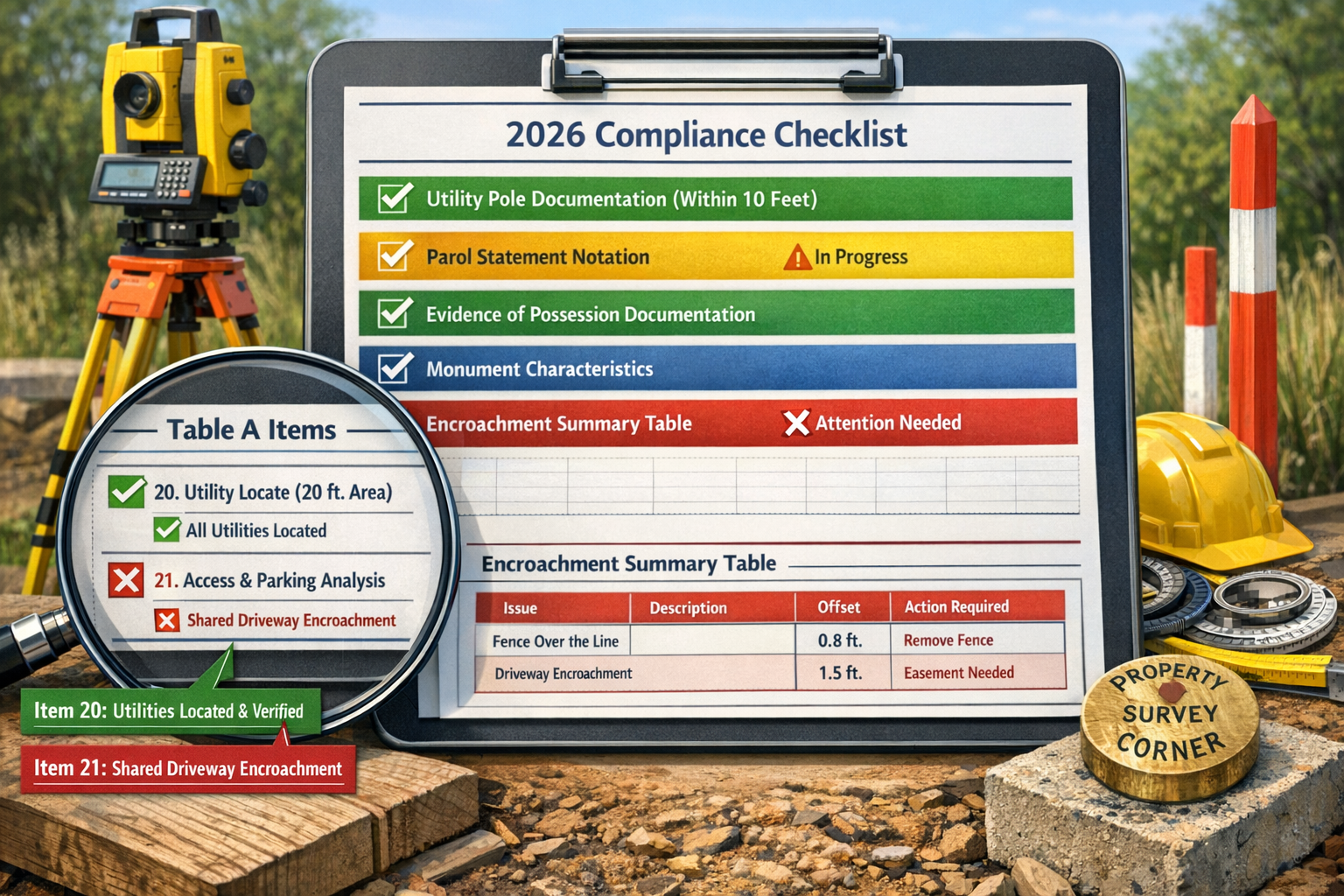
Table A Item 20: The New Encroachment Summary Table 📊
Perhaps the most significant practical change involves the introduction of Table A Item 20, which creates a standardized approach to documenting potential encroachments. When clients request this optional item, surveyors must include a comprehensive summary table on the survey face.[1][3]
Required elements in the encroachment summary table:
- Encroachments over boundary lines (improvements from the subject property onto adjacent properties)
- Encroachments into rights-of-way or easements (improvements interfering with utility or access easements)
- Encroachments into setbacks (improvements violating zoning setback requirements)
- Designated conditions as specified by the client
This standardization addresses a longstanding industry challenge. Previously, encroachment documentation varied significantly between surveyors, making comparative analysis difficult and creating inconsistent risk assessment. The new table format ensures uniform presentation, enabling title companies and lenders to quickly identify potential issues.
Benefits for CRE professionals:
✅ Faster risk assessment through standardized formatting
✅ Reduced ambiguity in encroachment documentation
✅ Improved comparability across multiple properties
✅ Enhanced due diligence support for complex transactions
✅ Clearer communication with title insurers and underwriters
Similar to how Level 3 full building surveys provide comprehensive property assessments, this new encroachment table delivers systematic documentation that supports informed decision-making.
Table A Item 21: Renumbering of Custom Items
The former Table A Item 20, which allowed for negotiated surveyor-client items, has been renumbered to Item 21.[1][3] While this change appears minor, it requires immediate action from organizations using standardized survey order forms.
Required updates:
- Revise all standard survey order templates
- Update internal documentation and procedures
- Communicate changes to procurement teams
- Modify automated ordering systems
- Train staff on new item numbering
Failure to update these references could result in confusion, incorrect survey specifications, or missing critical custom requirements in commercial transactions.
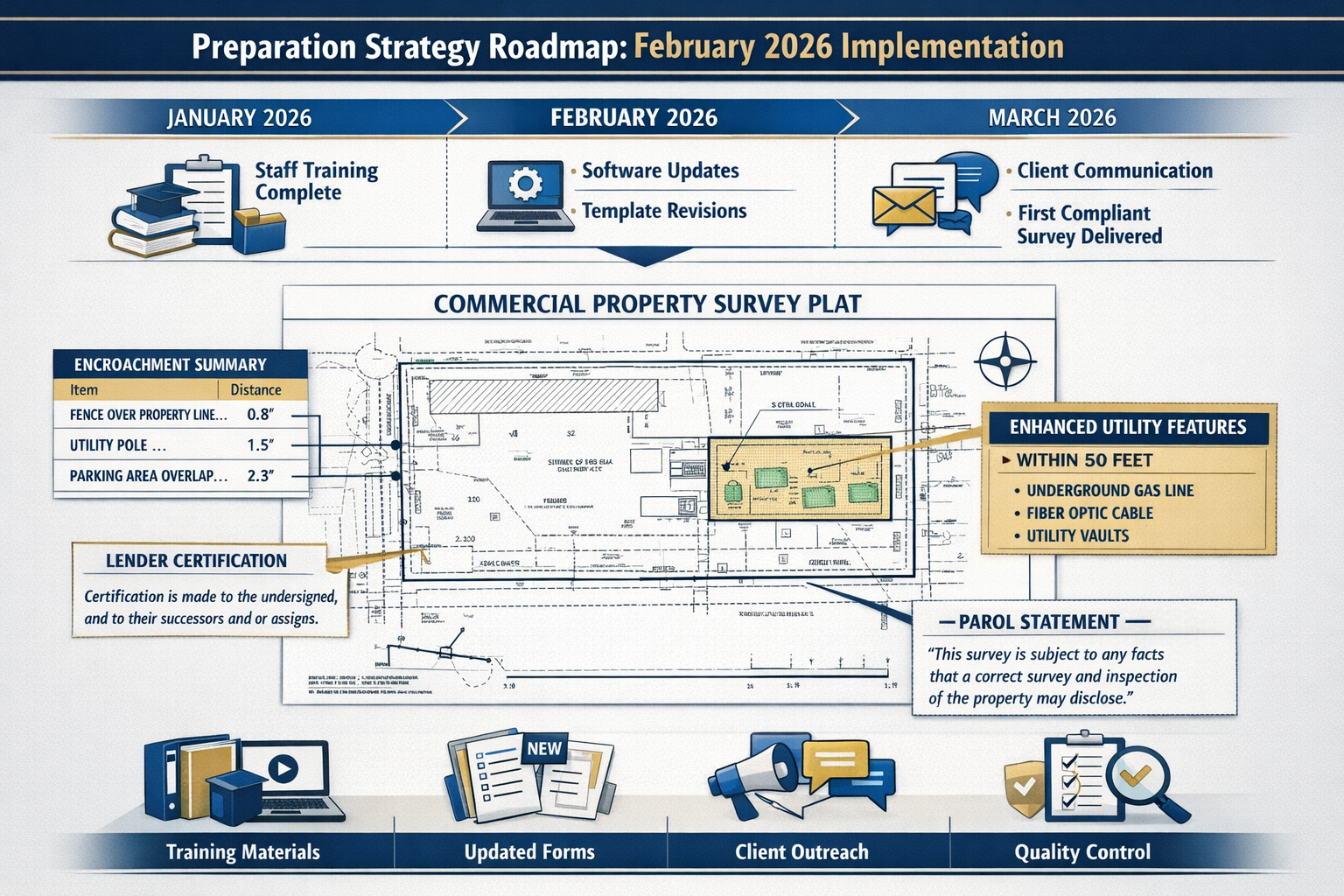
Enhanced Utility Features Documentation 🔌
The 2026 standards significantly expand utility documentation requirements, reflecting the growing complexity of modern commercial properties and the critical importance of utility infrastructure in property valuation and development potential.[1]
New distance thresholds:
- Utility poles: Must be identified and documented if located on or within 10 feet of the surveyed property
- Other utility features: Must be identified and documented if located on or within 5 feet of the surveyed property
"Other utility features" includes:
- Transformers and electrical equipment
- Telecommunications pedestals and cabinets
- Gas meter sets and regulators
- Water meters and valve boxes
- Sewer cleanouts and manholes
- Cable television equipment
- Fiber optic junction boxes
This expanded documentation provides CRE professionals with critical information for development planning, property improvements, and risk assessment. Utility conflicts represent a common source of construction delays and unexpected costs in commercial projects.
Parol Statement Documentation Requirements 💬
The 2026 standards introduce a requirement for surveyors to document parol statements—verbal communications from landowners or occupants regarding title or boundary issues.[1][3]
When documentation is required:
- Landowner claims boundary differs from record location
- Occupant asserts easement or access rights
- Adjacent property owner disputes boundary line
- Verbal agreements regarding shared improvements
- Claims of adverse possession or prescriptive easements
This requirement creates a standardized record of potentially significant title issues that might otherwise go undocumented. While parol statements don't establish legal rights, they alert title professionals to potential disputes requiring further investigation.
Best practices for CRE professionals:
- Review parol statement notations carefully during due diligence
- Request additional documentation or legal opinions when statements raise concerns
- Consider title insurance endorsements addressing specific parol claims
- Factor potential boundary disputes into transaction timelines
- Engage legal counsel early when significant parol issues emerge
Evidence of Possession or Occupation Notation
Surveyors must now note evidence of possession or occupation along the property perimeter regardless of proximity to boundary lines.[1] This requirement helps identify potential encroachments, adverse possession claims, and third-party use that might affect title.
Examples of possession evidence:
- Fencing extending beyond property boundaries
- Maintained landscaping on adjacent properties
- Parking or storage of vehicles or equipment
- Agricultural use of portions of the property
- Pathways or driveways crossing property lines
- Signage indicating third-party claims
This documentation supports comprehensive risk assessment and helps prevent post-closing disputes. Understanding which building survey you need involves similar considerations—matching the assessment level to the transaction's risk profile.
Refined Relative Positional Precision (RPP) Definition
The 2026 standards include an updated definition of Relative Positional Precision that provides additional clarity for those unfamiliar with measurement techniques while maintaining alignment with accepted surveying practices.[1]
Why RPP matters:
RPP defines the accuracy with which survey points are positioned relative to each other. This measurement precision directly affects the reliability of boundary determinations, improvement locations, and encroachment assessments.
The refined definition helps CRE professionals better understand survey accuracy limitations and make informed decisions about when additional precision might be necessary for complex transactions or development projects.
Monument Characteristics Clarification
The standards now explicitly specify that "relationship to the ground" is an element of monument characteristics.[1] This clarification ensures surveyors document whether boundary monuments are:
- Set flush with the ground surface
- Projecting above ground level
- Below ground surface (requiring excavation to locate)
- Disturbed or damaged
This information proves valuable during property development, as monuments set below grade may require special protection during construction, while projecting monuments might need relocation to accommodate improvements.
Expanded Aerial and Satellite Imagery Use 🛰️
The 2026 standards broaden the acceptable use of aerial or satellite imagery to show features on surveys, provided that specific details of the imagery are clarified in writing before use.[3]
Acceptable imagery applications:
- Depicting large-scale site context
- Showing vegetation and landscape features
- Illustrating topographic relationships
- Documenting existing improvements
- Providing visual reference for complex properties
Required clarifications:
- Image source and acquisition date
- Resolution and accuracy specifications
- Any limitations or distortions
- Relationship to surveyed measurements
- Disclaimer regarding features not field-verified
This expansion recognizes technological advances while maintaining appropriate quality controls and disclosure requirements.
Lender Certification to Successors and Assigns
Surveyors may now extend certification of the plat or map to successors and assigns of the lender if requested, providing greater flexibility in loan transfers.[1][3]
Benefits for commercial lending:
- Simplified loan sale and securitization processes
- Reduced need for survey recertification
- Lower transaction costs in secondary markets
- Faster loan portfolio transfers
- Enhanced liquidity for commercial mortgages
This change reflects the reality of modern commercial lending, where loans frequently transfer between institutions during their term.
Deletion of Adjoining Deeds Requirement
The 2026 standards eliminated the former requirement to provide copies of adjoining deeds, which proved impractical in many markets and created unnecessary administrative burden.[3]
Rationale for elimination:
- Adjoining deed access varies significantly by jurisdiction
- Many recording offices don't provide easy adjacent property identification
- The requirement added cost without proportional value
- Surveyors rely on recorded plats and legal descriptions, not adjoining deeds
- Title companies already research adjoining properties independently
This deletion streamlines the surveying process while maintaining comprehensive boundary determination practices.
Compliance Checklist for the 2026 ALTA/NSPS Land Title Survey Updates: What CRE Professionals Need to Know
Successful transition to the 2026 standards requires systematic preparation across multiple organizational functions. This comprehensive checklist ensures nothing falls through the cracks during implementation.
For Surveying Firms 📋
Immediate Actions (Complete by February 1, 2026):
- Review complete 2026 standards document in detail
- Identify all changes affecting current workflows
- Update survey templates and CAD standards
- Revise certification language and disclaimers
- Update Table A item numbering (Item 20 and 21)
- Create encroachment summary table template
- Establish utility documentation protocols (10-foot and 5-foot thresholds)
- Develop parol statement notation procedures
- Update field crew checklists and procedures
- Revise quality control review criteria
Training and Communication (Complete by February 15, 2026):
- Conduct comprehensive staff training sessions
- Train field crews on new documentation requirements
- Educate CAD technicians on template changes
- Update professional development materials
- Create quick-reference guides for common scenarios
- Establish internal Q&A process for implementation questions
Client Communication (Ongoing through March 2026):
- Notify all active clients of February 23, 2026 effective date
- Explain new Table A Item 20 encroachment summary option
- Update standard proposal language
- Revise fee schedules if necessary
- Provide client education materials
- Update website and marketing materials
Technology and Systems (Complete by February 20, 2026):
- Update survey software and templates
- Modify automated certification generators
- Revise project management tracking systems
- Update invoicing systems for new Table A items
- Test all system changes thoroughly
- Create backup procedures for transition period
For Title Companies and Lenders 🏦
Policy and Procedure Updates:
- Revise underwriting guidelines for 2026 standards
- Update survey review checklists
- Modify exception language in title commitments
- Establish protocols for encroachment summary table review
- Create guidelines for parol statement evaluation
- Update surveyor panel requirements
Vendor Management:
- Confirm all surveyor vendors understand 2026 requirements
- Update surveyor engagement agreements
- Revise standard survey order forms (Table A items)
- Establish quality control procedures for new requirements
- Create feedback mechanisms for implementation issues
Staff Training:
- Train underwriters on 2026 changes
- Educate title examiners on new documentation
- Update examination procedures
- Provide continuing education on encroachment assessment
- Create internal reference materials
Similar to understanding when you need a party wall surveyor, knowing when to request specific Table A items requires expertise and experience.
For CRE Brokers and Developers 🏗️
Transaction Management:
- Update due diligence checklists
- Revise purchase agreement survey provisions
- Modify closing timeline expectations
- Establish protocols for encroachment summary review
- Create escalation procedures for survey issues
Client Communication:
- Educate clients on 2026 changes
- Explain potential timeline impacts
- Discuss new optional Table A items
- Set appropriate expectations for survey deliverables
- Provide cost guidance for enhanced requirements
Documentation and Templates:
- Update standard contract language
- Revise due diligence period provisions
- Modify survey objection procedures
- Update closing checklist templates
- Create client education materials
For Property Owners and Investors 💼
Due Diligence Enhancement:
- Request Table A Item 20 (encroachment summary) on complex properties
- Review utility documentation for development implications
- Evaluate parol statement notations carefully
- Consider additional legal review for possession evidence
- Budget for enhanced survey requirements
Portfolio Management:
- Inventory existing surveys and their vintage
- Identify properties requiring updated surveys
- Plan for recertification under 2026 standards
- Budget for survey updates in acquisition planning
- Establish ongoing survey update protocols
Preparation Strategies for February 2026 Implementation
Strategic preparation separates organizations that experience smooth transitions from those facing disruption and delays. These proven strategies ensure readiness for the February 23, 2026 deadline.
Timeline-Based Implementation Plan
90 Days Before (November 23, 2025):
Begin comprehensive review of 2026 standards and impact assessment. Identify all affected systems, templates, and procedures. Establish implementation task force with representatives from all affected departments.
60 Days Before (December 23, 2025):
Complete all template updates, system modifications, and procedure revisions. Begin staff training programs. Initiate vendor communication regarding new requirements.
30 Days Before (January 23, 2026):
Finalize all training programs. Complete system testing. Implement client communication campaign. Establish help desk or support resources for implementation questions.
2 Weeks Before (February 9, 2026):
Conduct final readiness review. Complete any remaining training. Verify all systems operational. Confirm vendor readiness. Brief executive leadership on implementation status.
Launch Day (February 23, 2026):
Implement new standards for all surveys commenced. Monitor for issues. Provide real-time support to staff. Document lessons learned. Maintain heightened quality control.
Common Implementation Challenges and Solutions
Challenge #1: Staff Resistance to Change
Solution: Emphasize benefits of enhanced clarity and standardization. Involve staff in template development. Provide comprehensive training with hands-on practice. Create peer support networks.
Challenge #2: System Integration Issues
Solution: Begin technology updates early. Conduct thorough testing. Maintain parallel systems during transition if necessary. Have IT support readily available during initial implementation.
Challenge #3: Client Confusion
Solution: Proactive communication well before deadline. Clear explanation of changes and benefits. Updated marketing materials. Dedicated client support during transition period.
Challenge #4: Cost Uncertainty
Solution: Conduct detailed cost analysis of new requirements. Update fee schedules transparently. Communicate value of enhanced documentation. Consider phase-in period for fee adjustments.
Challenge #5: Quality Control During Transition
Solution: Enhanced review procedures for initial surveys under new standards. Dedicated quality control resources. Regular team check-ins. Continuous improvement based on early experience.
Understanding building survey timeframes helps set realistic expectations—similarly, allowing extra time for initial 2026 surveys ensures quality compliance.
Best Practices from Early Adopters
Organizations that participated in pilot programs and early implementation offer valuable insights:
Create Comprehensive Reference Materials: Quick-reference guides, annotated templates, and decision trees help staff navigate new requirements efficiently.
Establish Peer Review Systems: Pair experienced professionals with those less familiar with changes for initial surveys under 2026 standards.
Maintain Open Communication Channels: Regular team meetings, dedicated email addresses for questions, and accessible leadership support smooth implementation.
Document Everything: Capture implementation decisions, interpretations, and solutions for future reference and continuous improvement.
Celebrate Milestones: Recognize successful completion of first surveys under new standards, building positive momentum.
Technology Solutions Supporting Compliance
Modern surveying technology significantly eases 2026 standards compliance:
Survey Software Updates: Major surveying software providers have released updates supporting new table formats, certification language, and documentation requirements.
Mobile Field Applications: Updated field data collection apps incorporate new utility distance thresholds and possession evidence documentation prompts.
Automated Quality Control: Software tools flag missing required elements before survey completion, reducing errors.
Template Management Systems: Centralized template repositories ensure all staff use current, compliant formats.
Client Portal Integration: Enhanced client portals facilitate communication regarding new optional items and requirements.
Regional Considerations
Implementation strategies may require adjustment based on regional factors:
Recording Office Variations: Different jurisdictions maintain varying levels of digital records access, affecting research efficiency.
Local Practice Standards: Some regions maintain additional survey requirements beyond ALTA/NSPS standards.
Market Sophistication: Urban markets with frequent commercial transactions may adapt faster than rural areas with occasional commercial surveys.
Climate and Geography: Seasonal field work limitations in some regions affect transition timing.
Regulatory Environment: State-specific surveying regulations may interact with 2026 standards differently across jurisdictions.
Strategic Implications for Commercial Real Estate Transactions
The 2026 ALTA/NSPS Land Title Survey updates extend beyond technical compliance, creating strategic implications for how commercial real estate transactions are structured, negotiated, and completed.
Impact on Transaction Timelines ⏱️
Enhanced documentation requirements may extend survey completion timelines, particularly during the initial implementation period as surveyors adapt to new procedures.
Recommended timeline adjustments:
- Standard transactions: Add 3-5 business days to expected survey delivery
- Complex properties: Add 5-10 business days for properties requiring extensive encroachment documentation
- Properties with significant utilities: Add 2-3 days for enhanced utility feature documentation
- Initial 2026 surveys (February-April 2026): Add 5-7 days for surveyor learning curve
Due diligence period considerations:
Extend due diligence periods by 7-10 days for transactions requiring new surveys under 2026 standards. Build flexibility into closing timelines. Consider survey contingency provisions allowing extensions if documentation reveals unexpected issues.
Enhanced Risk Assessment Capabilities 🎯
The standardized encroachment summary table and enhanced documentation provide superior risk assessment tools for CRE professionals.
Improved decision-making in:
- Acquisition analysis: Clearer understanding of encroachment risks and potential title issues
- Development planning: Better utility infrastructure documentation supports feasibility analysis
- Financing decisions: Enhanced survey information supports more accurate risk-based lending
- Portfolio management: Standardized documentation facilitates comparative property analysis
- Disposition strategy: Comprehensive surveys support marketing and reduce buyer concerns
Negotiation Leverage and Deal Structure
Enhanced survey documentation affects negotiation dynamics and deal structure:
Seller advantages:
- Comprehensive surveys demonstrating clean title increase buyer confidence
- Proactive encroachment resolution before marketing strengthens negotiating position
- Detailed utility documentation supports development potential claims
Buyer advantages:
- Standardized encroachment tables facilitate objective risk assessment
- Parol statement documentation reveals potential title disputes early
- Enhanced possession evidence supports due diligence and price negotiations
Lender benefits:
- Improved risk assessment supports accurate loan-to-value determinations
- Certification to successors and assigns enhances loan marketability
- Comprehensive documentation reduces post-closing disputes
Title Insurance Implications
The 2026 standards affect title insurance underwriting and coverage:
Underwriting changes:
Title companies may revise exception language based on enhanced survey documentation. Encroachment summary tables support more precise exception drafting. Parol statement notations may trigger additional investigation requirements.
Coverage opportunities:
Enhanced documentation may support broader coverage endorsements. Comprehensive encroachment documentation facilitates zoning endorsements. Detailed utility information supports access and utility endorsements.
Premium considerations:
More comprehensive surveys may justify premium adjustments. Enhanced risk assessment could affect underwriting decisions on marginal properties. Standardization may eventually reduce title insurance costs through improved risk prediction.
Similar to how property valuations require professional expertise, interpreting enhanced survey documentation benefits from experienced title professionals.
Development and Construction Planning
The enhanced utility documentation requirements provide significant value for property development:
Site planning benefits:
- Precise utility location information supports building placement decisions
- Early identification of utility conflicts prevents costly redesigns
- Documentation of utility easements informs site layout
- Transformer and equipment locations affect parking and circulation planning
Cost estimation improvements:
- Better utility information supports accurate utility relocation budgeting
- Early identification of conflicts reduces contingency requirements
- Comprehensive site understanding improves contractor bidding accuracy
Permitting and approvals:
- Enhanced survey documentation supports zoning compliance verification
- Setback encroachment identification enables proactive variance applications
- Utility information facilitates utility company coordination
Portfolio Management and Asset Optimization
For organizations managing commercial real estate portfolios, the 2026 standards create opportunities for enhanced asset management:
Portfolio-wide survey updates:
Consider systematic survey updates across portfolios to standardized 2026 format. Standardization facilitates comparative analysis and portfolio-level risk assessment. Enhanced documentation supports strategic disposition and acquisition decisions.
Maintenance and capital planning:
Utility documentation informs infrastructure maintenance planning. Encroachment identification supports property line maintenance and fence repair planning. Monument documentation facilitates ongoing boundary maintenance.
Lease administration:
Enhanced surveys support accurate tenant space measurement. Encroachment documentation affects common area maintenance calculations. Parking and access documentation supports lease enforcement.
Industry Perspectives and Expert Insights
Understanding how different stakeholders view the 2026 ALTA/NSPS Land Title Survey updates provides valuable context for implementation and application.
Surveying Professionals' Viewpoint
Professional surveyors generally view the 2026 updates positively, appreciating the enhanced clarity and resolved ambiguities that have caused confusion under previous standards.[2]
Key surveyor perspectives:
"The refined RPP definition helps clients understand measurement precision without requiring technical surveying knowledge," notes industry feedback. "This reduces misunderstandings about survey accuracy and appropriate applications."[1]
The encroachment summary table receives mixed reviews. While surveyors appreciate standardization, some express concerns about liability exposure from comprehensive encroachment documentation. Professional liability insurance implications continue to evolve as the industry gains experience with the new requirements.
Utility documentation expansion generates practical concerns. The 10-foot threshold for utility poles and 5-foot threshold for other features significantly increases field work and documentation time, particularly on large commercial properties with extensive utility infrastructure.[1]
Title Industry Reactions
Title professionals largely welcome the enhanced documentation and standardization, viewing improved survey information as supporting better risk assessment and more accurate exception drafting.
Title company benefits:
- Standardized encroachment tables facilitate faster review and more consistent underwriting
- Parol statement documentation alerts examiners to potential title disputes earlier in the process
- Enhanced possession evidence supports adverse possession and boundary dispute assessment
- Improved clarity reduces surveyor-title company communication requirements
Underwriter perspectives:
The deletion of the adjoining deeds requirement receives universal approval from title professionals, who already conduct independent title research and found the previous requirement duplicative and administratively burdensome.[3]
Lender and Investor Considerations
Commercial lenders appreciate enhancements supporting more accurate risk assessment and improved loan documentation.
Lending benefits:
The certification to successors and assigns provision significantly benefits lenders involved in loan sales and securitization. This change reduces friction in secondary markets and supports commercial mortgage-backed securities (CMBS) transactions.[1][3]
Enhanced encroachment documentation supports more accurate property valuation and loan-to-value determinations. Lenders can better assess potential title defects affecting collateral value and recovery in default scenarios.
Investor perspectives:
Institutional investors value standardization facilitating portfolio-level analysis and comparison. Enhanced documentation supports due diligence in large portfolio acquisitions and dispositions.
Developer and Owner Feedback
Property developers and owners focus on practical implications for development feasibility and transaction efficiency.
Development planning:
Enhanced utility documentation provides significant value in site planning and development budgeting. Early identification of utility conflicts and relocation requirements improves project feasibility analysis and reduces construction surprises.
Transaction efficiency concerns:
Some developers express concern about potential timeline extensions during initial implementation. The importance of early survey ordering and extended due diligence periods becomes even more critical under 2026 standards.
Regulatory and Professional Organization Positions
ALTA and NSPS emphasize that the 2026 updates represent evolutionary improvements rather than revolutionary changes, designed to enhance clarity and address practical implementation issues identified under previous standards.[2]
Professional organizations encourage early preparation and comprehensive training to ensure smooth implementation. Continuing education programs focusing on 2026 changes have been well-attended, indicating strong industry engagement with the updates.
State surveying boards generally support the changes while monitoring implementation for any regulatory implications requiring state-level guidance or clarification.
Frequently Asked Questions About 2026 ALTA/NSPS Updates
When exactly do the 2026 standards take effect?
The 2026 ALTA/NSPS Land Title Survey Standards take effect on February 23, 2026. All surveys for which fieldwork commences on or after this date must comply with the 2026 standards.[1][3] The effective date is based on when the surveyor begins fieldwork, not when the survey is ordered or delivered.
Can I still use a survey completed under 2021 standards after February 23, 2026?
Yes. Existing surveys completed under 2021 standards remain valid and acceptable. However, if a survey requires updating or recertification after February 23, 2026, the update must comply with 2026 standards. Lenders and title companies determine survey age acceptability based on their own policies, typically requiring surveys no more than 6-12 months old for commercial transactions.
Is Table A Item 20 (encroachment summary table) required?
No. Table A Item 20 remains optional and must be specifically requested by the client. However, given its value in risk assessment, many title companies and lenders are expected to routinely request this item for commercial transactions.[1][3]
How do the new utility documentation requirements affect survey costs?
Enhanced utility documentation requirements (10-foot threshold for poles, 5-foot for other features) increase field work time and documentation effort, particularly on large commercial properties with extensive utility infrastructure. Survey cost increases vary by property complexity but typically range from 5-15% for properties with significant utility features.[1]
What should I do if my survey was ordered before February 23, 2026 but fieldwork hasn't started?
Contact your surveyor immediately to confirm which standards will apply. If fieldwork will commence on or after February 23, 2026, update your survey order to reflect 2026 requirements, including proper Table A item numbering and any desired optional items like the encroachment summary table.
How does the parol statement requirement affect my transaction?
Parol statements document verbal claims or statements by landowners or occupants regarding boundaries or title issues. While these statements don't establish legal rights, they alert you to potential disputes requiring investigation. Review any parol statement notations carefully with legal counsel and consider whether additional title insurance coverage or legal opinions are warranted.[1][3]
Will the 2026 changes delay my closing?
During initial implementation (February-April 2026), some survey delivery delays are possible as surveyors adapt to new requirements. Plan for 5-10 additional days in survey delivery timelines and extend due diligence periods accordingly. By mid-2026, surveyors should be fully adapted and timelines should normalize.
Do I need to update all surveys in my property portfolio?
Not immediately. Existing surveys remain valid for their original purpose. However, consider updating surveys systematically as properties undergo transactions, refinancing, or development. The standardized format and enhanced documentation provide value for portfolio management and strategic planning.
How do I know which Table A items to request?
Table A items should be selected based on transaction type, property characteristics, and lender requirements. Consult with your title company, lender, and surveyor to determine appropriate items. The new encroachment summary table (Item 20) is particularly valuable for complex properties, properties with multiple improvements near boundaries, or properties with known encroachment concerns.
Where can I find the complete 2026 standards?
The complete 2026 ALTA/NSPS Land Title Survey Standards are available through ALTA and NSPS websites. Professional surveying organizations also provide the standards along with implementation guidance and training resources.[4][5]
Conclusion: Preparing for Success Under 2026 Standards
The 2026 ALTA/NSPS Land Title Survey Updates: What CRE Professionals Need to Know represent a significant evolution in commercial real estate survey standards, prioritizing clarity, standardization, and enhanced documentation to support better risk assessment and transaction efficiency. While the February 23, 2026 effective date approaches rapidly, proper preparation ensures smooth implementation and positions organizations to leverage the improvements these updates provide.
Key Success Factors
Early preparation separates organizations experiencing seamless transitions from those facing disruption. Begin implementation planning immediately, updating templates, training staff, and communicating with clients and vendors well before the February deadline.
Comprehensive training ensures all stakeholders understand new requirements and can apply them effectively. Invest in staff education, create reference materials, and establish support systems for implementation questions.
Strategic application of enhanced documentation, particularly the optional encroachment summary table, provides competitive advantages in risk assessment, transaction negotiation, and portfolio management.
Collaborative approach involving surveyors, title professionals, lenders, and legal counsel ensures all parties understand new requirements and work together effectively under updated standards.
Immediate Action Steps
For organizations preparing for the 2026 transition, take these immediate actions:
- Review the complete 2026 standards in detail, identifying all changes affecting your operations
- Update all templates and systems to reflect new requirements, particularly Table A item numbering
- Train staff comprehensively on changes and implementation procedures
- Communicate proactively with clients, vendors, and transaction partners about upcoming changes
- Adjust timelines and budgets to accommodate enhanced requirements during initial implementation
- Establish quality control procedures ensuring compliance with new standards
- Monitor implementation closely during initial months, documenting lessons learned and continuous improvement opportunities
Looking Forward
The 2026 ALTA/NSPS Land Title Survey Standards position the commercial real estate industry for continued success in an increasingly complex property environment. Enhanced documentation, improved clarity, and standardized reporting support better decision-making, reduced transaction risk, and more efficient commercial real estate markets.
Organizations that embrace these changes strategically, investing in proper preparation and training, will find themselves better equipped to serve clients, assess risk accurately, and navigate complex commercial transactions successfully. The February 23, 2026 deadline represents not just a compliance requirement, but an opportunity to enhance professional practices and deliver superior value to clients and stakeholders.
For professional guidance on survey requirements and comprehensive property assessments, consider consulting with chartered surveyors who understand both traditional building surveys and specialized commercial requirements. Whether you need assistance with building survey services or specialized commercial property assessments, professional expertise ensures compliance with evolving standards and optimal transaction outcomes.
The path to successful 2026 implementation begins today. Take action now to ensure your organization is ready when the February 23, 2026 deadline arrives.
References
[1] Key Updates To The 2026 Alta Nsps Land Title Survey Standards – https://ltaal.org/key-updates-to-the-2026-alta-nsps-land-title-survey-standards/
[2] 20260126 Alta Insights Understanding The 2026 Altansps Land Title Survey Standards – https://www.alta.org/news-and-publications/news/20260126-ALTA-Insights-Understanding-the-2026-ALTANSPS-Land-Title-Survey-Standards
[3] Nsps Land Title – https://www.parkerpoe.com/news/2026/02/key-takeaways-from-the-2026-alta/nsps-land-title
[4] 2026 Alta Nsps Land Title Survey Standards – https://www.partneresi.com/resources/references/standards-regulations/2026-alta-nsps-land-title-survey-standards/
[5] Alta Nsps Survey – https://cretelligent.com/alta-nsps-survey/