A buyer who walked away from a Georgian townhouse in 2024 saved over £40,000 — not because of a hunch, but because a 3D laser-scanned building survey revealed subsidence-related floor deflection invisible to the naked eye. That kind of outcome is becoming the standard expectation for informed buyers in 2026, and it is reshaping how property transactions are negotiated from the ground up.
3D Modeling in Building Surveys: Enhancing Defect Visualization and Negotiation Power for 2026 Buyers is no longer a niche technical upgrade. It is a strategic tool that converts raw survey data into interactive, spatially accurate models that buyers, solicitors, and contractors can all understand and act upon. Laser scanning and drone technology now produce reports that do not just describe a cracked lintel — they show exactly where it is, how severe it is, and what it will cost to fix.
Key Takeaways
- 3D laser scanning and drone surveys produce precise, interactive building models that make defects impossible to misinterpret.
- High-resolution 3D models reveal hidden structural issues — such as floor deflection, misaligned walls, and roof deformation — that standard visual inspections can miss.
- Buyers who present 3D survey evidence during negotiations achieve more credible, evidence-based price reductions.
- Design-related errors and construction conflicts identified through 3D visualization can account for 1-9% of total project costs, making early detection financially significant. [1]
- Digital twin technology, built on 3D survey foundations, is enabling real-time building performance monitoring for forward-thinking property owners.
How 3D Laser Scanning Works in a Modern Building Survey
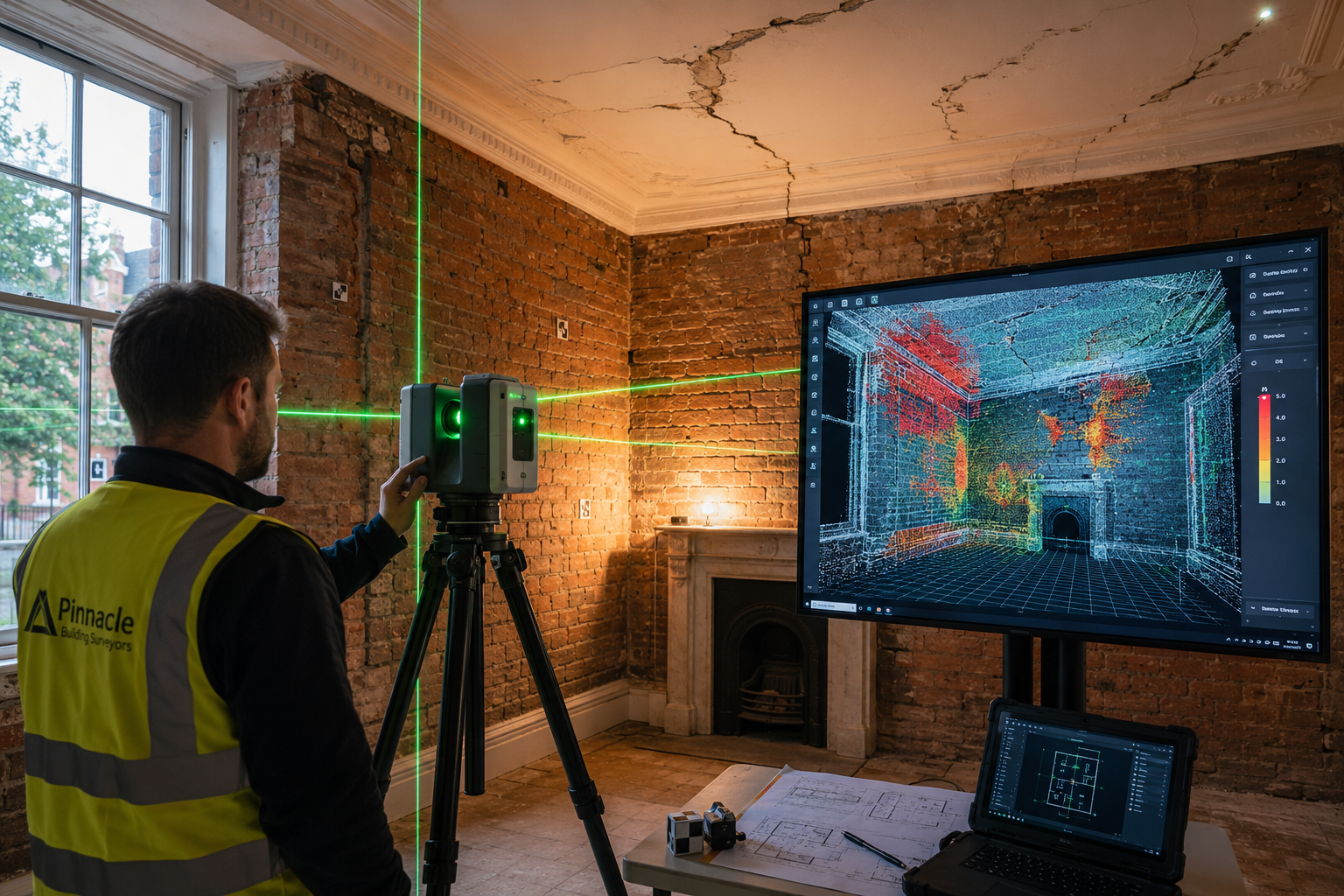
Traditional building surveys rely on a surveyor's trained eye, a damp meter, and written notes. That approach remains valuable, but it produces a flat, text-based report that many buyers struggle to translate into a clear picture of risk. 3D laser scanning changes the medium entirely.
A terrestrial laser scanner emits millions of laser pulses per second, measuring the precise distance to every surface it hits. The result is a point cloud — a dense, three-dimensional map of the building's interior and exterior composed of hundreds of millions of data points. When processed, this point cloud becomes a navigable 3D model accurate to within a few millimetres.
What the Technology Captures
| Feature | Traditional Survey | 3D Laser Scan Survey |
|---|---|---|
| Wall alignment and verticality | Estimated visually | Measured to millimetre accuracy |
| Floor deflection and level | Noted if obvious | Quantified across entire floor plane |
| Roof geometry and deformation | Inspected from below | Mapped in full 3D profile |
| Hidden voids or structural gaps | Not detectable | Identifiable via scan anomalies |
| As-built documentation | Sketch or photo | Full dimensional record [3] |
For buyers considering older or complex properties, this level of detail is transformative. A Level 3 Full Building Survey already provides the most thorough written assessment available, but when combined with 3D scanning, it delivers a spatial record that supports every written observation with measurable evidence.
High-resolution 3D models have been shown to reveal hidden structural issues — including misaligned floors and outdated structural elements — that allow for early identification and informed repair strategies. [4] This is particularly relevant in period properties where settlement, subsidence, and decades of ad hoc repairs create complex defect patterns.
Drone Surveys: Extending 3D Modeling to Roofs and Facades
One of the most significant limitations of any ground-based survey is access. Roofs, high-level facades, chimney stacks, and parapet walls are difficult or impossible to inspect safely from ground level. This is where drone technology closes the gap.
Professional-grade survey drones equipped with high-resolution cameras and LiDAR sensors can map a roof surface in minutes, producing photogrammetric 3D models accurate enough to identify cracked ridge tiles, sagging roof sections, blocked gutters, and failed flashings. For buyers of properties with complex rooflines — mansard roofs, multi-pitched Victorian terraces, or flat roof extensions — this data is invaluable.
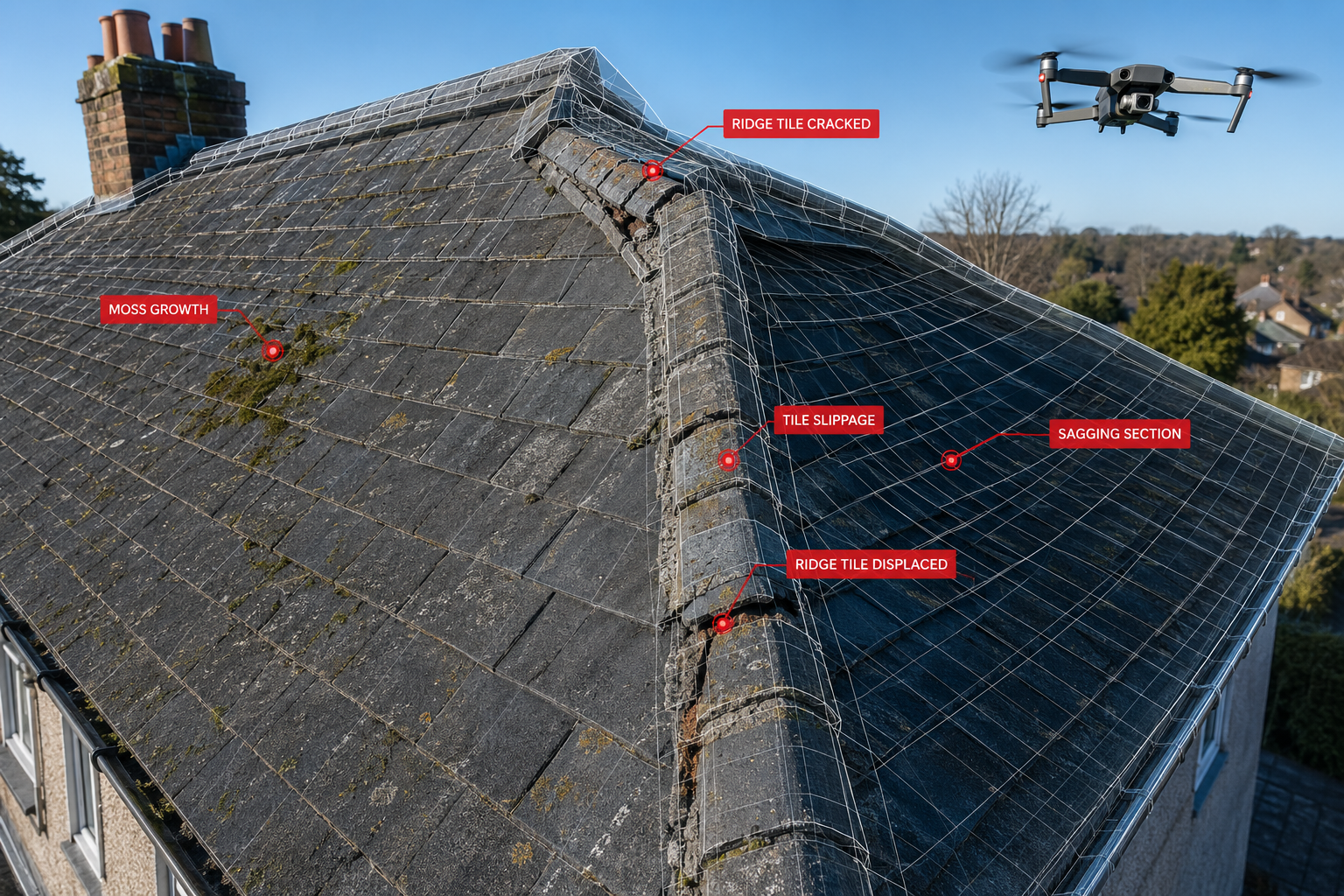
Prince Chartered Surveyors offers premium drone survey services that integrate aerial data directly into building assessments, giving buyers a complete picture of roof condition that would otherwise require expensive scaffold access. Common roof defects — including those detailed in guides on pitched roof types and common defects — become visually undeniable when presented as a 3D model with annotated defect zones.
Why Drone-Generated 3D Data Matters for Negotiation
When a surveyor writes "ridge tiles showing signs of deterioration," a seller can dispute the severity. When a buyer presents a drone-generated 3D model showing 14 displaced ridge tiles across a 12-metre ridge line, with photographic overlays and dimensional measurements, the conversation changes. The evidence is objective, spatial, and difficult to dismiss.
3D visualization reduces commercial and residential construction risk by making unclear decisions visible before work starts, supporting earlier agreement around scope and budget exposure. [5] In a purchase negotiation, that same principle applies: clarity of evidence drives clarity of outcome.
Defect Visualization: Turning Survey Findings Into Actionable Intelligence
The core value proposition of 3D Modeling in Building Surveys: Enhancing Defect Visualization and Negotiation Power for 2026 Buyers lies in communication. A 40-page written survey report, however thorough, requires the reader to mentally construct the building and locate each defect within it. A 3D model does that work automatically.
How 3D Models Communicate Defects More Effectively
Color-coded severity mapping allows defects to be categorized visually — red for urgent structural issues, amber for items requiring monitoring, green for minor maintenance. A buyer can rotate the model on a tablet, zoom into a specific wall junction, and immediately understand the relationship between a crack in the external render and the internal damp patch two rooms away.
This spatial relationship is critical. Building pathology — the study of how building defects develop and interact — often involves chains of cause and effect that span multiple elements. A 3D model makes those chains visible in a way that text descriptions cannot replicate.
Research has consistently shown that 3D visualizations prevent misunderstandings and increase coordination efficiency, particularly in complex projects. [2] For property buyers, this translates directly: when a buyer, their solicitor, and their contractor are all looking at the same 3D model, the risk of misinterpretation drops significantly.
Quantified defect data is another major advantage. Rather than describing a floor as "noticeably uneven," a laser scan survey can report a maximum deflection of 28mm over a 4-metre span, with a gradient map showing the full extent of the problem. That kind of precision supports accurate repair cost estimates, which in turn supports a specific, justified price reduction request.
For buyers wanting to understand how survey findings translate into negotiation outcomes, the average price reduction after a survey provides useful context on what buyers typically achieve and how defect evidence shapes those conversations.
The Negotiation Advantage: Using 3D Survey Data to Strengthen Your Position
Negotiating a price reduction after a building survey is one of the most financially significant conversations a buyer will have. The strength of that negotiation depends almost entirely on the quality of the evidence presented.

Building a Evidence-Based Case
A 3D survey model supports negotiation in three specific ways:
-
Objectivity: Dimensional data is not a matter of opinion. A wall leaning 45mm out of plumb at 3 metres height is a measurable fact, not an interpretation.
-
Completeness: A full 3D scan of the property creates a comprehensive record that is difficult for sellers or their agents to selectively challenge. Every surface has been measured.
-
Cost correlation: When defect data is precise, contractor quotes become more accurate. A buyer who presents a £18,500 structural repair quote backed by millimetre-accurate 3D scan data is in a far stronger position than one presenting a vague estimate.
Investing in high-quality pre-construction 3D rendering and scanning has been shown to save approximately five dollars in rework costs for every dollar spent. [1] For buyers, the equivalent logic applies: the cost of a 3D-enhanced survey is typically a fraction of the negotiation saving it enables.
Practical Negotiation Steps
- Commission a RICS building survey that incorporates 3D scanning or drone data from the outset.
- Request that the surveyor's report cross-references written findings with specific locations in the 3D model.
- Share the 3D model with at least two contractors before making a price reduction request, so repair estimates are based on the same spatial data.
- Present the 3D model alongside the written report when submitting a formal renegotiation request to the seller's solicitor.
Understanding the consequences of failing to act on survey findings is equally important — buyers who proceed without addressing identified defects can face significantly higher remediation costs post-completion.
Digital Twins and the Future of Building Survey Intelligence
3D models produced during a building survey do not have to be a one-time snapshot. They can serve as the foundation for a digital twin — a continuously updated virtual replica of the building that monitors structural performance, environmental conditions, and maintenance needs in real time. [4]
For 2026 buyers of larger residential or commercial properties, this represents a significant shift in how building ownership is managed. A digital twin built on laser scan survey data can:
- Track crack propagation over time by comparing new scans against the baseline survey model
- Alert owners to deviations in structural geometry that may indicate ongoing movement
- Support insurance claims with precise, time-stamped spatial records
- Inform planned maintenance schedules with accurate dimensional data
3D laser scanning also enables detailed building analysis including assessments of deformations, flatness, and verticality — providing insights that support both immediate decision-making and long-term asset management. [7]
For buyers considering properties that will require renovation or extension, a measured survey based on 3D scan data provides the accurate dimensional foundation that architects and structural engineers need to design works correctly from day one. Errors in as-built dimensions are a leading cause of costly design revisions — a problem that precise 3D documentation eliminates. [3]
3D Scanning and Specialist Assessments
3D modeling integrates naturally with specialist survey components. When asbestos building surveys are required, a 3D model of the property allows asbestos-containing materials to be precisely located within the building's spatial context, making management plans and remediation scopes far more actionable.
Similarly, building materials assessments benefit from 3D context — understanding not just what a material is, but exactly where it sits within the building's structure and how it interacts with adjacent elements.
Choosing the Right Survey for 3D-Enhanced Defect Analysis
Not all surveys include 3D modeling as standard. Buyers need to understand what they are commissioning and whether the level of survey matches the complexity of the property.
| Survey Level | Typical Use | 3D Modeling Relevance |
|---|---|---|
| Level 1 (Condition Report) | New builds, straightforward properties | Low — basic condition only |
| Level 2 (Homebuyer Report) | Standard residential properties | Moderate — limited defect depth |
| Level 3 (Full Building Survey) | Older, complex, or high-value properties | High — full defect analysis, ideal for 3D integration |
For most buyers considering 3D-enhanced surveys, a Level 3 Full Building Survey is the appropriate foundation. Understanding the difference between Level 2 and Level 3 surveys helps buyers make an informed choice based on property age, construction type, and risk profile.
Practitioners across the construction and surveying sectors show a strong preference for 3D digital information over traditional 2D documentation, recognizing its superior capacity for field interpretation and decision support. [6] As this preference becomes mainstream, buyers who commission 3D-enhanced surveys will be better equipped than those relying on conventional reports alone.
Conclusion
3D Modeling in Building Surveys: Enhancing Defect Visualization and Negotiation Power for 2026 Buyers represents a genuine step change in how property risk is assessed, communicated, and acted upon. Laser scanning and drone technology have moved from specialist tools to practical survey instruments, producing interactive models that make structural defects spatially undeniable and financially quantifiable.
For buyers in 2026, the actionable steps are clear:
- Specify 3D scanning or drone survey integration when commissioning a Level 3 Full Building Survey on any property built before 1980 or with complex roof geometry.
- Use the 3D model as a negotiation document — share it with contractors, solicitors, and the seller's agent as objective, dimensional evidence.
- Consider the digital twin potential of your survey data for long-term asset management, particularly for larger or investment properties.
- Do not proceed without acting on findings — the consequences of ignoring survey evidence are well-documented and financially serious.
The buyers who will negotiate most effectively in 2026 are those who treat their survey not as a formality, but as a precision instrument for protecting their investment.
References
[1] How 3d Rendering Catches Design Flaws Before You Break Ground – https://architectengineer.cr/how-3d-rendering-catches-design-flaws-before-you-break-ground/?utm_source=openai
[2] Empirically Validating Five Propositions Regarding 3d Visualizati – https://research.utwente.nl/en/publications/empirically-validating-five-propositions-regarding-3d-visualizati/?utm_source=openai
[3] existingconditions – https://www.existingconditions.com/?utm_source=openai
[4] Why Every Building Survey Should Include A 3d Model – https://www.lnesurveys.com/blog/2025/4/29/why-every-building-survey-should-include-a-3d-model?utm_source=openai
[5] How 3d Visualization Reduces Commercial Construction Risk – https://ccr-people.com/vendor-news/how-3d-visualization-reduces-commercial-construction-risk/?utm_source=openai
[6] S40327 014 0009 8 – https://link.springer.com/article/10.1186/s40327-014-0009-8?utm_source=openai
[7] Building Analysis – https://www.pointspace.ca/services/building-analysis?utm_source=openai
[8] Clash Detection – https://www.gp-radar.com/3d-laser-scanning/clash-detection?utm_source=openai