By December 2024, the USDA confirmed that 68% of large crop farms — those generating over $1 million in annual income — were already using precision agriculture technologies, with adoption rates climbing steeply as farm size increases [5]. That figure marks a turning point: the tools once reserved for engineering surveys and land mapping are now reshaping how food is grown. Precision farming, and specifically the expansion of surveying applications into agriculture with drones and GIS, is no longer a niche experiment. It is a mainstream operational strategy that is redefining what it means to manage land productively and sustainably in 2026.
Key Takeaways
- Drone-based aerial surveys and GIS mapping give farmers centimeter-level accuracy in field analysis, replacing slow and costly manual methods.
- USDA data shows 68% of large crop farms now use precision agriculture technologies, with adoption growing across mid-size operations too.
- AI-powered drones can now operate without pre-mapped field data, using real-time vision to guide spraying and surveying tasks.
- GIS platforms integrate drone imagery, satellite data, and soil sensors into unified dashboards that drive variable-rate application decisions.
- Surveying professionals and agronomists are converging on shared tools, creating new career and service opportunities in agricultural surveying.
How Precision Farming and Surveying Converged
For decades, surveying and agriculture operated as separate disciplines. Surveyors mapped land for construction, legal boundaries, and infrastructure. Farmers relied on intuition, soil tests, and seasonal observation. The convergence began quietly, driven by one shared need: accurate spatial data.
Geographic Information Systems (GIS) became the bridge. When GIS platforms started integrating satellite imagery with field-level sensor data, agronomists realized they were working with the same foundational tools that surveyors had used for years — just applied to different problems. Elevation models, contour mapping, drainage analysis, and boundary delineation all translate directly from surveying practice into farm management.
The arrival of affordable commercial drones accelerated this merger dramatically. Unmanned aerial vehicles (UAVs) could now fly over a 500-acre farm in under two hours, capturing high-resolution imagery that, when processed through photogrammetry software, produced the same quality of spatial data as a traditional ground survey — at a fraction of the cost and time.
This is the foundation of precision farming: surveying applications expanding into agriculture with drones and GIS to deliver data-driven decisions at the field level.
What GIS Actually Does on a Farm
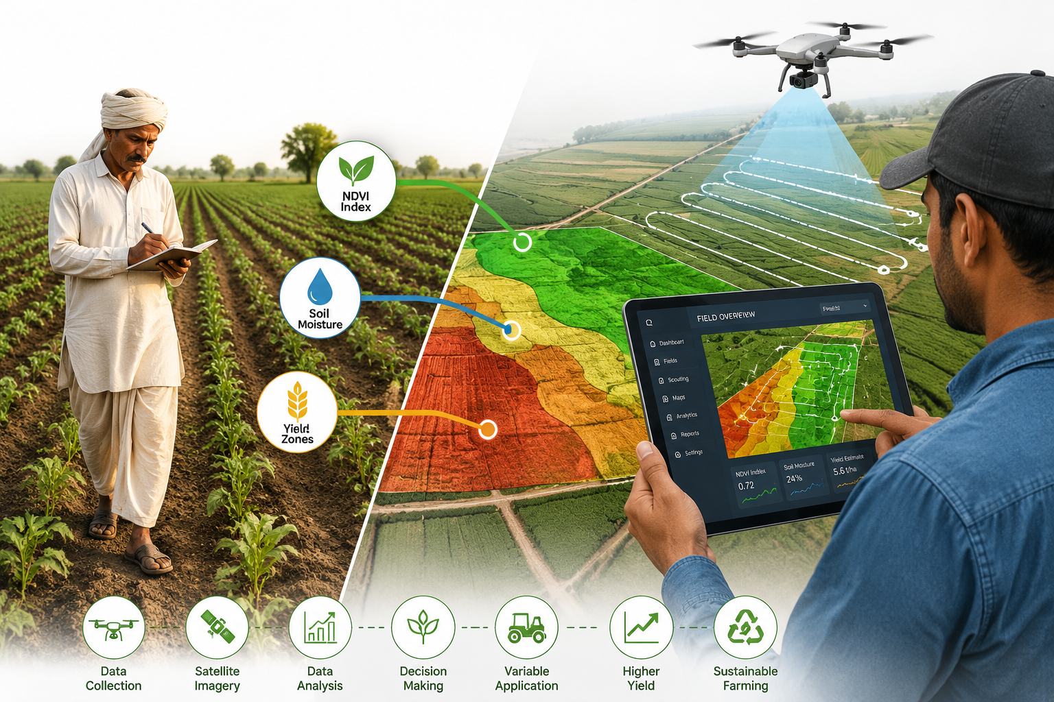
GIS in agriculture is not simply a map viewer. It is an analytical engine that layers multiple data streams — drone imagery, satellite passes, soil sensor readings, weather data, and historical yield records — into a single georeferenced model of the farm.
Key GIS functions in agricultural settings include:
- Normalized Difference Vegetation Index (NDVI) mapping: Identifies crop stress zones by measuring light reflectance differences between healthy and struggling plants.
- Soil variability mapping: Highlights zones of different nutrient levels, pH, and moisture content to guide variable-rate fertilizer application.
- Drainage and topography analysis: Uses elevation data to predict waterlogging, erosion risk, and runoff pathways.
- Yield zone delineation: Combines historical yield data with current season imagery to define management zones for targeted inputs.
Platforms like Pollen Systems' PrecisionView Mobile, demonstrated in 2023 as an Esri Business Partner solution, integrate aerial imagery from both drones and satellites with mobile field data to give farmers advanced analytics directly on a handheld device [4]. The result is that a farmer walking a field can access the same layered spatial intelligence that a GIS analyst would review in an office.
Drone Technology Driving Agricultural Surveying Forward
The drone market for agriculture has evolved far beyond simple aerial photography. In 2026, the most capable agricultural UAVs combine RTK (Real-Time Kinematic) positioning, multispectral sensors, AI-driven image analysis, and autonomous flight planning into a single platform. Understanding how these components work together explains why precision farming and surveying applications are expanding so rapidly.
RTK Positioning and Centimeter-Level Accuracy
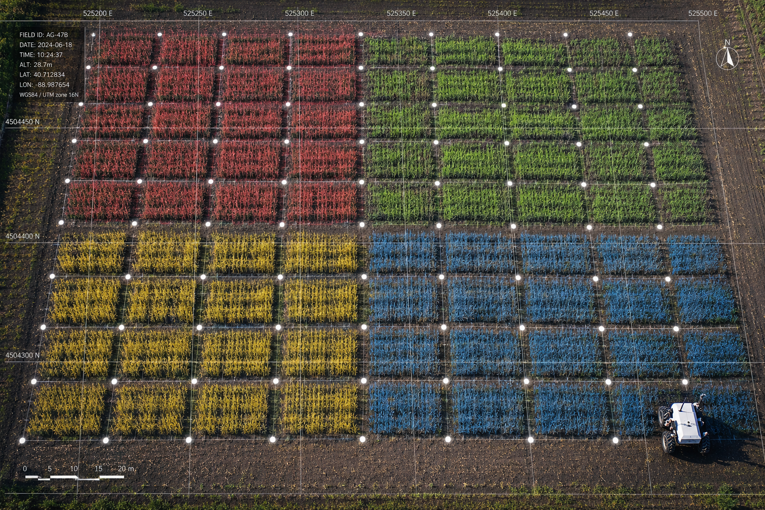
RTK GPS is the same positioning technology used in professional land surveying. It corrects satellite signal errors in real time by referencing a fixed ground station, achieving positional accuracy of 1–3 centimeters. When applied to agricultural drones, RTK means that every image captured is georeferenced to an exact location on the earth's surface.
This matters enormously for repeat surveys. A drone flight in April and another in July will produce imagery that can be compared pixel-by-pixel because both datasets share the same coordinate reference. Crop growth, soil change, and pest damage can be tracked with precision that was previously impossible without expensive ground-based equipment.
In April 2026, DroneDash Technologies and GEODNET launched GEODASH Aerosystems, introducing agricultural spraying drones that combine real-time AI vision with centimeter-accurate RTK positioning. Critically, this system eliminates the need for repeated manual pre-mapping of fields — the drone navigates and responds to its environment in real time, dramatically reducing setup time for large-scale operations [1].
Autonomous Operations and AI-Powered Analysis
Autonomy is the next frontier. In June 2026, autonomous drones began operations at North Carolina's Sandhills Research Station, launched remotely from North Carolina State University. These drones independently survey research plots, capturing high-resolution images to support data-driven, sustainable farming practices — without a pilot physically present at the site [2].
A November 2024 study published in the journal Drones highlighted the transformative impact of integrating UAVs with AI and machine learning in precision agriculture. The combination supports real-time crop health monitoring and automated decision-making, improving both productivity and resource efficiency [7]. AI algorithms can now identify individual weed species, detect early-stage disease outbreaks, and estimate crop biomass from drone imagery — tasks that previously required trained agronomists walking fields for days.
Ground-Based Robots Complement Aerial Surveys
Aerial drones excel at broad-area mapping, but some surveying tasks require closer contact with the ground. In January 2026, TerraClear introduced the TerraScout, an autonomous ground-based robot designed for precision mapping of weeds and rocks. Powered by a 48-horsepower diesel engine, the TerraScout captures high-resolution field images at ground level, providing complementary data to aerial surveys for more complete field management [3].
A 2023 study published on arXiv introduced an autonomous hybrid drone-rover vehicle designed for weed removal and spraying applications, combining the wide-area coverage of drones with the precision of ground robots [10]. These hybrid systems represent the next generation of agricultural surveying platforms.
Variable-Rate Application: Turning Maps into Action
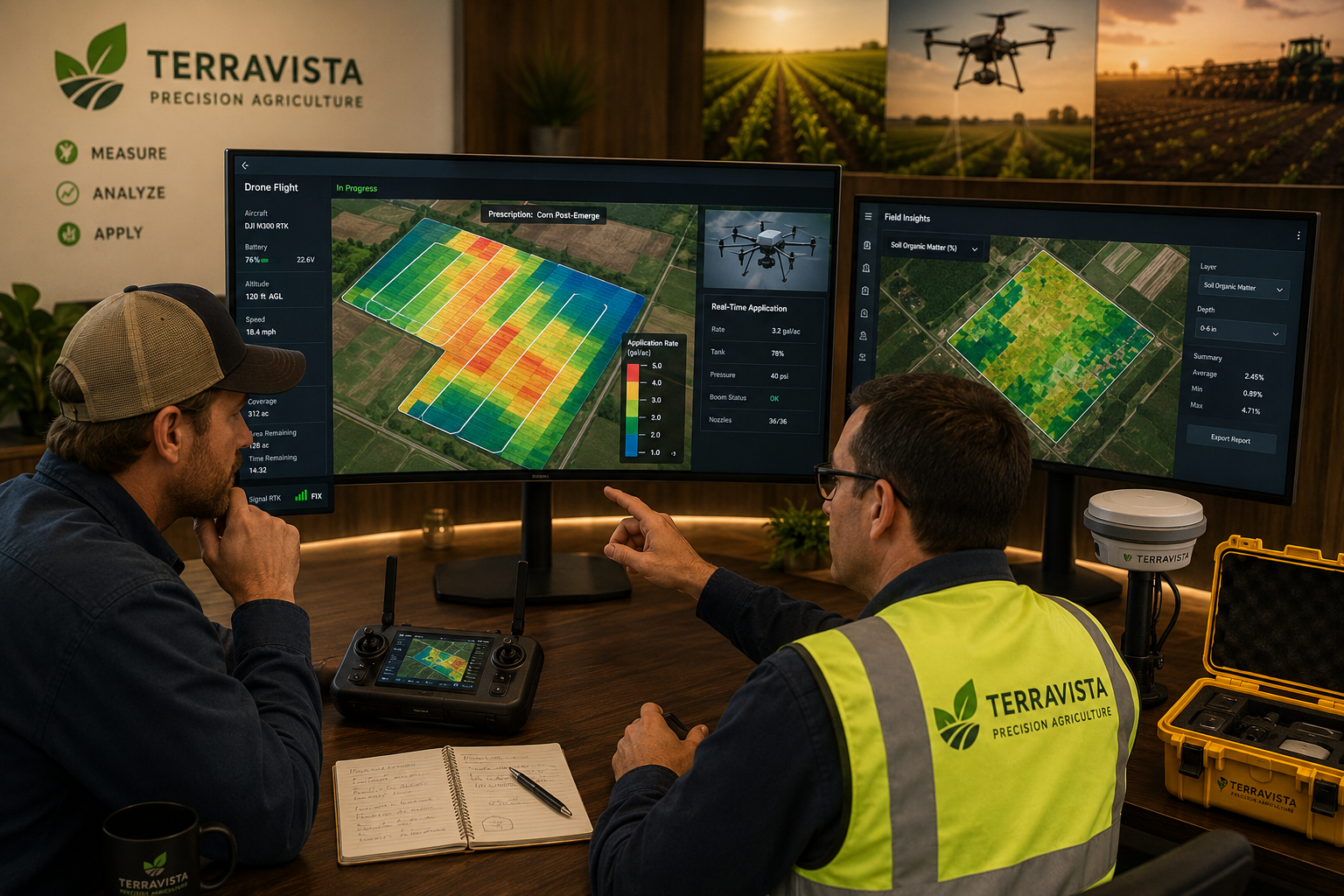
Surveying data has no value unless it drives decisions. Variable-rate application (VRA) is the mechanism that converts GIS maps into physical actions — adjusting the rate of fertilizer, pesticide, or seed applied to different zones of a field based on the spatial data collected.
In October 2024, XAG partnered with PIX4D to introduce a prescription map feature for agricultural drones. This feature enables variable-rate application of crop protection products, fertilizers, and seeding, allowing farmers to apply more inputs where soil data indicates deficiency and less where conditions are already optimal [6]. The partnership was further expanded in May 2025, with enhanced drone mapping tools designed to provide farmers with data-backed, precision-driven crop solutions [9].
| Technology | Primary Function | Key Benefit |
|---|---|---|
| RTK GPS Drone | Georeferenced aerial imagery | Centimeter-level field mapping |
| Multispectral Camera | NDVI and crop health analysis | Early stress detection |
| GIS Platform | Data integration and analysis | Unified field intelligence |
| Prescription Maps | Variable-rate application | Reduced input waste |
| Ground Robots | Close-range weed and soil mapping | Complements aerial data |
Practical Setup, Farmer Success, and the Surveying Connection
Understanding the technology is one thing. Implementing it on a working farm requires a practical framework. The following guidance reflects how precision farming surveying applications are being deployed successfully in 2026.
Getting Started: A Practical Tech Stack
A functional precision farming setup does not require purchasing every available tool at once. A phased approach works well:
Phase 1 — Aerial Data Collection
Begin with a commercial agricultural drone equipped with an RGB camera and RTK GPS. This alone enables field boundary mapping, crop scouting, and basic NDVI analysis when combined with the right software. Drone survey principles share significant overlap with the methods used in premium drone surveys for buildings and land, where accurate georeferencing and systematic flight planning are equally critical.
Phase 2 — GIS Integration
Connect drone imagery to a GIS platform. Options range from cloud-based agricultural platforms (such as PIX4Dfields or Esri AgriBusiness) to mobile apps like PrecisionView Mobile. The goal is to move from raw images to actionable spatial layers — NDVI maps, soil variability zones, and drainage models.
Phase 3 — Variable-Rate Application
Once field zones are mapped and understood, connect GIS outputs to farm machinery equipped with variable-rate controllers. Prescription maps generated from drone surveys are uploaded directly to tractor guidance systems, automating input adjustments across the field.
Phase 4 — Monitoring and Iteration
Schedule repeat drone surveys at key crop growth stages — typically at planting, canopy closure, and pre-harvest. Compare datasets across seasons to identify trends, refine management zones, and measure the return on investment from precision inputs.
The Role of Professional Surveyors in Precision Agriculture
The expansion of surveying applications into agriculture creates a genuine opportunity for chartered surveyors and land professionals. Skills in photogrammetry, coordinate systems, elevation modeling, and spatial data management are directly transferable to agricultural drone surveying.
Professionals familiar with measured building surveys and measured surveys more broadly will recognize the core methodology: systematic data capture, georeferencing, and the production of accurate spatial outputs for client decision-making. The agricultural context adds complexity around crop biology and agronomy, but the surveying fundamentals remain identical.
Understanding building materials assessments and structural condition reporting also translates into agricultural infrastructure surveys — assessing irrigation systems, grain stores, and farm buildings using drone-based visual inspection alongside traditional survey methods.
Farmer Success: What the Data Shows
The USDA's Economic Research Service reported in December 2024 that 52% of midsize farms and 70% of large-scale crop-producing farms used guidance autosteering systems in 2023 [8]. These numbers reflect a broader pattern: farms that invest in precision technology report measurable gains in input efficiency, yield consistency, and profitability.
Specific benefits documented across precision farming programs include:
- Fertilizer savings of 15–20% through variable-rate application based on soil zone mapping.
- Pesticide reduction of up to 25% when drone-based scouting identifies localized pest pressure rather than triggering field-wide spray programs.
- Water use efficiency improvements when GIS-derived drainage and soil moisture maps inform irrigation scheduling.
- Labor cost reductions as autonomous drones replace manual scouting across large acreages.
The convergence of land surveying expertise with agricultural data needs is also creating new service models. Surveying firms are expanding into agricultural drone survey contracts, offering farmers the same rigorous spatial data quality that construction and property clients have relied on for decades. For those interested in understanding how professional survey services are structured and delivered, resources on what questions to ask during a building survey offer useful insight into the quality standards that translate across survey disciplines.
Regulatory and Operational Considerations
Deploying drones for agricultural surveying requires compliance with national aviation authority regulations. In the UK, this means adhering to Civil Aviation Authority (CAA) rules on drone registration, operator certification, and flight restrictions near populated areas. In the US, FAA Part 107 certification governs commercial drone operations.
Key operational considerations include:
- Flight planning software: Tools like PIX4D, DroneDeploy, or Mission Planner automate waypoint planning for systematic field coverage.
- Ground control points (GCPs): Placing physical markers with known GPS coordinates across a field improves the absolute accuracy of photogrammetric outputs.
- Data storage and processing: High-resolution multispectral surveys generate large datasets. Cloud processing platforms reduce the computational burden on local hardware.
- Insurance and liability: Agricultural drone surveys may require specialist insurance coverage, particularly when operating over livestock or near farm infrastructure.
Professionals exploring how survey services are structured across different asset types will find parallels in resources covering building survey timeframes and project management in complex survey environments.
Conclusion
Precision farming and the expansion of surveying applications into agriculture with drones and GIS represent one of the most significant shifts in land management practice in a generation. The tools are proven, the adoption data is compelling, and the operational frameworks are mature enough for farms of almost any scale to implement.
Actionable next steps for farmers and land professionals in 2026:
- Audit current data gaps: Identify which field-level decisions are currently made without spatial data — soil variability, crop stress, drainage — and prioritize those areas for drone survey investment.
- Start with a pilot area: Run a single-season precision survey program on a defined field section before scaling across the entire operation. Measure input savings and yield outcomes rigorously.
- Engage a qualified surveyor: Chartered surveyors with drone and GIS expertise can deliver agricultural surveys to the same accuracy standards used in property and construction — a quality level that most farm-level drone operators do not match.
- Integrate GIS with existing farm management software: Most modern farm management platforms accept GIS-compatible prescription map files. Connecting spatial data to machinery guidance systems is the step that converts maps into measurable savings.
- Plan for repeat surveys: A single drone flight is useful. A series of georeferenced flights across multiple seasons is transformative. Build repeat surveying into the annual farm management calendar.
The boundary between land surveying and agricultural management is dissolving. For professionals and farmers willing to work at that intersection, the opportunity to improve productivity, reduce environmental impact, and build more resilient farming systems has never been greater.
References
[1] Dronedash And Geodnet Launch Geodash Aerosystems To Bring Map Free Ai Driven Precision Spraying To Industrial Agriculture – https://www.businesswire.com/news/home/20260414902513/en/DroneDash-and-GEODNET-Launch-GEODASH-Aerosystems-to-Bring-Map-Free-AI-Driven-Precision-Spraying-to-Industrial-Agriculture?utm_source=openai
[2] Autonomous Drones And Ai Powered Data Collection Are Shaping The Future Of Precision Agriculture – https://www.global-agriculture.com/mechanization-technology/autonomous-drones-and-ai-powered-data-collection-are-shaping-the-future-of-precision-agriculture/?utm_source=openai
[3] Terraclear Autonomous Crop Scout Ai Weed Mapping Robot – https://www.terraclear.com/company-news/terraclear-autonomous-crop-scout-ai-weed-mapping-robot/?utm_source=openai
[4] Esri Partner Pollen Systems Provides Advanced Agriculture Analytics To Farms Using Precisionview Mobile – https://www.businesswire.com/news/home/20230309005057/en/Esri-Partner-Pollen-Systems-Provides-Advanced-Agriculture-Analytics-to-Farms-using-PrecisionView-Mobile?utm_source=openai
[5] The Usda Reports 68 Of Large Crop Farms Use Precision Ag Technology – https://www.proag.com/news/the-usda-reports-68-of-large-crop-farms-use-precision-ag-technology/?utm_source=openai
[6] xa – https://xa.com/en/news/official/xag/213?utm_source=openai
[7] mdpi – https://www.mdpi.com/2504-446X/8/11/664?utm_source=openai
[8] Chart Detail – https://ers.usda.gov/data-products/charts-of-note/chart-detail?chartId=110550&utm_source=openai
[9] Xag And Pix4d Advancing Precision Agriculture With Powerful Drone Mapping Tools – https://www.fairlifts.com/uav/xag-and-pix4d-advancing-precision-agriculture-with-powerful-drone-mapping-tools/?utm_source=openai
[10] arxiv – https://arxiv.org/abs/2308.04794?utm_source=openai