A field that looks uniformly green to the naked eye can be silently losing 30% of its productive capacity to subsurface drainage failures, nutrient depletion, or hidden contamination — none of which a standard site walkthrough will ever reveal. This is precisely the gap that multispectral sensors in drone surveys are closing for 2026 property evaluations, transforming how surveyors, developers, and landowners understand what lies beneath the surface before a single planning application is submitted.
As agricultural land conversions, rural development projects, and mixed-use site assessments accelerate across the UK, the demand for pre-development intelligence has never been sharper. Multispectral drone surveys now sit at the intersection of precision agriculture and professional property evaluation, delivering data layers that thermal imaging alone cannot provide and that traditional soil sampling cannot match in speed or spatial coverage.
Key Takeaways
- Multispectral sensors capture light beyond the visible spectrum, enabling detection of soil health issues, vegetation stress, and subsurface anomalies invisible to standard cameras.
- Combining multispectral and thermal data produces a far more complete picture of site viability, particularly for agricultural conversions and pre-development assessments.
- Indices such as NDVI and NDRE translate raw spectral data into actionable maps that inform property valuations, planning decisions, and remediation budgets.
- 2026 sensor technology — including six-band multispectral systems — now delivers agronomically precise data at a resolution suitable for individual property parcels.
- Integrating drone survey findings with a professional building or land survey strengthens due diligence and can directly influence negotiated property prices.
How Multispectral Sensors Work and Why They Matter for Property Surveys
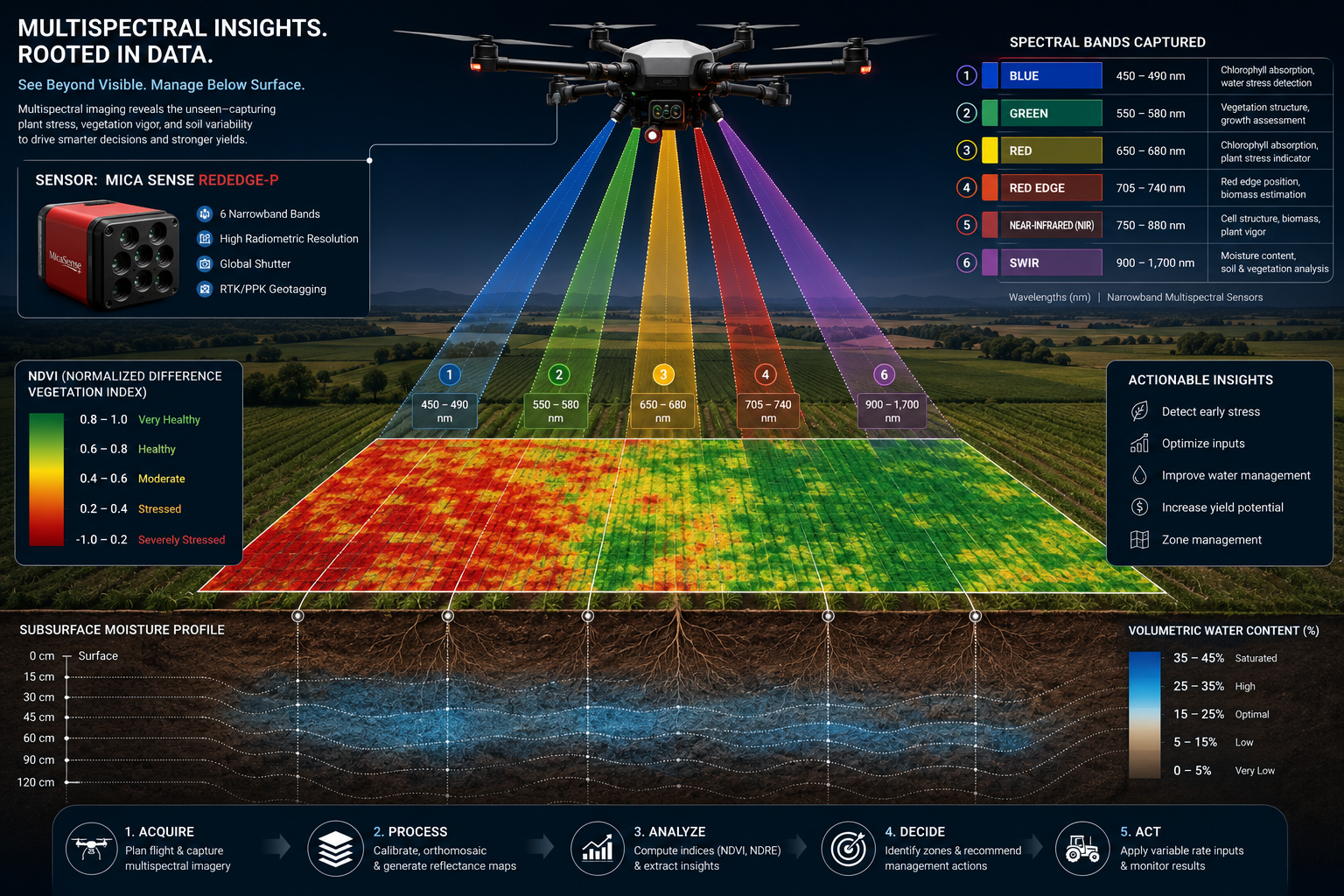
Standard RGB cameras record only the red, green, and blue wavelengths that human eyes detect. Multispectral sensors go further, capturing additional bands — most critically Near-Infrared (NIR) and Red Edge — that reveal how plants and soils are actually functioning rather than simply how they appear. Healthy vegetation absorbs red light for photosynthesis and reflects NIR strongly; stressed or dying vegetation does the opposite. This physiological response forms the scientific basis for indices such as the Normalised Difference Vegetation Index (NDVI) and the Normalised Difference Red Edge index (NDRE).
The Sentera 6X Multispectral Sensor, introduced in April 2026, captures six discrete spectral bands simultaneously, enabling detailed NDVI and NDRE mapping that delivers agronomically actionable data at the scale of individual property parcels [2]. Systems such as the Micasense Altum go further still, combining multispectral capture with thermal infrared in a single flight, providing simultaneous surface temperature and vegetation stress data [8]. Meanwhile, the HyperSlit sensor platform supports map-based spectral analysis across agriculture, water, soil, and environmental monitoring, enabling detailed assessments of soil variability and plant health from a single instrument [6].
For property professionals, what this means in practical terms is straightforward: a drone equipped with a multispectral sensor can survey a 50-hectare site in a single flight and return georeferenced maps showing exactly where soil moisture is deficient, where nutrient stress is concentrated, and where drainage anomalies suggest subsurface issues. This is data that would take weeks and thousands of pounds to gather through conventional soil sampling grids.
Key Spectral Indices Used in Property and Land Assessments
| Index | Bands Used | What It Reveals |
|---|---|---|
| NDVI | Red, NIR | General vegetation vigour and biomass |
| NDRE | Red Edge, NIR | Chlorophyll content, early nutrient stress |
| NDMI | NIR, SWIR | Canopy moisture and drought stress |
| SAVI | Red, NIR | Vegetation density on exposed or sparse soils |
| Thermal Composite | Thermal IR + NDVI | Surface temperature anomalies, drainage, compaction |
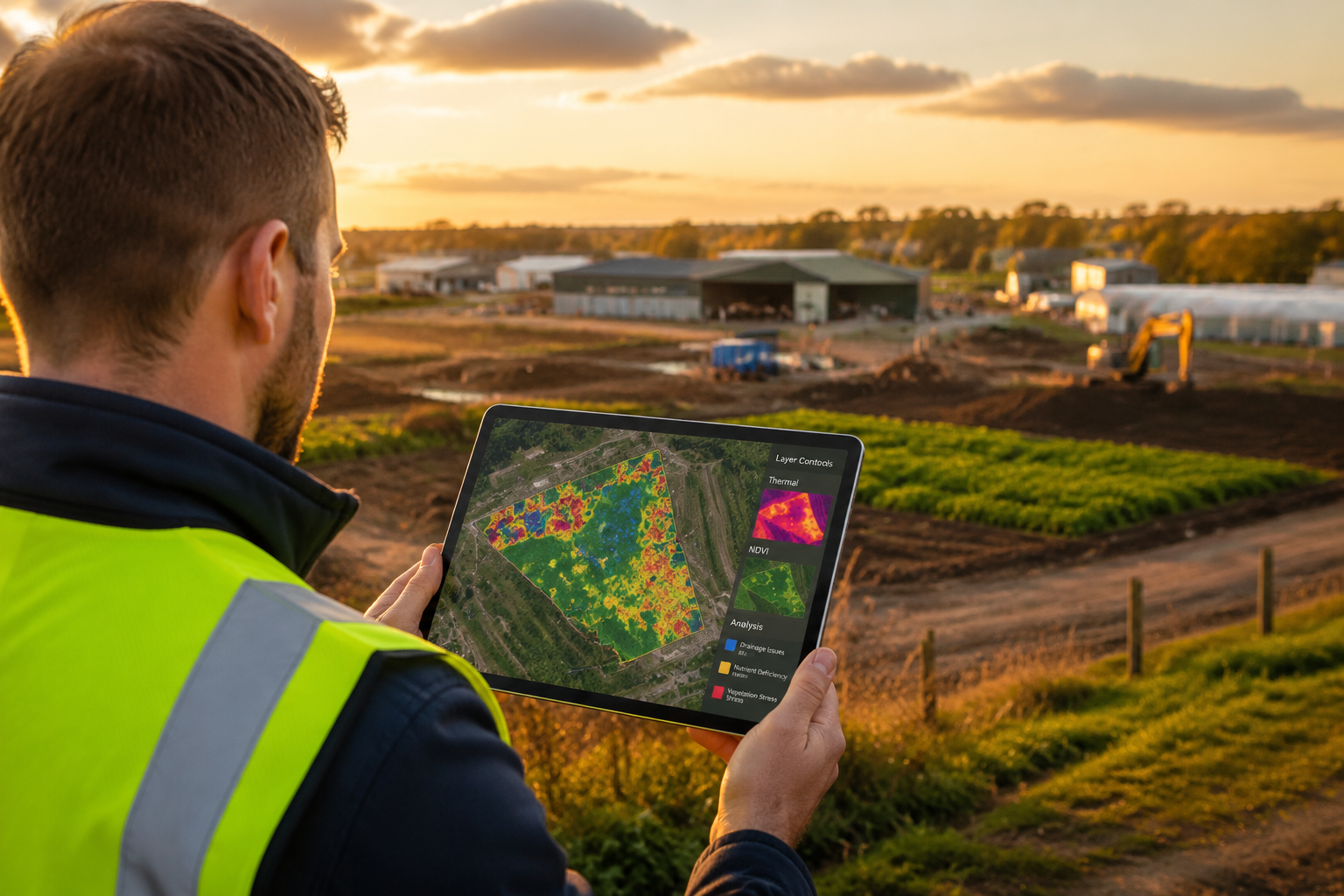
Each of these indices translates raw spectral reflectance data into a colour-coded map that a surveyor, land agent, or developer can interpret without specialist remote sensing training. The maps are typically overlaid on site plans or integrated into GIS platforms, making them directly compatible with the outputs of a measured building survey or a full land boundary assessment.
Revealing Soil Health and Vegetation Stress: The Data Behind 2026 Property Evaluations
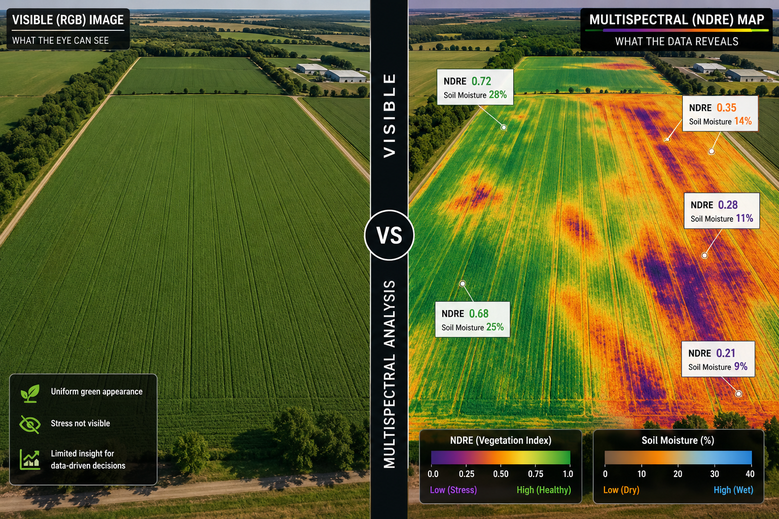
The core value proposition of multispectral sensors in drone surveys for 2026 property evaluations lies in their ability to surface problems that would otherwise only emerge after purchase — or after development has already begun.
Soil Moisture and Drainage Mapping
A 2025 study validated the use of UAV-mounted microwave radiometry for high-resolution soil moisture observations across diverse land covers, achieving unbiased root-mean-square errors below 0.04 m³/m³ [4]. This level of precision means that a drone survey can reliably distinguish between a field with adequate moisture retention and one with chronic drainage failures — a distinction worth tens of thousands of pounds in remediation costs on any agricultural conversion project.
Poor drainage is one of the most common hidden defects on development sites. It drives foundation design complexity, increases groundwork costs, and can render certain areas of a site undevelopable without significant intervention. When this information is captured before heads of terms are agreed, it becomes a powerful negotiating tool. Understanding how building pathology intersects with ground conditions is essential for any pre-purchase due diligence.
Nutrient Deficiency and Soil Variability
Research published in January 2025 demonstrated that combining drone-based multispectral data with soil properties effectively identifies drought-prone areas and monitors crop health, supporting improved farm planning and site assessment [1]. When applied to property evaluations, this means a buyer or developer can receive a spatial map of nutrient variability across a site — identifying zones of phosphorus deficiency, potassium imbalance, or pH extremes — before commissioning expensive laboratory soil testing across the entire area.
Services such as Siora combine multispectral satellite and drone imagery with topographic data and physics-informed modelling to deliver high-resolution nutrient maps and statistical analyses for comprehensive soil health assessments [9]. This approach dramatically reduces the cost and time of pre-development soil characterisation.
Vegetation Stress as a Proxy for Subsurface Conditions
"Vegetation stress patterns visible in multispectral data often map directly onto subsurface anomalies — from buried infrastructure to contaminated ground — making drone surveys a first-line screening tool for site viability."
Companies such as Pacific Fieldworks have demonstrated that drones equipped with multispectral sensors can detect issues including reduced vigour, nutrient imbalance, and water stress before they become visible to the naked eye, enabling earlier and more cost-effective intervention [5]. In a property evaluation context, these same stress signatures can indicate buried rubble, hydrocarbon contamination, or historical land uses that affect development potential.
Multispectral surveys are also applied in archaeology, where they detect sub-surface features with archaeological potential even beneath growing crops [10]. This cross-disciplinary application underlines a critical point for developers: what the sensor sees in the vegetation canopy is frequently a direct reflection of what is happening in the soil profile below.
The Cost-Effectiveness Argument
Research from May 2025 indicates that UAV-based RGB imaging can offer performance comparable to multispectral indices in vegetation health assessment for certain applications, providing a cost-effective alternative for large-scale monitoring [3]. However, for the precision required in formal property evaluations — particularly where legal, financial, or planning decisions depend on the findings — full multispectral capture with dedicated NIR and Red Edge bands remains the professional standard. The marginal cost difference between RGB and multispectral drone surveys is typically small relative to the value of the decisions being made.
Integrating Thermal and Multispectral Data for Pre-Development Site Viability
The most powerful application of multispectral sensors in drone surveys for 2026 property evaluations is not the use of either technology in isolation, but the fusion of multispectral and thermal data into a composite site intelligence layer.
What Thermal Data Adds
Thermal infrared sensors measure surface temperature variation across a site. On their own, thermal maps reveal evapotranspiration differences, surface moisture anomalies, and structural heat loss from buildings. Combined with NDVI or NDRE maps, thermal data creates a far richer diagnostic picture:
- Drainage anomalies: Areas of persistent surface cooling often indicate waterlogged ground or subsurface water movement.
- Compaction zones: Compacted soils retain heat differently from well-structured soils, creating detectable thermal signatures.
- Buried infrastructure: Pipes, tanks, and former foundations create thermal contrasts that appear as geometric anomalies in the data.
- Contamination indicators: Certain contaminants alter soil thermal properties and vegetation response simultaneously, making the combined spectral-thermal signature more diagnostic than either alone.
For agricultural conversions — a growing category of development in 2026 as planning policy continues to evolve — this combined data layer is invaluable. A site that appears viable from road level may show clear evidence of former industrial use, failed drainage infrastructure, or soil compaction from heavy machinery, all of which affect budgeting for repairs and restoration and the overall development appraisal.
Workflow for a Pre-Development Multispectral Survey
A professional multispectral drone survey for property evaluation typically follows this sequence:
- Flight planning: Define survey area, set ground sampling distance (typically 5-10 cm/pixel for property work), and schedule flight during optimal solar conditions.
- Calibration: Capture reflectance calibration panel data before and after each flight to ensure radiometric accuracy.
- Data capture: Fly the site with multispectral and thermal sensors simultaneously where possible.
- Photogrammetric processing: Generate orthomosaics, digital surface models, and spectral index maps using specialist software.
- Interpretation: Overlay spectral maps on site plans, identify anomaly zones, and cross-reference with historical land use data.
- Reporting: Produce a georeferenced report with annotated maps, index values, and recommended follow-up investigations.
This workflow integrates naturally with the outputs of a Level 3 Full Building Survey for sites that include existing structures, creating a unified due diligence package that covers both above-ground condition and below-ground land health.
Environmental Issues and Regulatory Compliance
Environmental due diligence is increasingly embedded in planning requirements and lender conditions. Multispectral drone surveys contribute directly to environmental issues assessments by providing spatial evidence of ground conditions, vegetation health, and potential contamination indicators before intrusive investigation. This can significantly reduce the scope — and therefore cost — of Phase 1 and Phase 2 environmental surveys by focusing attention on the areas where the data suggests problems exist.
For properties where landscaping and land condition directly affect value, the findings of a multispectral survey can also support the case that strategic landscaping investment increases property value by identifying which areas of a site have the soil health to support planting and which require remediation first.
Connecting Survey Data to Property Valuation
The output of a multispectral drone survey is not simply an academic exercise. It feeds directly into the financial analysis that underpins any property transaction. A site with documented drainage failures, nutrient depletion, or contamination indicators carries a measurable discount to its headline value — and having that evidence in a professional survey report provides the basis for negotiation. Understanding the average price reduction after a survey gives buyers and their advisors a realistic framework for applying these findings to offer price adjustments.
For commercial sites and agricultural land, a commercial valuation that incorporates multispectral survey data is considerably more defensible than one based on comparable transactions alone, particularly in a market where ground condition risks are increasingly priced by lenders and insurers.
Practical Considerations for Commissioning a Multispectral Drone Survey in 2026
Not all drone surveys are equal, and commissioning the right type for a property evaluation requires understanding several key variables.
Sensor Selection
The choice of sensor depends on the specific questions the survey needs to answer:
- Six-band multispectral sensors (such as the Sentera 6X) are suited to detailed NDVI and NDRE mapping for agricultural and mixed-use sites [2].
- Multispectral plus thermal combinations (such as the Micasense Altum) are optimal for pre-development viability assessments where subsurface anomaly detection is a priority [8].
- Hyperspectral sensors offer even greater spectral resolution for specialist applications such as contamination mapping or archaeological investigation [6].
Timing and Conditions
Multispectral surveys produce the most diagnostically useful data when vegetation is actively growing, as stress responses are most pronounced during the growing season. For pre-development assessments, surveys conducted in late spring or early summer typically yield the richest data. Thermal surveys are most effective at dawn or dusk when surface temperature differentials are greatest.
Data Deliverables
A professional survey report should include:
- Georeferenced orthomosaic imagery (RGB and false-colour)
- NDVI, NDRE, and relevant index maps with quantified zone statistics
- Thermal composite maps with anomaly annotations
- Site plan overlay with recommended investigation zones
- Written interpretation by a qualified professional
Regulatory and CAA Compliance
All commercial drone operations in the UK must comply with Civil Aviation Authority regulations, including operator authorisation and, for surveys near congested areas, specific operational approvals. Reputable survey providers will hold the necessary permissions and carry appropriate professional indemnity insurance.
For sites with existing structures, the drone survey findings should be reviewed alongside a building defects survey to ensure that ground condition issues are considered in the context of the structural performance of any buildings on site.
Conclusion
Multispectral sensors in drone surveys are no longer a specialist tool reserved for large agricultural operations. In 2026, they represent a practical, cost-effective, and increasingly expected component of rigorous property evaluations — particularly for agricultural conversions, rural development sites, and any land transaction where ground conditions carry financial or planning risk.
The fusion of multispectral and thermal data creates a pre-development intelligence layer that no walkthrough, desk study, or standard soil sampling programme can replicate at comparable speed or spatial resolution. By revealing soil health, vegetation stress, drainage anomalies, and subsurface indicators before contracts are exchanged, these surveys protect buyers, strengthen valuations, and give developers the confidence to proceed — or the evidence to renegotiate.
Actionable next steps for property professionals and buyers:
- Commission a multispectral drone survey as part of pre-purchase due diligence on any agricultural or mixed-use site above one hectare.
- Ensure the survey includes both multispectral and thermal data capture for maximum diagnostic value.
- Request georeferenced deliverables that can be overlaid directly on site plans and shared with planning consultants, structural engineers, and valuers.
- Use survey findings to inform remediation budgets and, where appropriate, to support price renegotiation with documented evidence.
- Integrate drone survey outputs with a full Level 3 building survey for sites containing existing structures to achieve comprehensive due diligence coverage.
The technology is available, the regulatory framework supports it, and the financial case is clear. For any serious property evaluation in 2026, multispectral drone survey data should be considered a standard input, not an optional extra.
References
[1] S0048969724081646 – https://www.sciencedirect.com/science/article/abs/pii/S0048969724081646?utm_source=openai
[2] Sentera 6x Multispectral Sensor – https://harrisaerial.com/sentera-6x-multispectral-sensor/?utm_source=openai
[3] arxiv – https://arxiv.org/abs/2505.07840?utm_source=openai
[4] arxiv – https://arxiv.org/abs/2506.05572?utm_source=openai
[5] Agriculture – https://www.pacificfieldworks.com/agriculture?utm_source=openai
[6] Hyperslit – https://spectroag.com/hyperslit/?utm_source=openai
[7] Assessing Vegetation Health With Drone Spectral Imaging A Comprehensive Guide – https://aai-drones.com/assessing-vegetation-health-with-drone-spectral-imaging-a-comprehensive-guide/?utm_source=openai
[8] Multispectral Mapping – https://www.droneservicesireland.ie/multispectral-mapping?utm_source=openai
[9] Soil Analysis – https://siora.ai/soil-analysis?utm_source=openai
[10] Multispectral Survey – https://www.sumoservices.com/multispectral-survey?utm_source=openai