Nearly one in three homebuyers in the UK discovers a significant defect only after completing a purchase — a costly surprise that better survey technology could have prevented. The rise of Smarter Visual Surveys: Laser Scanning, Drones, and 3D Models for Homebuyers in 2026 is directly addressing this problem, giving buyers a level of visual clarity that traditional paper-based reports simply cannot match. From autonomous LiDAR drones to millimeter-accurate digital twins, the tools available to surveyors and their clients have transformed what it means to truly "know" a property before signing contracts.
This article explains how these technologies work, how they compare with conventional survey methods, and — most importantly — how homebuyers can use them to prioritize repairs, negotiate prices, and avoid expensive surprises.
Key Takeaways
- Laser scanning, drones, and 3D models now deliver millimeter-level accuracy that traditional visual inspections cannot replicate.
- Digital twins and point cloud data allow buyers to identify defects, measure spaces, and plan repairs remotely before committing to a purchase.
- Drone surveys are especially valuable for roofs, chimneys, and other inaccessible areas that standard surveys may flag only as "areas requiring further investigation."
- Smarter visual surveys complement — rather than replace — a qualified chartered surveyor's professional judgment and written report.
- Buyers who combine advanced visual data with a Level 2 or Level 3 building survey gain the strongest possible evidence base for price negotiation.
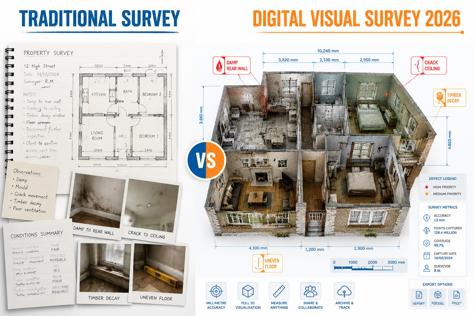
Traditional Surveys vs. Digital Visual Surveys: What Has Changed
For decades, a property survey meant a chartered surveyor visiting a home with a damp meter, a torch, and a notepad. The resulting report described defects in written form, sometimes supported by a handful of photographs. This approach works — qualified surveyors catch serious problems every day using these methods — but it has real limitations.
Written descriptions of visual defects are inherently subjective. A phrase like "minor cracking to the external render" could mean hairline surface shrinkage or the early sign of structural movement. Without a precise measurement or a high-resolution image, a buyer reading that line at home has very little to go on.
Traditional surveys also struggle with access. Roofs, chimney stacks, high parapets, and roof voids are routinely noted as "inspected from ground level only" or flagged as areas of further investigation — meaning the surveyor could not physically reach them. That caveat protects the surveyor professionally, but it leaves the buyer with an incomplete picture.
Digital visual surveys change this in three specific ways:
- Coverage — Drones and laser scanners reach areas no human surveyor can safely access.
- Precision — Point cloud data captures spatial measurements to within a few millimetres, removing ambiguity from defect descriptions.
- Persistence — A 3D model or digital twin can be revisited, measured, and shared indefinitely, unlike a written report that describes a moment in time.
What Traditional Surveys Still Do Better
It is important to be direct here: technology does not replace professional judgment. A drone can photograph a cracked ridge tile, but it cannot tell a buyer whether that crack is cosmetic or whether it reflects a deeper structural issue with the roof structure below. A laser scan can map a wall's geometry to millimeter accuracy, but it cannot interpret what caused a bulge or assess the risk it poses to occupants.
The strongest outcomes come when advanced visual data is combined with expert analysis. Understanding what types of building surveys are available — and choosing the right level — remains the foundation of any sound pre-purchase inspection.
How Laser Scanning, Drones, and 3D Models Work in Practice
LiDAR and Laser Scanning
LiDAR (Light Detection and Ranging) works by firing rapid pulses of laser light at a surface and measuring the time each pulse takes to return. Repeat this millions of times per second across a full building, and the result is a point cloud — a dense three-dimensional map of every surface the laser touched.
Companies such as Aestra3D use LiDAR combined with drone photogrammetry to achieve survey-grade spatial precision across entire buildings [1]. GTEC3D combines aerial and terrestrial scanning to produce high-resolution point clouds alongside 2D CAD drawings and 3D BIM models, reducing the number of site visits needed [2]. The practical output for a homebuyer is a model they can navigate, measure, and annotate from any device.
For properties where accurate floor plans matter — whether for renovation planning, extension applications, or simply verifying the marketed square footage — a measured building survey underpinned by laser scanning data provides a level of accuracy that tape measures and laser distance meters cannot reliably match.
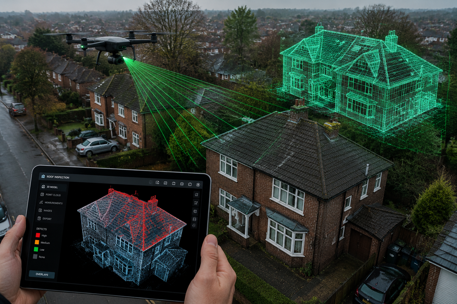
Drone Surveys
Drones equipped with high-resolution cameras and LiDAR sensors can inspect roofs, gutters, chimney stacks, and external walls at close range without scaffolding or access equipment. Leica Geosystems' BLK2FLY is the world's first fully integrated LiDAR UAV, capable of autonomously capturing entire buildings and creating 3D point clouds without a pilot manually directing every flight path [4].
For homebuyers, the most immediate benefit of a drone survey is roof inspection. Pitched roofs are among the most common sources of expensive defects — missing or slipped tiles, failed flashings, blocked gutters, and deteriorating ridge mortar are all difficult or impossible to spot from ground level. A premium drone survey captures high-resolution imagery of every roof surface, giving both the surveyor and the buyer clear photographic evidence of the property's condition at the time of inspection.
Drone surveys are also valuable for identifying common defects in pitched roofs, where close-range photography reveals deterioration that ground-level observation misses entirely.
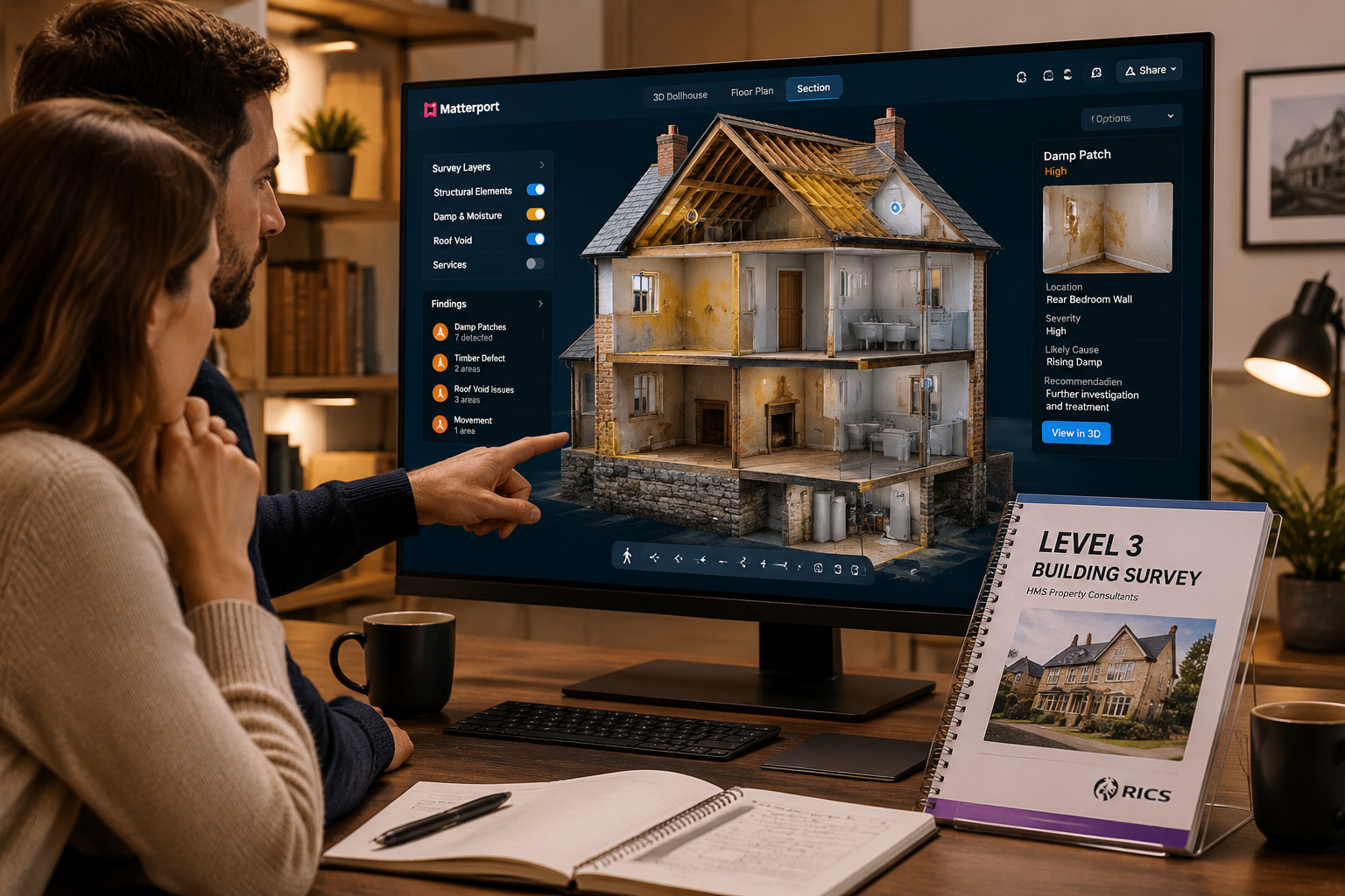
3D Models and Digital Twins
A digital twin is a virtual replica of a physical property, built from laser scan or photogrammetric data. Services like Phaway deliver millimeter-accurate digital twins within days of a site visit, enabling faster decision-making for buyers [3]. Platforms such as Matterport Pro2 and similar systems create immersive 3D tours that allow a buyer to "walk through" a property remotely, take measurements, and share the model with architects, contractors, or mortgage lenders [5].
Pix4D enables the creation of interactive 3D property showcases from drone images, allowing homebuyers to explore properties remotely with high detail [8]. For buyers relocating from another city or country, this capability is transformative — it removes the need for multiple physical visits before a decision is made.
"A digital twin does not just show what a property looks like. It shows exactly how it is built — and where the problems are."
How Smarter Visual Surveys Help Homebuyers Prioritize Repairs and Negotiate
Turning Visual Data Into Financial Decisions
The most practical value of Smarter Visual Surveys: Laser Scanning, Drones, and 3D Models for Homebuyers in 2026 lies not in the technology itself but in what buyers can do with the output.
When a traditional survey report notes "evidence of dampness to the north-facing wall," a buyer faces uncertainty: How widespread is it? Is it penetrating damp or rising damp? What will it cost to fix? Without visual evidence and precise measurements, obtaining accurate repair quotes is difficult.
A laser scan or drone survey changes this conversation entirely. A surveyor can attach annotated point cloud data or drone imagery directly to the relevant section of their report, showing the exact extent of a defect with measurements. A buyer can then take that data to a contractor and receive a meaningful quote — before exchange of contracts.
This is directly relevant to budgeting for repairs and restoration, which is one of the most common challenges buyers face after receiving a survey report. Visual evidence converts vague descriptions into quantifiable repair schedules.
Using Visual Evidence to Negotiate on Price
Surveyors and buyers' agents consistently report that clear photographic and dimensional evidence strengthens a buyer's negotiating position. A written note about "cracking to the chimney stack" is easy for a seller to dismiss. High-resolution drone imagery showing the exact location and scale of the cracking — alongside a contractor's quote for repointing — is much harder to ignore.
For guidance on how to use survey findings effectively in price discussions, the process of negotiating a house price after a survey is well-established, and visual survey data makes that process more evidence-based.
Matching Survey Technology to Property Type
Not every property needs every technology. The table below provides a practical guide.
| Property Type | Recommended Technology | Primary Benefit |
|---|---|---|
| Modern flat or apartment | 3D Matterport tour | Space verification, layout planning |
| Victorian or Edwardian terrace | Drone survey + laser scan | Roof, chimneys, hidden defects |
| Detached or semi-detached house | Drone survey + digital twin | Full external and roof coverage |
| Listed or heritage building | Full laser scan + BIM model | Accurate record of complex geometry |
| Large rural property | Drone photogrammetry | Extensive grounds and outbuildings |
Choosing the Right Survey Level
Advanced visual technology is most effective when paired with the appropriate survey level. For most older or larger properties, a Level 3 full building survey provides the most comprehensive written analysis. Understanding the difference between a Level 2 and Level 3 survey helps buyers decide where to invest their survey budget before adding specialist visual technology.
For buyers still weighing their options, a detailed guide to choosing the right property survey covers the key decision points clearly.
The Practical Landscape for Smarter Visual Surveys in 2026
Accessibility and Cost
One of the most significant shifts in 2026 is that advanced survey technology is no longer limited to large commercial projects. THE FUTURE 3D serves over 300 clients across 18 industries including residential real estate, delivering laser scanning and virtual tours with millimeter-level accuracy [6]. Equipment rental services such as NOAR now offer packages for professional-grade scanners like the Leica BLK360 G2, making the technology accessible to smaller survey firms without heavy capital investment [7].
For buyers wondering about costs, the cost of a measured building survey has become more competitive as the technology has matured, and the value delivered — in terms of defect detection and repair cost clarity — typically far exceeds the fee.
What to Ask a Surveyor Before Booking
Before commissioning a survey, buyers should ask the following questions:
- Does the survey include drone inspection of the roof and external elevations?
- Will a 3D model or point cloud be provided alongside the written report?
- Are defects annotated with measurements and photographs within the report?
- Will the surveyor flag areas where access was limited and recommend specialist follow-up?
- Can the visual data be shared with contractors for quoting purposes?
A surveyor who uses advanced visual tools should be able to answer all of these questions clearly and provide examples of previous reports.
Emerging Developments Worth Watching
Research published on autonomous drone scanning — including work on the FlyCo system — demonstrates that foundation model-empowered drones can conduct autonomous 3D structure scanning in complex open-world environments [9]. This points toward a near future where a drone dispatched to a property can complete a full external survey without manual piloting, reducing cost and survey time further.
Separately, the development of HELIOS++, a simulation framework for topographic 3D laser scanning, is improving how surveyors plan and validate scan coverage before arriving on site [10]. Better planning means fewer gaps in the data and more reliable outputs for buyers.
Conclusion
Smarter Visual Surveys: Laser Scanning, Drones, and 3D Models for Homebuyers in 2026 represent a genuine step forward in how buyers understand the properties they are purchasing. The gap between a written description of a defect and a millimeter-accurate 3D model of that same defect is not merely technological — it is financial. Buyers with clear visual evidence make better repair budgets, negotiate more effectively, and face fewer post-completion surprises.
The core message is straightforward: visual survey technology does not replace a qualified chartered surveyor, but it makes their findings far more actionable. A drone photograph of a failed roof flashing, combined with a surveyor's professional assessment of the risk and a contractor's repair quote, gives a buyer everything needed to make an informed decision.
Actionable next steps for homebuyers in 2026:
- When booking a survey, ask specifically whether drone inspection and 3D scanning are included or available as add-ons.
- Review the surveyor's sample reports to confirm that defects are supported by annotated photographs and measurements — not just written descriptions.
- Use the visual data from the survey to obtain repair quotes before exchange of contracts, not after.
- For properties with complex roofs, chimneys, or heritage features, treat a drone survey as essential rather than optional.
- Combine the visual survey output with the appropriate Level 2 or Level 3 written report to build the strongest possible evidence base for your purchase decision.
The technology exists. The question for every homebuyer in 2026 is simply whether they choose to use it.
References
[1] aestra3d – https://www.aestra3d.com/?utm_source=openai
[2] gtec3d – https://www.gtec3d.com/?utm_source=openai
[3] phaway.ai – https://www.phaway.ai/?utm_source=openai
[4] Overview – https://shop.leica-geosystems.com/global/leica-blk/blk2fly/overview?utm_source=openai
[5] dreamoverture – https://dreamoverture.com/?utm_source=openai
[6] thefuture3d – https://www.thefuture3d.com/?utm_source=openai
[7] Rentals – https://www.noartechnologies.com/rentals?utm_source=openai
[8] Real Estate – https://www.pix4d.com/industry/real-estate?utm_source=openai
[9] arxiv – https://arxiv.org/abs/2601.07558?utm_source=openai
[10] arxiv – https://arxiv.org/abs/2101.09154?utm_source=openai