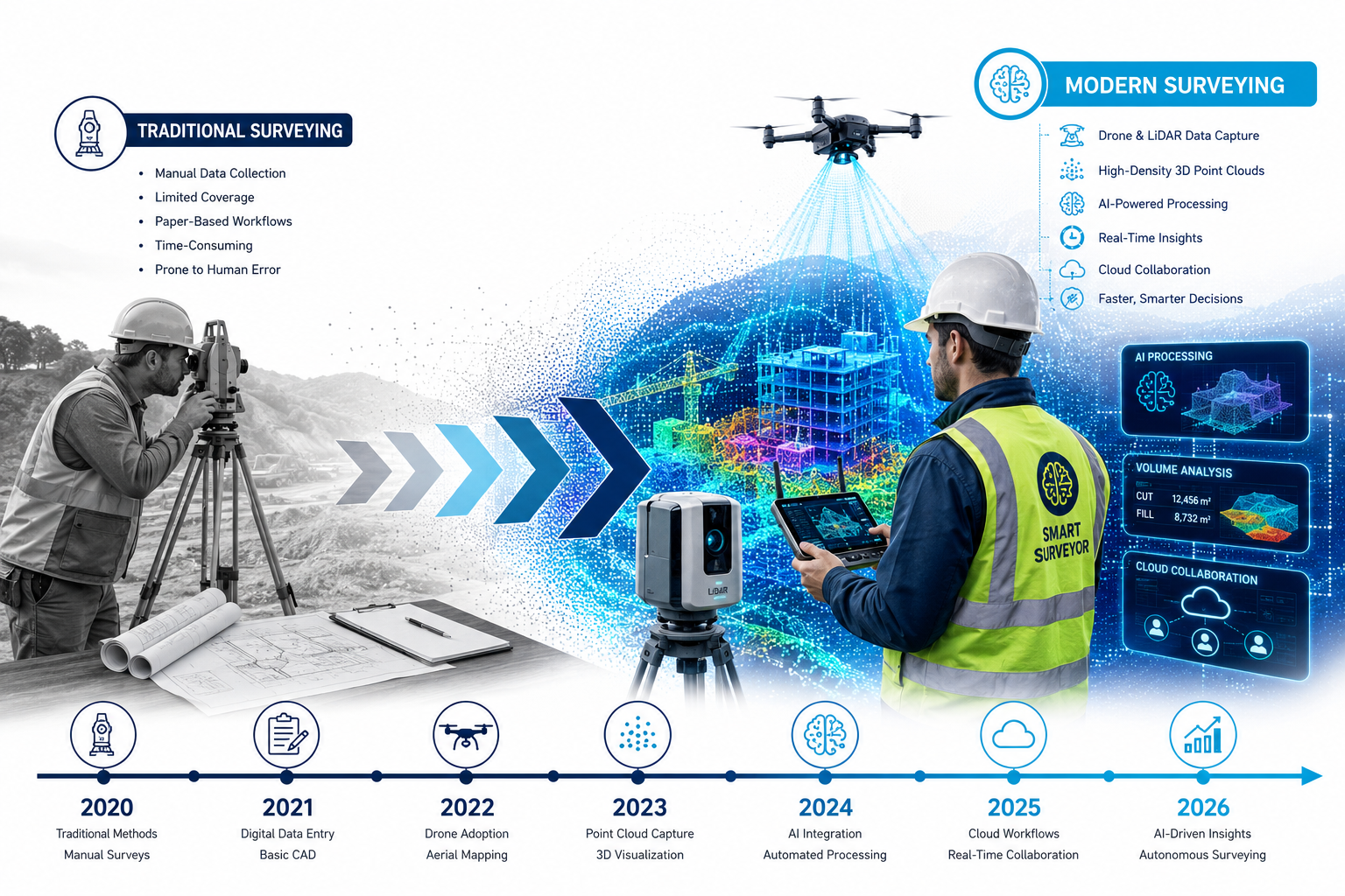
By 2026, the global reality capture market is projected to exceed $12 billion — and for the first time, the technology powering it is no longer reserved for large engineering firms with deep pockets. The shift is seismic: Reality Capture Goes Mainstream: Digital Tools Every Surveyor Needs in 2026 is no longer a futuristic headline — it is the daily reality for surveyors across the UK and beyond. [10]
Whether you work in residential valuation, commercial building surveys, or large-scale topographic mapping, digital capture tools are reshaping how quickly and accurately work gets done. The question is no longer whether to adopt these tools — it is which ones to prioritise and how to integrate them into your practice without disrupting the work you already do well.
Key Takeaways 📌
- Reality capture is now accessible to independent surveyors and small firms, not just large corporations.
- AI-assisted LiDAR and photogrammetry tools can cut project delivery times by up to 100x compared to manual workflows.
- Cloud-native platforms allow surveyors to store, analyse, and share massive datasets without expensive on-premise infrastructure.
- Workforce shortages are accelerating adoption — digital tools allow smaller teams to deliver more without sacrificing accuracy.
- Affordable software options (some under £2,000) now offer full CAD and 3D modelling functionality for survey-grade deliverables.
What Does "Reality Capture" Actually Mean in 2026?
Reality capture refers to the process of digitally recording the physical world — buildings, landscapes, infrastructure — using technologies like LiDAR scanning, photogrammetry, drone mapping, and structured light scanning. The output is typically a point cloud: a dense, three-dimensional set of data points that can be processed into accurate models, drawings, or digital twins.
Until recently, this workflow demanded expensive hardware, specialist software licences, and teams of trained technicians. That barrier has largely collapsed. [10]
💬 "The surveying profession is experiencing a digital transformation, with reality capture evolving from a specialised service to an accessible toolset for firms of all sizes." — The American Surveyor, 2026
The implications are significant for professionals delivering building surveys and maintenance assessments or conducting building pathology investigations, where precise spatial data can reveal defects that traditional inspection methods might miss.
The Workforce Problem Driving Digital Adoption
The UK surveying sector faces a well-documented skills shortage. The RICS has flagged declining graduate pipelines for years, and experienced surveyors are retiring faster than new talent enters the profession. The result: firms are being asked to deliver more with fewer people.
This is precisely why Reality Capture Goes Mainstream: Digital Tools Every Surveyor Needs in 2026 matters so urgently. When a single surveyor with a LiDAR-equipped drone can capture data for a site that would previously have required a three-person team over two days, the economics change entirely.
Key workforce pressures in 2026:
| Challenge | Impact | Digital Solution |
|---|---|---|
| Fewer qualified surveyors | Longer project timelines | AI-assisted data processing |
| Rising client expectations | Demand for faster turnaround | Drone + cloud workflows |
| Complex heritage buildings | Manual access difficulties | Remote LiDAR capture |
| Cost pressure on small firms | Reduced margins | Affordable SaaS platforms |
Understanding how building surveyors gain access to difficult properties is itself evolving — drones and remote scanners are increasingly filling gaps where physical access is restricted or unsafe.
The Essential Digital Toolkit: Reality Capture Goes Mainstream for Every Budget
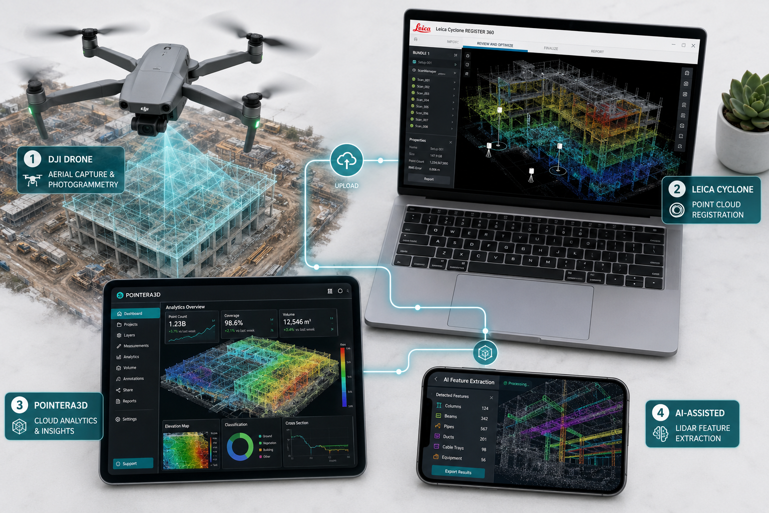
🛸 1. AI-Powered Drone Mapping Platforms
Drone mapping has matured rapidly. Platforms like DJI Terra and Pix4D now use AI to automate photogrammetry workflows — generating 3D point clouds, orthomosaics, and digital elevation models from aerial imagery with minimal manual input. [3]
For surveyors covering wide geographic areas — from chartered surveyors in Essex to chartered surveyors in Berkshire — drone mapping dramatically reduces site visit time while improving the completeness of data captured.
Why it matters:
- Covers large sites in a fraction of the time
- Generates deliverables clients can visualise immediately
- Integrates with most CAD and GIS platforms
- Increasingly affordable — entry-level survey drones start below £2,000
For a deeper look at how drone technology is being applied to property surveys in the UK, explore Prince Chartered Surveyors' premium drone survey services.
🔬 2. LiDAR Feature Extraction with AI: Mach9 Digital Surveyor 2
Released in March 2026, Mach9's Digital Surveyor 2 represents a significant leap in LiDAR processing capability. The platform uses AI-assisted workflows that enable survey and geospatial teams to deliver projects up to 100 times faster than traditional manual extraction methods — without any reduction in accuracy. [1]
This is not incremental improvement. A workflow that once took a week can now be completed in hours. For firms managing multiple concurrent projects, this kind of throughput change is transformational.
Digital Surveyor 2 key capabilities:
- ✅ Automated feature extraction from raw LiDAR data
- ✅ AI-driven classification of roads, vegetation, structures, and utilities
- ✅ Seamless export to standard CAD and GIS formats
- ✅ Scalable for both small residential and large infrastructure projects
☁️ 3. Cloud-Native Reality Data Management: Pointerra3D
Introduced at Geo Week 2026, the Pointerra3D Digital Surveyor Bundle addresses one of the most persistent pain points in modern surveying: managing enormous datasets without expensive on-premise infrastructure. [6]
This cloud-native solution allows surveyors to store, visualise, annotate, and analyse large-scale reality datasets directly in the cloud — with advanced analytics available on a project-by-project basis and no fixed software licence required.
Why cloud-native matters for small firms:
💬 "The democratisation of reality capture tools allows independent surveyors and small firms to deliver high-precision 3D surveys, previously reserved for large-scale projects, to residential and small commercial clients."
The pay-per-project model removes the barrier of large upfront software costs — a significant advantage for firms that need flexibility as their workload fluctuates.
📐 4. Integrated Surveying Environments: Analist 2026
Analist 2026 provides a comprehensive software environment that brings together data from GPS receivers, total stations, drones, and laser scanners in a single interface. [2] It supports:
- Point cloud management and visualisation
- 3D modelling and BIM-compatible outputs
- Architectural and topographic survey workflows
- Streamlined data import from virtually any hardware source
For surveyors who work across multiple data collection methods — a common reality for professionals delivering measured surveys — having a single integrated environment eliminates the time-consuming process of converting between formats.
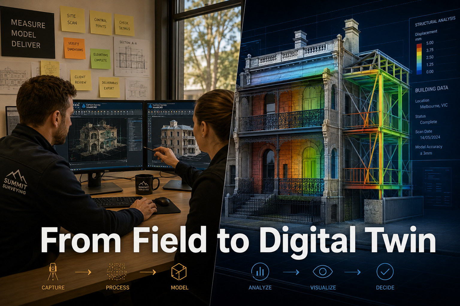
🖥️ 5. Affordable CAD for Land Surveyors: Carlson Survey IntelliCAD 2026
Not every firm needs enterprise-grade software. Carlson Survey IntelliCAD 2026, priced at $2,349.95, delivers full CAD functionality tailored specifically for land surveyors — including advanced coordinate geometry, lot layout, and surface modelling. [4]
It is a strong option for independent practitioners who need survey-grade deliverables without committing to expensive subscription platforms. The software emphasises precision and flexibility, and its IntelliCAD foundation means it is compatible with the DWG file format used across the industry.
🔗 6. Point Cloud Registration: Leica Cyclone REGISTER 360 PLUS
Leica Cyclone REGISTER 360 PLUS 2026.0.1 remains the industry standard for registering and processing scan data from terrestrial laser scanners. The latest release focuses on interoperability and user productivity, adding FAFx file format import and improved GeoTag handling to facilitate smoother field-to-office workflows. [5]
For surveyors working on complex heritage buildings or properties with significant environmental issues, the ability to register multiple scans accurately — and share them efficiently with design teams — is critical.
🔧 7. BricsCAD Integration: MicroSurvey SurveyTools
MicroSurvey's SurveyTools for BricsCAD combines BricsCAD's powerful surfacing and point cloud tools with a dedicated suite of survey-specific functions. [9] The result is an all-in-one solution that accelerates productivity while maintaining data integrity — particularly useful for firms transitioning from AutoCAD-based workflows.
Adoption Strategies: Making the Transition Work
Knowing which tools exist is only half the challenge. Successfully integrating them into an active practice requires a structured approach.
Start With One Workflow, Not Everything at Once
The most common mistake firms make is attempting to overhaul all processes simultaneously. Instead, identify the single workflow that causes the most delay or client friction — whether that is site data capture, plan production, or report delivery — and pilot one tool there first.
Invest in Training Before Hardware
New hardware without trained operators delivers poor results. Budget for structured training — many platform providers now offer online certification programmes that can be completed without leaving the office.
Communicate the Value to Clients
Clients increasingly expect faster turnaround and richer deliverables. A 3D model or an interactive point cloud viewer is a tangible demonstration of value that justifies premium fees. For surveyors involved in commercial valuations or insurance reinstatement cost valuations, precise spatial data can directly improve the accuracy — and defensibility — of figures provided.
Consider Cloud-First for Data Storage
On-premise servers are expensive to maintain and create bottlenecks when teams need to collaborate remotely. Cloud-native platforms like Pointerra3D remove these constraints and scale with your workload. [6]
Build a Technology Roadmap
Reality capture technology is evolving quickly. Firms that adopt tools reactively — chasing the latest release without a coherent strategy — often end up with incompatible systems and duplicated costs. A simple 12-month technology roadmap, reviewed quarterly, keeps adoption purposeful and cost-effective.
Reality Capture Goes Mainstream: What This Means for UK Surveyors Specifically
The UK property market presents specific challenges and opportunities for reality capture adoption. Dense urban environments, a high proportion of heritage stock, and complex planning regulations all create demand for precise, detailed spatial data.
Trimble's reality capture solutions are explicitly designed to support applications from topographic surveys to full digital twins — a workflow increasingly relevant for surveyors working across mixed-use urban developments. [7] The ability to capture, process, and deliver a digital twin of a building is becoming a competitive differentiator, particularly in London and the South East.
For firms operating across locations such as Central London, South West London, or Hertfordshire, the ability to deliver faster, more accurate surveys without increasing headcount is a direct competitive advantage in a market where client expectations are rising and qualified staff are hard to find.
Conclusion: Act Now, Stay Ahead
The convergence of affordable hardware, AI-powered processing, and cloud-native delivery has removed the last major barriers to reality capture adoption. Reality Capture Goes Mainstream: Digital Tools Every Surveyor Needs in 2026 is not a trend to monitor from the sidelines — it is a capability shift that is already redefining what clients expect and what competitors can deliver.
Actionable Next Steps ✅
- Audit your current workflows — identify where manual processes are creating bottlenecks or errors.
- Pilot one tool — start with drone mapping or a cloud point cloud platform on a low-risk project.
- Engage your team — involve surveyors in tool selection to drive buy-in and faster adoption.
- Talk to your clients — ask what deliverable formats would add the most value for them.
- Build a roadmap — plan technology investment over 12–24 months, not as one-off purchases.
- Explore specialist services — consider partnering with firms already offering premium drone survey capabilities while you build internal capacity.
The firms that move decisively now will be the ones setting the standard in 2027 and beyond.
References
[1] Mach9 Unveils Digital Surveyor 2 A New Standard For Lidar Feature Extraction – https://lidarmag.com/2026/03/19/mach9-unveils-digital-surveyor-2-a-new-standard-for-lidar-feature-extraction/?utm_source=openai
[2] Topographic Survey Software – https://www.analistgroup.com//en/land-survey-solutions/topographic-survey-software?utm_source=openai
[3] 521 Best Ai Tools For Surveyors 2026 – https://trybuildpilot.com/521-best-ai-tools-for-surveyors-2026?utm_source=openai
[4] Carlson Survey Intellicad – https://carlsonps.com/products/carlson-survey-intellicad?utm_source=openai
[5] Leica Cyclone Register 360 – https://yousoftly.ir/software/leica-cyclone-register-360/?utm_source=openai
[6] Geo Week Spotlight Pointerra3d Launches The Digital Surveyor Bundle With Exclusive Offer – https://www.geoweeknews.com/sponsored/geo-week-spotlight-pointerra3d-launches-the-digital-surveyor-bundle-with-exclusive-offer?utm_source=openai
[7] Reality Capture – https://geospatial.trimble.com/en/industries/surveying-and-mapping/reality-capture?utm_source=openai
[9] Surveytools – https://www.microsurvey.com/products/surveytools/?utm_source=openai
[10] Doubling Down On Digital – https://amerisurv.com/2026/02/01/doubling-down-on-digital/?utm_source=openai