

Only 12% of homebuyers fully understand the defect descriptions in a standard written survey report — yet those same reports routinely influence six-figure purchasing decisions. That gap between technical language and buyer comprehension is precisely where 3D modelling and digital twins in RICS home surveys are changing the game. For 2026 buyers navigating a complex property market, the shift from static PDF reports to interactive, data-rich 3D environments is not a luxury — it is rapidly becoming an expectation.
This article examines how laser scanning, point cloud capture, and digital twin technology are being integrated into residential RICS surveys to deliver clearer defect highlighting, sharper risk prioritisation, and more defensible valuation adjustments — all in a format that buyers can actually understand.
Key Takeaways 🏠
- Digital twins transform a survey from a static document into a living, navigable model of a property's condition.
- 3D laser scanning captures millimetre-accurate spatial data, enabling surveyors to tag defects directly in a virtual environment.
- Buyers can remotely "walk through" a property and examine hard-to-access areas such as roof voids and subfloor spaces.
- Defect visualisation in 3D directly supports price negotiation and remedial cost budgeting.
- RICS and industry bodies are actively positioning digital twinning as a core competency for surveyors in 2026 and beyond. [1]
From Flat Reports to Living Models: The Technology Behind the Shift
For decades, a RICS home survey meant a PDF document — pages of condition ratings, written descriptions, and a handful of photographs. For a Level 3 Full Building Survey, that report might run to 60 pages. The information was thorough, but the format was passive. Buyers had to mentally translate written descriptions of damp, cracking, or roof deterioration into a spatial understanding of the property — a significant cognitive leap for anyone who is not a construction professional.
How Laser Scanning and Point Clouds Work
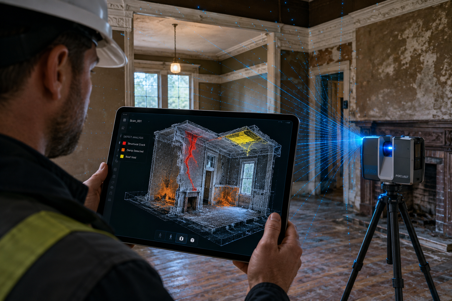
The foundation of modern 3D survey technology is LiDAR (Light Detection and Ranging) scanning. A tripod-mounted scanner emits millions of laser pulses per second, measuring the precise distance to every surface it strikes. The result is a point cloud — a dense, three-dimensional constellation of data points that accurately maps every wall, ceiling, floor, and structural element within its field of view. Multiple scan positions are stitched together to create a complete, navigable model of the entire building. [2]
From this point cloud, surveyors and specialist software can generate:
- 📐 Accurate floor plans (to within ±2mm in many cases)
- 🏗️ 3D rendered walkthroughs viewable on any device
- 📍 Tagged defect annotations pinned to exact locations in the model
- 📊 Dimensional data for calculating areas, volumes, and structural deviations
Defining the Digital Twin in a Residential Context
The term "digital twin" is sometimes used loosely, but in a surveying context it carries a specific meaning. RICS research defines digital twins as "digital replicas of built assets that integrate data from multiple sources across the asset lifecycle" — not just a 3D model, but a dynamic, updateable record that can absorb new data over time. [10]
Terra Measurement describes the concept as a "digital representation of a real-world entity or system" implemented as a software model that mirrors the physical asset. Crucially, multiple twins can be aggregated to understand performance at building, portfolio, or even neighbourhood scale. [2]
For a 2026 homebuyer, this means their survey is not just a snapshot of condition on a single day. It is the foundation of a living record — one that can be updated after remedial works, referenced during future sales, or used to plan maintenance schedules. This lifecycle value is a fundamental difference from any traditional report format.
"The digital twin doesn't just show you what's wrong — it shows you where it is, how bad it is, and what happens if you ignore it." — Emerging consensus among residential surveying practitioners [4]
How 3D Modelling and Digital Twins in RICS Home Surveys Enhance Defect Visualisation
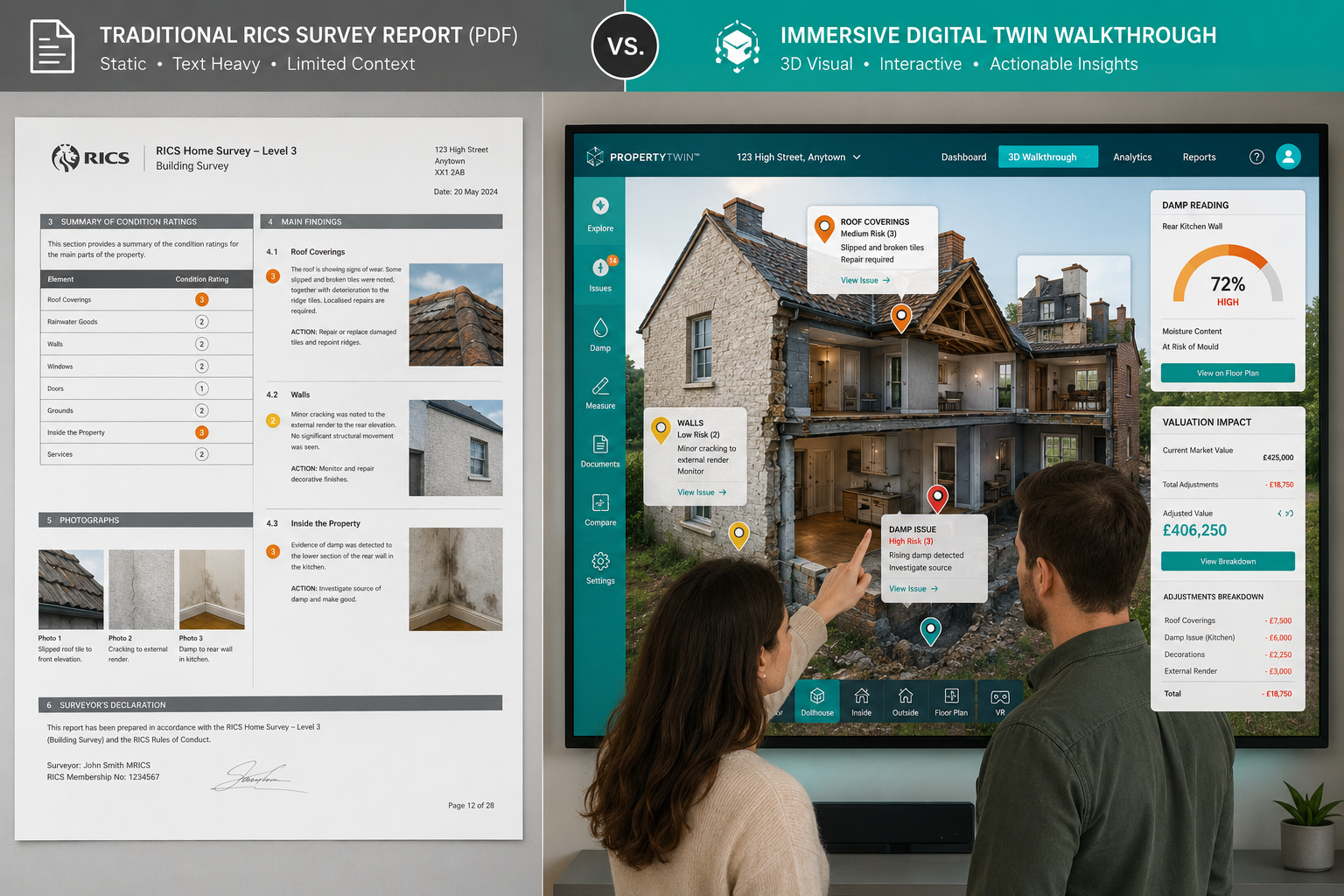
The core promise of 3D modelling and digital twins in RICS home surveys is simple: buyers should be able to see what their surveyor sees. Traditional reports rely on written condition ratings (typically a traffic-light system) and photographs. Both have limitations.
A photograph of a damp patch on a wall tells you the patch exists. It does not tell you how large the affected area is, whether it extends behind a fitted wardrobe, or how close it is to a load-bearing element. A 3D model with tagged annotations does all three — and it does so in a format that requires no technical training to interpret.
Defect Tagging and Risk Prioritisation
Specialist surveyors are already using real-time 3D digital twins to "tag" defect locations directly in the 3D environment. [4] This approach delivers several measurable benefits:
| Traditional Report | 3D Digital Twin Survey |
|---|---|
| Written description of defect location | Pin-point tag in navigable 3D model |
| Photograph (single angle) | 360° contextual view of defect zone |
| Condition rating (1–3 or traffic light) | Severity annotation with spatial extent |
| Separate remedial cost estimate | Integrated valuation adjustment note |
| Static PDF | Shareable, interactive digital file |
For common defects in older homes — rising damp, roof spread, lintel failure, or subsidence cracking — the ability to see the defect in its full spatial context is transformative. A buyer can zoom into the model, rotate the view, and understand whether a crack is in a party wall, a chimney breast, or a structural pier. That context changes everything about how risk is perceived and priced.
Remote Viewing and Hard-to-Access Areas
One of the most practically significant benefits is the ability for buyers to remotely examine areas that are difficult or impossible to access during a standard viewing. Roof voids, subfloor spaces, and areas behind fitted units are routinely flagged in surveys as "not inspected due to restricted access." [3]
With 3D scanning, a surveyor equipped with appropriate access equipment can capture these spaces during the survey itself, embedding them into the walkthrough model. A buyer sitting at home can then navigate into the roof space, examine the timber structure, and see any tagged concerns — without ever setting foot on a ladder. This is particularly relevant for building surveys of older or complex properties where hidden defects carry the greatest financial risk.
Supporting the "Story of the Building"
RICS' Property Journal describes digital twinning as a tool that helps surveyors communicate the "story of the building" — the sequence of alterations, repairs, and deterioration that explains the current condition. [1] High-resolution 3D models and walkthroughs reduce ambiguity in defect descriptions and help non-technical buyers visualise condition issues and layout impacts in a way that written reports simply cannot replicate.
This narrative quality is especially valuable when a property has undergone multiple extensions or alterations. For buyers considering home extension cost considerations or structural modifications, understanding the existing building fabric in three dimensions is an essential starting point.
Valuation Accuracy and the Financial Case for 3D Survey Technology
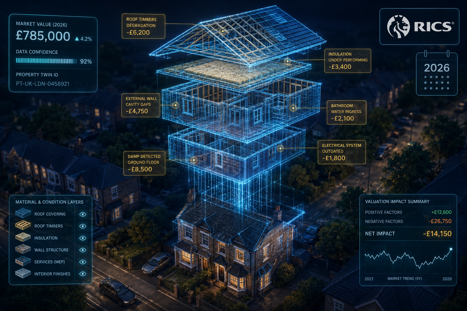
The connection between better defect visualisation and more accurate valuation is direct. When buyers can clearly see and understand the extent of defects, they are better equipped to make informed offers — and surveyors are better positioned to justify valuation adjustments with spatial evidence rather than written opinion alone.
How Digital Twins Inform Valuation Adjustments
Surveyors using 3D modelling report that tagged defect models allow them to:
- Quantify affected areas precisely (e.g., square metreage of damp penetration)
- Demonstrate proximity of defects to structural or high-value elements
- Provide defensible evidence for recommended price reductions or retention sums
- Support cost-to-cure estimates by sharing the model with contractors for remote quoting [9]
For buyers seeking budgeting for repairs and restoration, a 3D model with annotated defects provides a far more reliable basis for contractor quotations than a written description and a single photograph. Contractors can navigate the model, measure affected areas, and price works with greater confidence — reducing the risk of surprise costs post-completion.
Valuation in Specialist Contexts
The benefits extend beyond standard residential transactions. In specialist valuation scenarios — such as capital gains valuations or insurance reinstatement cost valuations — a digital twin provides an accurate, timestamped record of the property's condition at a specific point in time. This is invaluable for dispute resolution, insurance claims, or tax assessments where the condition and configuration of the property must be evidenced precisely.
Similarly, for leasehold extension and enfranchisement valuations, the ability to accurately measure floor areas and document the condition of communal elements can materially affect the premium calculation.
The Negotiation Advantage 💰
Nottingham-based surveyors note that 3D tagged defect models allow buyers to enter price negotiations with visual, spatial evidence rather than relying on written survey extracts. [4] Presenting a seller with a navigable model that shows the extent of a damp zone or the spread of roof timbers is considerably more persuasive than quoting a paragraph from a PDF. This shifts the negotiation dynamic — buyers are better informed, sellers are less able to dismiss concerns as exaggerated, and agreed price reductions are more likely to reflect actual remediation costs.
Practical Considerations for 2026 Buyers
What to Ask Your Surveyor 🔍
Not all RICS surveyors currently offer 3D modelling or digital twin deliverables as standard. When commissioning a survey, buyers should consider asking:
- Does the survey include 3D scanning or point cloud capture?
- Will defects be tagged in a navigable 3D model or walkthrough?
- Can the model be shared with contractors for remote quoting?
- Is the digital twin updateable after remedial works are completed?
- How are hard-to-access areas (roof voids, subfloors) captured?
For a comprehensive checklist of survey questions, the guide on what questions you should be asking during a building survey is an excellent starting point.
Technology Accessibility in 2026
The democratisation of 3D capture technology is accelerating. Tools such as Matterport, Leica BLK series scanners, and increasingly capable smartphone-based LiDAR applications are making high-quality 3D survey capture accessible to a wider range of practices. [7] [9] The cost of 3D scanning has fallen significantly — reality capture technology that cost tens of thousands of pounds a decade ago is now available at a fraction of that price, enabling smaller surveying firms to offer these services competitively. [9]
This means 2026 buyers should not assume that 3D survey technology is only available from large corporate practices. Independent chartered surveyors are increasingly equipped to deliver these outputs, particularly for Level 3 Full Building Surveys of complex or high-value properties.
Limitations to Be Aware Of ⚠️
Digital twins and 3D models are powerful tools, but they have limitations:
- Scanning captures surfaces, not hidden fabric. Concealed defects behind plasterwork or within wall cavities still require invasive investigation or specialist thermal imaging.
- Model quality depends on scan coverage. Areas not scanned cannot be modelled — access restrictions still apply.
- Interpretation still requires expertise. A 3D model without a qualified surveyor's analysis is just geometry. The professional judgement of a RICS-qualified surveyor remains essential.
- Data management and security. Digital twin files contain detailed spatial data about private homes — buyers and surveyors should understand how this data is stored and shared.
The Broader Industry Direction: RICS and the 2026 Digital Landscape
RICS has been clear in its positioning: digital twinning is not a niche add-on but a core competency for the modern surveyor. [1] Six key surveying trends identified for 2026 include accelerating digital transformation, with 3D capture and digital twin integration cited as among the most significant shifts reshaping residential survey practice. [3]
The Trimble 2026 Market Survey, which canvasses professionals across the built environment, highlights that the tools and technologies defining the industry are shifting rapidly toward integrated digital workflows — with 3D data capture at the centre. [6]
For buyers, this trajectory has a straightforward implication: the information available to support a property purchase decision is becoming richer, more visual, and more actionable. The gap between what a surveyor knows and what a buyer understands is closing — and that is unambiguously good for the market.
Conclusion: Actionable Next Steps for 2026 Buyers
The evolution from static written reports to interactive 3D digital twins represents the most significant shift in residential survey practice in a generation. For 2026 buyers, the practical implications are clear and actionable.
Here is what to do next:
- ✅ Commission a Level 3 Building Survey for any property that is older, extended, or shows visible signs of defects — and specifically request 3D modelling capability where available.
- ✅ Ask about defect tagging in the 3D model so you can share the survey output directly with contractors for accurate remediation quotes.
- ✅ Use the digital twin for negotiation — a spatial, annotated model is far more persuasive evidence for a price reduction than a written paragraph.
- ✅ Consider the lifecycle value — a digital twin is not just a purchase tool. It is the foundation of a maintenance and improvement record for the life of your ownership.
- ✅ Engage a RICS-qualified surveyor who can explain how digital tools integrate with their professional judgement — technology enhances expertise, it does not replace it.
The properties being bought in 2026 deserve survey reports that match the sophistication of the decisions being made. 3D modelling and digital twins in RICS home surveys are delivering exactly that — and buyers who understand this technology will be better informed, better protected, and better positioned at the negotiating table.
References
[1] What Digital Twinning Offers Surveying – ww3.rics.org
[2] Measured Building – terrameasurement.com
[3] Six Key Surveying Trends For 2026 Accelerating Digital Transformation – canterburysurveyors.com
[4] Real Time 3d Digital Twins Transforming Property Visualization And Decision Making – nottinghillsurveyors.com
[5] Digital Twins And Thermal Imaging In Building Surveys Enhancing Predictive Accuracy For 2026 Compliance Checks – Digital twins and thermal imaging in building surveys enhancing predictive accuracy for 2026 compliance checks
[6] Trimble 2026 Market Survey – facebook.com
[7] Matterport Digital Twin – cadsonline.com
[8] Digital Twin Truth Why Real Estate Needs Survey Grade – linkedin.com
[9] Reality Capture Democratization Affordable 3d Tools Empowering Small Scale Property Surveys In 2026 – manchestersurveyors.com
[10] Digital Twins From Design To Handover Of Constructed Assets – rics.org