

The global land survey equipment market is valued at USD 8.7 billion in 2026 — and it is on course to hit USD 13.2 billion by 2036, growing at a steady 4.2% CAGR [1]. That is not a bubble. That is a structural shift driven by infrastructure megaprojects, digital twin mandates, and the relentless push for millimetre-level accuracy on construction sites from Mumbai to Manchester.
For surveyors, contractors, and property professionals deciding where to spend their equipment budgets, the 2026 Land Survey Equipment Boom: Comparing Total Stations, GPS RTK, and Laser Scanners has never been more relevant. Three instrument categories dominate the field — and choosing the wrong one for a project does not just cost time. It costs money, accuracy, and client trust.
This guide breaks down each technology, compares real-world performance, and delivers a practical buying framework for 2026.

Key Takeaways 📌
- Total stations hold the largest equipment market share (38.4%) in 2026 and remain essential for high-precision layout, control networks, and obstructed environments [1].
- GPS RTK systems are the fastest-growing category for open-sky topography, corridor surveys, and construction stakeout, now supporting multi-constellation GNSS for better reliability [3].
- Laser scanners are the smallest but fastest-expanding segment, driven by BIM integration, digital twin projects, and as-built documentation [4].
- Leading brands in 2026 — Trimble, Topcon, Hexagon (Leica Geosystems), and Hemisphere GNSS — all market integrated workflows using all three instrument types [3].
- Smart firms in 2026 do not choose one tool. They deploy all three, selecting instruments based on line-of-sight, accuracy requirements, and deliverable type [6].
The Market Behind the 2026 Land Survey Equipment Boom
Why Demand Is Surging Right Now
Three forces are fuelling the 2026 land survey equipment boom simultaneously:
- Infrastructure investment — Governments in the USA, India, China, Germany, and Brazil are committing record capital to transport, energy, and utilities. Brazil alone is projected at a 3.7% CAGR through 2036 [1].
- Digital twin and BIM mandates — Clients increasingly require 3D as-built data, driving adoption of laser scanners and integrated survey workflows [4].
- Labour efficiency pressure — Robotic total stations and cloud-connected RTK rovers let smaller teams cover more ground without sacrificing accuracy [6].
💡 Pull Quote: "The boom is not about one instrument replacing another. It is about infrastructure complexity demanding all three technologies working together." — Industry consensus, 2026 [6]
Who Is Buying and Where
| Region | Growth Driver | Key Equipment Demand |
|---|---|---|
| USA | Highway & rail expansion | Total stations, RTK, scanners |
| India | Smart city & infrastructure | GNSS/RTK, total stations |
| China | Urban development, BIM | Laser scanners, total stations |
| Germany | Precision engineering | Robotic total stations |
| Brazil | Energy & transport corridors | RTK, total stations [1] |
For UK-based surveyors, the same dynamics apply. Major infrastructure programmes and the growing use of drone surveys and advanced spatial data capture are pushing firms to re-evaluate their entire equipment stack.
Total Stations: Still the Backbone of Precision Surveying
What They Do and Why They Still Lead
Total stations combine electronic distance measurement (EDM), angle measurement, and automatic target recognition in a single instrument. Modern robotic versions add remote operation, reflectorless measurement, and imaging sensors — a far cry from their early predecessors [10].
In 2026, total stations hold 38.4% of the global land survey equipment market by value [1]. That dominance is not nostalgia. It reflects genuine, irreplaceable capability:
- ✅ Sub-millimetre accuracy for control networks and building layout
- ✅ Reliable performance in GNSS-denied environments (tunnels, dense urban canyons, under bridges)
- ✅ Essential for structural monitoring and deformation surveys
- ✅ Precise stakeout where tolerances are tight (±2–5mm)
Practitioner feedback from 2026 confirms that conventional and robotic total stations remain the go-to for tight control, building layout, and any condition where GNSS is obstructed or unreliable [8].
Pros and Cons at a Glance
| ✅ Pros | ❌ Cons |
|---|---|
| Highest positional accuracy | Requires line of sight to target |
| Works in GNSS-denied zones | Slower than RTK for large areas |
| Ideal for structural monitoring | Higher operator skill required |
| Excellent for building layout | Two-person setup (non-robotic) |
| Long-established workflows | Higher unit cost for robotic models |
Typical Cost Range (2026)
- Conventional total station: £3,000–£8,000
- Robotic total station (mid-tier): £15,000–£35,000
- High-end robotic with imaging: £40,000–£70,000+
ROI Snapshot 💰
A robotic total station eliminates the need for a second crew member on most layout tasks. At an average UK surveying day rate of £400–£600 per person, a £25,000 robotic instrument pays for itself in 42–63 working days of solo operation — typically within one to two major projects.
GPS RTK: Speed and Scale for Open-Sky Environments
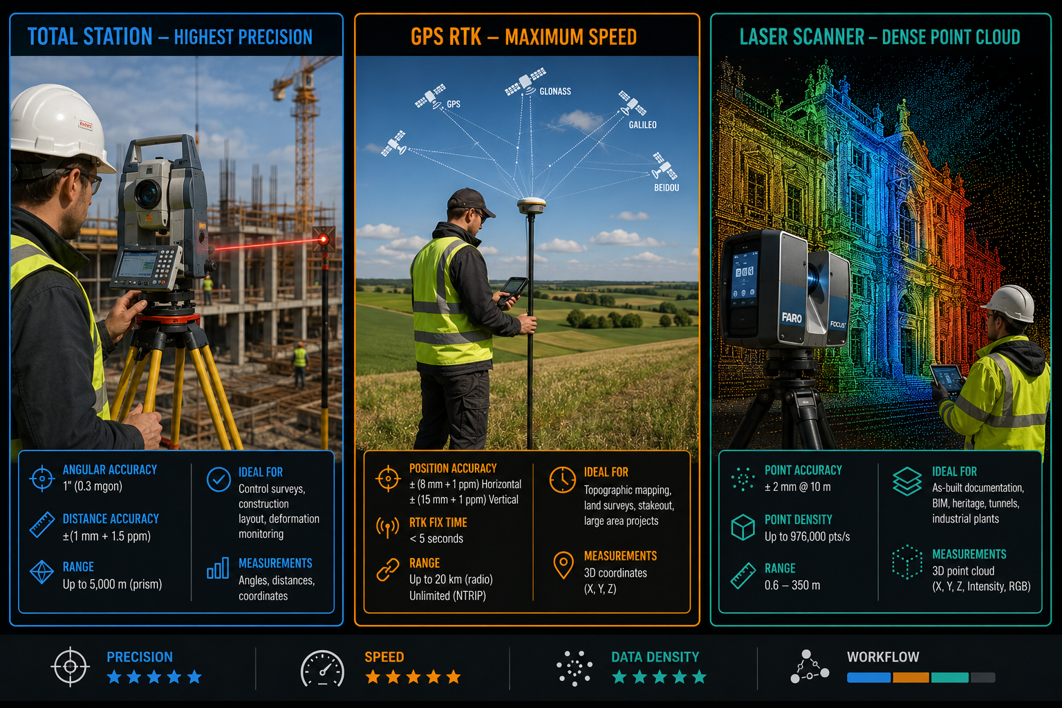
The Case for RTK in 2026
GPS RTK (Real-Time Kinematic) systems have become the default tool for fast topographic work, boundary surveys, and construction stakeout across large, open areas [3]. In 2026, the technology has matured significantly:
- Multi-constellation GNSS support — Modern RTK rovers track GPS, GLONASS, Galileo, and BeiDou simultaneously, dramatically improving fix reliability in challenging conditions [5].
- Cloud connectivity — Data syncs directly to office software, reducing post-processing time and enabling real-time project management [5].
- Network RTK (NRTK) — Correction services via mobile networks deliver centimetre-level accuracy without a base station, cutting setup time on corridor projects.
Top-tier brands in 2026 — Trimble, Topcon, Hexagon (Leica Geosystems), and Hemisphere GNSS — all offer RTK systems with these capabilities. GeoMax (a Leica sub-brand) is flagged as a strong value alternative for budget-conscious firms [3].
Pros and Cons at a Glance
| ✅ Pros | ❌ Cons |
|---|---|
| Very fast data capture | Requires clear sky view |
| One-person operation | Multipath errors near buildings |
| Large-area coverage | Less reliable under tree canopy |
| Cloud data integration | Dependent on correction network |
| Centimetre-level accuracy | Not suitable for tunnels/indoors |
Typical Cost Range (2026)
- Entry-level RTK system: £5,000–£12,000
- Mid-tier multi-constellation rover + base: £15,000–£28,000
- High-end professional system: £30,000–£55,000
RTK vs. Total Station: When to Choose Which
The professional consensus in 2026 is clear: RTK has not killed total stations. Instead, it has shifted them toward specialised, high-precision, and line-of-sight-dependent roles [8].
Use RTK when:
- Surveying open farmland, road corridors, or coastal areas
- Speed of data capture is the priority
- Working with large teams on construction sites with clear sky access
Use a total station when:
- Setting out building foundations to ±3mm tolerance
- Working in urban canyons, tunnels, or under structures
- Running a precise control network
For property professionals undertaking building surveys and condition reports, understanding which instrument underpins the spatial data in a report matters — it directly affects the accuracy of measurements and boundary determinations.
Laser Scanners: The Digital Twin Powerhouse
Why Scanners Are the Fastest-Growing Segment
Terrestrial and mobile laser scanners capture millions of points per second, producing dense 3D point clouds that serve as the foundation for digital twins, BIM models, and as-built documentation [4]. While they represent a smaller market share than total stations or RTK systems, they are the fastest-growing category in the 2026 land survey equipment boom [1].
Key drivers in 2026:
- 🏗️ BIM Level 2+ mandates on UK public sector projects
- 🌉 Infrastructure as-built documentation for highways, rail, and bridges
- 🏛️ Heritage recording of listed buildings and conservation areas
- 🔍 Deformation monitoring on critical structures
Manufacturers like Topcon specifically market scanning solutions for bridge, road, rail, and tunnel projects — positioning scanners as part of an integrated three-instrument workflow rather than a standalone purchase [9].
Pros and Cons at a Glance
| ✅ Pros | ❌ Cons |
|---|---|
| Extremely dense data capture | High equipment cost |
| Full 3D documentation | Large data files, processing time |
| Ideal for BIM/digital twins | Specialist software required |
| Minimal site disruption | Less suited for stakeout/layout |
| Excellent for heritage recording | Steep learning curve |
Typical Cost Range (2026)
- Entry-level terrestrial scanner: £20,000–£45,000
- Mid-tier scanner (Leica BLK360 class): £45,000–£80,000
- High-end long-range scanner: £80,000–£150,000+
- Mobile mapping system: £100,000–£300,000+
ROI Snapshot 💰
A laser scanner that replaces three days of traditional measured survey with four hours of scanning — plus processing — can save £2,000–£4,000 per project in labour costs. On a heritage project or complex as-built survey, the ROI is often achieved within five to ten projects.
For firms involved in building regulation compliance testing or asbestos building surveys where spatial accuracy and documentation are critical, laser scanning is increasingly the preferred data capture method.
Head-to-Head Comparison: Total Stations vs. GPS RTK vs. Laser Scanners
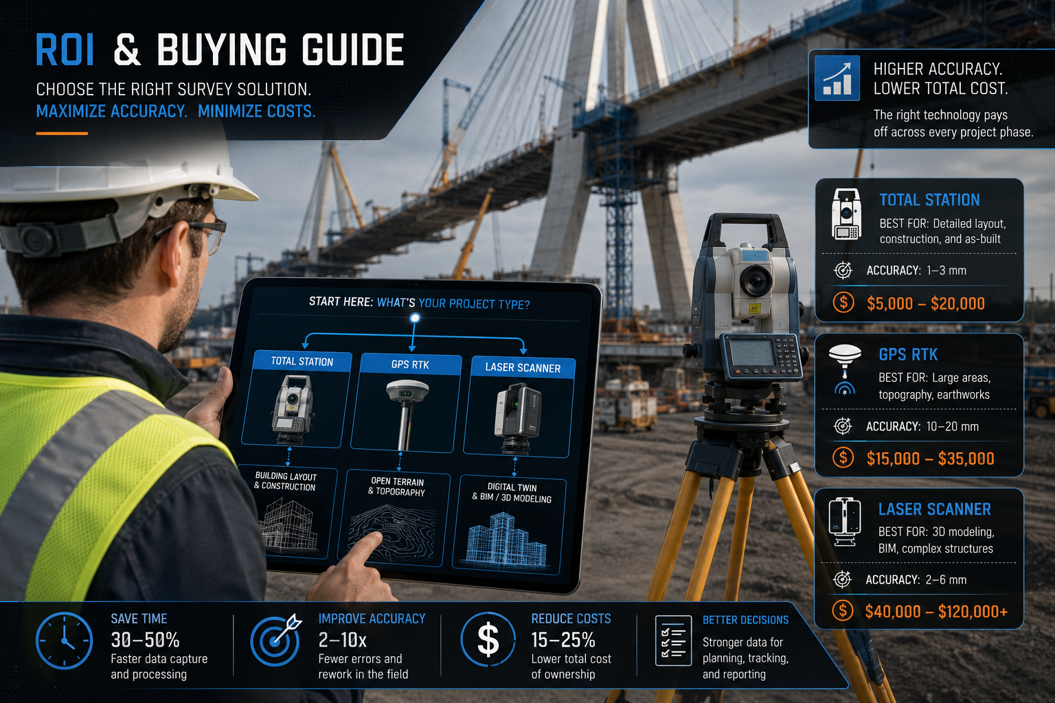
The 2026 Land Survey Equipment Boom: Comparing Total Stations, GPS RTK, and Laser Scanners — Side by Side
| Feature | Total Station | GPS RTK | Laser Scanner |
|---|---|---|---|
| Accuracy | ±1–5mm | ±10–20mm | ±2–6mm |
| Speed | Moderate | Fast | Very fast (point capture) |
| Area coverage | Small-medium | Large | Medium-large |
| Indoor/tunnel use | ✅ Yes | ❌ No | ✅ Yes |
| One-person operation | Robotic only | ✅ Yes | ✅ Yes |
| BIM/digital twin output | Limited | Limited | ✅ Excellent |
| Entry cost | £3,000+ | £5,000+ | £20,000+ |
| Best for | Layout, control | Topo, corridors | As-built, heritage |
The Three-Pillar Workflow
Leading surveying firms in 2026 increasingly adopt a three-pillar workflow [6]:
- Robotic total station → High-accuracy setting-out, monitoring, control
- GNSS/RTK rover → Rapid data capture across large extents
- Terrestrial/mobile laser scanner → Dense point clouds, digital twins, as-builts
This is not about budget. It is about matching the instrument to the task. A firm that only owns one type of instrument will either over-engineer simple jobs or under-deliver on complex ones.
Buying Guide: How to Choose the Right Equipment in 2026
Step 1: Audit Your Project Mix
Before spending a pound, map your last 12 months of projects by type:
- >60% layout and control work → Prioritise a robotic total station
- >60% topographic or corridor surveys → RTK rover is your core tool
- Significant BIM or as-built work → Budget for a scanner or scanner hire
Step 2: Assess Your Environment
| Environment | Recommended Primary Tool |
|---|---|
| Open farmland / coastal | GPS RTK |
| Urban construction site | Robotic total station |
| Tunnel / underground | Total station |
| Heritage building | Laser scanner |
| Mixed infrastructure | All three (integrated workflow) |
Step 3: Consider Brand Ecosystem
In 2026, the top brands are Trimble, Topcon, Hexagon (Leica Geosystems), and Hemisphere GNSS [3]. Staying within one ecosystem simplifies software integration, data workflows, and support contracts. GeoMax offers strong value for firms entering the market or expanding capacity on a tighter budget [3].
Step 4: Calculate Your ROI
Use this simple framework:
Payback Period = Equipment Cost ÷ (Daily Labour Saving × Working Days Per Year)
Example: A £25,000 robotic total station saving one person-day (£450) per working day, used 120 days per year:
- Annual saving: £54,000
- Payback: 5.6 months ✅
For firms considering a full equipment upgrade, exploring surveying resources and market insights can help contextualise investment decisions within broader property and construction market trends.
Step 5: Factor in Software and Training
Hardware is only part of the cost. Budget for:
- Field software licences: £500–£3,000/year
- Office processing software: £1,500–£8,000/year
- Training: 2–5 days per instrument, £500–£2,000 per person
- Support contracts: 10–15% of hardware cost annually
What the 2026 Land Survey Equipment Boom Means for Property Professionals
The 2026 Land Survey Equipment Boom: Comparing Total Stations, GPS RTK, and Laser Scanners is not just a story for field surveyors. It has direct implications for anyone commissioning survey work:
- Higher data quality — Modern instruments produce richer, more accurate datasets that feed directly into Level 3 building surveys and structural assessments.
- Faster turnaround — RTK and scanning workflows compress site time, reducing project costs.
- Better documentation — Point clouds and digital twins support building inspections and surveys for homeowners with unprecedented spatial detail.
- Informed procurement — Understanding the tools behind a survey report helps clients ask the right questions and evaluate quotes more effectively.
For property owners and developers, working with surveyors who deploy the right instrument mix — not just the cheapest option — is a direct investment in data quality and decision confidence. Chartered surveyors across Richmond, Ealing, and Hertfordshire are already integrating these advanced workflows into their service offerings.
Conclusion: Actionable Next Steps for 2026
The global land survey equipment market is in a genuine boom phase — and the firms that thrive will be those that treat total stations, GPS RTK, and laser scanners as complementary tools, not competing ones [6][9].
Here is what to do right now:
- Audit your project mix — Identify which instrument type would deliver the greatest ROI for your current workload.
- Request demos — Trimble, Topcon, and Leica all offer field demonstrations. Test before you buy.
- Start with your biggest gap — If layout accuracy is costing you time, go robotic. If topo speed is the bottleneck, invest in RTK. If BIM deliverables are growing, plan for scanning.
- Build toward the three-pillar workflow — Even if budget means phasing purchases over two to three years, have a roadmap.
- Invest in training — Equipment without trained operators delivers neither accuracy nor efficiency.
- Commission surveys from firms using the right tools — Whether for building surveys or infrastructure documentation, the instrument behind the data matters.
The 2026 land survey equipment boom is creating real competitive advantages for firms that move decisively. The question is not whether to invest — it is which instrument to prioritise first.
References
[1] Global Land Survey Equipment Market Outlook 2026 2036 Infrastructure Boom Drives Precision Mapping Demand – einpresswire.com
[3] Best Surveying Equipment Brands – rtkgpssurveyequipment.com
[4] Navigating 2026 Land Survey Equipment Market Growth Top Tools For Infrastructure Projects 2 – wimbledonsurveyors.com
[5] Comparing The Top Surveying Equipment – harpersurveying.com
[6] Navigating The 2026 Land Survey Equipment Boom Total Stations Gps And Laser Scanners Reviewed – nottinghillsurveyors.com
[8] Are Conventional Total Stations Still Commonly – reddit.com
[9] Surveying – topconpositioning.com
[10] History Of Surveying Equipment In America – datumtechsolutions.com