The UK property market is experiencing a technological revolution in 2026, driven by updated RICS Home Survey Standards and new homebuying reforms that demand unprecedented accuracy in property assessments. Integrating 3D laser scanning in Level 3 building surveys has emerged as the gold standard for detecting defects and providing comprehensive property documentation, especially as mandatory upfront assessments become the norm. This transformative technology captures millions of data points per second, creating detailed digital twins of properties that reveal hidden structural issues traditional methods might miss.
For homebuyers, sellers, and surveyors navigating the 2026 reforms, understanding how 3D laser scanning enhances survey accuracy isn't just beneficial—it's essential. This comprehensive guide explores the practical implementation, benefits, and real-world applications of this cutting-edge technology in Level 3 building surveys.
Key Takeaways
- 🎯 3D laser scanning achieves millimeter-level accuracy in building documentation, detecting defects invisible to traditional survey methods
- 📊 2026 homebuying reforms emphasize mandatory upfront property assessments, making comprehensive Level 3 surveys with advanced technology increasingly valuable
- ⚡ Efficiency gains include 40-60% faster data collection compared to conventional surveying techniques while capturing exponentially more detail
- 💰 Cost-effectiveness emerges through reduced revisit requirements, fewer post-purchase surprises, and comprehensive documentation for budgeting repairs and restoration
- 🏗️ Integration with BIM (Building Information Modeling) enables seamless project planning and future renovation work
Understanding Level 3 Building Surveys in the 2026 Context
What Makes Level 3 Surveys Essential
A Level 3 building survey represents the most comprehensive property inspection available in the UK market. Unlike basic homebuyer reports, these detailed assessments examine every accessible aspect of a property's construction, condition, and potential defects. The survey is particularly recommended for:
- Properties built before 1900
- Buildings with unusual construction methods
- Properties requiring significant renovation
- Homes that have been substantially altered or extended
- Listed buildings or those in conservation areas
The difference between Level 2 and Level 3 surveys becomes critical when considering older or complex properties where hidden defects could represent substantial financial risk.
The 2026 Homebuying Reform Landscape
Recent regulatory changes in 2026 have transformed the UK property transaction process. The updated RICS Home Survey Standards now emphasize:
- Enhanced defect detection requirements 📋
- Digital documentation standards 💻
- Comprehensive condition reporting 📊
- Technology-assisted accuracy verification ✅
These reforms aim to reduce post-purchase disputes and provide buyers with transparent, detailed property information before commitment. The shift toward mandatory upfront assessments means surveyors must deliver more comprehensive, defensible reports backed by verifiable data.
How 3D Laser Scanning Transforms Level 3 Building Surveys
The Technology Behind the Accuracy
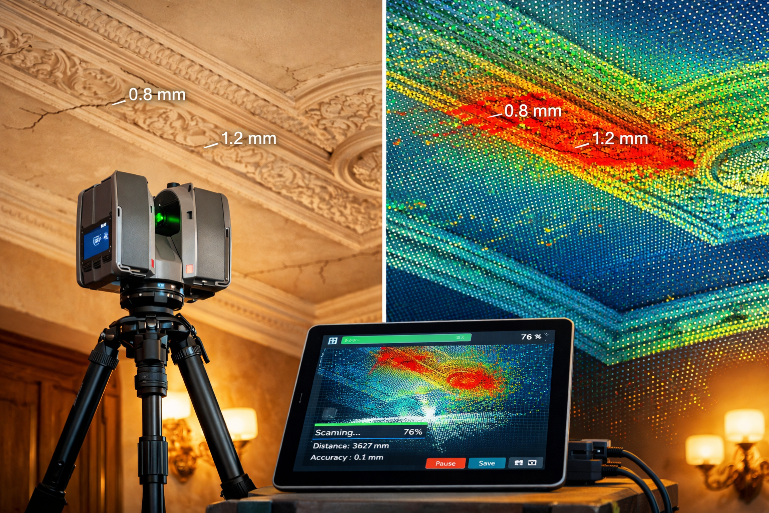
3D laser scanning, also known as LiDAR (Light Detection and Ranging), works by emitting rapid laser pulses that bounce off surfaces and return to the scanner. The device measures the time taken for each pulse to return, calculating precise distances and creating a "point cloud"—a collection of millions of spatial data points that form a detailed three-dimensional representation of the building [1].
Modern laser scanners used in building surveys can capture:
- 350,000+ points per second with accuracy to ±2mm
- 360-degree panoramic imagery with integrated photography
- Measurements from distances of 0.5m to 300m
- Color information for visual context and defect identification
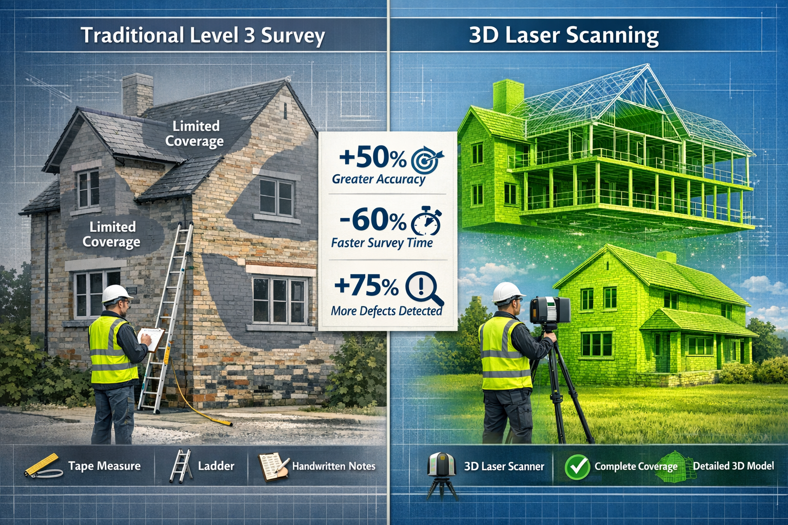
Key Advantages Over Traditional Survey Methods
| Traditional Survey Method | 3D Laser Scanning Method |
|---|---|
| Manual measurements with tape/laser | Automated capture of millions of measurements |
| Limited documentation of complex geometry | Complete digital record of all surfaces |
| Potential for human measurement error | Consistent, repeatable accuracy |
| Difficult to verify measurements post-survey | Permanent digital archive for verification |
| Time-consuming for complex structures | Rapid data capture (2-4 hours for typical property) |
| Limited detail in hard-to-reach areas | Comprehensive coverage including difficult spaces |
The integration of laser scanning with building pathology expertise allows surveyors to identify subtle structural movements, deformations, and defects that traditional methods might overlook [2].
Enhanced Defect Detection Capabilities
Integrating 3D laser scanning in Level 3 building surveys dramatically improves defect detection through:
Structural Movement Analysis 🏗️
Point cloud data reveals even minor deviations from vertical or horizontal planes, indicating potential structural issues like subsidence, settlement, or wall bulging. Measurements accurate to 2mm can detect movement that's invisible to the naked eye.
Hidden Cavity Detection 🔍
By comparing expected wall thicknesses with scanned data, surveyors can identify voids, concealed spaces, or areas where materials have deteriorated internally.
Moisture and Damp Mapping 💧
When combined with thermal imaging, laser scanning provides precise location data for environmental issues like damp penetration, showing exactly where problems exist within the building envelope.
Roof and Ceiling Defects 🏠
Scanning eliminates the need for physical access to dangerous or inaccessible areas. Detailed point clouds reveal sagging, deformation, or structural concerns in roof spaces and high ceilings without requiring scaffolding.
Practical Implementation: Integrating 3D Laser Scanning in Level 3 Building Surveys for 2026 Compliance
The Survey Process with Laser Scanning Integration
Implementing 3D laser scanning within a Level 3 building survey follows a structured workflow:
1. Pre-Survey Planning 📋
- Site assessment and access evaluation
- Identification of areas requiring further investigation
- Equipment selection based on property characteristics
- Coordination with property owners regarding building surveyor access
2. On-Site Data Capture ⚡
The surveyor positions the laser scanner at strategic locations throughout the property, typically:
- External scans: 8-12 positions for a standard detached house
- Internal scans: 15-25 positions covering all rooms and circulation spaces
- Scan time: 3-5 minutes per position
- Total on-site time: 3-6 hours depending on property size
Traditional survey observations continue alongside scanning, with the surveyor noting:
- Material conditions
- Visible defects
- Moisture readings
- Building regulation compliance concerns
3. Data Processing and Analysis 💻
Post-survey processing transforms raw scan data into actionable intelligence:
- Point cloud registration: Aligning multiple scans into a unified model
- Noise filtering: Removing erroneous data points
- Measurement extraction: Calculating dimensions, areas, and volumes
- Defect identification: Analyzing deviations and anomalies
- 2D drawing generation: Creating floor plans and elevations
- 3D model creation: Building BIM-compatible digital representations [3]
4. Report Generation and Deliverables 📊
The comprehensive Level 3 survey report includes:
- Traditional narrative survey findings
- Laser-scanned measurements and verification data
- 3D visualizations showing defect locations
- Point cloud data files for future reference
- 2D CAD drawings showing accurate as-built conditions
- Photographic evidence with spatial context
Cost-Benefit Analysis for 2026 Homebuyers
Integrating 3D laser scanning in Level 3 building surveys represents an investment that delivers measurable returns:
Initial Cost Considerations 💷
- Standard Level 3 survey: £800-£1,500
- 3D laser scanning enhancement: Additional £400-£800
- Total investment: £1,200-£2,300 for comprehensive assessment
Financial Benefits 💰
- Negotiation leverage: Documented defects support price reductions averaging £15,000-£25,000
- Avoided costs: Early detection prevents post-purchase surprises averaging £8,000-£40,000
- Insurance claims: Precise documentation supports claims and reduces disputes
- Future planning: Accurate measurements eliminate costly re-surveys for renovations [2]
Time Savings ⏱️
- Reduced revisits: Comprehensive first-time capture eliminates return trips
- Faster decision-making: Clear visual data accelerates buyer confidence
- Streamlined renovations: Ready-to-use measurements speed up planning applications
For those wondering which building survey they need, properties with complexity, age, or renovation potential justify the enhanced Level 3 approach with laser scanning integration.
Technology Integration and Future-Proofing Your Property Assessment
BIM Integration and Digital Twin Creation
Building Information Modeling (BIM) integration represents a significant advantage of laser scanning technology. The point cloud data seamlessly converts into intelligent 3D models that serve multiple purposes:
- Renovation planning: Architects work directly from accurate as-built models
- Structural analysis: Engineers assess load-bearing capacity with precise geometry
- Facilities management: Property owners maintain comprehensive digital records
- Heritage preservation: Listed buildings receive detailed documentation for conservation [3]
The 2026 emphasis on digital documentation aligns perfectly with BIM workflows, ensuring survey data remains valuable throughout the property's lifecycle.
Complementary Technologies
Modern Level 3 surveys often combine laser scanning with other advanced technologies:
Drone Surveys 🚁
Premium drone surveys complement ground-based laser scanning by:
- Capturing roof conditions without physical access
- Documenting chimney stacks and high-level details
- Providing aerial context for site conditions
- Identifying drainage and boundary issues
Thermal Imaging 🌡️
Infrared cameras detect:
- Heat loss and insulation deficiencies
- Hidden moisture penetration
- Electrical hotspots indicating potential hazards
- Air leakage points affecting energy efficiency
Ground Penetrating Radar 📡
For comprehensive assessments, GPR technology reveals:
- Underground drainage systems
- Foundation depths and conditions
- Buried services and utilities
- Soil conditions affecting stability
Understanding Survey Timelines with Advanced Technology
One common question is how long a building survey takes. With 3D laser scanning integration:
- On-site inspection: 4-8 hours (versus 3-6 hours traditional)
- Data processing: 2-3 days
- Report preparation: 5-7 days
- Total turnaround: 7-10 working days
While slightly longer than basic surveys, the comprehensive nature and accuracy justify the timeframe, especially given the consequences of failing to act on property defects discovered too late.
Best Practices for Homebuyers and Property Professionals
Selecting the Right Surveyor
When seeking integrating 3D laser scanning in Level 3 building surveys services, consider:
✅ RICS Accreditation: Ensure chartered surveyor status
✅ Technology Investment: Verify use of professional-grade equipment
✅ Experience: Request examples of previous laser-scanned surveys
✅ Deliverables: Clarify what data formats you'll receive
✅ Insurance: Confirm professional indemnity coverage
Recent guidance on 5 best building surveyors for accurate 3D laser scanning emphasizes the importance of proven track records with the technology [4].
Maximizing Survey Value
To get the most from your enhanced Level 3 survey:
- Provide complete access: Ensure all areas are accessible, including lofts, cellars, and outbuildings
- Share renovation plans: Inform the surveyor of intended alterations for targeted assessment
- Request specific focus areas: Highlight concerns about particular building elements
- Ask about data retention: Understand how long point cloud data remains available
- Plan for future use: Consider how survey data supports maintenance planning
Common Misconceptions About 3D Laser Scanning
❌ Myth: "Laser scanning replaces the surveyor's expertise"
✅ Reality: Technology enhances but doesn't replace professional judgment and experience
❌ Myth: "Point clouds show everything, including hidden defects"
✅ Reality: Scanning captures visible surfaces; invasive investigation may still be needed
❌ Myth: "3D scanning is only for commercial or heritage buildings"
✅ Reality: Residential properties benefit significantly, especially older or complex homes
❌ Myth: "The technology is too expensive for typical homebuyers"
✅ Reality: Cost savings from defect detection typically exceed the survey premium [5]
Real-World Applications and Case Studies
Period Property Assessment
A Victorian terraced house in London underwent a Level 3 survey with 3D laser scanning before purchase. The technology revealed:
- 2.3cm outward lean in the rear wall, indicating tie bar failure
- Irregular floor levels suggesting historic settlement
- Roof structure deformation invisible from ground level
- Precise measurements for planning a loft conversion
The buyer negotiated a £22,000 price reduction based on documented findings and proceeded with confidence, using the scan data for subsequent renovation planning [6].
Listed Building Documentation
A Grade II listed Georgian townhouse required comprehensive assessment for insurance and conservation purposes. Laser scanning provided:
- Millimeter-accurate records of ornate plasterwork and architectural features
- Structural movement analysis showing historic settlement patterns
- Complete documentation for heritage compliance
- Digital archive for future restoration reference
The property owner used the data to secure appropriate insurance coverage and plan sympathetic repairs that respected the building's character.
New Build Snagging
Even modern properties benefit from laser scanning technology. A 2025-built detached house underwent scanning that identified:
- Floor level variations exceeding building regulation tolerances
- Wall plumb deviations indicating poor construction quality
- Window and door misalignments affecting weather-tightness
- Dimensional discrepancies from approved plans
The comprehensive documentation supported warranty claims and ensured defects were rectified before final completion.
Regulatory Compliance and Professional Standards
RICS Standards and 3D Technology
The Royal Institution of Chartered Surveyors (RICS) has updated guidance recognizing the role of advanced technology in building surveys. The 2026 standards emphasize:
- Accuracy verification: Technology-assisted measurements provide defensible data
- Comprehensive documentation: Digital records support thorough reporting
- Professional competence: Surveyors must demonstrate technology proficiency
- Client communication: Clear explanation of technology benefits and limitations
Data Management and GDPR
Laser scanning generates substantial data requiring proper management:
- Storage: Point clouds typically range from 2GB to 20GB per property
- Retention: Professional standards recommend 6-15 year retention periods
- Privacy: Scanning may capture neighboring properties, requiring careful data handling
- Access: Clients should receive agreed data formats and usage rights
Quality Assurance Protocols
Professional surveying practices implementing 3D laser scanning maintain rigorous quality standards:
- Equipment calibration: Regular testing ensures accuracy maintenance
- Scan coverage verification: Systematic checking prevents data gaps
- Registration accuracy: Point cloud alignment verified to tolerance standards
- Deliverable review: Independent checking before client release
- Continuous professional development: Ongoing training in evolving technology [1]
Conclusion: Embracing Technology for Confident Property Decisions
Integrating 3D laser scanning in Level 3 building surveys represents more than technological advancement—it's a fundamental shift toward data-driven property assessment that aligns perfectly with 2026 homebuying reforms. The millimeter-level accuracy, comprehensive documentation, and enhanced defect detection capabilities provide buyers, sellers, and property professionals with unprecedented confidence in property transactions.
As mandatory upfront assessments become standard practice, the combination of traditional surveying expertise and cutting-edge laser scanning technology delivers the thorough, defensible property intelligence the modern market demands. The investment in enhanced survey technology typically pays for itself many times over through negotiation leverage, avoided post-purchase surprises, and streamlined renovation planning.
Next Steps for Homebuyers and Property Owners
If you're considering a property purchase or need comprehensive assessment of an existing building:
- Consult with RICS chartered surveyors experienced in 3D laser scanning technology
- Request detailed information about survey deliverables and data formats
- Consider the property characteristics that benefit most from enhanced surveying
- Plan how survey data will support future building inspections and maintenance
- Budget appropriately for comprehensive assessment that protects your investment
The future of property surveying has arrived in 2026, combining human expertise with technological precision to deliver the comprehensive, accurate assessments that modern property transactions require. Whether you're buying a period property, planning major renovations, or simply seeking peace of mind about your investment, 3D laser scanning-enhanced Level 3 surveys provide the detailed intelligence you need to make confident decisions.
For more information about types of building surveys available and which approach best suits your needs, consult with qualified professionals who can guide you through the options and deliver the comprehensive assessment your property deserves.
References
[1] 3d%20laser%20scanning%20in%20building%20construction%20comprehensive%20guide – https://www.designingbuildings.co.uk/wiki/3D%20Laser%20Scanning%20in%20Building%20Construction%20Comprehensive%20Guide
[2] 3d Laser Scanning In Construction Cost Savings – https://www.pointscan.co.uk/3d-laser-scanning-in-construction-cost-savings/
[3] 3d Laser Scanning Bim – https://curasurveys.co.uk/3d-laser-scanning-bim/
[4] 5 Best Building Surveyors For Accurate 3d Laser Scanning – https://theedinburghreporter.co.uk/2026/02/5-best-building-surveyors-for-accurate-3d-laser-scanning/
[5] 3d Laser Scanning For Property Surveys From Adoption Boom To Practical Implementation – https://nottinghillsurveyors.com/blog/3d-laser-scanning-for-property-surveys-from-adoption-boom-to-practical-implementation
[6] 3d Laser Scanning The Process Deliverables – https://terrainsurveys.co.uk/news-and-media/3d-laser-scanning/3d-laser-scanning-the-process-deliverables