Property boundary disputes have plagued landowners, developers, and surveyors for centuries. A fence line positioned just inches off the true boundary can trigger costly legal battles, delay construction projects, and erode trust between neighbors. In 2026, however, the landscape of property boundary surveys is experiencing a revolutionary transformation. GNSS enhancements for centimeter-level precision are fundamentally changing how professionals delineate property lines, resolve boundary disputes, and conduct title work with unprecedented accuracy.
Modern Global Navigation Satellite System (GNSS) technology now delivers real-time data with centimeter-level accuracy, enabling surveyors to establish property boundaries with confidence levels that were unimaginable just a decade ago.[1] This technological leap forward addresses one of the most persistent challenges in real estate: determining exactly where one property ends and another begins. For field crews working on disputed boundaries, title verification, and development projects, understanding and implementing GNSS enhancements for centimeter-level precision in property boundary surveys has become essential for competitive advantage and professional credibility.
Key Takeaways
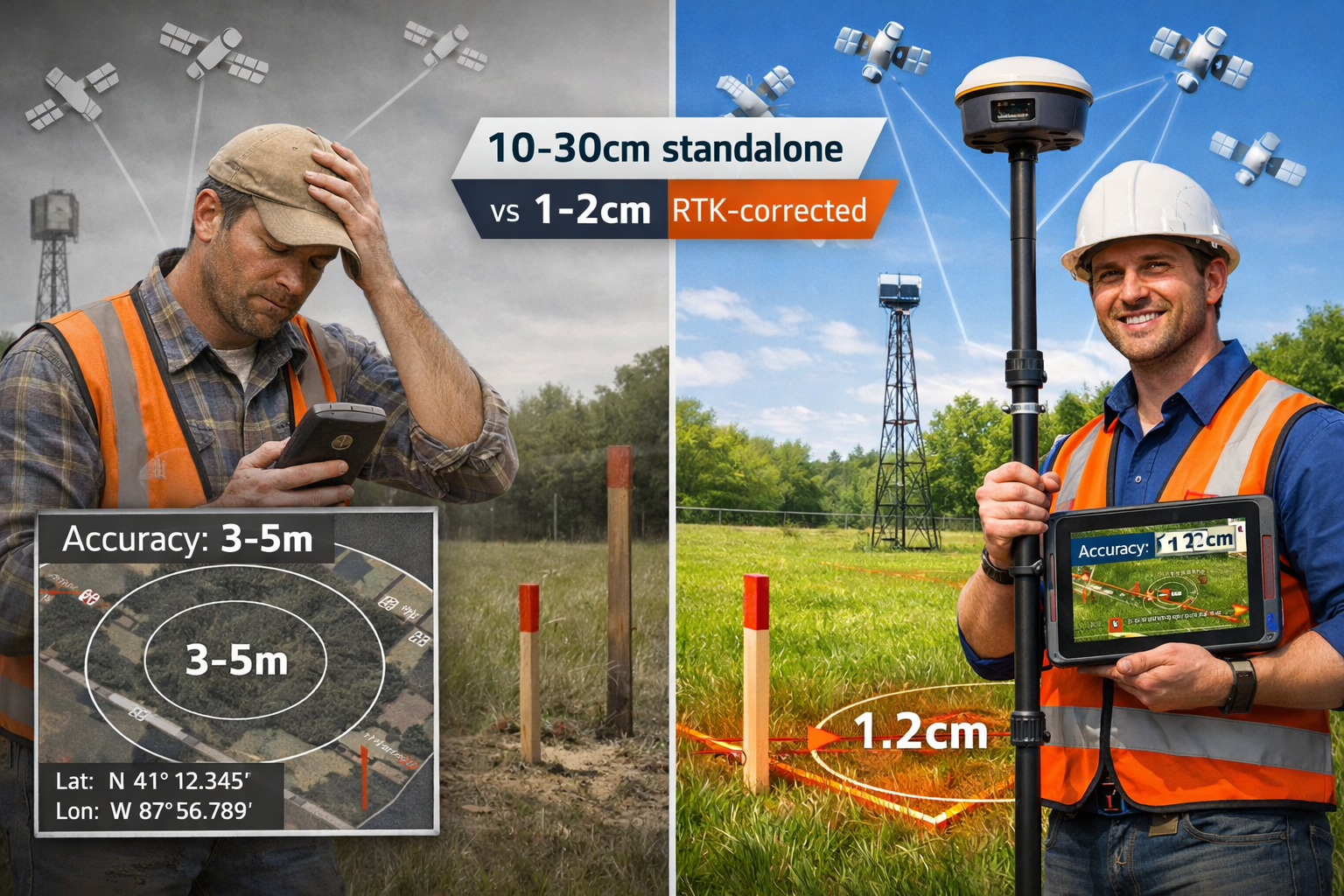
- 🎯 Modern GNSS RTK systems deliver 1-2 cm accuracy for property boundary surveys when using real-time kinematic corrections, compared to 10-30 cm accuracy in standalone mode[3]
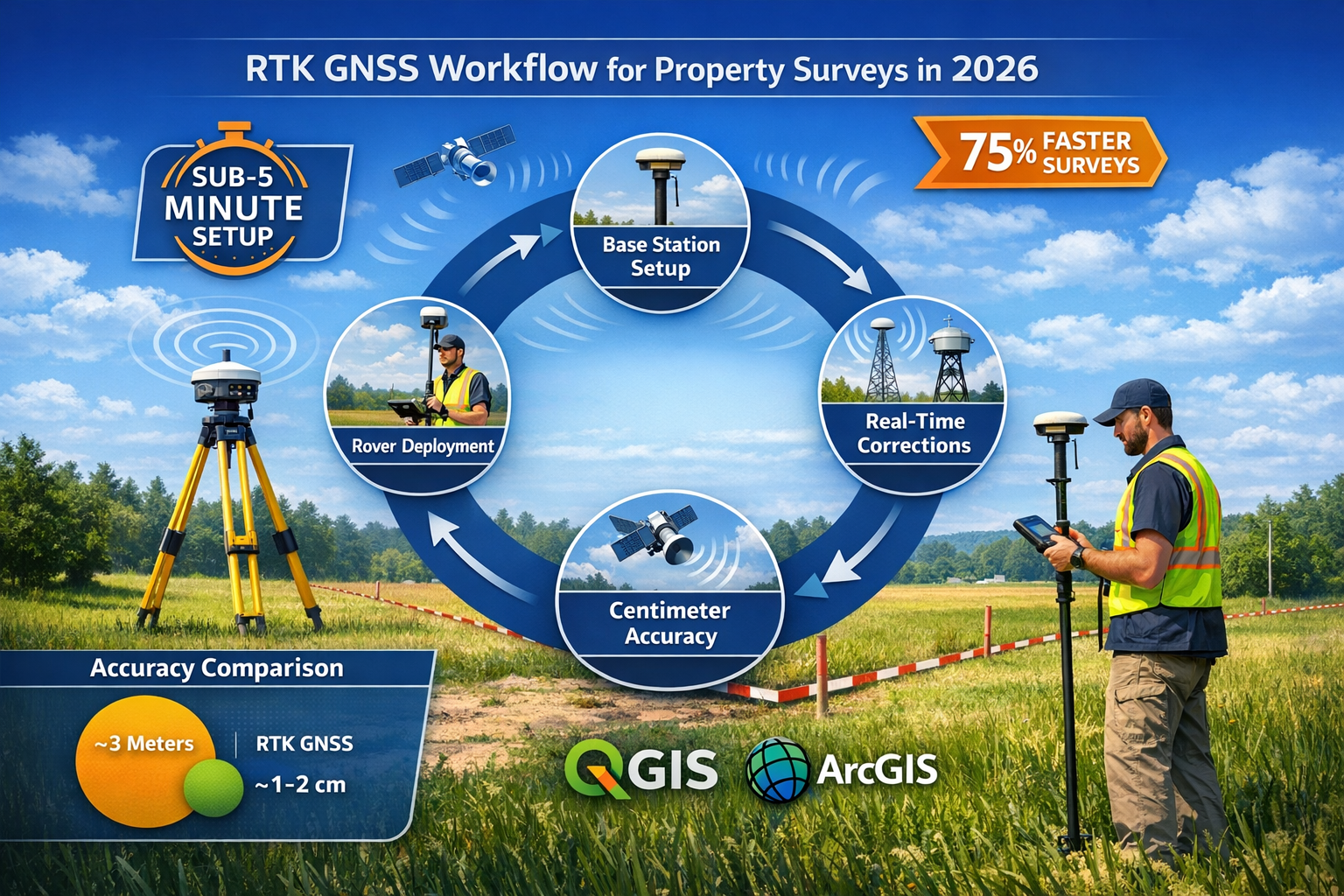
- ⚡ Survey workflows are 75% faster with current GNSS technology, reducing operational costs by 40-60% compared to traditional surveying methods[7]
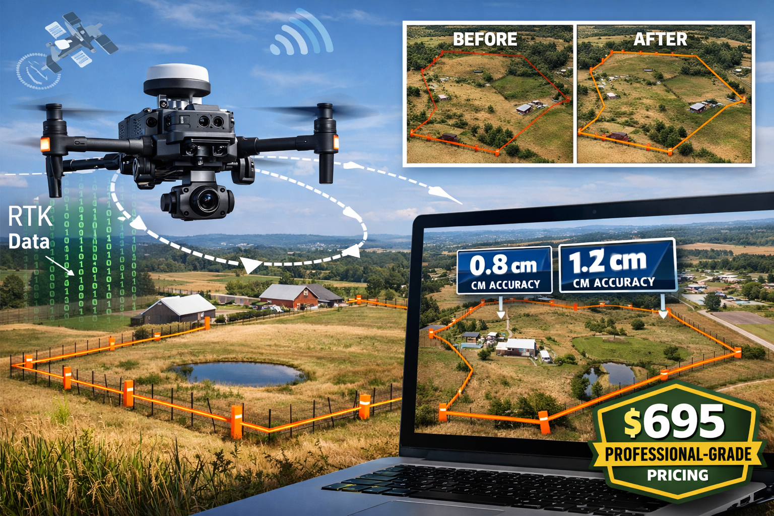
- 💰 Professional-grade GNSS receivers now start at $695, democratizing access to survey-grade centimeter accuracy that previously required five-figure investments[2]
- 🚁 Autonomous drone integration with multi-sensor GNSS systems enables comprehensive boundary surveys of large properties in a single flight, replacing multiple site visits[1]
- 📊 Seamless GIS integration allows field crews to incorporate centimeter-accurate GNSS data directly into QGIS and ArcGIS workflows without complex configuration[3]
Understanding GNSS Technology for Property Boundary Applications
What Makes GNSS Different from Traditional GPS
Many property professionals still refer to satellite positioning as "GPS," but this terminology reflects outdated technology. Global Navigation Satellite Systems (GNSS) represent the collective term for all satellite navigation systems, including the United States' GPS, Russia's GLONASS, Europe's Galileo, and China's BeiDou constellation. Modern GNSS receivers access signals from multiple satellite systems simultaneously, dramatically improving accuracy, reliability, and performance in challenging environments.
Traditional GPS receivers, which access only the U.S. GPS constellation, typically achieve accuracy in the 3-5 meter range under optimal conditions. This level of precision proves completely inadequate for property boundary work, where disputes often center on inches rather than feet. In contrast, GNSS enhancements for centimeter-level precision leverage signals from 100+ satellites across multiple constellations, providing redundancy and geometric diversity that enable sub-centimeter positioning.[6]
The RTK Revolution in Boundary Surveying
Real-Time Kinematic (RTK) technology has fundamentally transformed property boundary surveys by enabling centimeter-level accuracy in real-time field conditions. RTK GNSS has delivered 1-centimeter accuracy for over 20 years through a base station and rover system architecture.[6] The base station occupies a known position and calculates correction data by comparing its known location with satellite-derived positions. These corrections transmit wirelessly to the rover unit, which applies them to achieve centimeter-level positioning.
What has changed dramatically in 2026 is the accessibility and ease of deployment of RTK systems. Traditional RTK implementations required extensive technical knowledge, complex configuration procedures, and significant capital investment. Modern systems have collapsed these barriers—setup time has been reduced to under five minutes (power on, connect, survey), eliminating the overhead and error potential of traditional deployment.[2]
The global High Precision GNSS Receiver market reflects this transformation, valued at $1,552 million in 2025 and projected to reach $2,523 million by 2034, driven primarily by increasing demand for centimeter-level accuracy across surveying, construction, and agriculture sectors.[5] Understanding why property owners hire surveyors has evolved alongside these technological capabilities.
Dual-Frequency and Multi-Constellation Advantages
Advanced GNSS receivers in 2026 utilize dual-frequency signal processing, accessing both L1 and L5 frequency bands from multiple satellite constellations. This dual-frequency capability provides critical advantages for property boundary work:
- Ionospheric error correction: Dual-frequency receivers can calculate and eliminate ionospheric delays that degrade single-frequency positioning
- Multipath mitigation: Processing multiple frequencies reduces errors from signal reflections off buildings, vehicles, and terrain features
- Faster convergence: Dual-frequency RTK systems achieve fixed solutions (centimeter-level accuracy) significantly faster than single-frequency alternatives
- Urban canyon performance: In challenging environments with limited sky visibility, dual-frequency systems maintain accuracy where single-frequency receivers fail
The Carlson BRX7 GNSS receiver exemplifies this evolution, featuring dual RTK GNSS engines that deliver sub-centimeter precision with fast fixed solution acquisition times, even in challenging urban canyon and dense tree canopy environments where traditional GPS struggles.[8]
Implementing GNSS Enhancements for Centimeter-Level Precision in Field Operations
Equipment Selection for Property Boundary Surveys
Selecting appropriate GNSS equipment for property boundary work requires balancing accuracy requirements, budget constraints, and operational workflow. In 2026, surveyors face an unprecedented range of options across multiple price points and capability levels.
Entry-Level Professional Systems ($695-$2,000): Modern entry-level GNSS receivers like the GEO-MEASURE device provide survey-grade centimeter accuracy at consumer-friendly pricing.[2] These systems typically include:
- Single or dual-frequency GNSS receivers
- One-year RTK correction service subscription
- Basic field software for point collection
- Smartphone or tablet connectivity
- 1-2 cm horizontal accuracy with RTK corrections
Mid-Range Survey Systems ($3,000-$8,000): Professional surveyors conducting regular boundary work typically invest in mid-range systems offering:
- Multi-constellation, dual-frequency receivers
- Integrated tilt compensation for rover pole positioning
- Advanced field software with CAD capabilities
- Extended battery life (8-12 hours continuous operation)
- Sub-centimeter accuracy specifications
High-End Precision Systems ($10,000+): Complex boundary disputes, large development projects, and legal survey work may justify premium systems featuring:
- Triple-frequency signal processing
- Advanced multipath rejection algorithms
- Integrated inertial measurement units (IMU)
- Professional surveying software suites
- Millimeter-level accuracy potential
The democratization of GNSS technology means that even small surveying firms and independent professionals can now access centimeter-level precision that was previously exclusive to large organizations with substantial equipment budgets.
RTK Correction Service Options
Achieving centimeter-level accuracy requires real-time correction data transmitted to the rover receiver. In 2026, surveyors can choose from several correction delivery methods:
Base and Rover Systems: Traditional RTK deployments involve establishing a base station at a known point and operating one or more rover units within radio range (typically 5-10 km). This approach provides:
- Complete independence from subscription services
- Consistent accuracy across the survey area
- No ongoing service costs after initial equipment investment
- Requirement for base station setup and calibration
Network RTK Services: Commercial and government RTK networks provide correction data via cellular internet connection, eliminating the need for a dedicated base station. Network RTK offers:
- Immediate deployment without base station setup
- Coverage across large geographic areas
- Subscription-based pricing models
- Dependency on cellular connectivity
Satellite-Based Augmentation: Services like WAAS, EGNOS, and MSAS provide free correction data via satellite broadcast, though typically achieving decimeter rather than centimeter accuracy.
For property boundary surveys, network RTK services have become the dominant choice in 2026 due to their simplified deployment and consistent accuracy. Modern systems reduce setup time to under five minutes, significantly reducing overhead and error in field operations.[2]
Integration with Field Workflows and GIS Systems
The true value of GNSS enhancements for centimeter-level precision emerges when field data integrates seamlessly with office workflows, GIS systems, and legal documentation. Professional GNSS receivers now integrate seamlessly with popular GIS platforms including QGIS and ArcGIS Field Maps, enabling surveyors and GIS professionals to bring survey-grade centimeter accuracy directly into field workflows without complex configuration.[3]
Field-to-Office Workflow in 2026:
- Pre-Survey Planning: Import property descriptions, existing survey data, and aerial imagery into field software
- Field Data Collection: Capture boundary corners, monuments, and features with centimeter-level GNSS positioning
- Real-Time Validation: Verify measurements against property descriptions and adjacent surveys while still on-site
- Automated Documentation: Generate field notes, sketches, and preliminary boundary exhibits automatically
- Office Processing: Export data directly to CAD and GIS platforms for final survey preparation
This integrated workflow eliminates the transcription errors, data format conversions, and processing delays that plagued traditional surveying methods. Measured surveys benefit significantly from these streamlined processes.
Accuracy Verification and Quality Control
Implementing centimeter-level GNSS technology requires robust quality control procedures to ensure positioning accuracy meets project requirements. Professional surveyors in 2026 employ several verification methods:
Occupation Time Standards: Even with RTK corrections, adequate satellite observation time ensures reliable positioning. Best practices include:
- Minimum 5-second occupation for routine boundary points
- 30-60 second occupation for critical property corners
- Multiple independent observations of disputed boundary locations
Fixed Solution Verification: RTK systems operate in either "float" or "fixed" solution modes. Only fixed solutions provide centimeter-level accuracy. Field crews must verify fixed solution status before accepting each observation.
Independent Check Measurements: Traditional surveying principles remain relevant—verify GNSS positions with independent measurements:
- Measure distances between boundary corners with total station or tape
- Compare GNSS-derived angles with total station observations
- Occupy known control points to verify system accuracy
Multipath Detection: Urban and wooded environments can introduce multipath errors despite advanced receiver technology. Surveyors should:
- Avoid observations near large reflective surfaces when possible
- Collect multiple observations at different times
- Compare GNSS positions with traditional measurements for critical points
When deployed as standalone receivers, modern GNSS systems achieve 10-30 cm accuracy; when paired with RTK corrections, the same systems deliver 1-2 cm accuracy for property boundary surveys.[3] Understanding this distinction helps field crews recognize when RTK corrections are functioning properly.
Practical Applications: GNSS Enhancements for Centimeter-Level Precision in Boundary Dispute Resolution
Resolving Fence Line Disputes with Centimeter Accuracy
Fence line disputes represent one of the most common boundary conflicts between property owners. A fence constructed along an assumed property line may encroach several feet onto a neighbor's property, creating legal complications and relationship tensions. GNSS enhancements for centimeter-level precision provide objective, defensible data for resolving these disputes.
Case Study Scenario: Two residential property owners dispute the location of their common boundary. An existing fence has stood for 15 years, but recent property sales have raised questions about whether the fence aligns with the legal boundary description.
Traditional Approach: A surveyor would establish control from distant benchmarks, traverse to the property, measure to existing monuments (if found), and attempt to retrace the original survey. This process typically required:
- Multiple site visits for reconnaissance and surveying
- 6-8 hours of field time
- 4-6 hours of office calculation and drafting
- Total project cost: $2,500-$4,000
2026 GNSS Approach: Using modern RTK GNSS technology, the surveyor:
- Reviews property descriptions and existing surveys in the office
- Arrives on-site with GNSS rover and tablet
- Powers on equipment and establishes RTK connection (under 5 minutes)[2]
- Locates existing property corners or monuments with centimeter accuracy
- Sets new boundary markers at calculated corner positions
- Measures fence offset from true boundary line
- Documents findings with photos, coordinates, and field notes
- Returns to office with complete data for final survey preparation
Results: Field time reduced to 2-3 hours, office time reduced to 2-3 hours, total project cost reduced by 40-60%[7], and property owners receive objective data showing the fence is 1.3 feet (40 cm) onto the eastern property.
The centimeter-level precision eliminates ambiguity—there's no question about where the legal boundary exists relative to the fence. This clarity often facilitates settlement without litigation.
Title Work and Boundary Verification for Real Estate Transactions
Real estate transactions depend on accurate property descriptions and boundary verification. Title companies, attorneys, and lenders increasingly require boundary surveys to identify potential encroachments, easement violations, and description errors before closing. GNSS technology has transformed this critical due diligence process.
Boundary Survey Requirements: A comprehensive boundary survey for title work typically includes:
- Location of all property corners with coordinates
- Identification of encroachments (buildings, fences, driveways)
- Verification of easements and rights-of-way
- Comparison of physical boundaries with legal descriptions
- Documentation of monuments, markers, and boundary evidence
GNSS Advantages for Title Surveys:
- Speed: Survey professionals are achieving 75% faster surveys with modern GNSS RTK systems[7]
- Accuracy: Centimeter-level positioning eliminates disputes about minor encroachments
- Documentation: Coordinate data provides permanent record of boundary positions
- Repeatability: Future surveyors can return to exact corner positions using coordinates
- Legal Defensibility: RTK GNSS data provides objective evidence in boundary disputes
For properties with complex boundary descriptions, multiple easements, or irregular shapes, GNSS technology enables surveyors to efficiently verify that physical conditions match legal descriptions. This verification protects buyers, sellers, and lenders from undisclosed boundary problems that could emerge after closing.
Building surveys and boundary surveys often complement each other in comprehensive property due diligence.
Large-Scale Development and Subdivision Layout
Development projects and subdivisions require establishing dozens or hundreds of property corners with precision and efficiency. GNSS enhancements for centimeter-level precision have revolutionized large-scale boundary layout work.
Subdivision Layout Workflow:
Traditional subdivision layout required establishing a dense control network, traversing to each lot corner, and setting monuments through time-intensive total station procedures. A 50-lot subdivision might require:
- 2-3 weeks of field survey work
- Multiple crew members
- Extensive calculations and error checking
- Significant equipment mobilization
Modern GNSS Subdivision Layout:
Using RTK GNSS technology with network corrections, a two-person crew can:
- Upload subdivision plat coordinates to field controller
- Navigate directly to each lot corner position
- Set monuments with centimeter accuracy
- Document as-built corner positions
- Complete 50-lot subdivision in 3-5 days
Autonomous Drone Integration: For large agricultural, commercial, and development-scale properties requiring boundary surveys, multi-sensor drones now provide unprecedented clarity and detail for property delineation.[1] Autonomous surveying drones with predictive modeling-based flight path planning and automatic adjustment of altitude, angle, and sensor selection can reduce what previously required multiple site visits to a single highly detailed flight.[1]
This efficiency transformation has profound implications for development costs and project timelines. Faster boundary establishment means earlier construction starts, reduced carrying costs, and improved project economics.
Easement and Right-of-Way Documentation
Utility easements, access rights-of-way, and conservation easements require precise documentation to prevent conflicts between property owners and easement holders. GNSS technology enables accurate easement boundary establishment and verification.
Utility Easement Verification: A property owner discovers that a utility company has installed underground infrastructure that may extend beyond the recorded easement boundaries. Using RTK GNSS, a surveyor can:
- Establish the easement boundary corners from the legal description
- Locate utility infrastructure with electromagnetic locating equipment
- Document the relationship between easement boundaries and actual utilities
- Provide objective data for easement violation assessment
Conservation Easement Monitoring: Conservation organizations use easements to protect environmentally sensitive lands. GNSS technology enables:
- Precise documentation of easement boundaries
- Monitoring of land use within easement areas
- Detection of encroachments or violations
- Long-term tracking of easement compliance
The coordinate-based documentation provided by GNSS systems creates a permanent record that future surveyors, property owners, and easement holders can reference decades later.
Advanced GNSS Techniques for Challenging Boundary Survey Environments
Urban Canyon and Obstructed Sky Visibility
Property boundary surveys in urban environments present unique challenges for GNSS positioning. Tall buildings create "urban canyons" where satellite visibility is limited, signals reflect off structures (multipath), and positioning accuracy degrades significantly.
Traditional GPS Performance in Urban Environments: Single-frequency GPS receivers often fail completely in urban canyons, unable to achieve any position solution or producing positions with errors of 10-50 meters.
Modern GNSS Solutions for Urban Boundaries:
Advanced dual RTK GNSS engines deliver sub-centimeter precision with fast fixed solution acquisition times, even in challenging urban canyon and dense tree canopy environments.[8] Key technologies enabling this performance include:
- Multi-constellation access: Utilizing GPS, GLONASS, Galileo, and BeiDou increases satellite availability in obstructed environments
- Dual-frequency processing: L1 and L5 signals provide ionospheric correction and improved multipath rejection
- Advanced signal processing: Modern receivers distinguish between direct and reflected signals
- Tilt compensation: Integrated IMU sensors allow positioning without perfectly vertical pole placement
Best Practices for Urban Boundary Surveys:
- Plan observation times: Satellite geometry varies throughout the day; plan critical observations during optimal satellite configurations
- Hybrid methodology: Combine GNSS observations with total station measurements in severely obstructed areas
- Extended occupation times: Increase observation duration in challenging environments to improve position reliability
- Multiple observation sessions: Return to critical points at different times to verify consistency
Even with advanced technology, some urban locations require traditional surveying methods. Professional judgment determines when GNSS accuracy is sufficient and when alternative techniques are necessary.
Wooded and Canopy-Covered Properties
Forest canopy and dense vegetation present different challenges than urban environments. Tree canopy attenuates satellite signals and creates multipath as signals reflect off leaves and branches.
GNSS Performance Under Canopy:
- Light canopy (deciduous trees in winter): Minimal impact on modern multi-constellation receivers
- Moderate canopy (mixed forest): 2-5 cm accuracy achievable with dual-frequency RTK
- Heavy canopy (dense evergreen forest): May require canopy clearing or alternative methods
Strategies for Wooded Property Surveys:
- Seasonal timing: Schedule surveys during leaf-off conditions when possible
- Selective clearing: Remove branches directly above observation points
- Extended observations: Increase occupation time to 60-120 seconds
- Antenna positioning: Raise antenna above understory vegetation
- Hybrid techniques: Combine GNSS positions with traditional traverse measurements
For heavily wooded properties, drone surveys can provide complementary data, though ground-based boundary corner establishment still requires GNSS or traditional surveying methods.
Steep Terrain and Topographic Challenges
Mountainous terrain, steep slopes, and dramatic topography create unique challenges for property boundary surveys. GNSS technology offers significant advantages over traditional surveying in these environments.
Traditional Surveying on Steep Terrain:
- Requires establishing control networks with total station traverses
- Line-of-sight limitations complicate measurements
- Equipment setup on unstable slopes is challenging and dangerous
- Accessing remote corners requires extensive hiking with heavy equipment
GNSS Advantages for Steep Terrain:
- No line-of-sight requirement: GNSS positioning works independently of ground-based sight lines
- Lightweight equipment: Modern GNSS rovers weigh 2-4 kg versus 15-20 kg for total station setups
- Rapid positioning: Establish corner positions in minutes rather than hours
- Safety: Reduced time on unstable slopes decreases risk exposure
Considerations for Steep Terrain GNSS Surveys:
- Sky visibility: Steep valley walls may obstruct satellite signals from low elevation angles
- Antenna height measurement: Precise antenna height measurement is critical on sloped ground
- Pole leveling: Tilt-compensated systems provide significant advantages on uneven terrain
- Access planning: GNSS efficiency allows surveying remote corners that would be impractical with traditional methods
The combination of GNSS positioning and drone-based topographic mapping enables comprehensive property documentation in challenging terrain that was previously prohibitively expensive.
Coastal and Water Boundary Surveys
Properties with water boundaries—rivers, lakes, oceans—present unique surveying challenges. Determining the boundary location along a dynamic water feature requires specialized techniques.
Types of Water Boundaries:
- Navigable rivers: Boundary typically follows thread (center) of navigation channel
- Non-navigable streams: Boundary follows centerline or bank depending on jurisdiction
- Tidal waters: Boundary may follow mean high water, mean low water, or other tidal datum
- Lakes and ponds: Boundary typically follows ordinary high water mark
GNSS Applications for Water Boundaries:
- Meander line surveys: Establish coordinates along the water boundary at regular intervals
- Boat-based positioning: Mount GNSS receiver on survey vessel for offshore positioning
- Tidal datum connection: Establish relationship between boundary definition and current water levels
- Erosion monitoring: Document boundary changes over time with precise coordinate data
Specialized Equipment for Water Boundary Surveys:
- Waterproof GNSS receivers: Protect equipment in wet environments
- Echo sounders: Integrate depth measurements with GNSS positions for underwater topography
- Tide gauges: Correlate water levels with tidal datums for boundary determination
Water boundary surveys often require specialized knowledge of riparian rights, tidal datums, and jurisdictional regulations beyond standard boundary surveying expertise.
Cost-Benefit Analysis: Investing in GNSS Enhancements for Centimeter-Level Precision
Equipment Investment and Return on Investment
Surveying firms considering GNSS technology upgrades must evaluate equipment costs against operational benefits and competitive positioning.
Investment Levels and Capabilities:
| System Level | Investment Range | Accuracy | Typical Applications |
|---|---|---|---|
| Entry Professional | $695-$2,000 | 1-2 cm RTK | Small boundary surveys, GIS data collection |
| Mid-Range Survey | $3,000-$8,000 | Sub-centimeter | Routine boundary work, construction layout |
| High-End Precision | $10,000-$15,000 | Millimeter-level | Legal surveys, control networks, monitoring |
| Complete RTK System | $20,000-$30,000 | Sub-centimeter | Base/rover setup, multiple rovers, full independence |
Return on Investment Factors:
Survey professionals are achieving 75% faster surveys with modern GNSS RTK systems and reducing operational costs by 40-60% compared to traditional methodologies.[7] These efficiency gains translate directly to ROI:
- Increased daily productivity: Complete 3-4 boundary surveys per day versus 1-2 with traditional methods
- Reduced crew size: Single-person GNSS surveys versus two-person total station crews
- Faster project turnaround: Deliver completed surveys in days rather than weeks
- Expanded service area: Network RTK enables work across wide geographic areas without control establishment
- Competitive advantage: Offer faster turnaround and competitive pricing while maintaining profitability
Example ROI Calculation:
A surveying firm invests $8,000 in a mid-range GNSS RTK system:
- Completes 2 additional boundary surveys per week at $1,500 average fee
- Additional annual revenue: $156,000
- Reduced field crew costs: $30,000 annually
- Total annual benefit: $186,000
- ROI period: Less than 3 weeks
This dramatic ROI explains why the global High Precision GNSS Receiver market is projected to grow from $1,552 million in 2025 to $2,523 million by 2034.[5]
Operational Cost Reduction
Beyond equipment investment, GNSS technology reduces numerous operational costs:
Field Crew Costs:
- Traditional: 2-person crew at $150/hour = $1,200 for 8-hour boundary survey
- GNSS: 1-person crew at $100/hour = $300 for 3-hour boundary survey
- Savings: $900 per survey (75% reduction)
Vehicle and Fuel Costs:
- Fewer site visits due to increased efficiency
- Reduced equipment transportation requirements
- Lower vehicle maintenance from reduced mileage
Office Processing Costs:
- Automated data transfer eliminates manual transcription
- Direct CAD/GIS integration reduces drafting time
- Fewer calculation errors reduce quality control time
Equipment Maintenance:
- GNSS receivers have fewer moving parts than total stations
- Solid-state components require less calibration and adjustment
- Longer equipment service life reduces replacement frequency
Competitive Positioning and Market Differentiation
In 2026's competitive surveying market, GNSS capabilities provide significant differentiation advantages:
Client Expectations: Property owners, developers, and attorneys increasingly expect rapid turnaround on boundary surveys. Firms without modern GNSS technology struggle to meet these expectations.
Service Expansion: GNSS technology enables firms to offer services previously impractical:
- Same-day or next-day boundary surveys
- Large-area property documentation
- Ongoing monitoring and verification services
- Integration with client GIS and asset management systems
Professional Credibility: Demonstrating centimeter-level accuracy with modern technology enhances professional reputation and justifies premium pricing.
Risk Reduction: More accurate surveys reduce professional liability exposure and insurance costs.
Understanding why property owners hire surveyors helps firms position GNSS capabilities as client benefits rather than technical features.
Training and Skill Development Investment
Implementing GNSS technology requires investment in training and skill development beyond equipment purchase:
Technical Training Requirements:
- GNSS theory and satellite positioning principles
- RTK correction service configuration and troubleshooting
- Field software operation and data management
- Quality control procedures and accuracy verification
- Integration with CAD and GIS platforms
Training Investment Options:
- Manufacturer training: Most GNSS manufacturers provide 2-5 day training programs ($1,000-$3,000)
- Professional associations: Organizations like NSPS and state surveying societies offer GNSS education
- Online courses: Self-paced learning options for fundamental concepts
- Mentorship: Experienced GNSS users can accelerate new user proficiency
Ongoing Education:
- Technology evolves rapidly; annual continuing education maintains proficiency
- New satellite constellations and correction services require periodic updates
- Software updates introduce new capabilities and workflows
The simplified deployment of modern GNSS systems—setup time reduced to under five minutes[2]—means that training investment pays dividends quickly through reduced learning curves and faster field deployment.
Future Trends: The Evolution of GNSS Technology for Property Boundary Surveys
Emerging Satellite Constellations and Signals
The GNSS landscape continues to evolve with new satellite constellations and signal structures that will further enhance positioning accuracy and reliability.
Galileo High Accuracy Service (HAS): Europe's Galileo constellation is deploying a free, global, high-accuracy positioning service that will provide decimeter-level accuracy without RTK corrections and potential centimeter-level accuracy with advanced processing.
BeiDou-3 Global Coverage: China's BeiDou-3 constellation achieved global coverage in 2020 and continues expanding capabilities, providing additional satellites for improved geometry and redundancy.
GPS III Satellites: The United States continues launching advanced GPS III satellites with improved signal power, accuracy, and anti-jamming capabilities.
Multi-frequency signals: New satellite generations broadcast additional signal frequencies (L1, L2, L5, E5, E6), enabling more robust ionospheric correction and multipath mitigation.
These constellation improvements will enhance GNSS performance in challenging environments—urban canyons, heavy canopy, and obstructed sky visibility—where current systems sometimes struggle.
Artificial Intelligence and Machine Learning Integration
AI and machine learning technologies are beginning to enhance GNSS positioning accuracy and reliability:
Intelligent Multipath Detection: Machine learning algorithms can identify and mitigate multipath errors by analyzing signal characteristics and environmental context.
Predictive Satellite Geometry: AI systems can predict optimal observation times based on satellite orbits, local obstructions, and historical performance data.
Automated Quality Control: Machine learning models can identify positioning anomalies and potential errors in real-time, alerting surveyors to problems before leaving the field.
Adaptive Processing: AI-enhanced receivers can automatically adjust processing parameters based on environmental conditions for optimal accuracy.
These intelligent systems will make GNSS technology more accessible to less experienced users while improving performance for all operators.
Integration with Augmented Reality and Digital Twins
Augmented reality (AR) and digital twin technologies are creating new applications for centimeter-accurate GNSS positioning:
AR Boundary Visualization: Surveyors and property owners can visualize property boundaries overlaid on the real-world view through smartphone or tablet cameras, with boundaries positioned using centimeter-accurate GNSS data.
Digital Property Twins: Complete digital representations of properties, including boundaries, improvements, easements, and topography, enable virtual property management and planning.
Underground Utility Integration: Combining centimeter-accurate surface positioning with underground utility location creates comprehensive digital models of above and below-ground property features.
Real-Time Collaboration: Multiple stakeholders can view and interact with property boundary data simultaneously through cloud-based platforms fed by GNSS positioning.
These visualization technologies make complex boundary information accessible to non-technical property owners and facilitate informed decision-making.
Autonomous and Robotic Surveying Systems
Automation is transforming surveying workflows through autonomous data collection systems:
Autonomous Ground Vehicles: Robotic platforms equipped with GNSS receivers and sensors can autonomously navigate properties, collecting boundary and topographic data without human operators.
Drone-Based Boundary Surveys: Autonomous surveying drones with predictive modeling-based flight path planning and automatic adjustment of altitude, angle, and sensor selection reduce what previously required multiple site visits to a single highly detailed flight.[1] For large agricultural, commercial, and development-scale properties, multi-sensor drones provide unprecedented clarity and detail for property delineation.[1]
Continuous Monitoring Systems: Permanent GNSS installations can monitor boundary monuments and detect movement due to erosion, subsidence, or encroachment, alerting property owners to potential problems.
Swarm Surveying: Multiple coordinated drones or ground vehicles working simultaneously can complete large-area surveys in fractions of the time required for traditional methods.
These autonomous systems will further reduce surveying costs and enable continuous property monitoring that was previously impractical.
Blockchain and Distributed Ledger Integration
Blockchain technology offers potential applications for property boundary documentation and verification:
Immutable Boundary Records: Recording boundary survey coordinates on blockchain creates permanent, tamper-proof documentation of property corners.
Smart Property Contracts: Blockchain-based property transactions can automatically verify boundary conditions before executing transfers.
Decentralized Verification: Multiple surveyors can independently verify boundary positions, with consensus recorded on distributed ledgers.
Title Integration: Direct connection between survey data and title records reduces documentation gaps and errors.
While blockchain applications in surveying remain experimental in 2026, the technology's potential for creating trusted, permanent records aligns well with boundary survey requirements.
Best Practices for Field Crews: Maximizing GNSS Performance in Property Boundary Surveys
Pre-Survey Planning and Preparation
Successful GNSS boundary surveys begin with thorough preparation before arriving on-site:
Document Review:
- Study property deeds and legal descriptions
- Review previous surveys and plats
- Identify potential boundary monuments and markers
- Note easements, rights-of-way, and encumbrances
- Research property history and boundary disputes
Site Assessment:
- Review aerial imagery for vegetation and obstructions
- Identify potential GNSS challenges (urban canyons, heavy canopy)
- Plan access routes to remote corners
- Note safety hazards and access restrictions
Equipment Preparation:
- Verify RTK correction service subscription status
- Update receiver firmware and field software
- Charge batteries and prepare backup power
- Load project data and coordinate systems into field controller
- Prepare backup equipment for critical surveys
Coordinate System Selection:
- Determine appropriate coordinate system for project location
- Verify datum and projection parameters
- Establish relationship to local control networks if required
- Configure field software for correct coordinate system
Proper preparation prevents field delays and ensures efficient data collection.
Field Data Collection Protocols
Consistent field procedures ensure reliable, defensible boundary survey data:
System Initialization:
- Power on base station (if used) and allow initialization
- Activate RTK correction service and verify connection
- Confirm fixed solution status before beginning observations
- Verify coordinate system and units settings
- Perform system check on known control point if available
Boundary Corner Occupation:
- Locate existing monuments or calculate corner positions
- Set up rover pole over point with careful centering
- Verify fixed RTK solution status
- Measure antenna height precisely
- Observe point for minimum occupation time (5-60 seconds depending on requirements)
- Record point identifier, description, and attributes
- Photograph monument and surrounding area
- Record field notes describing monument condition and setting
Quality Indicators to Monitor:
- Solution status: Accept only fixed RTK solutions for boundary corners
- Satellite count: Minimum 8-10 satellites for reliable positioning
- PDOP (Position Dilution of Precision): Values under 3.0 indicate good satellite geometry
- RMS error: Root mean square error should be under 2 cm for boundary work
- Age of corrections: RTK corrections should be under 10 seconds old
Redundant Observations:
- Occupy critical corners multiple times at different sessions
- Measure distances between corners for independent verification
- Photograph all boundary evidence and monuments
- Record detailed field notes for future reference
Documentation and Quality Assurance
Comprehensive documentation ensures survey defensibility and enables future boundary retracement:
Field Documentation Requirements:
- Coordinate data for all boundary corners and monuments
- Photographs of monuments, markers, and boundary evidence
- Field notes describing monument types, settings, and conditions
- Measurements to ties and reference points
- Sketches showing property layout and features
- RTK solution quality indicators for each observation
Real-Time Quality Checks:
- Compare GNSS-derived distances with calculated distances from property description
- Verify angles and bearings match legal description within reasonable tolerances
- Check for gross errors or blunders before leaving site
- Confirm all required corners and features have been documented
Post-Survey Processing:
- Import field data into CAD or GIS software
- Compare observed coordinates with calculated positions
- Identify discrepancies requiring investigation or re-observation
- Prepare boundary exhibit showing monuments, measurements, and property lines
- Generate survey report documenting methods, accuracy, and findings
Archival and Backup:
- Maintain multiple backups of field data files
- Archive raw GNSS observation files for future reprocessing
- Store photographs and field notes with project files
- Document equipment used, correction services, and observation dates
Thorough documentation protects surveyors from professional liability claims and enables future surveyors to understand and verify boundary positions.
Troubleshooting Common GNSS Issues
Field crews inevitably encounter GNSS performance issues. Understanding common problems and solutions minimizes delays:
Problem: Unable to Achieve Fixed RTK Solution
Possible Causes and Solutions:
- Insufficient satellite visibility: Move to location with better sky view or wait for improved satellite geometry
- RTK correction service interruption: Verify cellular connectivity and service subscription status
- Excessive baseline distance: Move closer to base station or RTK network reference station
- Atmospheric conditions: Severe weather can degrade GNSS performance; reschedule if necessary
Problem: Position Accuracy Worse Than Expected
Possible Causes and Solutions:
- Multipath interference: Move away from reflective surfaces or increase occupation time
- Antenna height error: Remeasure antenna height carefully
- Coordinate system misconfiguration: Verify datum and projection settings
- Equipment malfunction: Test on known control point to verify system performance
Problem: Positions Don't Match Legal Description
Possible Causes and Solutions:
- Coordinate system error: Verify project coordinate system matches description basis
- Original survey error: Historical surveys may contain errors requiring boundary resolution
- Monument disturbance: Existing monuments may have been moved or disturbed
- Description ambiguity: Legal descriptions may require interpretation and research
Problem: Intermittent RTK Connection
Possible Causes and Solutions:
- Weak cellular signal: Use external antenna or move to location with better coverage
- Correction service outage: Contact service provider or use alternative correction source
- Radio interference: Change radio frequency or move away from interference sources
- Equipment configuration: Verify communication settings and parameters
Developing troubleshooting expertise requires experience and familiarity with specific equipment and local conditions. Maintaining relationships with equipment manufacturers and correction service providers facilitates rapid problem resolution.
Regulatory Considerations and Professional Standards for GNSS Boundary Surveys
State and Local Surveying Regulations
Property boundary surveys must comply with state and local regulations governing surveying practice. GNSS technology introduction has prompted regulatory updates in many jurisdictions:
Surveying Standards and Specifications: Most states have adopted minimum standards for boundary surveys that specify:
- Required accuracy levels for different survey classifications
- Monument types and setting requirements
- Survey documentation and mapping standards
- Professional certification and licensing requirements
GNSS-Specific Regulations: Some jurisdictions have implemented regulations specifically addressing GNSS surveying:
- Required occupation times for boundary corners
- Minimum satellite counts and solution quality indicators
- RTK correction service requirements and verification
- Documentation of GNSS methods and equipment used
Professional Licensing: Property boundary surveys must be performed by or under the supervision of licensed professional surveyors. GNSS technology doesn't eliminate this requirement—professional judgment remains essential for boundary interpretation and monument evaluation.
Survey Recording Requirements: Completed boundary surveys typically must be filed with county recorders or land records offices. These filings must comply with local formatting, content, and certification requirements.
Surveyors must maintain current knowledge of regulations in their practice jurisdictions. Understanding which building survey is needed helps property owners navigate these regulatory requirements.
Professional Society Standards and Guidelines
Professional surveying organizations provide technical standards and best practice guidelines for GNSS surveying:
National Society of Professional Surveyors (NSPS): Publishes standards for GNSS surveying including equipment specifications, field procedures, and accuracy requirements.
ALTA/NSPS Land Title Survey Standards: Defines requirements for boundary surveys used in commercial real estate transactions, including GNSS positioning specifications.
State Surveying Societies: Many state organizations publish supplemental standards addressing local conditions and requirements.
International Standards: Organizations like the International Federation of Surveyors (FIG) publish global best practices for GNSS surveying.
These professional standards often exceed minimum regulatory requirements, representing industry consensus on appropriate surveying practices.
Accuracy Standards and Tolerances
Understanding accuracy requirements and tolerances is essential for appropriate GNSS system selection and deployment:
Horizontal Accuracy Classifications:
| Survey Class | Accuracy Requirement | Typical Applications | GNSS Capability |
|---|---|---|---|
| Order AA | ±2 mm | Deformation monitoring, scientific | High-end systems with post-processing |
| Order A | ±5 mm | Control networks, engineering | High-end RTK systems |
| Order B | ±10 mm | Boundary surveys, construction | Mid-range RTK systems |
| Order C | ±20 mm | Topographic mapping, GIS | Entry-level RTK systems |
| Order D | ±50 mm | Reconnaissance, planning | Standalone GNSS |
Vertical Accuracy: Boundary surveys typically focus on horizontal positioning, but projects involving grading, drainage, or flood zones require vertical accuracy specifications. GNSS vertical accuracy is typically 1.5-2 times worse than horizontal accuracy.
Relative vs. Absolute Accuracy: Property boundary surveys require high relative accuracy between corners on the same property. Absolute accuracy (relationship to global coordinate systems) is less critical unless integrating with regional control networks.
Modern GNSS RTK systems delivering 1-2 cm accuracy[3] meet or exceed requirements for virtually all property boundary survey applications.
Legal Admissibility and Expert Testimony
Boundary disputes often result in litigation requiring surveyors to defend their work through expert testimony:
Documentation Requirements for Legal Defense:
- Complete field notes and observation data
- Equipment specifications and calibration records
- RTK correction service documentation
- Quality control procedures and verification
- Professional qualifications and experience
GNSS Evidence Admissibility: Courts generally accept GNSS positioning evidence when:
- Performed by qualified, licensed professionals
- Using appropriate equipment and methods
- With adequate documentation and quality control
- Consistent with professional standards and practices
Expert Witness Preparation: Surveyors may need to explain GNSS technology to judges and juries unfamiliar with satellite positioning. Effective expert testimony requires:
- Clear explanations of GNSS principles without excessive technical jargon
- Visual aids demonstrating positioning accuracy and methods
- Comparison with traditional surveying techniques
- Documentation supporting positioning accuracy claims
Professional Liability Considerations: Surveyors must maintain appropriate professional liability insurance covering GNSS surveying activities. Insurance providers may require documentation of training, equipment maintenance, and quality control procedures.
Understanding legal and regulatory frameworks ensures that GNSS boundary surveys produce defensible results that withstand scrutiny in disputes and litigation.
Conclusion: Embracing GNSS Enhancements for Centimeter-Level Precision in 2026
The transformation of property boundary surveys through GNSS enhancements for centimeter-level precision represents one of the most significant technological advances in surveying history. In 2026, surveyors have access to positioning capabilities that deliver real-time, centimeter-accurate data at price points and ease-of-use levels that were unimaginable just a decade ago.[1][2]
The evidence supporting GNSS adoption is compelling: survey professionals achieve 75% faster surveys with modern RTK systems while reducing operational costs by 40-60% compared to traditional methods.[7] Equipment that once required five-figure investments now starts at $695 for survey-grade centimeter accuracy,[2] democratizing access to professional positioning technology across the industry.
For field crews working on disputed boundaries, title verification, and development projects, mastering GNSS technology has become essential rather than optional. The integration of autonomous drones, AI-enhanced processing, and seamless GIS connectivity continues to expand capabilities and applications. Properties that once required multiple site visits and weeks of processing now yield comprehensive boundary documentation in days or hours.
Actionable Next Steps for Survey Professionals
For Firms Without GNSS Capability:
- Assess current project mix to identify surveys that would benefit from GNSS technology
- Research equipment options across entry, mid-range, and high-end systems matching your budget and requirements
- Contact RTK correction service providers to understand coverage and pricing in your service area
- Develop implementation plan including equipment acquisition, training, and workflow integration
- Start with entry-level system ($695-$2,000) to gain experience before major investment[2]
For Firms with Existing GNSS Equipment:
- Evaluate current equipment capabilities against 2026 technology standards
- Consider upgrades to dual-frequency, multi-constellation receivers for improved performance
- Implement quality control procedures ensuring centimeter-level accuracy in field operations
- Expand applications to drone integration, GIS services, and continuous monitoring
- Invest in ongoing training to maintain proficiency with evolving technology
For Property Owners and Developers:
- Specify GNSS technology when requesting boundary survey proposals
- Request accuracy documentation including RTK solution quality and verification procedures
- Understand coordinate-based documentation benefits for future property management
- Consider drone-based surveys for large or complex properties[1]
- Maintain survey records including coordinates for future reference and verification
For GIS and Mapping Professionals:
- Integrate GNSS field data collection into GIS workflows using platforms like QGIS and ArcGIS Field Maps[3]
- Leverage centimeter-accurate positioning for asset management and infrastructure documentation
- Combine GNSS ground control with drone photogrammetry for comprehensive mapping
- Develop digital twin applications using precise boundary and feature positioning
- Collaborate with surveyors to ensure appropriate accuracy levels for specific applications
The future of property boundary surveys lies in the continued evolution and integration of GNSS technology with complementary systems including drones, AI, augmented reality, and digital twins. The global High Precision GNSS Receiver market's projected growth from $1,552 million in 2025 to $2,523 million by 2034[5] reflects the industry's recognition that centimeter-level positioning has become foundational to modern surveying practice.
Property boundaries define ownership, enable development, and prevent disputes. In 2026, GNSS enhancements for centimeter-level precision provide the tools to establish these critical boundaries with unprecedented accuracy, efficiency, and confidence. The question for surveying professionals is no longer whether to adopt GNSS technology, but how quickly they can implement it to remain competitive in an industry transformed by satellite positioning.
The technology exists. The workflows are proven. The cost barriers have fallen. The time to embrace GNSS enhancements for centimeter-level precision in property boundary surveys is now.
References
[1] Future Land Surveying 2026 – https://haller-blanchard.com/future-land-surveying-2026/
[2] Geo Measure Survey Grade Rtk Precision At A Consumer Price – https://www.xyht.com/surveying/geo-measure-survey-grade-rtk-precision-at-a-consumer-price/
[3] How Gnss Technology Enhances Gis Projects With Highly Accurate Data And Faster Workflows – https://blog.emlid.com/how-gnss-technology-enhances-gis-projects-with-highly-accurate-data-and-faster-workflows/
[4] Gnss Rtk For Farmers Accurate Field Mapping Made Easy – https://gpsgeometer.com/en/blog/gnss-rtk-for-farmers-accurate-field-mapping-made-easy
[5] Global High Precision Gnss Receiver Forecast Market 26785 – https://www.intelmarketresearch.com/global-high-precision-gnss-receiver-forecast-market-26785
[6] Rtk Explained – https://www.ardusimple.com/rtk-explained/
[7] The Future Of Land Surveying Technology 2026 Trends In Mobile 3d Mapping And Gnss Rtk Systems – https://nottinghillsurveyors.com/blog/the-future-of-land-surveying-technology-2026-trends-in-mobile-3d-mapping-and-gnss-rtk-systems
[8] Carlson Brx7 Gnss Receiver – https://carlsonps.com/products/carlson-brx7-gnss-receiver