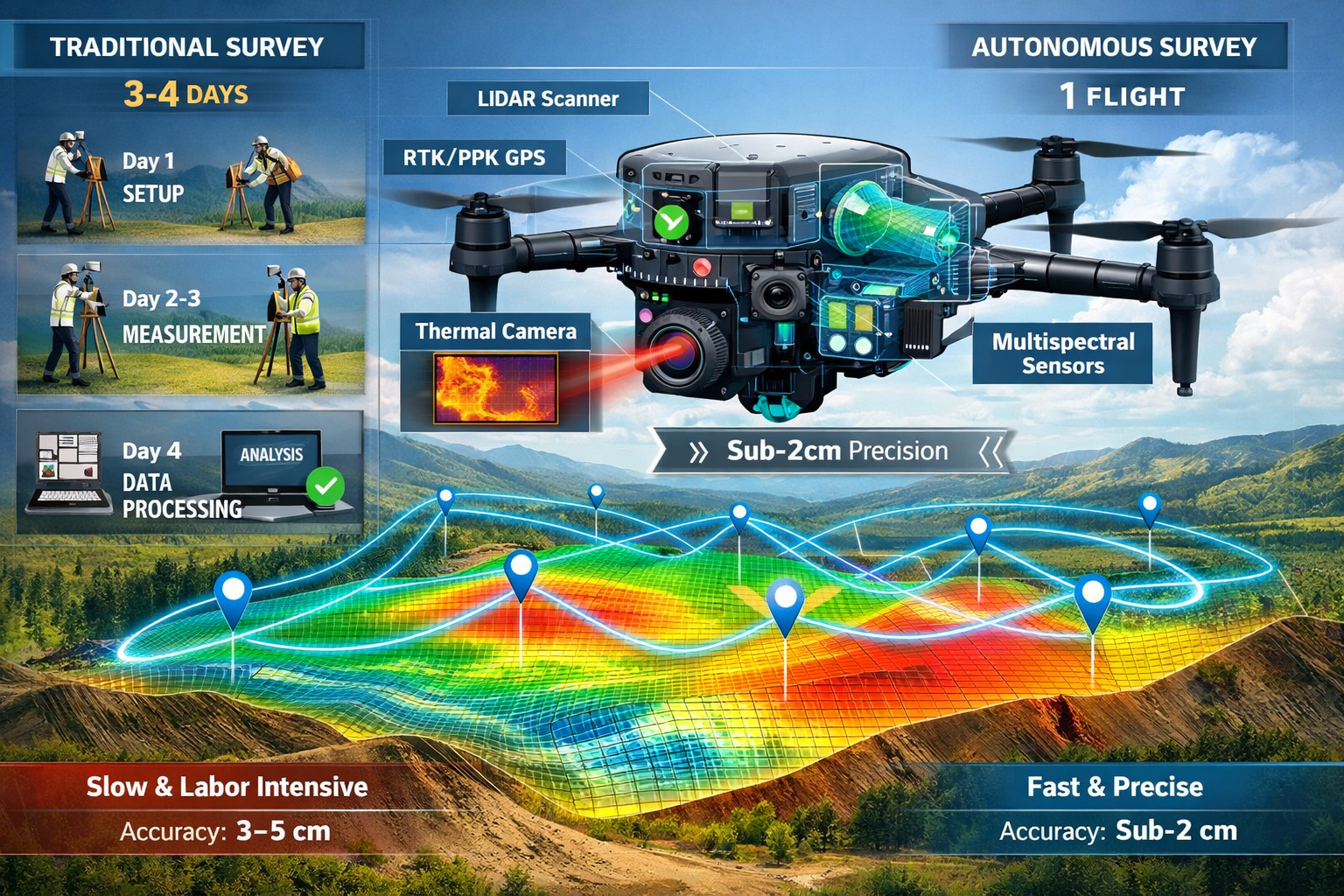
The surveying industry has entered a new era where technology is not just assisting professionals—it's fundamentally transforming how work gets done. Autonomous drone workflows powered by predictive flight paths and intelligent sensors are revolutionizing survey timelines, enabling teams to complete complex projects in single flights rather than multiple site visits. This shift represents more than incremental improvement; it's a complete reimagining of surveying efficiency and accuracy.
Modern UAV platforms equipped with RTK/PPK positioning, LiDAR, and thermal payloads now deliver centimeter-level accuracy and real-time insights that were impossible just a few years ago.[1] Projects that once demanded days of fieldwork by survey crews can now be accomplished in hours through autonomous operations. The implications for project timelines, costs, and data quality are profound—and they're reshaping expectations across construction, infrastructure, and land development sectors in 2026.
Key Takeaways
✅ Next-generation autonomous drones use predictive modeling to plan optimal flight paths and automatically adjust sensors, completing complex surveys in single flights instead of multiple site visits.
✅ Centimeter-level accuracy is now standard, with modern systems achieving sub-2cm precision through RTK/PPK positioning and advanced sensor integration.[1][2]
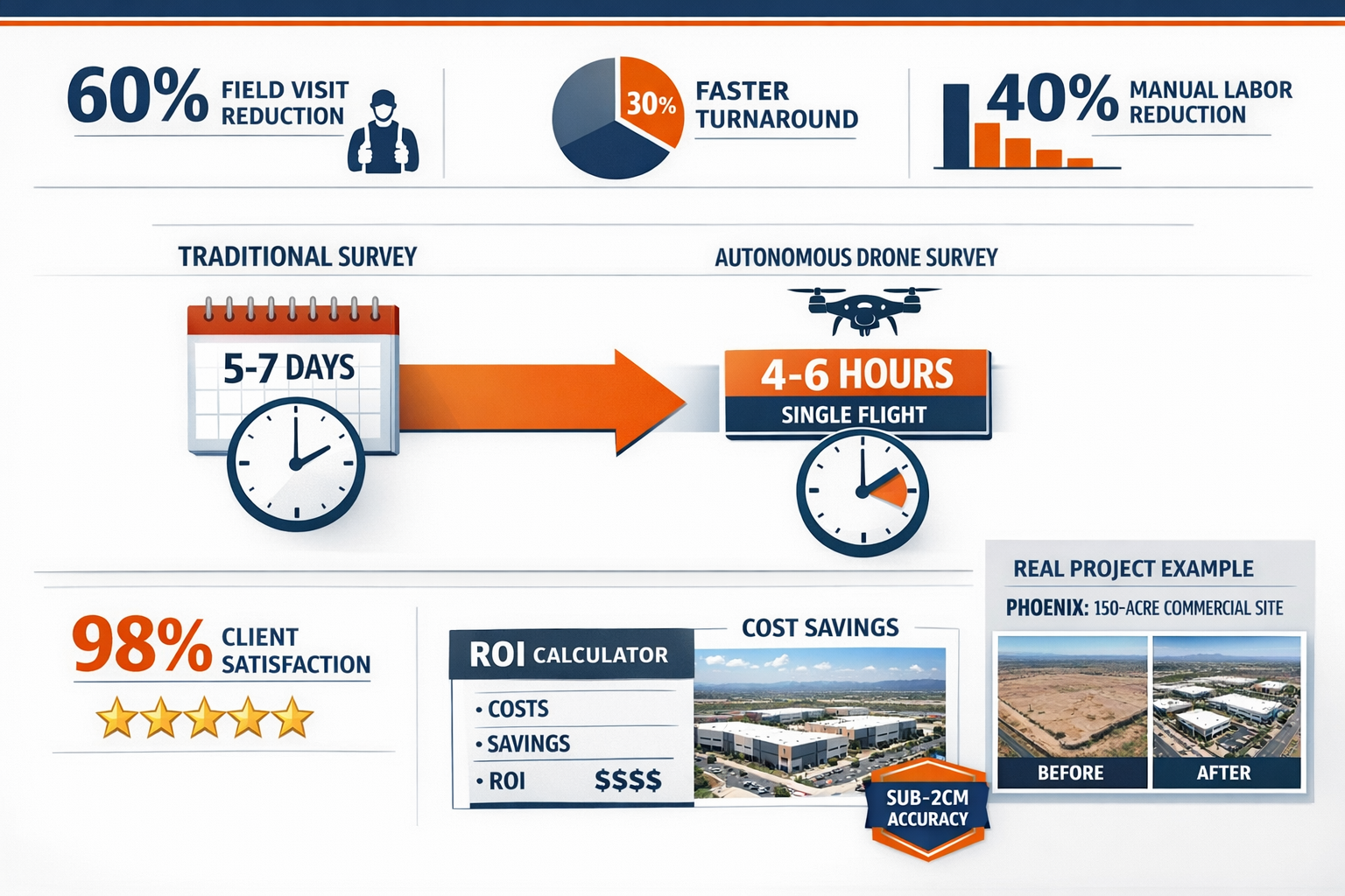
✅ Survey timelines have been slashed by 30-60%, with automated workflows reducing manual labor by 40% and field visits by 60% compared to traditional methods.[2]
✅ AI-powered analysis automatically identifies defects, vegetation encroachment, and structural issues from collected data, eliminating hours of manual review.[1]
✅ Autonomous dock systems enable fully unattended operations with scheduled missions, automatic battery swaps, and cloud uploads—no pilot intervention required.[1]
Understanding Autonomous Drone Workflows in Modern Surveying
What Makes Drone Workflows "Autonomous"
The term "autonomous" in drone surveying goes far beyond simple waypoint navigation. Today's autonomous workflows integrate multiple intelligent systems that work together without human intervention. These systems include:
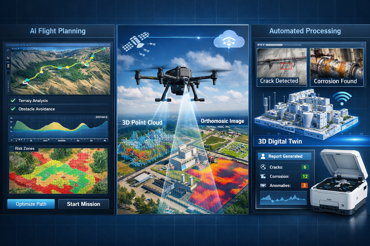
Predictive Flight Planning 🛩️
Modern platforms analyze terrain data, weather conditions, and project requirements to generate optimal flight paths before takeoff. The system calculates the most efficient route to achieve complete coverage while minimizing flight time and battery consumption.
Adaptive Sensor Management
Intelligent sensors automatically adjust settings based on lighting conditions, surface materials, and data requirements. A drone surveying a construction site might switch between RGB imaging for visual documentation, thermal sensing for moisture detection, and LiDAR for precise elevation mapping—all within a single flight.
Real-Time Obstacle Avoidance
Advanced collision detection systems use multiple sensors to identify and navigate around unexpected obstacles like construction equipment, temporary structures, or vegetation that wasn't present in pre-flight planning data.
Automated Data Processing
Once data collection is complete, autonomous workflows trigger cloud-based processing pipelines that generate deliverables like orthomosaics, point clouds, and 3D models without manual intervention.
The Technology Stack Behind Autonomous Operations
The effectiveness of autonomous drone workflows relies on several integrated technologies working in harmony:
| Technology Component | Function | Impact on Survey Timelines |
|---|---|---|
| RTK/PPK GPS | Centimeter-level positioning accuracy | Eliminates need for extensive ground control points |
| LiDAR Sensors | Penetrates vegetation to capture ground surface | Reduces need for manual clearing and multiple passes |
| Thermal Imaging | Detects moisture, heat loss, electrical issues | Identifies problems invisible to standard cameras |
| AI Processing | Automated defect detection and classification | Cuts analysis time from days to hours |
| Edge Computing | On-board data processing during flight | Enables real-time quality verification |
| Cloud Integration | Automatic upload and processing | Delivers results 24-72 hours vs. weeks[2] |
This technological convergence has created a paradigm shift in surveying capabilities. The DJI Matrice 350 RTK paired with the Zenmuse P1 sensor, for example, achieved sub-2cm accuracy on a 150-acre commercial expansion project in Phoenix in 2025.[2] This level of precision rivals traditional ground surveys while completing data collection in a fraction of the time.
For organizations looking to understand how modern surveying techniques compare to traditional approaches, our comprehensive building survey services provide detailed insights into the advantages of drone-based workflows.
How Predictive Flight Paths Transform Survey Efficiency
The Science of Predictive Path Planning
Predictive flight path technology represents one of the most significant advances in autonomous drone workflows. Unlike traditional manual flight planning, predictive systems use machine learning algorithms to analyze multiple variables and generate optimized routes.
These systems consider:
- Terrain complexity and elevation changes
- Sun angle and lighting conditions throughout the planned flight window
- Wind patterns and weather forecasts
- Battery consumption based on payload weight and environmental factors
- Data overlap requirements for photogrammetry processing
- Regulatory restrictions including no-fly zones and altitude limits
The result is a flight path that maximizes data quality while minimizing flight time. In practice, this means surveyors can achieve complete site coverage in one autonomous flight rather than multiple manual passes.
Real-World Timeline Reductions
The impact of predictive flight paths on survey timelines is measurable and substantial. Consider these documented improvements from 2024-2025 field operations:
Traditional Survey Approach:
- Site reconnaissance: 1 day
- Ground control point placement: 1-2 days
- Manual survey data collection: 2-3 days
- Data processing and analysis: 3-5 days
- Total timeline: 7-11 days
Autonomous Drone Workflow:
- Automated flight planning: 1-2 hours
- Single autonomous flight: 2-4 hours
- Automated cloud processing: 24-72 hours
- Total timeline: 2-4 days
One Phoenix engineering firm documented a 60% reduction in field visits after implementing drone mapping workflows for rapid as-built updates.[2] This wasn't just about saving time—it translated to significant cost savings and the ability to take on more projects with the same team size.
Adaptive Route Optimization During Flight
Perhaps the most impressive capability of modern autonomous systems is their ability to adjust flight paths in real-time based on data quality feedback. If the system detects insufficient image overlap in a particular area or identifies a region requiring higher resolution imaging, it can modify the flight path on the fly to address these gaps.
This adaptive behavior eliminates the frustrating scenario that plagued earlier drone surveying: discovering data gaps only after returning to the office, necessitating a return trip to the site. With predictive and adaptive flight paths, data completeness is verified during the initial flight.
Understanding how long building surveys take helps contextualize the dramatic efficiency gains that autonomous drone workflows provide for property assessments.
Intelligent Sensors: The Eyes and Ears of Autonomous Surveying
Multi-Sensor Integration for Comprehensive Data Collection
Modern autonomous drones don't just carry cameras—they're flying sensor platforms capable of capturing multiple data types simultaneously. This multi-sensor approach is fundamental to reducing survey timelines because it eliminates the need for multiple specialized flights.
RGB Imaging 📸
High-resolution cameras capture detailed visual documentation. Modern sensors like the Zenmuse P1 feature 45-megapixel full-frame sensors that capture images suitable for creating orthomosaics with ground sample distances as small as 1cm per pixel.
LiDAR Scanning 🎯
Light Detection and Ranging sensors emit laser pulses and measure return times to create precise 3D point clouds. LiDAR's ability to penetrate vegetation makes it invaluable for surveying wooded areas or overgrown sites where traditional photogrammetry would fail.
Thermal Imaging 🌡️
Thermal sensors detect temperature variations invisible to the human eye, identifying moisture intrusion, insulation gaps, electrical hotspots, and other issues critical for building inspections and surveys.
Multispectral Sensors
These specialized cameras capture data beyond the visible spectrum, useful for vegetation health analysis, material identification, and detecting subsurface features.
AI-Powered Sensor Intelligence
The "intelligent" aspect of modern sensors extends beyond hardware capabilities to include sophisticated software that interprets sensor data in real-time. Machine learning algorithms now automatically identify features and anomalies from image datasets.[1]
Automated Defect Detection
AI systems trained on thousands of examples can identify:
- Cracks in concrete and asphalt
- Corrosion on metal structures
- Vegetation encroachment on infrastructure
- Moisture damage and water staining
- Missing or damaged roof tiles
- Structural deformation
This automated analysis represents a massive time savings. What once required trained technicians spending days reviewing thousands of images can now be accomplished in hours through AI processing. The system flags potential issues for human review, allowing surveyors to focus their expertise where it's most valuable.
Adaptive Sensor Settings
Intelligent sensors automatically adjust parameters based on environmental conditions:
- Exposure compensation for varying light conditions
- Focus adjustments for different altitudes
- Gimbal stabilization responding to wind conditions
- Capture rate optimization based on flight speed and overlap requirements
The Accuracy Revolution
The combination of advanced sensors and precise positioning has delivered unprecedented accuracy levels. Modern UAV platforms equipped with RTK/PPK positioning consistently achieve centimeter-level accuracy[1], with documented field results showing sub-2cm precision on large-scale projects.[2]
This accuracy is maintained across the entire survey area, not just at individual measurement points. When creating orthomosaics or 3D models, every pixel carries positional accuracy that rivals or exceeds traditional ground survey methods.
For specialized applications like roof surveying, this level of detail enables precise measurements of roof geometry, material assessment, and damage identification—all without the safety risks of manual roof access.
Autonomous Drone Workflows: How Predictive Flight Paths and Intelligent Sensors Are Reducing Survey Timelines in Practice
Case Study: Phoenix Commercial Development
The real-world impact of autonomous drone workflows is best illustrated through documented field applications. In 2025, a 150-acre commercial expansion project in Phoenix demonstrated the transformative potential of this technology.[2]
Project Parameters:
- Site size: 150 acres
- Terrain: Mixed development with existing structures
- Requirements: Sub-2cm accuracy for construction planning
- Equipment: DJI Matrice 350 RTK with Zenmuse P1 sensor
Results:
- Data collection time: Single 4-hour autonomous flight
- Accuracy achieved: Sub-2cm throughout the site
- Deliverable turnaround: 48 hours from flight to final orthomosaic
- Traditional timeline equivalent: 7-10 days with ground survey crew
The project achieved a 30% faster data turnaround compared to traditional ground surveys, while maintaining accuracy standards required for construction staking and earthwork calculations.[2]
Workflow Automation in Scottsdale
Another compelling example from 2025 involved a Scottsdale development project that implemented fully automated workflows using DroneDeploy for flight planning and cloud processing.[2]
The automated system:
- Generated flight plans based on site boundaries and accuracy requirements
- Executed autonomous flights on scheduled intervals
- Automatically uploaded data to cloud processing
- Generated orthomosaics, elevation models, and volumetric calculations
- Delivered results to project stakeholders via web portal
Measured Impact:
- Manual labor reduction: 40% compared to traditional workflows
- Consistency: Eliminated human error in flight execution
- Scalability: Same workflow applied across multiple project sites
- Client satisfaction: Contributed to 98% satisfaction rate across drone mapping projects[2]
Enterprise-Scale Implementation
For organizations managing multiple sites simultaneously, autonomous dock systems like the DJI Dock 2 and Dock 3 represent the ultimate expression of workflow automation.[1] These systems perform scheduled missions with automatic battery swaps and cloud uploads, enabling fully autonomous operations without pilot intervention.
A construction management firm operating across multiple sites implemented dock-based autonomous surveying with these results:
Before Autonomous Workflows:
- Survey frequency: Monthly site visits
- Personnel required: 2-person crew per site
- Data latency: 5-7 days from visit to deliverables
- Coverage: Limited to critical areas due to time constraints
After Autonomous Workflows:
- Survey frequency: Weekly automated flights
- Personnel required: Zero on-site (remote monitoring only)
- Data latency: 24-48 hours from flight to deliverables
- Coverage: Complete site documentation every flight
This transformation enabled the firm to provide clients with digital twins updated through recurring flights, enabling trend analysis and proactive repairs rather than reactive intervention.[1] Project managers could identify issues like erosion, unauthorized access, or construction delays within days rather than weeks.
For organizations conducting Level 3 building surveys or other comprehensive assessments, the ability to capture complete site documentation in single flights dramatically improves project efficiency.
The Business Impact of Reduced Survey Timelines
Cost Savings and ROI
The timeline reductions enabled by autonomous drone workflows translate directly to cost savings across multiple dimensions:
Direct Labor Cost Reduction 💰
Reducing a 7-day survey project to a 2-day autonomous workflow eliminates 5 days of labor costs. For a two-person survey crew, this represents significant savings per project. The 40% manual labor reduction documented in automated workflows[2] compounds these savings across multiple projects.
Equipment Utilization Efficiency
Faster project completion means survey equipment spends less time on each project, allowing the same equipment to serve more clients. This improved utilization increases revenue potential without additional capital investment.
Reduced Field Visit Costs
The 60% reduction in field visits[2] eliminates travel time, vehicle costs, and the logistical overhead of coordinating site access. For firms serving large geographic areas, these savings are substantial.
Faster Revenue Recognition
Completing projects in days rather than weeks accelerates billing cycles and improves cash flow. The 24-72 hour deliverable turnaround[2] means clients receive results faster, improving satisfaction and enabling quicker project progression.
Competitive Advantages
Organizations implementing autonomous drone workflows gain several competitive advantages:
Capacity Expansion Without Headcount Growth
By completing surveys 30-60% faster, firms can take on more projects with existing staff. This scalability enables growth without proportional increases in labor costs.
Service Differentiation
Offering faster turnaround times and more comprehensive data (through multi-sensor collection) differentiates services in competitive markets. The 98% client satisfaction rate[2] achieved through drone mapping workflows demonstrates the value clients place on these capabilities.
Access to New Project Types
Some projects simply weren't feasible with traditional survey methods due to time or cost constraints. Autonomous workflows make previously uneconomical projects viable, opening new market opportunities.
Risk Reduction
Autonomous operations reduce personnel exposure to hazardous environments like busy roadways, unstable structures, or extreme weather conditions. This safety improvement reduces insurance costs and liability exposure.
Client Experience Transformation
The impact on client experience extends beyond faster delivery:
More Frequent Updates
Automated recurring flights enable weekly or even daily progress monitoring on active construction sites, providing project stakeholders with unprecedented visibility into project status.
Richer Data Products
Multi-sensor collection delivers comprehensive datasets that answer questions clients didn't even know to ask. Thermal imaging might reveal drainage issues, LiDAR might identify grading problems, and AI analysis might flag safety concerns—all from a single flight.
Interactive Deliverables
Cloud-based platforms provide clients with interactive 3D models, measurement tools, and time-series comparisons rather than static PDF reports. This accessibility improves decision-making and stakeholder communication.
For firms providing measured building surveys, autonomous drone workflows complement traditional techniques by providing comprehensive exterior documentation that integrates with interior measurements.
Implementation Strategies for Autonomous Drone Workflows
Choosing the Right Platform
Implementing autonomous drone workflows requires careful platform selection based on project requirements and operational needs:
Entry-Level Automation
Organizations new to drone surveying can start with platforms offering semi-autonomous features:
- Pre-programmed flight paths with manual takeoff/landing
- Automated image capture at waypoints
- Cloud processing integration
- Investment range: $5,000-$15,000 for drone and basic software
Mid-Tier Autonomous Systems
Established operations benefit from platforms with advanced autonomous capabilities:
- Fully automated flight execution
- Real-time obstacle avoidance
- Multi-sensor integration
- RTK/PPK positioning for centimeter accuracy
- Investment range: $20,000-$50,000 for complete system
Enterprise Autonomous Solutions
Organizations managing multiple sites or requiring 24/7 capabilities should consider:
- Autonomous dock systems (DJI Dock 2/3)
- Fleet management platforms
- Automated mission scheduling
- Remote monitoring and control
- Investment range: $50,000-$150,000+ per installation
Software Ecosystem Selection
The software platform is as critical as the hardware for achieving workflow automation. Enterprise compliance platforms like AirData UAV, DroneDeploy, SkyeBrowse, and FlytBase enable centralized fleet management, cloud-based data syncing, and automated mission planning for multi-site operations.[1]
Key Software Capabilities:
- Flight planning automation with terrain-aware path generation
- Cloud processing pipelines for automated deliverable creation
- AI-powered analysis for defect detection and feature extraction
- API integration with existing project management systems
- Multi-user collaboration with role-based access control
- Compliance documentation for regulatory requirements
Training and Workflow Integration
Successful implementation requires more than technology acquisition—it demands workflow redesign and team training:
Pilot Certification and Training
Even with autonomous systems, certified pilots provide oversight and handle exceptions. Invest in comprehensive training covering:
- Regulatory compliance and airspace authorization
- Platform-specific operation and maintenance
- Emergency procedures and manual override
- Data quality verification
Process Documentation
Document standardized workflows for:
- Pre-flight planning and safety checks
- Autonomous mission execution and monitoring
- Data quality verification procedures
- Deliverable creation and client communication
- Equipment maintenance and calibration
Integration with Existing Services
Autonomous drone workflows should complement rather than replace existing capabilities. For example, drone surveys provide excellent exterior documentation for building surveys, while traditional methods remain essential for interior assessments and specialized testing.
Overcoming Challenges and Limitations
Regulatory Considerations
Autonomous drone operations must comply with evolving aviation regulations:
Current Regulatory Environment (2026)
Most jurisdictions require:
- Certified remote pilots for autonomous operations
- Visual line of sight maintenance (though waivers available)
- Airspace authorization for controlled areas
- Operations below specific altitude limits
- Respect for privacy and property rights
Beyond Visual Line of Sight (BVLOS)
True autonomous operations often require BVLOS waivers, which remain challenging to obtain in many jurisdictions. Organizations should:
- Engage with regulatory authorities early in planning
- Document safety protocols and risk mitigation measures
- Consider observer networks for extended operations
- Stay current with regulatory developments
Weather and Environmental Limitations
Autonomous systems have operational limits:
Weather Constraints ⛈️
- Wind speed limits (typically 25-35 mph depending on platform)
- Precipitation restrictions (most platforms not waterproof)
- Temperature extremes affecting battery performance
- Visibility requirements for optical sensors
Environmental Challenges
- Magnetic interference near power lines or metal structures
- GPS signal loss in urban canyons or under dense canopy
- Reflective surfaces causing sensor confusion
- Dynamic obstacles (vehicles, people, wildlife)
Smart implementation includes contingency planning for weather delays and alternative methods for challenging environments.
Data Management and Processing
The efficiency of autonomous data collection can create downstream bottlenecks:
Data Volume Challenges
A single autonomous flight might generate:
- 500-2,000 high-resolution images
- Gigabytes of LiDAR point cloud data
- Thermal and multispectral datasets
- Total data volume: 50-200GB per flight
Processing Requirements
Organizations need:
- High-performance computing for local processing, or
- Cloud processing subscriptions with adequate bandwidth
- Storage infrastructure for raw data and deliverables
- Backup and disaster recovery systems
Quality Control Procedures
Automated workflows still require human oversight:
- Data completeness verification
- Accuracy validation against control points
- Anomaly investigation and correction
- Deliverable review before client delivery
Future Developments in Autonomous Surveying
AI and Machine Learning Advances
The next generation of autonomous drone workflows will feature even more sophisticated AI capabilities:
Predictive Maintenance 🔧
AI systems will analyze historical data to predict when infrastructure will require maintenance, enabling proactive intervention before failures occur. Digital twins updated through recurring autonomous flights will track deterioration rates and forecast maintenance needs.
Automated Feature Extraction
Advanced computer vision will automatically identify and classify features:
- Building footprints and dimensions
- Vegetation types and health status
- Infrastructure components (poles, signs, fixtures)
- Change detection between survey periods
Natural Language Interfaces
Future systems may accept survey requirements in plain language: "Survey the construction site weekly and alert me to any safety hazards or schedule delays." The AI would plan flights, execute missions, analyze data, and generate alerts without detailed manual configuration.
Swarm Technology
Multiple drones operating in coordinated swarms will dramatically reduce survey times for large areas:
Coordinated Multi-Drone Operations
- Simultaneous coverage of different site sections
- Specialized sensor distribution across swarm members
- Reduced flight time through parallel operations
- Redundancy and reliability improvements
Dynamic Task Allocation
Swarm intelligence will enable drones to dynamically redistribute tasks based on battery levels, sensor availability, and changing conditions.
Integration with Other Technologies
Autonomous drone workflows will increasingly integrate with complementary technologies:
IoT Sensor Networks
Ground-based sensors will provide continuous monitoring between drone flights, with autonomous missions triggered by sensor alerts indicating changes requiring investigation.
5G Connectivity
High-bandwidth, low-latency 5G networks will enable:
- Real-time video streaming from autonomous flights
- Cloud-based flight control and processing
- Immediate data delivery to stakeholders
- Remote expert consultation during missions
Augmented Reality Visualization
AR interfaces will overlay drone-collected data onto real-world views, enabling field personnel to visualize subsurface utilities, planned construction, or historical conditions while on-site.
Measuring Success: KPIs for Autonomous Workflows
Operational Metrics
Organizations implementing autonomous drone workflows should track these key performance indicators:
Timeline Metrics ⏱️
- Average project completion time (data collection to deliverable)
- Reduction in field visit frequency
- Data processing turnaround time
- Client deliverable delivery speed
Quality Metrics
- Positional accuracy achieved (compared to requirements)
- Data completeness percentage
- Rework/re-flight frequency
- Client satisfaction scores
Efficiency Metrics
- Labor hours per project
- Cost per acre surveyed
- Equipment utilization rate
- Revenue per employee
Safety Metrics
- Incident-free flight hours
- Personnel exposure to hazardous conditions
- Regulatory compliance rate
- Near-miss reporting and resolution
Return on Investment Calculation
Calculate ROI by comparing:
Investment Costs:
- Hardware acquisition (drone, sensors, accessories)
- Software subscriptions (flight planning, processing, management)
- Training and certification
- Insurance and regulatory compliance
Returns:
- Labor cost savings per project
- Increased project capacity (revenue potential)
- Reduced equipment and travel costs
- Competitive advantage and market differentiation
- Risk reduction and insurance savings
Most organizations implementing autonomous drone workflows report ROI achievement within 12-24 months, with ongoing returns accelerating as workflows mature and efficiency improves.
Conclusion: The Future of Surveying Is Autonomous
Autonomous drone workflows powered by predictive flight paths and intelligent sensors have fundamentally transformed surveying timelines in 2026. What once required survey crews working multiple days can now be accomplished in single autonomous flights delivering centimeter-level accuracy and comprehensive multi-sensor data.[1][2]
The evidence is compelling: 60% reductions in field visits, 30% faster data turnaround, 40% manual labor savings, and 98% client satisfaction rates.[2] These aren't aspirational goals—they're documented results from field operations across diverse project types.
The technology has matured beyond early adoption to become a competitive necessity. Organizations that haven't implemented autonomous workflows face increasing disadvantages in project timelines, cost competitiveness, and service capabilities compared to those leveraging these advanced systems.
Actionable Next Steps
For organizations ready to implement or expand autonomous drone workflows:
-
Assess Current Capabilities 📋
Evaluate existing survey workflows to identify bottlenecks and opportunities where autonomous systems would deliver the greatest impact. -
Define Requirements
Specify accuracy needs, coverage areas, sensor requirements, and deliverable formats for typical projects to guide platform selection. -
Start with Pilot Projects
Implement autonomous workflows on a limited scale to validate technology, refine processes, and build team expertise before full-scale deployment. -
Invest in Training
Ensure team members receive comprehensive training on both technology operation and workflow integration to maximize return on investment. -
Establish Quality Protocols
Develop verification procedures to ensure autonomous workflows maintain accuracy and completeness standards. -
Monitor and Optimize
Track performance metrics, gather client feedback, and continuously refine workflows to improve efficiency and quality. -
Stay Current
Technology evolution continues rapidly—maintain awareness of new capabilities, regulatory changes, and best practices through industry engagement.
The surveying industry's transformation through autonomous drone workflows represents more than technological advancement—it's a fundamental reimagining of how surveying services are delivered. Organizations that embrace this transformation position themselves for sustained competitive advantage in an increasingly efficiency-driven market.
For professional surveying services that leverage cutting-edge autonomous drone technology alongside traditional expertise, explore our comprehensive surveying capabilities and discover how modern workflows can transform your project timelines.
References
[1] How Drones Are Transforming Surveying And Inspection Workflows – https://www.dslrpros.com/blogs/drone-trends/how-drones-are-transforming-surveying-and-inspection-workflows
[2] Drone Mapping – https://www.extremeaerialproductions.com/post/drone-mapping
[3] Revolutionizing Land Surveying The Rise Of Drone Technology And Uav Applications In 2026 – https://nottinghillsurveyors.com/blog/revolutionizing-land-surveying-the-rise-of-drone-technology-and-uav-applications-in-2026
[4] Webinar The State Of Drone Surveying A Strategic Briefing For 2026 – https://www.aerotas.com/blog/webinar-the-state-of-drone-surveying-a-strategic-briefing-for-2026