The property surveyor arrives at a Victorian terrace in South London, but instead of just a clipboard and moisture meter, they're carrying a tablet, a handheld laser scanner, and a compact drone. Within hours, the homebuyer receives a 3D interactive model of the property showing not just structural defects, but also thermal imaging overlays revealing exactly where £2,000 annually escapes through poor insulation. This is Building Surveying in 2026: Digital Tools, Energy Retrofits, and Enhanced Risk Assessments – a transformation that's making property surveys more accurate, comprehensive, and valuable than ever before.
The surveying profession has undergone a remarkable digital revolution. Traditional methods that once took days now take hours, and buyers receive insights that extend far beyond simple defect lists. Modern surveys combine laser-precise measurements, drone-captured roof imagery, and AI-powered analysis to deliver unprecedented clarity about a property's condition and long-term costs. For homebuyers navigating the UK's aging housing stock, these advances mean better-informed decisions and clearer understanding of renovation investments.
Key Takeaways
- 🚁 Drone and 3D scanning technology now delivers property surveys 10 to 50 times faster than traditional methods, with detailed visualizations replacing static photographs
- 💡 Energy retrofit assessments are becoming standard survey components, providing homebuyers with specific cost projections for improving thermal efficiency and reducing bills
- 🤖 AI-powered analysis reduces data processing time dramatically while identifying structural patterns and risks that human surveyors might miss
- 📊 Enhanced risk assessments now incorporate real-time data integration, predictive modeling, and comprehensive cost projections for defect remediation
- 🔗 Integrated digital workflows connect survey data directly to Building Information Models (BIM), enabling seamless collaboration between surveyors, architects, and contractors
The Digital Revolution Transforming Building Surveys
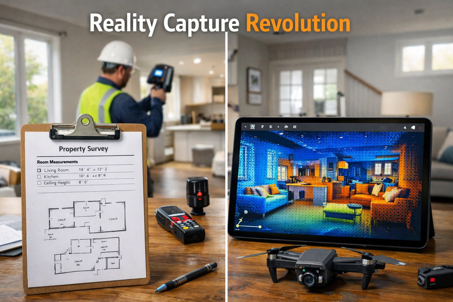
Reality Capture Goes Mainstream
Reality capture technology has evolved from specialized equipment requiring expert operators to accessible tools that surveying firms of all sizes now deploy routinely. According to industry experts at Trimble, this democratization has expanded dramatically in 2026 due to user-friendly interfaces and broader platform support.[2] What once required expensive consultants and weeks of processing now happens in-house within days.
Modern building surveyors utilize several reality capture technologies:
- LiDAR (Light Detection and Ranging) scanning creates millions of precise measurement points per second
- 3D laser scanning generates detailed interior and exterior models with millimeter accuracy
- Photogrammetry converts standard photographs into measurable 3D representations
- Mobile mapping systems allow surveyors to walk through properties capturing comprehensive data
The practical impact for homebuyers is transformative. When commissioning a Level 3 full building survey, clients now receive interactive 3D models they can explore from their computers or phones. Instead of reading descriptions like "crack observed in southeast bedroom wall," buyers can virtually walk through the property, zoom into the exact crack location, and see precise measurements overlaid on photorealistic imagery.
Drone Technology Acceleration
Unmanned aerial vehicles (UAVs) have become significantly cheaper and more accessible, with usage skyrocketing across surveying applications.[3] The impact on building surveys is particularly dramatic for roof inspections – traditionally one of the most challenging and dangerous aspects of property assessment.
Key advantages of drone-enabled surveys:
| Traditional Method | Drone-Enhanced Method |
|---|---|
| Ladder access required (safety risk) | No physical roof access needed |
| Limited photographic angles | 360-degree comprehensive coverage |
| Weather-dependent scheduling | Rapid deployment in suitable conditions |
| Inspector's visual assessment only | High-resolution imagery with zoom capability |
| Difficult to document inaccessible areas | Complete coverage including valleys and hidden sections |
EarthStar Geomatics reports producing topographic surveys and volume measurements 10 to 50 times faster than traditional methods using drones combined with AI processing.[1] For residential surveys, this speed translates to reduced costs and faster turnaround times – critical factors when building survey timeframes can impact property transactions.
Drone imagery also provides lasting value. Homebuyers receive permanent high-resolution documentation of their property's condition at purchase, creating invaluable baseline records for insurance claims, future maintenance planning, and renovation projects.
Mobile 3D Mapping Capabilities
Surveyors can now create detailed 3D models from indoor and outdoor environments without bulky equipment, delivering results in hours rather than traditional multi-day waiting periods.[3] Handheld scanning devices like the Matterport Pro2 or Leica BLK2GO enable single operators to capture entire properties during standard survey appointments.
This technology proves particularly valuable for:
- Period properties with complex architectural features requiring precise documentation
- Properties with suspected structural movement where accurate dimensional analysis is critical
- Pre-renovation surveys where architects and contractors need exact measurements
- Dispute resolution providing indisputable dimensional evidence
The consequences of failing to act on survey findings become clearer when buyers can visualize problems in three dimensions rather than interpreting written descriptions. A subsiding bay window isn't just mentioned in a report – it's visible as a measurable deviation from vertical in the 3D model.
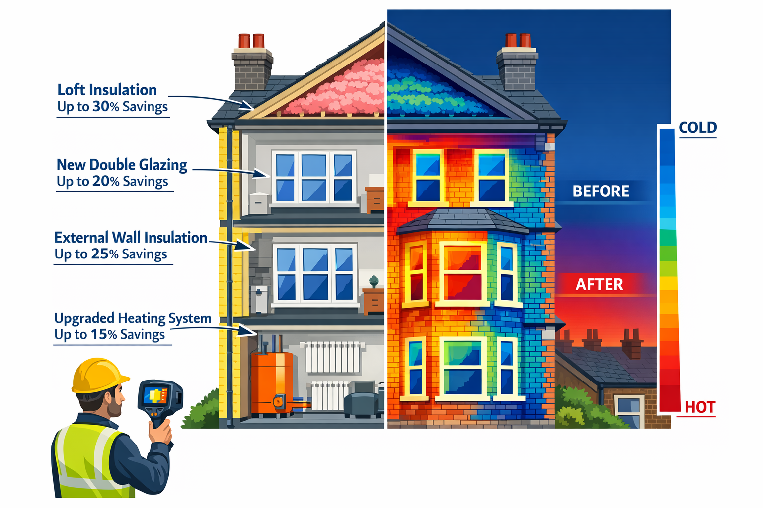
Energy Retrofits: The New Survey Priority in 2026
Why Energy Assessment Matters Now
The UK's commitment to net-zero carbon emissions by 2050 has fundamentally changed what homebuyers need to know about properties. With energy costs remaining volatile and Energy Performance Certificate (EPC) requirements tightening, understanding a property's thermal efficiency has become as important as knowing about its structural condition.
Building Surveying in 2026: Digital Tools, Energy Retrofits, and Enhanced Risk Assessments now routinely incorporate thermal imaging surveys and energy retrofit recommendations. This shift reflects both regulatory pressure and buyer demand – purchasers want to know not just what's wrong with a property, but what it will cost to make it energy-efficient.
Thermal Imaging Integration
Modern building surveys increasingly include thermal imaging cameras that reveal heat loss invisible to the naked eye. These infrared cameras detect temperature variations across building surfaces, identifying:
- 🌡️ Missing or inadequate insulation in walls, roofs, and floors
- 💨 Air leakage points around windows, doors, and service penetrations
- 💧 Hidden moisture problems that appear as cold spots
- 🔥 Heating system inefficiencies and distribution issues
The visual impact of thermal imaging is powerful. A homebuyer might read "loft insulation appears thin" with limited concern, but seeing their potential new home glowing bright red on a thermal image – literally broadcasting expensive heat into the atmosphere – creates immediate understanding of the financial implications.
Surveyors now quantify these findings with projected costs. A typical thermal survey report in 2026 might state: "Thermal imaging reveals significant heat loss through single-glazed sash windows (estimated 25% of total heat loss). Replacement with heritage-style double glazing: £12,000-£15,000. Projected annual savings: £850. Payback period: 15 years."
Retrofit Roadmaps
Progressive surveying firms now provide energy retrofit roadmaps as standard components of comprehensive building surveys. These prioritized action plans guide homebuyers through cost-effective improvement sequences, avoiding the common mistake of implementing measures in the wrong order.
Typical retrofit priority sequence:
- Draft proofing and air sealing (lowest cost, immediate impact)
- Loft insulation upgrade (high impact, moderate cost)
- Wall insulation (external or internal depending on property type)
- Window and door upgrades (significant cost, long-term benefit)
- Heating system modernization (heat pumps, smart controls)
- Renewable energy integration (solar PV, battery storage)
This sequenced approach prevents costly errors. For example, installing a new heating system before improving insulation means oversizing the system for post-retrofit needs, wasting money on unnecessary capacity.
When examining environmental issues during surveys, modern surveyors consider both immediate concerns (like asbestos or contamination) and long-term environmental performance, providing holistic property assessments.
Cost-Benefit Analysis Tools
Advanced surveying practices in 2026 utilize AI-powered cost modeling tools that analyze property characteristics against extensive databases of retrofit projects. These systems provide homebuyers with:
- Accurate cost estimates based on property size, type, and location
- Energy savings projections using local climate data and energy prices
- Payback period calculations for each improvement measure
- Property value uplift estimates from energy efficiency improvements
- Available grant and financing options specific to the property location
For a typical Victorian terrace requiring comprehensive retrofitting, buyers receive clear financial scenarios: "Total retrofit cost: £35,000. Annual energy savings: £2,400. Government grant eligibility: £10,000. Net investment: £25,000. Payback period: 10.4 years. Property value increase: 8-12%."
This financial clarity helps buyers make informed decisions about whether to proceed with purchase, negotiate price reductions, or budget for post-purchase improvements. Understanding how long a building survey takes becomes less important than understanding what actionable information it provides.
Enhanced Risk Assessments Through Digital Integration
AI-Powered Defect Analysis
Artificial intelligence has become a game-changing technology in building surveying, with experts citing AI as a top technology priority alongside scanning, data sharing, and analytics.[6] Machine learning algorithms now assist surveyors in identifying patterns, assessing severity, and predicting future deterioration.
How AI enhances risk assessment:
- Pattern recognition identifies defect types from thousands of reference images
- Severity classification compares findings against extensive defect databases
- Predictive modeling forecasts how defects will progress over time
- Cost estimation draws on historical repair data for accurate projections
- Priority ranking helps buyers understand which issues need immediate attention
AI increases efficiency by reducing analysis time for gathered data and can monitor structural and terrain changes over time for environmental studies or construction monitoring.[3] For building surveys, this means surveyors spend less time on routine analysis and more time applying professional judgment to complex situations.
Consider subsidence assessment – traditionally a highly subjective area requiring extensive experience. Modern AI systems analyze crack patterns, local geology, vegetation proximity, drainage conditions, and historical movement data to provide probabilistic risk assessments: "Based on crack pattern analysis and local clay soil conditions, probability of ongoing subsidence: 65%. Recommended monitoring period: 12 months. Estimated stabilization cost if active: £15,000-£25,000."
Real-Time Data Integration
Building Surveying in 2026: Digital Tools, Energy Retrofits, and Enhanced Risk Assessments benefits enormously from real-time data integration with external databases and monitoring systems. Surveyors now access:
- Local authority planning records showing nearby development that might affect the property
- Historical flood data with climate-adjusted future risk modeling
- Ground movement databases tracking subsidence patterns across regions
- Environmental hazard registers identifying contamination, radon, or other risks
- Building regulation compliance records for previous alterations
This connectivity transforms risk assessment from isolated property inspection to contextualized analysis considering broader environmental and regulatory factors. A surveyor examining a property near a river doesn't just note current flood defenses – they access Environment Agency data showing how flood risk zones are projected to change over the next 30 years under various climate scenarios.
Integration with statutory considerations databases ensures surveyors flag potential compliance issues with building regulations, planning permissions, and conservation area restrictions that could affect future alterations.
Common Data Environments (CDEs)
Common Data Environments are becoming fundamental delivery platforms where surveyors contribute to dynamic, shared environments enabling real-time decision-making rather than producing isolated static plans or point clouds.[2] This represents a fundamental shift in how survey information is delivered and utilized.
Traditional survey delivery: PDF report emailed to client, who forwards to solicitor, mortgage lender, and contractor. Each party reads different sections, asks questions via email, creating fragmented communication chains.
CDE-based survey delivery: Survey data uploaded to secure cloud platform where client, solicitor, lender, and contractors access the same information simultaneously. Questions are answered once, visible to all parties. Updates and additional information are added to the same environment, creating a comprehensive property record.
Benefits of CDE-based surveying include:
✅ Reduced miscommunication – everyone works from identical information
✅ Faster decision-making – stakeholders access data immediately
✅ Better collaboration – contractors can measure directly from 3D models
✅ Permanent records – comprehensive property documentation for future reference
✅ Version control – no confusion about which report version is current
For buyers commissioning a RICS building survey, CDE delivery means their survey becomes a living document that contractors, architects, and specialists can reference and annotate throughout renovation projects.
Integrated Workflow Connectivity
Modern surveying practices embrace end-to-end digital workflows where data flows seamlessly between platforms. Drone maps feed directly into BIM models, which connect to scheduling software, with schedules updating field management apps and field reports syncing with project management dashboards.[1]
This integration eliminates traditional friction points:
- No manual data re-entry between survey and design software
- Automatic measurement extraction for quantity surveying
- Direct export to contractor estimating systems
- Seamless handoff between survey, design, and construction phases
For homebuyers, this connectivity means survey findings translate directly into actionable renovation plans. A surveyor identifies roof tiles requiring replacement, and the 3D model automatically calculates the exact area, generates a material list, and provides contractors with precise measurements for quotations – all without manual interpretation or measurement.
Visualization-Driven Collaboration
From 2D Plans to 3D Experiences
Design conversations increasingly occur within 3D models rather than traditional 2D plans, with "spatial data becoming the foundation for collaboration" according to Sandra Winstead, senior director at Trimble.[2] This shift fundamentally changes how homebuyers understand and interact with survey findings.
Traditional survey reports rely heavily on written descriptions supplemented by photographs. Buyers must mentally construct three-dimensional understanding from two-dimensional information – a challenging task requiring spatial reasoning skills many people lack.
Modern 3D survey models eliminate this cognitive burden. Buyers virtually walk through properties, understanding exactly where problems exist in relation to rooms they recognize. A structural crack isn't just "in the rear elevation" – it's visible in the virtual dining room, precisely where it appears in reality.
This visualization capability proves invaluable when considering what's in a Level 3 survey and how to communicate findings to family members, contractors, or mortgage lenders who haven't visited the property.
Enhanced Client Communication
The democratization of technology enables more comprehensive data collection and accuracy for faster decision-making, with reality capture technology now within reach of firms of all sizes.[6] This accessibility means even smaller surveying practices can deliver visualization-rich reports that were previously available only from large firms with specialized equipment.
Communication improvements include:
- Annotated 3D models with clickable defect markers linked to detailed descriptions
- Video walkthroughs narrated by the surveyor explaining key findings
- Interactive comparison tools showing before/after renovation scenarios
- Virtual reality experiences for fully immersive property exploration
- Augmented reality apps overlaying defect information on live property views
These tools address a persistent challenge in building surveying: ensuring clients genuinely understand findings rather than simply receiving information. A buyer might skim past "moderate timber decay to roof timbers" in a written report, but watching a video of the surveyor pointing to affected timbers while explaining replacement costs creates lasting comprehension.
The impact on purchase decisions is significant. Better understanding leads to more confident negotiations, realistic renovation budgets, and fewer post-purchase surprises. Buyers who truly grasp the implications of survey findings are less likely to experience the shock of discovering the average price reduction after survey doesn't cover actual repair costs.
The Expanding Role of Building Surveyors
From Vendors to Partners
Surveyors are transitioning from "vendors of measurement services" to collaborative partners embedded in project teams from conception through long-term asset management.[2] This evolution reflects the profession's increasing value in an era where property decisions require multidisciplinary expertise.
Modern building surveyors often coordinate input from:
- Structural engineers assessing load-bearing capacity and stability
- Energy assessors calculating thermal performance and retrofit options
- Environmental consultants evaluating contamination and sustainability
- Conservation specialists advising on heritage property considerations
- Quantity surveyors providing detailed cost projections
This coordinated approach delivers comprehensive assessments that single-discipline surveys cannot match. A Victorian property survey might combine traditional structural assessment, thermal imaging, heritage impact analysis, and detailed cost modeling – all synthesized into coherent recommendations.
For homebuyers, this means receiving strategic property advice rather than just defect lists. Surveyors answer questions like "Should I buy this property given these issues?" and "What's the optimal improvement sequence?" rather than simply documenting what they observe.
Long-Term Asset Management Support
Forward-thinking surveying firms now offer ongoing asset management services extending beyond initial purchase surveys. These services include:
- Periodic condition monitoring using drone surveys and remote sensing
- Maintenance planning with predictive scheduling based on component lifecycles
- Energy performance tracking monitoring actual consumption against projections
- Renovation project management overseeing contractor work quality
- Property record maintenance updating building information as changes occur
This long-term relationship model benefits both surveyors and property owners. Surveyors develop deep property knowledge enabling more accurate advice, while owners receive consistent expertise throughout their ownership period.
Cloud computing integration supports these ongoing relationships, with cloud platforms offering reduced maintenance, automated scans, and improved collaboration between surveyors and clients.[3] Property owners access their building information through secure portals, reviewing historical surveys, maintenance records, and updated assessments as their properties evolve.
Geographic Information Systems (GIS) Integration
GIS has become vital for organizing geospatial data, enabling enhanced analysis to identify patterns in land use and helping surveyors make better decisions through easy-to-understand visuals.[3] Building surveyors increasingly utilize GIS platforms to contextualize individual properties within broader geographic patterns.
GIS integration enables analysis of:
- Flood risk zones with historical incident mapping and future projections
- Subsidence susceptibility based on soil types and geological conditions
- Planning constraints including conservation areas and protected views
- Infrastructure development showing planned transport and utility projects
- Environmental factors such as air quality, noise levels, and green space access
For a property in a clay soil area, GIS analysis might reveal that 40% of properties within 500 meters have experienced subsidence claims in the past decade – information that dramatically affects risk assessment and insurance considerations.
This geographic context helps buyers understand not just the property itself, but its location-specific risks and opportunities. A home might be structurally sound, but GIS analysis revealing it sits within a future flood risk zone under climate change projections fundamentally affects long-term value and insurability.
Practical Implications for Homebuyers in 2026

What to Expect from Modern Building Surveys
Homebuyers commissioning surveys in 2026 should expect significantly more comprehensive deliverables than previous generations received. A typical advanced building survey now includes:
📋 Core deliverables:
- Detailed written report with defect descriptions and severity ratings
- Interactive 3D model with annotated defect locations
- High-resolution drone photography of all elevations and roof areas
- Thermal imaging analysis with heat loss quantification
- Energy retrofit roadmap with prioritized improvements
- Cost projections for all identified repairs and upgrades
- Risk assessment with probabilistic severity ratings
🔧 Optional enhancements:
- Specialist structural engineering assessments
- Detailed timber and damp surveys with invasive investigation
- Asbestos surveys for pre-2000 properties
- Environmental contamination screening
- Heritage impact assessments for listed buildings
The cost of measured building surveys reflects this expanded scope, but the value proposition has improved dramatically. Buyers receive actionable intelligence supporting confident decisions rather than basic defect lists requiring extensive interpretation.
Questions to Ask Your Surveyor
To ensure you receive a Building Surveying in 2026: Digital Tools, Energy Retrofits, and Enhanced Risk Assessments that meets modern standards, ask prospective surveyors:
- What digital tools do you use? (Look for drone, 3D scanning, thermal imaging capabilities)
- Will I receive a 3D model of the property? (Essential for comprehensive understanding)
- Do you provide energy retrofit assessments? (Critical for long-term cost planning)
- How do you deliver survey findings? (Cloud-based CDE access is optimal)
- What AI or analytical tools support your assessments? (Indicates modern methodology)
- Can you provide cost projections for identified issues? (Essential for budgeting)
- Do you offer post-survey support for contractor selection? (Valuable for renovation planning)
Surveyors who cannot articulate their digital capabilities or still rely primarily on written reports and static photographs may not be utilizing current best practices.
Maximizing Survey Value
To extract maximum value from modern building surveys:
✅ Commission surveys early in the purchase process, allowing time for detailed review and follow-up questions
✅ Share 3D models with contractors for accurate quotations before purchase completion
✅ Use thermal imaging findings to negotiate price reductions reflecting energy upgrade costs
✅ Request CDE access for all stakeholders to ensure coordinated decision-making
✅ Maintain survey data as permanent property records for future reference
✅ Implement retrofit recommendations in the suggested sequence for optimal cost-effectiveness
✅ Consider ongoing monitoring services for properties with identified risks requiring observation
The investment in a comprehensive survey typically represents less than 0.5% of property value but can identify issues worth tens of thousands of pounds. Understanding 5 things every homeowner should know about their property starts with a thorough initial assessment using modern surveying technology.
Future Developments on the Horizon
Emerging Technologies
While 2026 represents a significant advancement in building surveying capabilities, several emerging technologies promise further transformation:
🔬 Advanced materials analysis: Portable spectrometry devices will enable on-site identification of building materials, detecting harmful substances and assessing material quality without laboratory testing.
🤖 Autonomous survey drones: Fully autonomous UAVs will conduct routine surveys without operator intervention, using AI to identify defects and anomalies requiring human expert review.
🥽 Augmented reality field tools: Surveyors will wear AR glasses overlaying historical survey data, building plans, and structural information onto their real-time view during inspections.
📡 IoT sensor integration: Properties will increasingly contain permanent monitoring sensors tracking moisture levels, structural movement, and environmental conditions, with surveyors accessing this continuous data stream.
🧠 Predictive maintenance AI: Machine learning systems will forecast component failures and maintenance needs based on property characteristics, usage patterns, and environmental exposure.
Regulatory Evolution
The regulatory environment continues evolving to reflect technological capabilities and environmental priorities:
- Mandatory energy assessments: Comprehensive thermal surveys may become required for all property transactions, not just optional enhancements
- Digital survey standards: Professional bodies are developing standardized formats for 3D survey deliverables ensuring consistency and interoperability
- BIM integration requirements: Major renovation projects may require surveys delivered in BIM-compatible formats
- Climate risk disclosure: Surveyors may face obligations to report climate change impacts on long-term property viability
These regulatory changes will further embed Building Surveying in 2026: Digital Tools, Energy Retrofits, and Enhanced Risk Assessments as standard practice rather than premium service offerings.
Conclusion: Embracing the Digital Survey Revolution
Building Surveying in 2026: Digital Tools, Energy Retrofits, and Enhanced Risk Assessments represents a fundamental transformation in how properties are evaluated, understood, and improved. The integration of drone technology, 3D scanning, thermal imaging, and AI-powered analysis has created surveying capabilities that would have seemed like science fiction just a decade ago.
For homebuyers, these advances translate to unprecedented clarity about property condition, energy performance, and long-term costs. Interactive 3D models replace static photographs. Thermal imaging reveals invisible heat loss. AI-powered risk assessments provide probabilistic forecasts of future issues. Energy retrofit roadmaps guide cost-effective improvement sequences.
The profession itself has evolved from isolated measurement services to collaborative partnerships embedded in property lifecycle management. Surveyors now coordinate multidisciplinary expertise, deliver insights through cloud-based platforms, and support clients from initial purchase through ongoing asset management.
Actionable Next Steps
If you're preparing to purchase a property in 2026:
- Select surveyors with demonstrated digital capabilities – ask specifically about 3D scanning, drone surveys, and thermal imaging
- Request comprehensive energy assessments as standard components of your survey, not optional extras
- Insist on cloud-based delivery through Common Data Environments enabling stakeholder collaboration
- Share survey findings with contractors before purchase completion to obtain accurate renovation quotations
- Use cost projections from enhanced risk assessments to negotiate informed price adjustments
- Implement retrofit recommendations in the prioritized sequence suggested by your surveyor
- Maintain digital survey records as permanent property documentation for future reference
The technology transforming building surveying exists to serve one fundamental purpose: helping property buyers make better-informed decisions. By understanding what modern surveys can deliver and insisting on current best practices, homebuyers can leverage these digital tools to protect their investments and plan confidently for the future.
The question is no longer whether to commission a building survey, but rather ensuring the survey you commission utilizes the digital tools, energy assessment capabilities, and enhanced risk analysis methods that define professional practice in 2026. Your property purchase deserves nothing less than the comprehensive insights these technologies enable.
References
[1] Digital Construction Tools – https://www.planera.io/post/digital-construction-tools
[2] Doubling Down On Digital – https://amerisurv.com/2026/02/01/doubling-down-on-digital/
[3] The Future Of Land Surveying Technology And Upcoming Trends In 2026 – https://metricop.com/blogs/land-surveying/the-future-of-land-surveying-technology-and-upcoming-trends-in-2026
[6] Future Construction Technology Trends Contractor Survey – https://www.trimble.com/blog/trimble/en-US/article/future-construction-technology-trends-contractor-survey