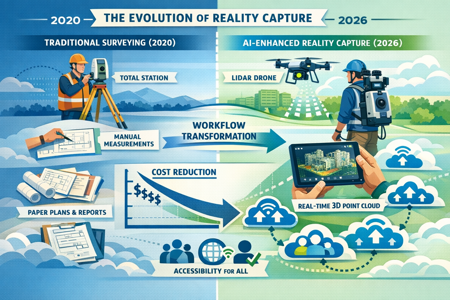
The property surveying industry stands at a transformative crossroads in 2026. What was once considered cutting-edge technology reserved for large-scale infrastructure projects has now become accessible, affordable, and essential for surveying firms of all sizes. Reality Capture Goes Mainstream: Integrating 3D Scanning and AI into Property Surveying Workflows in 2026 represents more than just technological advancement—it signals a fundamental shift in how professionals document, analyze, and communicate spatial information. Gone are the days when reality capture required substantial capital investment and specialized expertise. Today's AI-enhanced tools, cloud-based collaboration platforms, and user-friendly hardware have democratized access to engineering-grade precision, enabling surveyors to deliver faster, safer, and more comprehensive property assessments than ever before.
This mainstream adoption is reshaping every aspect of property surveying workflows. Firms that once relied solely on traditional measurement techniques now integrate 3D laser scanning, photogrammetry, drone-based LiDAR, and 360° imagery into their standard operating procedures. The convergence of artificial intelligence with reality capture technology has automated routine tasks, reduced human error, and accelerated project timelines dramatically. Meanwhile, cloud platforms enable real-time collaboration among stakeholders who may be thousands of miles apart, transforming spatial data into a universal visual language that bridges technical and non-technical audiences alike.
Key Takeaways
-
🚀 Reality capture technology has transitioned from experimental to standard practice in 2026, with organizations establishing repeatable capture schedules and quality control processes that integrate directly into digital twins for design, compliance, and asset management.
-
💰 Democratization of tools has accelerated dramatically, making reality capture affordable and accessible to surveying firms of all sizes through user-friendly equipment, broader platform support, and significantly reduced costs.
-
🤖 AI and cloud convergence is fundamentally transforming workflows, with automated systems handling routine tasks while enabling real-time collaboration and providing stronger audit trails for compliance and stakeholder engagement.
-
📊 Integrated capture combining LiDAR, 360° imagery, and emerging technologies like Gaussian Splatting delivers comprehensive spatial data that accelerates decision-making and improves communication across teams with varying technical expertise.
-
⚡ Enhanced precision, safety, and efficiency are now core competitive advantages, with reality capture delivering engineering-grade accuracy while reducing time on-site and minimizing risks in hazardous environments.
The Evolution from Pilot Projects to Standard Practice in 2026
Reality Capture Transitions from Experimental to Essential
The journey of Reality Capture Goes Mainstream: Integrating 3D Scanning and AI into Property Surveying Workflows in 2026 began years ago with pilot projects and experimental implementations. However, 2026 marks the year when these technologies have firmly established themselves as indispensable components of professional surveying practice. Organizations across the industry have moved beyond the testing phase to establish repeatable capture schedules with tightened quality control processes.[1]
This transition reflects a maturation of both technology and methodology. Surveying firms now wire reality capture data directly into digital twins for design, compliance, and long-term asset management.[1] What distinguishes 2026 from previous years is the systematic integration of these workflows into every phase of property assessment—from initial site documentation through ongoing maintenance and renovation planning.
The shift has been driven by tangible business outcomes. Firms report significant reductions in project timelines, improved accuracy in measurements, and enhanced client satisfaction through better visualization and communication. When conducting a Level 3 full building survey, reality capture technology enables surveyors to document every detail with unprecedented precision while spending less time on-site in potentially hazardous conditions.
National-Scale Implementation and Standardization
The maturation of reality capture in 2026 extends beyond individual firms to industry-wide standardization efforts. Organizations are implementing national basemaps at 5cm and 12.5cm resolution that feed automated extraction and predictive models.[1] These high-resolution basemaps provide foundational spatial data that supports everything from urban planning to infrastructure maintenance.
Mobile mapping outputs now provide street-level context and asset detail that complement traditional surveying methods.[1] This multi-scale approach—combining aerial, mobile, and terrestrial capture—creates comprehensive spatial datasets that serve diverse stakeholder needs. For professionals conducting measured building surveys, these integrated datasets provide contextual information that enhances understanding of individual properties within their broader environment.
The standardization of data formats and processing workflows has also accelerated adoption. Industry bodies have established best practices for quality control, data validation, and deliverable specifications that ensure consistency across projects and providers.
From Capital-Intensive to Accessible Technology
Perhaps the most significant factor enabling mainstream adoption is the dramatic democratization of reality capture technology.[2] Equipment that once required six-figure investments is now available at price points accessible to small and medium-sized surveying firms. This democratization extends beyond hardware costs to include:
- User-friendly software interfaces that require minimal specialized training
- Cloud-based processing that eliminates the need for expensive local computing infrastructure
- Subscription-based pricing models that convert capital expenditure to manageable operational costs
- Broader platform support enabling integration with existing surveying and CAD tools
The accessibility revolution means that firms of all sizes can now compete on technological capability rather than capital resources alone. A two-person surveying practice can deploy the same reality capture technologies that were once exclusive to multinational engineering firms.
How AI and Cloud Platforms Are Transforming Property Surveying Workflows
Artificial Intelligence as a Collaborative Partner
Reality Capture Goes Mainstream: Integrating 3D Scanning and AI into Property Surveying Workflows in 2026 is fundamentally powered by artificial intelligence that serves as a collaborative partner rather than a replacement for human expertise. AI and machine learning systems now handle routine surveying tasks automatically, freeing professionals to focus on complex problem-solving and client relationships.[2]
Modern AI applications in reality capture include:
| AI Application | Function | Benefit |
|---|---|---|
| Automated Feature Extraction | Identifies walls, doors, windows, utilities from point clouds | Reduces manual processing time by 60-80% |
| Defect Detection | Recognizes cracks, moisture damage, structural issues | Improves consistency and catches issues human eyes might miss |
| Classification and Segmentation | Categorizes building elements and materials | Enables automated quantity takeoffs and material assessments |
| Change Detection | Compares scans over time to identify alterations | Supports progress monitoring and compliance verification |
| Measurement Automation | Generates dimensions, areas, volumes automatically | Eliminates manual measurement errors and accelerates deliverable production |
These AI capabilities transform the surveyor's role from data collector to strategic advisor embedded in project teams from conception through long-term asset management.[2] When assessing building problems and solutions, AI-enhanced analysis helps identify patterns and correlations that might escape notice during manual inspection.
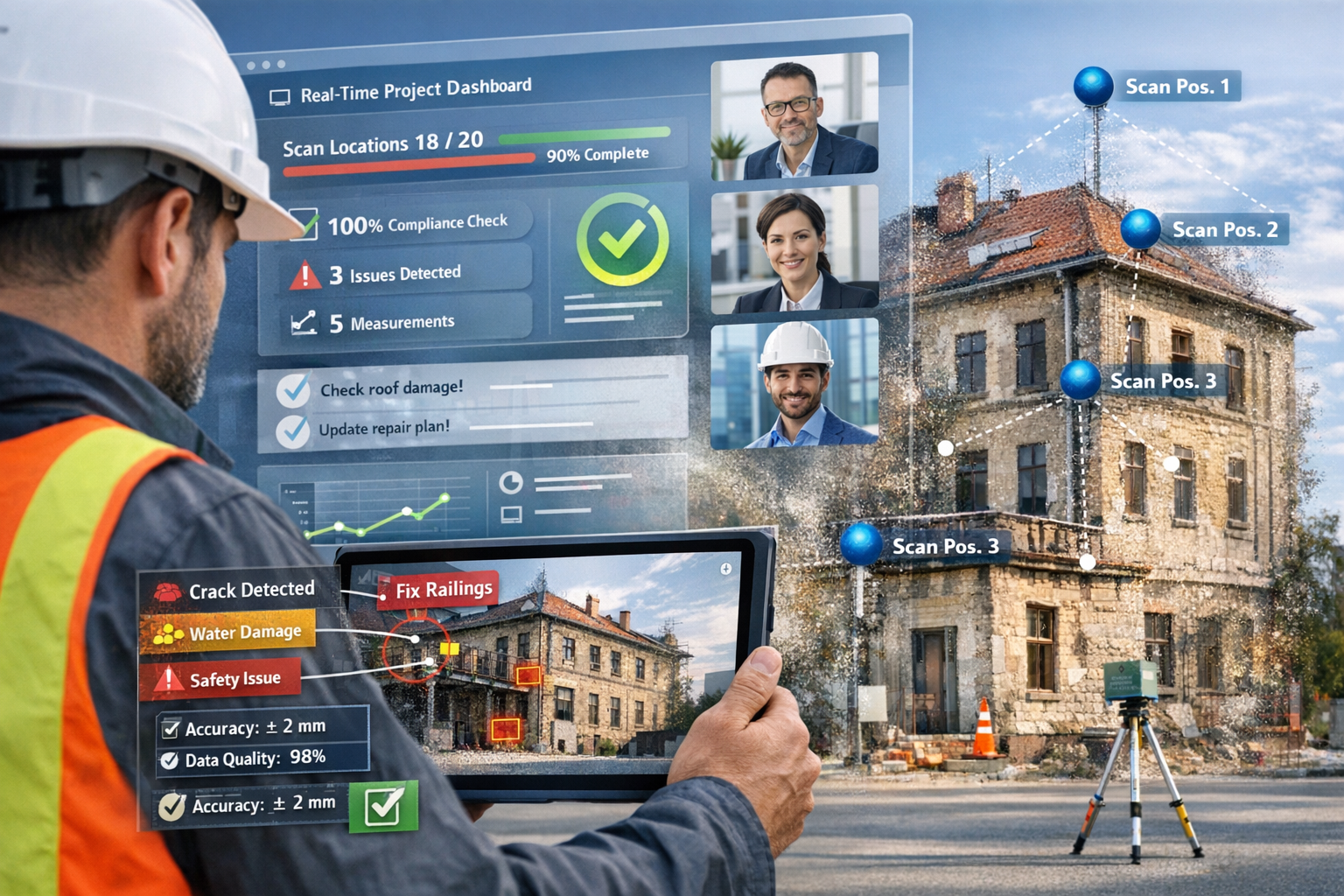
Cloud-Based Collaboration Revolutionizing Project Management
The convergence of reality capture with cloud-based collaboration platforms has fundamentally transformed how spatial data is captured, processed, and shared across teams and stakeholders.[2] Cloud platforms enable surveyors to:
✅ Document conditions in real-time and share findings immediately with clients and consultants
✅ Visually track progress across construction or renovation projects with timestamped spatial records
✅ Collaborate on solutions by annotating 3D models and sharing observations across distributed teams
✅ Maintain comprehensive audit trails showing who accessed data, when, and what changes were made
This real-time collaboration capability addresses one of the most persistent challenges in property surveying: communication gaps between technical specialists and non-technical stakeholders. Spatial data serves as a common visual language that helps all parties understand conditions, requirements, and proposed solutions without requiring specialized training.[2]
For firms managing multiple projects simultaneously, cloud platforms provide centralized dashboards that track progress, flag issues requiring attention, and ensure nothing falls through the cracks. When coordinating budgeting for repairs and restoration, stakeholders can reference the same spatial data to ensure accurate cost estimates and scope definitions.
Data Trust and Auditability as Competitive Differentiators
In 2026, organizations are prioritizing transparent records of data sources and processing methods so teams can trust results and justify decisions with confidence.[1] This emphasis on data trust and auditability has become a competitive differentiator as clients increasingly demand verifiable documentation for compliance, insurance, and legal purposes.
Modern reality capture workflows incorporate metadata tracking that documents:
- Capture parameters (equipment used, resolution settings, environmental conditions)
- Processing methods (algorithms applied, quality control checks performed)
- Accuracy assessments (precision metrics, validation against control points)
- Chain of custody (who captured data, when, and under what circumstances)
This comprehensive documentation supports compliance requirements across industries and provides stakeholders with confidence in the reliability of survey findings. When conducting drone surveys, detailed metadata ensures that captured data meets regulatory standards and can withstand scrutiny in legal or insurance contexts.
The auditability of AI-enhanced workflows also addresses concerns about "black box" decision-making. Modern systems provide explainable AI outputs that show how automated detections and classifications were determined, allowing human experts to validate and override automated findings when necessary.
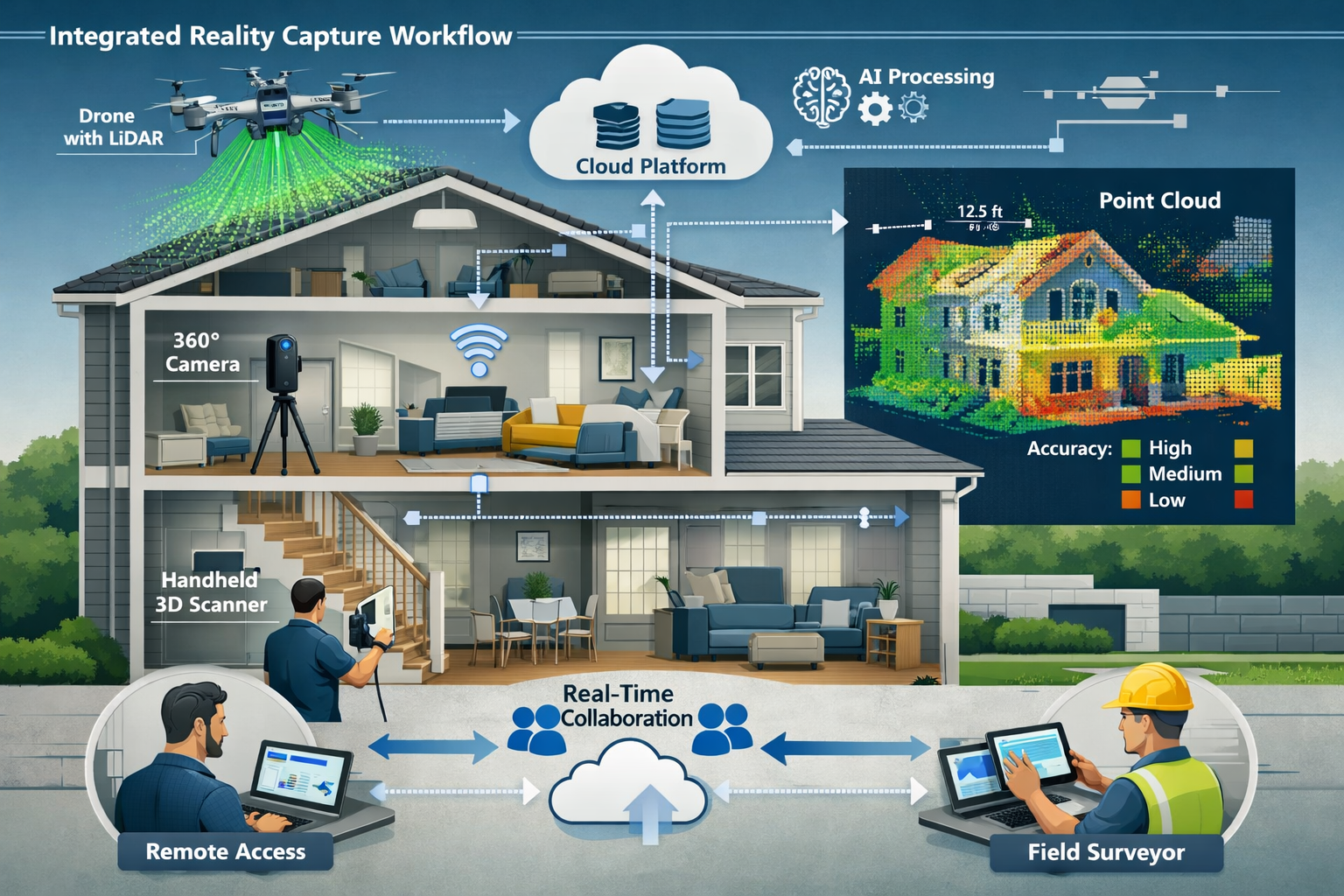
Integrated Technologies: LiDAR, 360° Imagery, Drones, and Emerging Innovations
The Growing Demand for Integrated Capture Systems
Reality Capture Goes Mainstream: Integrating 3D Scanning and AI into Property Surveying Workflows in 2026 is characterized by the adoption of integrated systems that combine multiple capture technologies to balance resolution requirements with practical implementation constraints.[5] The industry has recognized that no single technology serves all purposes optimally—instead, the most effective workflows leverage the complementary strengths of different approaches.
The demand for integrated capture combining LiDAR and 360° imagery continues to grow because this combination adds clarity and auditability that neither technology provides alone.[1][5] LiDAR delivers precise geometric measurements, while 360° imagery provides visual context, texture information, and intuitive navigation that accelerates decision-making.
This integrated approach particularly benefits communication with stakeholders who have varying technical skill levels. While engineers may work directly with point cloud data, clients and non-technical team members often find 360° imagery more accessible and understandable. The combination ensures that all stakeholders can engage meaningfully with survey findings.
LiDAR Technology: Engineering-Grade Precision at Speed
LiDAR (Light Detection and Ranging) technology delivers engineering-grade point clouds that capture millions of precise measurements in minutes.[1] Modern terrestrial laser scanners achieve accuracy within millimeters while capturing complete building interiors or exteriors in a fraction of the time required for traditional measurement methods.
The key advantages of LiDAR in property surveying include:
🎯 Millimeter-level accuracy suitable for detailed architectural documentation and compliance verification
🎯 Comprehensive coverage capturing hard-to-reach areas and complex geometries without physical access
🎯 Objective documentation providing unbiased spatial records independent of operator interpretation
🎯 Long-range capability enabling capture of large properties or multi-building complexes efficiently
When performing building materials assessments, LiDAR point clouds provide precise geometric data that supports accurate quantity calculations and dimensional verification.
360° Imagery: Context and Communication Power
360° imagery is accelerating decision-making by providing context difficult to obtain from LiDAR or aerial imagery alone.[1][5] These immersive visual records enable stakeholders to virtually "walk through" properties, understanding spatial relationships and conditions intuitively.
The practical benefits of 360° imagery include:
- Rapid condition documentation capturing complete visual records in minutes
- Remote inspection capability allowing experts to assess properties without travel
- Progress tracking providing timestamped visual records of project evolution
- Client communication offering intuitive visualization that requires no technical expertise
- Dispute resolution providing objective visual evidence of conditions at specific points in time
Integration of 360° imagery with point cloud data creates spatially-anchored visual context where users can navigate through imagery while accessing precise measurements at any location. This combination proves particularly valuable when addressing questions during building survey consultations.
Drone and UAV Deployment: Expanding Accessibility and Scale
Drone and UAV usage in surveying has skyrocketed as costs have decreased and accessibility improved.[4] UAVs equipped with high-resolution cameras and LiDAR sensors are now capable of capturing large-scale data efficiently, including photogrammetry, 3D mapping, thermal imaging, and building information modeling (BIM) integration.
The expansion of drone-based reality capture addresses several traditional surveying challenges:
| Challenge | Drone Solution | Benefit |
|---|---|---|
| Roof access safety | Aerial inspection without physical access | Eliminates fall risks and scaffolding costs |
| Large property coverage | Rapid aerial mapping of extensive sites | Reduces survey time from days to hours |
| Inaccessible areas | Capture of facades, chimneys, difficult terrain | Complete documentation without access limitations |
| Thermal analysis | Infrared imaging for insulation and moisture | Non-invasive defect detection |
| Progress monitoring | Regular aerial surveys tracking construction | Objective timeline documentation |
For professionals conducting roofing surveys, drone-based inspection provides comprehensive documentation while eliminating the safety risks associated with physical roof access. The combination of visual imagery and thermal analysis enables identification of issues invisible from ground level.
Gaussian Splatting: The Emerging Technology Gaining Professional Recognition
One of the most exciting developments in Reality Capture Goes Mainstream: Integrating 3D Scanning and AI into Property Surveying Workflows in 2026 is the professional adoption of Gaussian Splatting. This innovative rendering technique is now receiving native support in major GIS tools such as ArcGIS, driving adoption into professional workflows.[5]
Gaussian Splatting offers several advantages over traditional photogrammetric reconstruction:
✨ Photorealistic rendering quality that exceeds traditional mesh-based approaches
✨ Significantly smaller file sizes enabling easier sharing and cloud collaboration
✨ Faster processing times reducing the gap between capture and deliverable production
✨ Improved rendering performance allowing smooth navigation of complex scenes
The technology's fidelity, realism, and rendering improvements are advancing rapidly while file sizes shrink, leading to exponential growth in capability and interest.[5] However, industry best practices recognize that Gaussian Splatting should support measurements when backed by photogrammetric context rather than serving as the sole measurement authority.[5]
This measured approach to adoption reflects the surveying profession's commitment to accuracy and reliability. While Gaussian Splatting excels at visualization and communication, professionals continue to rely on LiDAR and traditional photogrammetry for precision measurements where accuracy is critical.
Mobile Mapping Systems: Street-Level Context and Asset Detail
Mobile mapping systems represent another key component of integrated reality capture workflows. These vehicle-mounted or backpack-mounted systems combine multiple sensors—typically including LiDAR, cameras, and GNSS positioning—to capture continuous spatial data as operators move through environments.
Mobile mapping outputs provide street-level context and asset detail that complement aerial and terrestrial capture methods.[1] The technology proves particularly valuable for:
- Urban corridor documentation capturing complete streetscapes efficiently
- Infrastructure asset inventories documenting utilities, signage, street furniture
- Right-of-way surveys providing comprehensive spatial records for planning and compliance
- As-built verification comparing constructed conditions against design intent
The integration of mobile mapping with other capture technologies creates multi-scale spatial datasets that serve diverse analytical needs. A single project might combine aerial drone mapping for overall site context, mobile mapping for access routes and surroundings, and terrestrial scanning for detailed building documentation.
Real-World Applications and Workflow Integration in Property Surveying
Streamlining Traditional Building Survey Workflows
The integration of reality capture technologies has fundamentally transformed traditional building survey workflows. Where conventional surveys might require multiple site visits and extensive manual measurement, modern approaches combine rapid on-site capture with detailed off-site analysis.
A typical AI-enhanced reality capture workflow for property surveying in 2026 includes:
1. Pre-Survey Planning 📋
- Review available data (plans, previous surveys, client concerns)
- Determine optimal capture strategy (LiDAR, 360°, drone, or combination)
- Schedule efficient site access minimizing disruption
2. On-Site Capture 📸
- Deploy integrated capture systems (often 30-60 minutes for typical residential property)
- Capture LiDAR point clouds for geometric accuracy
- Record 360° imagery for visual context and documentation
- Conduct drone survey for roof and exterior assessment when appropriate
- Perform targeted traditional measurements for verification
3. Cloud Upload and Processing ☁️
- Upload raw data to cloud platform immediately upon completion
- AI systems automatically process and classify captured data
- Automated quality control flags potential issues or gaps
- Initial deliverables available within hours rather than days
4. Analysis and Reporting 📊
- Surveyors review AI-generated findings and add professional judgment
- Extract measurements, identify defects, assess conditions
- Create annotated deliverables with visual references
- Generate comprehensive reports with embedded 3D visualizations
5. Client Collaboration 🤝
- Share interactive 3D models via cloud platform
- Conduct virtual walkthroughs highlighting key findings
- Enable client questions and annotations directly on spatial data
- Maintain complete audit trail of communications and decisions
This streamlined workflow significantly reduces the time required for building survey completion while improving the comprehensiveness and accuracy of findings.
Enhanced Safety for High-Risk Surveying Scenarios
Reality capture delivers engineering-grade point clouds and 360° imagery at speed, enabling faster and safer surveys for high-risk corridors and urban programs.[1] The safety advantages extend across multiple scenarios:
Roof and Elevation Inspection 🏠
- Drone-based capture eliminates fall risks associated with physical roof access
- Thermal imaging identifies moisture and insulation issues without contact
- Detailed visual documentation supports accurate assessment without scaffolding
Structural Concern Documentation ⚠️
- Laser scanning captures precise measurements of cracks, settlement, deformation
- Remote capture minimizes time spent in potentially unstable structures
- Complete spatial records support engineering analysis without repeated site visits
Hazardous Material Assessment 🔬
- Initial reality capture identifies potential asbestos-containing materials for targeted sampling
- Minimizes surveyor exposure to potentially harmful substances
- Provides spatial context for remediation planning
Traffic and Access Constraints 🚧
- Mobile mapping captures roadway and right-of-way data with minimal traffic disruption
- Rapid terrestrial scanning reduces time surveyors spend in active construction zones
- Drone surveys document sites with limited or hazardous access
The safety benefits translate directly to reduced insurance costs, improved employee wellbeing, and enhanced professional liability protection for surveying firms.
Supporting Property Development and Renovation Planning
Reality capture technology has become indispensable for property development and renovation planning. Developers and architects rely on accurate as-built documentation to inform design decisions, identify constraints, and estimate costs accurately.
Key applications include:
Renovation and Conversion Projects 🔨
- Precise as-built documentation reveals actual conditions versus original plans
- 3D models support design development and clash detection
- Accurate measurements enable reliable material quantity takeoffs
- Visual documentation helps contractors understand scope before bidding
Historic Building Documentation 🏛️
- Non-invasive capture preserves detailed records of heritage structures
- Supports conservation planning and regulatory compliance
- Enables virtual access for researchers and the public
- Provides baseline documentation for monitoring structural health over time
Space Planning and Fit-Out 📐
- Accurate floor plans and ceiling heights inform space utilization studies
- 3D visualization helps stakeholders evaluate design options
- Clash detection identifies conflicts between proposed systems and existing structure
- As-built verification ensures installations match design intent
When preparing properties for market, reality capture deliverables provide prospective buyers and tenants with comprehensive spatial information that accelerates decision-making and reduces transaction risks.
Compliance, Insurance, and Legal Documentation
The audit trail and documentation capabilities of reality capture technology address critical needs in compliance, insurance, and legal contexts. The transparent records of data sources and processing methods enable teams to trust results and justify decisions with confidence.[1]
Regulatory Compliance ✅
- Timestamped spatial records document conditions at specific points in time
- Precise measurements verify compliance with building codes and regulations
- Complete documentation supports permit applications and approvals
- Audit trails demonstrate due diligence in professional practice
Insurance Applications 🛡️
- Pre-loss documentation establishes baseline conditions for claims
- Post-incident capture provides objective evidence of damage extent
- Accurate measurements support reliable repair cost estimates
- Visual records reduce disputes between insurers and policyholders
Legal and Dispute Resolution ⚖️
- Objective spatial data provides neutral evidence in boundary disputes
- Condition documentation supports dilapidation claims and defenses
- Timeline visualization tracks project progress and identifies delays
- Expert witness testimony backed by verifiable spatial data
Party Wall Documentation 🧱
- Precise party wall schedules of condition document pre-construction state
- Regular monitoring captures any changes during adjacent construction
- Visual evidence reduces disputes between neighbors
- Comprehensive records support party wall awards and agreements
The evidentiary value of reality capture data has been increasingly recognized in legal proceedings, with courts accepting properly documented spatial data as reliable evidence of conditions and changes over time.
Overcoming Implementation Challenges and Best Practices
Balancing Technology Investment with Business Returns
While reality capture technology has become more accessible, surveying firms still face decisions about which tools to adopt and when. The key to successful implementation lies in aligning technology investment with specific business objectives and client needs.
Strategic Implementation Considerations:
💡 Start with High-Impact Applications
- Identify which survey types benefit most from reality capture (complex buildings, hazardous access, large properties)
- Calculate time savings and safety improvements for specific project types
- Pilot technology on projects where value proposition is clearest
💡 Consider Rental and Service Options
- Equipment rental for occasional specialized needs
- Outsourced capture services for projects requiring advanced capabilities
- Gradual transition from rental to ownership as demand grows
💡 Invest in Training and Workflow Development
- Technology value depends on operator competence and workflow efficiency
- Allocate resources for staff training and certification
- Document standard operating procedures for consistency
💡 Evaluate Total Cost of Ownership
- Consider software subscriptions, processing costs, storage requirements
- Account for ongoing maintenance and equipment updates
- Calculate fully-loaded costs including staff time and training
Firms that approach implementation strategically report return on investment within 6-12 months through reduced survey time, improved win rates on competitive projects, and enhanced client satisfaction.
Data Management and Processing Infrastructure
The volume of data generated by reality capture workflows presents both opportunities and challenges. A single building survey might produce gigabytes of point cloud data, hundreds of 360° images, and extensive metadata—all of which must be stored, processed, and delivered efficiently.
Best Practices for Data Management:
Cloud-First Architecture ☁️
- Leverage cloud storage for scalability and accessibility
- Enable remote team access to project data
- Implement automated backup and disaster recovery
- Consider data sovereignty and client confidentiality requirements
Standardized Naming and Organization 📁
- Develop consistent file naming conventions
- Organize data by project, date, capture method
- Tag data with searchable metadata
- Maintain clear version control for processed deliverables
Processing Workflow Optimization ⚙️
- Utilize cloud-based processing to avoid local hardware bottlenecks
- Implement quality control checkpoints throughout workflow
- Automate routine processing tasks where possible
- Balance processing quality with delivery timeline requirements
Long-Term Archive Strategy 🗄️
- Determine data retention requirements (legal, professional, client)
- Implement tiered storage (active projects, archive, long-term preservation)
- Plan for format migration as technologies evolve
- Document data provenance for future reference
Effective data management ensures that the value of captured spatial information extends beyond individual projects, creating organizational knowledge assets that support future work and continuous improvement.
Quality Control and Professional Standards
As Reality Capture Goes Mainstream: Integrating 3D Scanning and AI into Property Surveying Workflows in 2026, maintaining professional standards and quality control becomes increasingly important. The ease of data capture can create false confidence—proper implementation requires rigorous verification and validation.
Essential Quality Control Measures:
✓ Calibration and Verification
- Regular equipment calibration according to manufacturer specifications
- Validation against known control points and measurements
- Documentation of accuracy assessment for each project
- Comparison between different capture methods for cross-validation
✓ Operator Competency
- Formal training and certification for reality capture operators
- Ongoing professional development as technologies evolve
- Clear understanding of equipment limitations and error sources
- Adherence to professional surveying standards and ethics
✓ AI Output Validation
- Human review of automated feature extraction and classification
- Verification of AI-detected defects and anomalies
- Documentation of when automated findings are overridden
- Continuous feedback to improve AI model performance
✓ Deliverable Review
- Multi-stage review process before client delivery
- Peer review for complex or high-stakes projects
- Client feedback integration and continuous improvement
- Maintenance of professional indemnity insurance appropriate to technology use
Professional bodies and industry organizations continue to develop standards and guidance for reality capture implementation, ensuring that technological advancement enhances rather than compromises professional quality and accountability.
Integration with Existing Workflows and Legacy Systems
For established surveying firms, the challenge often lies not in adopting new technology but in integrating reality capture with existing workflows, software platforms, and client expectations. Successful integration requires thoughtful planning and gradual implementation.
Integration Strategies:
Hybrid Workflows 🔄
- Combine reality capture with traditional methods during transition period
- Use reality capture to verify and supplement conventional measurements
- Gradually expand reality capture scope as confidence and capability grow
- Maintain traditional capabilities for clients requiring specific deliverable formats
Software Ecosystem Compatibility 💻
- Ensure reality capture outputs integrate with existing CAD and GIS platforms
- Evaluate interoperability with client systems and requirements
- Invest in translation and conversion tools where necessary
- Standardize on file formats with broad industry support
Client Education and Expectation Management 📢
- Communicate benefits and capabilities of reality capture deliverables
- Provide sample outputs and demonstrations
- Offer both traditional and enhanced deliverable options
- Gather client feedback to refine offerings
Gradual Capability Expansion 📈
- Begin with basic capture and processing
- Add advanced features (AI analysis, cloud collaboration) as team develops expertise
- Expand to additional capture methods (drones, mobile mapping) based on demand
- Continuously evaluate emerging technologies for future adoption
The most successful implementations view reality capture not as a replacement for traditional surveying but as a complementary capability that enhances overall service quality and efficiency.
The Future Trajectory: What Comes Next for Reality Capture in Property Surveying
Continued AI Advancement and Automation
The trajectory of Reality Capture Goes Mainstream: Integrating 3D Scanning and AI into Property Surveying Workflows in 2026 points toward even greater AI capabilities in the coming years. Current AI systems handle feature extraction, defect detection, and classification—future systems will provide increasingly sophisticated analysis and predictive capabilities.
Emerging AI Applications:
🔮 Predictive Maintenance
- AI analysis of spatial data trends identifying deterioration patterns
- Early warning systems for structural concerns
- Maintenance scheduling optimization based on condition trajectories
🔮 Automated Code Compliance Checking
- AI comparison of as-built conditions against building regulations
- Automated identification of non-compliant elements
- Regulatory reporting generation with supporting spatial evidence
🔮 Energy Performance Modeling
- Integration of thermal imaging with geometric data
- AI-driven energy efficiency recommendations
- Retrofit planning optimization
🔮 Natural Language Interfaces
- Conversational queries of spatial data ("Show me all cracks wider than 5mm")
- Automated report generation from spatial analysis
- Voice-guided site capture and documentation
As AI capabilities expand, the surveyor's role will continue evolving toward strategic interpretation, client advisory, and quality oversight of increasingly automated technical processes.
Extended Reality and Immersive Collaboration
The convergence of reality capture with extended reality (XR) technologies—including virtual reality (VR) and augmented reality (AR)—promises to transform how stakeholders interact with spatial data. Already emerging in 2026, these applications will become increasingly mainstream in coming years.
XR Applications in Property Surveying:
Virtual Site Visits 🥽
- Immersive VR walkthroughs of captured properties
- Remote inspection and assessment without travel
- Collaborative virtual meetings within spatial data
- Training and education using real project data
Augmented On-Site Guidance 📱
- AR overlays showing design intent versus as-built conditions
- Real-time guidance for capture operators
- On-site visualization of proposed renovations
- Utility and infrastructure visualization beneath surfaces
Mixed Reality Collaboration 🌐
- Distributed teams collaborating within shared spatial environment
- Real-time annotation and markup visible to all participants
- Integration of spatial data with project management systems
- Decision-making supported by immersive spatial context
These immersive technologies will further democratize access to spatial information, enabling stakeholders with no technical training to engage meaningfully with complex spatial data.
Sensor Fusion and Multi-Modal Capture
The future of reality capture lies in increasingly sophisticated sensor fusion that combines multiple capture modalities into unified spatial datasets. Beyond simple integration of LiDAR and imagery, emerging systems will incorporate:
- Thermal and multispectral imaging for material analysis and condition assessment
- Ground-penetrating radar for subsurface utility and structural documentation
- Acoustic sensors for material identification and void detection
- Environmental sensors capturing temperature, humidity, air quality data
- IoT device integration linking spatial data with ongoing monitoring systems
This multi-modal approach will create comprehensive digital representations that capture not just geometry and appearance but also material properties, environmental conditions, and temporal changes.
Sustainability and Environmental Applications
Reality capture technology is increasingly recognized as essential for sustainability assessment and environmental monitoring. Applications include:
🌱 Energy Efficiency Assessment
- Thermal imaging identifying heat loss and insulation deficiencies
- Building envelope analysis supporting retrofit planning
- Solar potential assessment for renewable energy installation
🌱 Material Inventory and Circular Economy
- Detailed documentation of existing materials for reuse planning
- Waste reduction through accurate quantity takeoffs
- Deconstruction planning for material recovery
🌱 Green Infrastructure Monitoring
- Vegetation mapping and health assessment
- Stormwater management system documentation
- Urban heat island analysis and mitigation planning
🌱 Climate Resilience Planning
- Flood risk assessment and modeling
- Structural vulnerability to extreme weather
- Adaptation strategy development and monitoring
As sustainability becomes increasingly central to property development and management, reality capture will serve as a foundational technology for environmental assessment and monitoring.
Conclusion: Embracing the Reality Capture Revolution
Reality Capture Goes Mainstream: Integrating 3D Scanning and AI into Property Surveying Workflows in 2026 represents far more than a technological trend—it signals a fundamental transformation in how property surveying professionals deliver value to clients. The convergence of accessible hardware, powerful AI, and collaborative cloud platforms has democratized capabilities once reserved for specialized applications, making engineering-grade precision and comprehensive documentation available to firms of all sizes.
The benefits are clear and compelling: reduced survey time, enhanced safety, improved accuracy, better client communication, and stronger professional documentation. Firms that embrace these technologies report not only operational efficiencies but also competitive advantages in winning projects, satisfying clients, and attracting talented professionals who want to work with cutting-edge tools.
Yet technology alone does not guarantee success. The most effective implementations combine advanced tools with professional judgment, rigorous quality control, and commitment to client service. Reality capture enhances the surveyor's capabilities but does not replace the expertise, experience, and ethical standards that define professional practice.
Actionable Next Steps for Surveying Professionals
For firms considering or expanding their reality capture capabilities, the following steps provide a practical roadmap:
1. Assess Current Capabilities and Needs 📊
- Evaluate which projects would benefit most from reality capture
- Identify gaps between current capabilities and client expectations
- Calculate potential time savings and quality improvements
- Determine budget available for technology investment
2. Start with Focused Pilot Projects 🎯
- Select projects where reality capture value is clear and measurable
- Consider equipment rental or service providers for initial implementations
- Document time, cost, and quality metrics compared to traditional methods
- Gather client feedback on deliverables and communication
3. Invest in Training and Expertise Development 📚
- Provide formal training for staff on equipment and software
- Develop standard operating procedures for capture and processing
- Encourage professional certification in reality capture technologies
- Allocate time for experimentation and skill development
4. Build Integrated Workflows 🔧
- Integrate reality capture with existing CAD, GIS, and project management systems
- Establish quality control checkpoints throughout workflows
- Develop deliverable templates and standards
- Create client communication materials explaining capabilities and benefits
5. Plan for Scalable Growth 📈
- Start with core capabilities (terrestrial scanning, 360° imagery)
- Expand to specialized applications (drones, mobile mapping) based on demand
- Evaluate emerging technologies (Gaussian Splatting, AI automation) for future adoption
- Continuously gather feedback and refine offerings
6. Engage with Professional Community 🤝
- Participate in industry forums and working groups
- Share experiences and learn from peers
- Stay informed about evolving standards and best practices
- Contribute to professional development of the broader surveying community
The reality capture revolution is not a future possibility—it is the present reality of professional property surveying in 2026. Firms that embrace these technologies thoughtfully and strategically position themselves not only for current success but for continued leadership as the industry continues to evolve.
Whether conducting a comprehensive Level 3 building survey, documenting conditions for property valuations, or supporting complex development projects, reality capture technology enables surveying professionals to deliver unprecedented value to clients while advancing the standards and capabilities of the profession as a whole.
The question is no longer whether to adopt reality capture, but how to implement it most effectively to serve clients, enhance professional practice, and contribute to the built environment's sustainable future. The tools are accessible, the benefits are proven, and the pathway forward is clear. The time to act is now.
References
[1] Geospatial Trends 2026 – https://www.getmapping.co.uk/geospatial-trends-2026/
[2] Doubling Down On Digital – https://amerisurv.com/2026/02/01/doubling-down-on-digital/
[3] Reality Capture Goes Mainstream Accessible Tools Transforming Property Surveys In 2026 – https://nottinghillsurveyors.com/blog/reality-capture-goes-mainstream-accessible-tools-transforming-property-surveys-in-2026
[4] The Future Of Land Surveying Technology And Upcoming Trends In 2026 – https://metricop.com/blogs/land-surveying/the-future-of-land-surveying-technology-and-upcoming-trends-in-2026
[5] 6 Geospatial Trends To Watch In 2026 Insights From Intergeo 2025 – https://www.mosaic51.com/community/6-geospatial-trends-to-watch-in-2026-insights-from-intergeo-2025/
[6] Reality Capture – https://www.autodesk.com/solutions/reality-capture
[7] Doubling Down On Digital Six 2026 Surveying Trends – https://www.laserinst.com/news/doubling-down-on-digital-six-2026-surveying-trends/