The land surveying industry has undergone a dramatic transformation. What once required weeks of manual fieldwork, expensive equipment, and multiple crew members can now be accomplished in hours with a single drone operator. As we navigate through 2026, Drones in Land Surveying: 2026 Advancements in UAVs, LiDAR, and Photogrammetry for Accurate Mapping represent not just an incremental improvement—they signal a complete revolution in how professionals capture, process, and deliver geospatial data.
The convergence of affordable drone technology, miniaturized LiDAR sensors, and artificial intelligence has democratized access to survey-grade accuracy. Projects that were once economically unfeasible due to traditional surveying costs are now routine operations. From topographic mapping of vast construction sites to detailed infrastructure inspections, unmanned aerial vehicles (UAVs) equipped with cutting-edge sensors are redefining industry standards and expectations.
Key Takeaways
- LiDAR technology has reached mainstream adoption in 2026, with dramatically reduced costs making it accessible for routine surveying projects, achieving centimeter-level accuracy for topographic surveys, forestry mapping, and volumetric analysis.[1]
- RTK/PPK GNSS integration enables real-time kinematic positioning with centimeter precision, significantly reducing or eliminating the need for ground control points while maintaining survey-grade accuracy.[1]
- AI-powered data processing automates tasks that previously required days or weeks of manual work, including feature extraction, point cloud classification, change detection, and defect identification.[1]
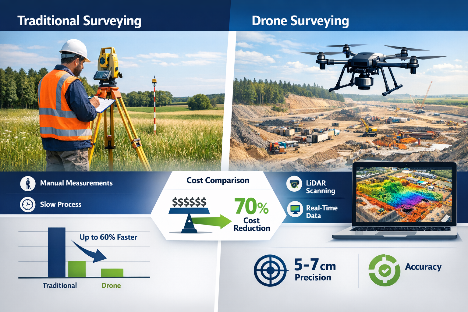
- Operational cost reductions of 70% or more compared to traditional surveying methods make drone surveys economically viable for periodic monitoring, progress assessment, and large-area mapping projects.[3]
- Beyond Visual Line of Sight (BVLOS) operations and autonomous systems are expanding commercial applications, enabling continuous infrastructure monitoring and remote site surveys without on-site pilots.[1]
The Evolution of Drone Technology in Land Surveying
From Experimental Tools to Survey-Grade Instruments
The journey of drones in land surveying has been remarkable. Early adopters in the mid-2010s faced significant challenges: expensive equipment, limited flight times, questionable accuracy, and regulatory uncertainty. Fast forward to 2026, and the landscape has completely transformed. Modern UAVs function as high-precision geospatial instruments that meet or exceed the accuracy standards of traditional ground-based surveying methods.[1]
This evolution stems from several technological breakthroughs:
Sensor Miniaturization and Integration 🔬
- High-resolution RGB cameras exceeding 100 megapixels
- Compact LiDAR sensors weighing less than 1 kilogram
- Multispectral and thermal imaging capabilities
- Advanced Inertial Measurement Units (IMUs) for precise positioning
Extended Flight Capabilities ✈️
- Battery technology enabling 45+ minute flight times
- Intelligent power management systems
- Automated battery swapping for continuous operations
- Weather-resistant designs for adverse conditions
Real-Time Data Processing 💻
- Onboard processing reducing post-flight workflow time
- Cloud-based data synchronization
- Edge computing for immediate quality control
- Mobile device integration for field verification
The maturation of regulatory frameworks has equally contributed to widespread adoption. FAA Part 107 certification improvements and the integration of Remote ID systems into airspace management have created a more predictable operational environment for commercial drone operations.[1]
Cost Accessibility: Breaking Down Barriers
One of the most significant developments in Drones in Land Surveying: 2026 Advancements in UAVs, LiDAR, and Photogrammetry for Accurate Mapping is the dramatic reduction in equipment costs. LiDAR sensors that cost $100,000+ just five years ago are now available for under $20,000, with entry-level photogrammetry-capable drones starting below $5,000.[1]
| Equipment Type | 2020 Cost | 2026 Cost | Cost Reduction |
|---|---|---|---|
| Survey-Grade Drone Platform | $15,000-$25,000 | $5,000-$12,000 | 60-67% |
| LiDAR Sensor System | $80,000-$150,000 | $15,000-$40,000 | 73-81% |
| RTK/PPK GNSS Module | $8,000-$15,000 | $2,000-$5,000 | 67-75% |
| Processing Software (Annual) | $5,000-$12,000 | $1,500-$4,000 | 67-70% |
This democratization of technology means that smaller surveying firms, construction companies, and even individual consultants can now afford professional-grade equipment that was previously accessible only to large organizations with substantial capital budgets.
LiDAR Technology: The Game-Changing Advancement
Understanding LiDAR in Drone Applications
Light Detection and Ranging (LiDAR) has emerged as the gold standard for topographic surveys in 2026. Unlike traditional photogrammetry that relies on visible surfaces, LiDAR uses laser pulses to create highly accurate three-dimensional point clouds, even penetrating vegetation to capture ground-level terrain.[1]
Modern drone-mounted LiDAR systems offer several compelling advantages:
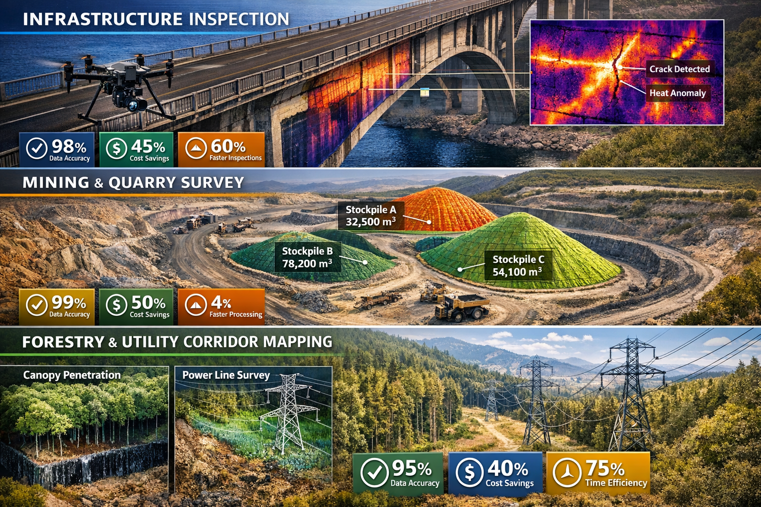
Canopy Penetration 🌲
LiDAR excels in forested areas where traditional photogrammetry fails. The laser pulses can penetrate gaps in tree canopy, capturing multiple returns that reveal both vegetation structure and bare earth terrain beneath. This capability has revolutionized forestry surveys, electric utility corridor mapping, and environmental assessments.[1]
Accuracy in Challenging Conditions ☁️
Unlike photogrammetry that requires optimal lighting conditions, LiDAR operates effectively in low-light situations, overcast conditions, and even light rain. This operational flexibility significantly reduces weather-related delays and expands the survey window.
Vertical Accuracy 📏
Survey-grade LiDAR systems now achieve vertical accuracy of ±2-5 centimeters and horizontal accuracy of ±5-10 centimeters when integrated with RTK/PPK GNSS positioning.[1] This precision meets or exceeds requirements for most civil engineering, construction, and land development applications.
Real-World LiDAR Applications and Case Studies
The practical applications of LiDAR-equipped drones span numerous industries:
Mining and Aggregates ⛏️
Volumetric calculations for stockpiles, pit progression monitoring, and haul road design have been transformed by LiDAR technology. A single drone flight can survey an entire quarry in 2-3 hours, generating accurate volume measurements within 1-2% of actual quantities—accuracy that previously required days of manual surveying.[1]
"A mining operation in Wales reduced survey costs by 78% and survey time from 5 days to 4 hours by switching from traditional methods to drone-based LiDAR, while actually improving accuracy from ±15cm to ±3cm." – Industry Case Study
Topographic Mapping 🗺️
Large-area topographic surveys for land development, master planning, and infrastructure design benefit enormously from LiDAR's speed and accuracy. Projects covering hundreds of acres that once required weeks of field time can now be completed in a single day of flight operations.
Flood Risk Assessment 🌊
High-resolution elevation models generated from LiDAR data enable sophisticated hydrological modeling for flood plain mapping, drainage design, and climate resilience planning. The ability to capture subtle elevation changes of just a few centimeters provides critical data for accurate water flow predictions.
For professionals conducting measured building surveys, the integration of drone-based LiDAR with traditional techniques creates comprehensive documentation that captures both exterior site conditions and detailed building measurements.
Photogrammetry: High-Resolution Mapping from the Sky
The Science Behind Aerial Photogrammetry
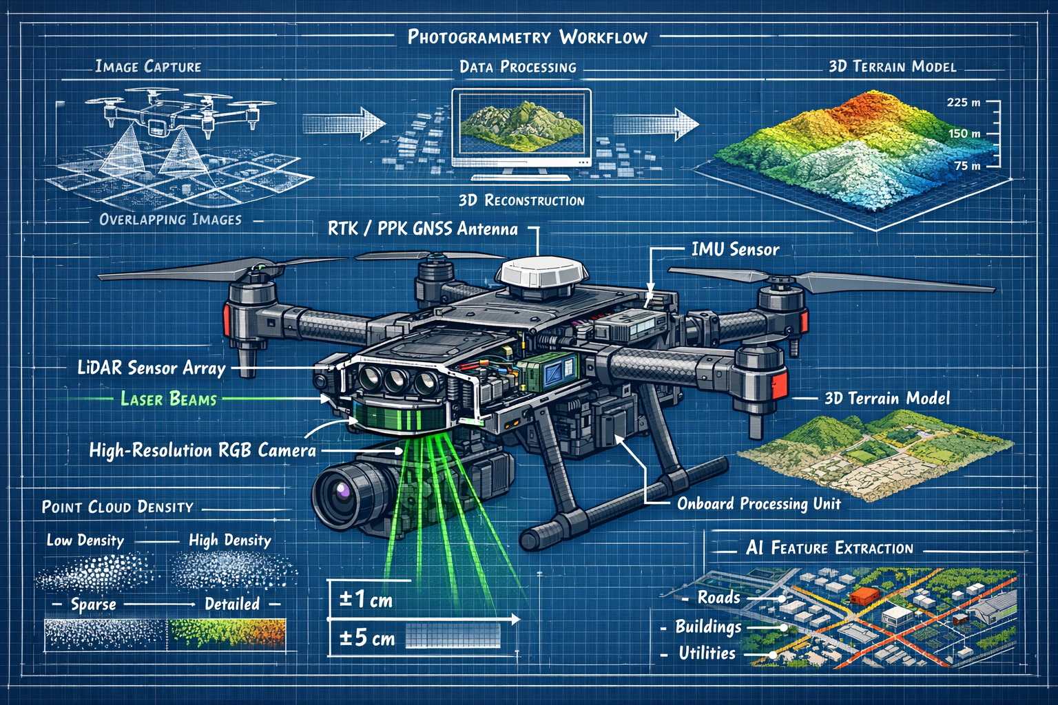
Photogrammetry—the science of making measurements from photographs—has been revolutionized by drone technology. Modern UAVs equipped with high-resolution cameras capture hundreds or thousands of overlapping images during a single flight. Sophisticated software then processes these images to create detailed 2D orthomosaics, 3D models, and digital elevation models.[3]
The photogrammetric workflow in 2026 follows these key steps:
- Flight Planning – Automated mission planning software calculates optimal flight paths, camera angles, and image overlap percentages
- Image Acquisition – Drones capture images with 70-80% forward overlap and 60-70% side overlap for complete coverage
- Ground Control – RTK/PPK positioning reduces or eliminates the need for traditional ground control points
- Processing – AI-powered software automatically aligns images, generates point clouds, and creates deliverable products
- Quality Control – Automated accuracy assessment and validation against checkpoints
Imaging Resolution and Detail Capture
The imaging quality achievable with modern drone photogrammetry significantly exceeds satellite imagery and even Google Earth data. Current systems routinely capture imagery with ground sample distance (GSD) of 1-2 centimeters per pixel, enabling identification of remarkably small features.[3][5]
What Can Be Identified at Different Resolutions:
- 1-2cm GSD: Individual pavement cracks, small drainage features, signage text, curb details, road markings
- 3-5cm GSD: Utility covers, hydrants, light poles, vegetation types, building features
- 5-10cm GSD: Vehicles, large equipment, building outlines, major terrain features
- 10-20cm GSD: General site conditions, land use classification, major infrastructure
This level of detail transforms how professionals approach site analysis. Engineers can identify potential drainage issues, planners can assess existing conditions without site visits, and construction managers can monitor progress with millimeter-level precision.
The high-resolution capabilities prove particularly valuable when combined with traditional surveying services. For instance, professionals conducting Level 3 building surveys can use drone imagery to assess roof conditions, chimney integrity, and external building fabric before detailed internal inspections.
Photogrammetry vs. LiDAR: Choosing the Right Technology
While both technologies produce three-dimensional data, they excel in different scenarios:
Choose Photogrammetry When:
- ✅ Budget constraints favor lower equipment costs
- ✅ Visual texture and color information are important
- ✅ Site has minimal vegetation or canopy cover
- ✅ Weather conditions are favorable (good lighting)
- ✅ Deliverables include orthophotos or visual documentation
Choose LiDAR When:
- ✅ Vegetation penetration is required
- ✅ Consistent accuracy regardless of lighting is critical
- ✅ Vertical surfaces or complex geometry must be captured
- ✅ Survey must occur during suboptimal weather conditions
- ✅ Bare earth terrain model beneath vegetation is needed
Hybrid Approach:
Many surveying projects in 2026 utilize both technologies simultaneously. Drones equipped with both RGB cameras and LiDAR sensors capture complementary datasets in a single flight, providing the accuracy and penetration of LiDAR with the visual context and texture of photogrammetry.[1]
RTK/PPK GNSS: Achieving Centimeter-Level Accuracy
The Positioning Revolution
Real-Time Kinematic (RTK) and Post-Processed Kinematic (PPK) GNSS technology represents one of the most transformative advancements in Drones in Land Surveying: 2026 Advancements in UAVs, LiDAR, and Photogrammetry for Accurate Mapping. These positioning systems enable centimeter-level accuracy without requiring extensive ground control point networks.[1]
RTK (Real-Time Kinematic):
- Receives correction data from a base station during flight
- Provides real-time positioning accuracy of ±2-5 centimeters
- Requires continuous radio communication with base station
- Ideal for smaller sites with reliable connectivity
PPK (Post-Processed Kinematic):
- Logs raw GNSS data during flight for post-processing
- Achieves similar accuracy to RTK through post-flight correction
- No real-time communication required
- Better suited for large sites, remote locations, or areas with communication challenges
Reducing Ground Control Point Requirements
Traditional photogrammetric surveys required numerous ground control points (GCPs)—precisely surveyed markers distributed throughout the project area. Establishing these GCPs was time-consuming, labor-intensive, and often represented a significant portion of total project costs.
RTK/PPK technology has dramatically reduced GCP requirements:[1]
Traditional Approach:
- 5-10 GCPs per 100 acres
- 2-4 hours of field time to establish and survey GCPs
- Required access to entire project area
- Challenging in remote or restricted locations
RTK/PPK Approach:
- 0-3 GCPs per 100 acres (primarily for validation)
- 30-60 minutes for checkpoint establishment
- Minimal site access requirements
- Feasible in previously inaccessible locations
This reduction proves particularly valuable for:
- Linear infrastructure projects (roads, pipelines, transmission lines) where traditional GCP placement was logistically challenging
- Remote locations where site access is difficult or expensive
- Emergency response mapping where speed is critical and GCP establishment impractical
- Periodic monitoring where consistent coordinate systems across multiple surveys are essential
The technology also benefits professionals involved in land valuation by enabling cost-effective topographic surveys that support accurate site assessment and development feasibility analysis.
AI-Powered Data Processing: Automating the Workflow
The Most Transformative Development
If hardware improvements have made drone surveying possible, artificial intelligence has made it practical at scale. AI-powered data processing represents the most transformative development in surveying technology in 2026, automating tasks that previously required skilled professionals to spend days or weeks on manual work.[1]
Key AI Applications in Survey Data Processing:
Automated Feature Extraction 🏗️
Modern AI algorithms automatically identify and classify features from point cloud and imagery data:
- Road centerlines and edge-of-pavement
- Building footprints and roof outlines
- Utility infrastructure (poles, transformers, manholes)
- Vegetation classification and tree inventory
- Drainage features and water bodies
Point Cloud Classification 📊
Machine learning models automatically classify LiDAR point clouds into standardized categories:
- Ground points
- Vegetation (low, medium, high)
- Buildings and structures
- Water surfaces
- Vehicles and temporary objects
This automated classification reduces processing time from days to hours while maintaining consistency and accuracy across large datasets.
Change Detection 🔍
AI-powered algorithms compare survey data from different time periods to automatically identify changes:
- Earthwork progress on construction sites
- Erosion or deposition in waterways
- Vegetation growth or removal
- New construction or demolition
- Stockpile volume changes
Defect Identification ⚠️
For infrastructure inspection applications, AI systems automatically detect and classify defects:
- Pavement cracks and spalling
- Bridge deck deterioration
- Corrosion on metal structures
- Thermal anomalies indicating equipment problems
- Alignment issues in linear infrastructure
Processing Speed and Efficiency Gains
The efficiency improvements from AI-powered processing are substantial:
| Task | Manual Processing | AI-Assisted Processing | Time Savings |
|---|---|---|---|
| Feature Extraction (100 acres) | 3-5 days | 2-4 hours | 90-95% |
| Point Cloud Classification | 2-3 days | 1-3 hours | 92-96% |
| Change Detection Analysis | 1-2 days | 30-60 minutes | 94-97% |
| Quality Control Review | 4-6 hours | 30-45 minutes | 85-90% |
These time savings translate directly to cost reductions and faster project delivery. Surveying firms can now offer services that were previously economically unviable, such as weekly progress monitoring for construction projects or monthly condition assessments for infrastructure assets.
Similar to how professionals conducting building materials assessments benefit from systematic evaluation frameworks, drone surveyors leverage AI to ensure consistent, comprehensive analysis across projects.
Cost Savings and Operational Efficiency
Quantifying the Economic Benefits
The economic case for Drones in Land Surveying: 2026 Advancements in UAVs, LiDAR, and Photogrammetry for Accurate Mapping is compelling. Operational costs are substantially lower than traditional surveying methods, with cost reductions of 70% or more common for appropriate applications.[3]
Cost Comparison: Traditional vs. Drone Surveying
100-Acre Topographic Survey:
Traditional Ground Survey:
- Field crew (3 people × 5 days): $12,000
- Equipment rental: $2,000
- Transportation and logistics: $1,500
- Processing and drafting (3 days): $3,000
- Total: $18,500
Drone Survey with Photogrammetry:
- Flight operations (1 pilot × 1 day): $1,200
- Equipment depreciation: $500
- Processing (AI-assisted, 4 hours): $400
- Quality control and deliverables: $800
- Total: $2,900
- Savings: $15,600 (84%)
Speed Advantages Transform Project Timelines
Beyond direct cost savings, the speed of drone surveying creates significant value through reduced project timelines. A single UAV mission can now survey hundreds of acres in hours, compared to traditional methods requiring days or weeks of manual effort and multiple field crews.[1][3]
Timeline Comparison Examples:
Mining Volumetric Survey (50-acre site):
- Traditional: 3-4 days field work + 2 days processing = 5-6 days
- Drone: 3 hours flight + 4 hours processing = 1 day
- Time savings: 80-85%
Highway Corridor Survey (5 miles):
- Traditional: 2 weeks field work + 1 week processing = 3 weeks
- Drone: 2 days flight + 2 days processing = 4 days
- Time savings: 81%
Construction Progress Monitoring (20-acre site):
- Traditional: Not economically feasible for monthly monitoring
- Drone: 2 hours per monthly survey
- Enables new service offering
This speed advantage proves particularly valuable for time-sensitive applications such as emergency response mapping, construction dispute resolution, and regulatory compliance documentation.
Enabling New Business Models
The reduced costs and increased efficiency of drone surveying enable entirely new business models and service offerings:
Subscription-Based Monitoring 📅
Regular monthly or quarterly surveys for construction projects, mining operations, or agricultural land management become economically viable. Clients receive consistent progress documentation and volumetric analysis at a fraction of traditional costs.
As-Built Verification ✔️
Contractors can now afford comprehensive as-built surveys for quality control and closeout documentation, reducing disputes and improving project delivery.
Periodic Asset Condition Assessment 🏭
Infrastructure owners can implement proactive maintenance programs based on regular drone inspections, identifying issues before they become critical failures.
These new service models align well with comprehensive property assessment approaches, similar to how building pathology services provide ongoing monitoring and early defect identification.
Infrastructure Inspection Applications
Beyond Traditional Surveying
While topographic mapping and volumetric surveys represent the most common applications, infrastructure inspection has become standard practice in 2026 for a wide range of assets.[1] Drones equipped with high-resolution zoom cameras, thermal sensors, and LiDAR identify structural issues without scaffolding, shutdowns, or putting personnel at risk.
Bridge Inspection 🌉
Traditional bridge inspections required expensive equipment (bucket trucks, scaffolding, or rope access teams) and often necessitated lane closures or complete shutdowns. Drone inspections now capture:
- Structural cracks in concrete and steel
- Spalling and delamination
- Corrosion on metal components
- Bearing condition and alignment
- Expansion joint functionality
- Deck drainage issues
High-resolution cameras with 30x optical zoom enable millimeter-level crack detection from safe distances, while thermal imaging identifies subsurface delamination invisible to visual inspection.
Power Transmission Infrastructure ⚡
Electric utilities have embraced drone technology for transmission line inspection:
- Conductor condition and corrosion
- Insulator damage or contamination
- Tower structural integrity
- Vegetation encroachment analysis
- Thermal anomalies indicating connection issues
- Right-of-way compliance verification
Autonomous flight systems follow transmission corridors for hundreds of miles, automatically capturing standardized imagery at each tower and identifying anomalies for human review.
Renewable Energy Facilities 🌞
Solar farms and wind turbines benefit from regular drone inspections:
Solar Farms:
- Thermal imaging identifies underperforming panels
- Visual inspection detects physical damage
- Vegetation management verification
- Inverter and electrical equipment condition
Wind Turbines:
- Blade surface inspection for cracks and erosion
- Lightning strike damage assessment
- Gearbox thermal monitoring
- Tower structural condition
Industrial Facility Applications
Oil and Gas Infrastructure 🛢️
Refineries, processing plants, and pipeline corridors utilize drones for:
- Flare stack inspection without shutdown
- Pressure vessel external condition assessment
- Pipeline corridor monitoring and leak detection
- Tank farm inspection and volumetrics
- Thermal imaging for insulation assessment
Commercial and Residential Property 🏢
The principles of drone inspection extend to building surveys, complementing traditional methods. Professionals conducting asbestos building surveys or general condition assessments use drones to safely inspect:
- Roof condition and remaining service life
- Chimney and parapet integrity
- External wall condition and water ingress points
- Gutter and drainage systems
- High-level architectural details
This approach proves particularly valuable when assessing properties where access is difficult or dangerous, providing comprehensive documentation without scaffolding or specialized access equipment.
Regulatory Environment and BVLOS Operations
Regulatory Maturation in 2026
The regulatory framework governing commercial drone operations has matured significantly, creating a more predictable environment for surveying applications. Beyond Visual Line of Sight (BVLOS) operations are increasingly approved for commercial use in 2026, with Remote ID fully integrated into airspace management systems.[1]
Key Regulatory Developments:
Remote ID Integration 📡
All commercial drones now broadcast identification and location information, enabling:
- Automated airspace deconfliction
- Enhanced safety through traffic awareness
- Simplified approval processes for routine operations
- Integration with manned aviation systems
BVLOS Approvals 🚁
Commercial operators can now obtain approvals for Beyond Visual Line of Sight operations under standardized criteria:
- Linear infrastructure surveys (pipelines, transmission lines, roads)
- Large-area agricultural or forestry surveys
- Emergency response and disaster assessment
- Routine inspection of remote facilities
These approvals eliminate the constraint that previously limited survey coverage to what a pilot could visually monitor, dramatically expanding the efficiency of linear corridor surveys.
Autonomous Operations 🤖
Drone-in-a-box systems that operate autonomously without on-site pilots are now common for:
- Scheduled infrastructure inspections
- Continuous construction monitoring
- Security and surveillance applications
- Environmental monitoring stations
Operational Best Practices
Professional drone surveying in 2026 follows established best practices that ensure safety, quality, and regulatory compliance:
Pre-Flight Planning ✈️
- Airspace authorization through automated systems
- Weather assessment and go/no-go criteria
- Risk assessment and mitigation planning
- Stakeholder notification and coordination
Flight Operations 🎯
- Redundant safety systems (dual GNSS, return-to-home)
- Real-time monitoring and quality control
- Automated obstacle avoidance
- Emergency procedure readiness
Data Management 💾
- Secure data storage and backup
- Chain of custody documentation
- Quality control and accuracy verification
- Client data delivery and archiving
These systematic approaches mirror the thoroughness expected in traditional surveying and align with professional standards across the industry, similar to comprehensive approaches used in areas requiring further investigation during building surveys.
Integration with Traditional Surveying Methods
Complementary Technologies, Not Replacements
Despite the remarkable capabilities of Drones in Land Surveying: 2026 Advancements in UAVs, LiDAR, and Photogrammetry for Accurate Mapping, drone technology complements rather than replaces traditional surveying methods. The most effective surveying practices in 2026 integrate multiple technologies based on project requirements.
When Traditional Methods Remain Essential:
Boundary Surveys 📐
Property boundary determination requires:
- Legal research and deed analysis
- Physical monument location and verification
- Precise angle and distance measurements
- Professional surveyor certification and stamping
Drones provide valuable context and topographic information but cannot replace the legal and technical requirements of boundary surveying.
Underground Utilities 🔍
Subsurface features remain invisible to aerial sensors, requiring:
- Ground-penetrating radar
- Electromagnetic locators
- Vacuum excavation for verification
- Manual survey of exposed utilities
Dense Urban Environments 🏙️
Tall buildings, narrow streets, and GNSS signal obstruction make traditional methods more effective in some urban contexts, though drones excel at capturing building facades and roof conditions.
Hybrid Workflows for Optimal Results
The most efficient surveying projects in 2026 employ hybrid workflows that leverage the strengths of each technology:
Large Site Development Project:
- Initial reconnaissance: Drone photogrammetry for overall site conditions
- Topographic base: Drone LiDAR for detailed terrain model
- Boundary verification: Traditional survey for property corners
- Utility investigation: Ground-based methods for subsurface features
- Final deliverable: Integrated dataset combining all sources
Infrastructure Corridor Survey:
- Aerial mapping: Drone survey of entire corridor
- Ground control: Traditional survey of key control points
- Structure details: Drone close-range inspection
- Subsurface features: Ground-based utility location
- Integrated model: Combined dataset for design
This integrated approach delivers comprehensive information more efficiently and cost-effectively than any single method alone.
Future Trends and Emerging Technologies
What's Next for Drone Surveying
While 2026 represents a mature stage of drone surveying technology, several emerging trends point toward continued advancement:
Swarm Technology 🐝
Multiple drones operating cooperatively will enable:
- Simultaneous multi-angle capture for complex structures
- Rapid large-area surveys with coordinated coverage
- Redundant data collection for critical applications
- Reduced survey time for time-sensitive projects
Enhanced Sensor Integration 📷
Next-generation platforms will combine:
- LiDAR, RGB, multispectral, and thermal sensors simultaneously
- Hyperspectral imaging for materials identification
- Ground-penetrating radar for shallow subsurface detection
- Gas detection sensors for environmental monitoring
Improved AI Capabilities 🧠
Artificial intelligence will advance to provide:
- Real-time quality control during flight operations
- Predictive maintenance for infrastructure assets
- Automated compliance verification against design plans
- Natural language query of survey databases
Extended Automation ⚙️
Fully autonomous systems will expand to include:
- Automated flight planning from project requirements
- Self-deploying charging stations for continuous operations
- Automatic data processing and deliverable generation
- Integration with Building Information Modeling (BIM) workflows
Preparing for the Future
Organizations seeking to maximize value from drone surveying technology should focus on:
Skill Development 📚
- Cross-training traditional surveyors in drone operations
- Developing expertise in data processing software
- Understanding AI-assisted workflows
- Maintaining regulatory compliance knowledge
Technology Investment 💰
- Selecting scalable platforms that accommodate sensor upgrades
- Investing in processing infrastructure and software
- Building data management and archiving systems
- Maintaining equipment through regular updates
Service Expansion 🚀
- Identifying new applications for existing clients
- Developing subscription-based monitoring services
- Offering value-added analysis and consulting
- Integrating with complementary services
These forward-looking strategies position surveying firms to capitalize on continuing technological advancement while delivering increasing value to clients.
Selecting the Right Equipment and Service Providers
Equipment Selection Criteria
For organizations considering investment in drone surveying capabilities, selecting appropriate equipment requires careful evaluation:
Platform Considerations 🚁
- Flight time: 30+ minutes for efficient site coverage
- Payload capacity: Sufficient for required sensors
- Weather resistance: IP rating appropriate for local conditions
- Portability: Transport and deployment requirements
- Reliability: Proven track record and support network
Sensor Selection 📸
- Photogrammetry: Minimum 20MP camera, mechanical shutter
- LiDAR: Point density, range, and accuracy specifications
- GNSS: RTK/PPK capability for survey-grade positioning
- Specialized sensors: Thermal, multispectral, or gas detection as needed
Software Requirements 💻
- Flight planning: Automated mission generation
- Processing: AI-assisted feature extraction and classification
- CAD integration: Export to industry-standard formats
- Cloud capability: Collaboration and data sharing
Choosing Service Providers
For clients requiring drone surveying services rather than in-house capabilities, selecting qualified providers involves:
Qualifications and Certifications ✅
- Licensed professional surveyors on staff
- FAA Part 107 Remote Pilot certification
- Insurance coverage (liability and equipment)
- Industry-specific experience and references
Technical Capabilities 🔧
- Appropriate equipment for project requirements
- Processing software and expertise
- Quality control procedures
- Deliverable format flexibility
Project Understanding 📋
- Clear scope definition and deliverables
- Realistic timeline and cost estimates
- Communication and progress reporting
- Problem-solving approach for challenges
Quality service providers demonstrate understanding of how drone surveys integrate with overall project goals, similar to how comprehensive building survey services consider timing, scope, and client needs throughout the process.
Case Studies: Real-World Applications and Results
Case Study 1: Large-Scale Residential Development
Project: 250-acre mixed-use development site
Challenge: Comprehensive topographic survey for master planning
Traditional Approach: 3-week field survey, $85,000 cost
Drone Solution: 2-day LiDAR survey with RTK positioning
Results:
- Cost: $12,500 (85% reduction)
- Timeline: 4 days total (82% reduction)
- Accuracy: ±3cm vertical, ±5cm horizontal
- Deliverables: 1-foot contours, digital terrain model, orthophoto
- Additional Value: Monthly progress monitoring throughout construction
The development team used the detailed terrain model for drainage design, earthwork optimization, and environmental impact assessment. Monthly drone surveys throughout construction provided progress documentation and volumetric analysis for earthwork verification.
Case Study 2: Highway Corridor Expansion
Project: 8-mile highway widening project
Challenge: Survey existing conditions including pavement, drainage, and right-of-way features
Traditional Approach: 4-week survey with traffic control, $120,000 cost
Drone Solution: Photogrammetry with ground control verification
Results:
- Cost: $28,000 (77% reduction)
- Timeline: 6 days (79% reduction)
- Safety: No lane closures or traffic control required
- Detail: Feature identification including signage, pavement markings, utilities
- Accuracy: Sufficient for preliminary and final design
The imaging resolution enabled designers to identify existing drainage structures, utility conflicts, and right-of-way features without extensive field investigation. The project team referenced the orthophoto throughout design, reducing field verification visits by 60%.
Case Study 3: Quarry Volumetric Monitoring
Project: Aggregate quarry with monthly production reporting requirements
Challenge: Accurate stockpile volumes for inventory management
Traditional Approach: Quarterly surveys only (cost prohibitive for monthly)
Drone Solution: Monthly photogrammetry surveys with automated processing
Results:
- Frequency: Monthly monitoring vs. quarterly (300% increase)
- Cost: $1,800/month vs. $8,500/quarter for traditional
- Accuracy: ±1.5% volume accuracy
- Automation: AI-powered stockpile identification and volume calculation
- Business Impact: Improved inventory management and production optimization
The quarry operator now has real-time inventory visibility, enabling better customer service, production planning, and financial reporting. The detailed historical data supports trend analysis and operational optimization.
Conclusion: Embracing the Future of Land Surveying
The transformation of land surveying through Drones in Land Surveying: 2026 Advancements in UAVs, LiDAR, and Photogrammetry for Accurate Mapping represents more than technological evolution—it signals a fundamental shift in how professionals capture, analyze, and deliver geospatial information. The convergence of affordable hardware, sophisticated sensors, RTK/PPK positioning, and AI-powered processing has democratized access to survey-grade accuracy while dramatically reducing costs and timelines.
The benefits extend beyond simple cost savings. Drone technology enables new service offerings, improves safety by eliminating hazardous access requirements, and provides comprehensive documentation that supports better decision-making throughout project lifecycles. From topographic mapping of vast development sites to detailed infrastructure inspections, UAVs have proven their value across virtually every surveying application.
Key Success Factors
Organizations successfully leveraging drone technology in 2026 share common characteristics:
Technical Competence 🎯
- Investment in appropriate equipment and software
- Ongoing training and skill development
- Quality control procedures and accuracy verification
- Integration with traditional surveying methods
Business Strategy 💼
- Clear understanding of applications and market opportunities
- Competitive pricing that reflects value delivered
- Client education about capabilities and limitations
- Continuous improvement and technology adoption
Professional Standards 📊
- Regulatory compliance and safety culture
- Professional licensure and certification
- Ethical practice and client service
- Industry engagement and knowledge sharing
Actionable Next Steps
For surveying professionals and organizations seeking to capitalize on drone technology:
Immediate Actions (Next 30 Days)
- Assess current capabilities: Evaluate existing equipment, skills, and service offerings
- Identify opportunities: Review current and potential projects suitable for drone surveying
- Research options: Investigate equipment, software, and training requirements
- Calculate ROI: Develop business case based on cost savings and new revenue opportunities
Short-Term Implementation (Next 90 Days)
- Acquire equipment: Purchase or lease appropriate drone platform and sensors
- Obtain certifications: Complete FAA Part 107 training and any required professional development
- Develop workflows: Establish procedures for flight operations, processing, and quality control
- Pilot projects: Execute initial surveys to refine processes and build experience
Long-Term Development (Next 12 Months)
- Scale operations: Expand service offerings and client base
- Advanced capabilities: Add specialized sensors or autonomous systems
- Market development: Promote new capabilities and success stories
- Continuous improvement: Refine processes based on lessons learned and emerging technologies
For clients requiring professional surveying services, understanding drone capabilities enables more informed project planning and vendor selection. Questions to ask potential service providers include:
- What sensors and positioning systems do you use?
- What accuracy can you achieve for my specific application?
- How do you verify and document accuracy?
- What deliverable formats can you provide?
- What is your experience with similar projects?
The integration of drone technology with traditional surveying methods creates opportunities for comprehensive site assessment and documentation. Whether evaluating land for development through funding assessment or conducting detailed property surveys, modern geospatial technologies provide unprecedented insight and value.
The Path Forward
As we progress through 2026 and beyond, drone surveying technology will continue advancing. Sensors will become more capable, AI will automate additional workflows, and regulatory frameworks will expand operational flexibility. Organizations that embrace these technologies while maintaining professional standards and technical excellence will lead the industry into its next chapter.
The revolution in land surveying is not coming—it has arrived. The question is no longer whether to adopt drone technology, but how quickly and effectively organizations can integrate these powerful tools into their service offerings. Those who act decisively will gain competitive advantages that compound over time, while those who delay risk obsolescence in an increasingly technology-driven marketplace.
The future of land surveying combines the precision and professionalism of traditional methods with the efficiency and capability of advanced drone technology. By embracing Drones in Land Surveying: 2026 Advancements in UAVs, LiDAR, and Photogrammetry for Accurate Mapping, professionals position themselves to deliver exceptional value while building sustainable, forward-looking businesses ready for whatever innovations emerge next.
References
[1] How Drones Are Transforming Surveying Mapping And Inspection In 2026 – https://www.uavsphere.com/post/how-drones-are-transforming-surveying-mapping-and-inspection-in-2026
[2] How Technology Is Revolutionizing Land Surveys – https://www.firstchoicesurveying.com/blog/how-technology-is-revolutionizing-land-surveys
[3] Drone Surveying – https://uavcoach.com/drone-surveying/
[4] Drones In Land Surveying Uav Innovations Reducing Costs And Boosting Accuracy In 2026 – https://nottinghillsurveyors.com/blog/drones-in-land-surveying-uav-innovations-reducing-costs-and-boosting-accuracy-in-2026
[5] Watch – https://www.youtube.com/watch?v=CSTodaZb4Vc
[6] Webinar The State Of Drone Surveying A Strategic Briefing For 2026 – https://www.aerotas.com/blog/webinar-the-state-of-drone-surveying-a-strategic-briefing-for-2026