The surveying profession stands at a critical juncture as the February 23, 2026 deadline rapidly approaches. For land surveyors, title professionals, and real estate stakeholders across the nation, this date marks more than just another calendar milestone—it represents a fundamental shift in how land title surveys must be conducted, documented, and delivered. The 2026 ALTA/NSPS Land Title Survey Updates: What Surveyors Must Know Before the February Deadline encompasses sweeping changes that will affect every aspect of commercial real estate transactions moving forward.
After more than three years of intensive development by the Joint ALTA/NSPS Work Group, the new standards introduce clearer documentation requirements, enhanced transparency protocols, improved communication frameworks, and refined precision standards[3]. These aren't minor adjustments to existing practices—they represent a comprehensive overhaul designed to address evolving industry needs and eliminate longstanding ambiguities that have plagued surveyors and title insurers alike.
Understanding these changes isn't optional. Any survey contract executed on or after February 23, 2026, must comply with the new standards[2]. The implications extend far beyond simple procedural updates, touching everything from how surveyors interact with title commitments to what constitutes an acceptable survey "update." For chartered surveyors and professionals across the industry, comprehensive preparation is essential.
Key Takeaways
✅ February 23, 2026 is the mandatory compliance date for all new survey contracts—any agreement executed on or after this date must follow the 2026 standards, with limited exceptions for contracts signed before the deadline[2].
✅ The concept of "updates" has been redefined—surveyors must understand that any survey with a new certification date is technically a new survey meeting current standards, though pricing flexibility remains possible[2].
✅ Title commitment requirements are now mandatory—surveyors must receive the most recent title commitment or other satisfactory title evidence, fundamentally changing the information flow in transactions[2][5].
✅ Table A has undergone three critical modifications affecting imagery documentation, state law compliance, and tabulation requirements that will impact daily surveying operations[2].
✅ Documentation and transparency standards have been elevated—new requirements for explaining modifications, describing relationships between new and record descriptions, and providing analytical tabulations will change deliverable expectations[2][5].
Understanding the 2026 ALTA/NSPS Land Title Survey Updates Timeline and Scope
The Development Process and Adoption
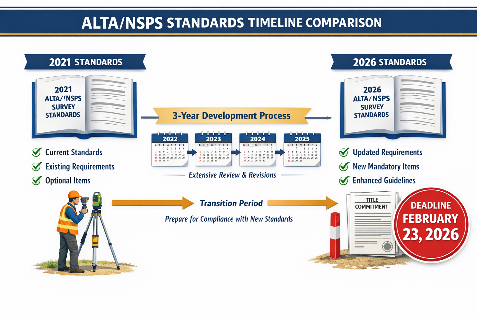
The 2026 ALTA/NSPS Land Title Survey Updates: What Surveyors Must Know Before the February Deadline didn't emerge overnight. The Joint ALTA/NSPS Work Group, under the leadership of Todd D'Amico, PS of Oklahoma, invested over three years developing these comprehensive standards before their formal adoption in October 2025[2]. This deliberate, methodical approach reflects the complexity of balancing surveyor capabilities with title insurance requirements.
The Work Group's composition deserves attention—it comprises roughly equal numbers of professional surveyors and title professionals who meet semi-annually[2]. This balanced representation ensures that the standards serve both communities effectively, addressing real-world challenges faced in commercial real estate transactions. The collaborative nature of this development process distinguishes these standards from top-down regulatory mandates, creating buy-in across the industry.
Critical Effective Date: February 23, 2026
The February 23, 2026 deadline functions as a hard cutoff for compliance. Contracts executed on or after this date must adhere to the 2026 standards without exception[2]. This creates a clear dividing line in the industry, though it also introduces some transitional complexity that surveyors must navigate carefully.
Importantly, surveys contracted before February 23, 2026, may continue under the 2021 standards[2]. This provision provides some flexibility for transactions already in progress, preventing disruption to deals nearing completion. However, there are limited exceptions for delayed closings anticipated to complete shortly after the transition date[2], creating a gray area that requires careful contract language and client communication.
For professionals managing multiple projects simultaneously, tracking which standard applies to each survey becomes a critical administrative function. Building survey professionals must implement systems to ensure compliance with the correct standard version for each engagement.
Primary Focus Areas of the 2026 Updates
The 2026 standards emphasize four core improvement areas that pervade the entire document[3]:
1. Clearer Documentation Requirements 📋
Ambiguity has long plagued survey deliverables, with different professionals interpreting requirements differently. The 2026 standards address this through more explicit language about what must be shown, how it should be documented, and when explanatory notes are required.
2. Enhanced Transparency
Transparency between surveyors, title professionals, and clients receives significant attention. The new standards require surveyors to explain their methodologies, document their sources, and clarify relationships between survey findings and record information.
3. Improved Communication Protocols
Communication breakdowns have historically caused delays and disputes in real estate transactions. The 2026 standards establish clearer expectations for information exchange, particularly regarding title commitments and client requirements.
4. Refined Precision Requirements
While maintaining professional judgment, the new standards provide better guidance on acceptable precision levels and documentation of surveying methods, helping to standardize quality across the profession.
These focus areas reflect feedback from thousands of transactions where unclear standards created confusion, delays, or disputes. For property owners and professionals involved in commercial real estate, these improvements should streamline transactions and reduce misunderstandings.
Key Changes in the 2026 ALTA/NSPS Land Title Survey Updates You Cannot Ignore
The Title Commitment Requirement Revolution
Perhaps the most significant operational change in the 2026 ALTA/NSPS Land Title Survey Updates: What Surveyors Must Know Before the February Deadline involves title commitments. Surveyors must now be provided with the most recent title commitment or other title evidence satisfactory to the insurer[2][5]. This requirement, invoked by wording in Section 4, fundamentally alters the information flow in survey transactions.
Previously, surveyors often worked without complete title information, creating potential gaps between what the survey showed and what title issues existed. The new requirement ensures surveyors have access to:
- Abstracts of title providing historical ownership information
- Title opinions from qualified attorneys
- Old title policies from previous transactions
- Current title commitments showing proposed insurance coverage
This change places new responsibilities on clients and title companies to provide documentation promptly. Surveyors should establish clear protocols for requesting, receiving, and reviewing this information before fieldwork begins. The requirement also creates potential liability issues if surveyors proceed without adequate title evidence.
Redefining "Updates": A Paradigm Shift
The 2026 standards make an unambiguous declaration: there is no such thing as an "update"[2]. This statement challenges common industry practice and requires careful explanation to clients accustomed to requesting survey updates at reduced fees.
The reality under the new standards is straightforward—any survey with a new certification date is technically a new survey[2]. The surveyor certifies that the survey reflects current conditions and meets all current standards requirements. This certification carries full professional liability regardless of whether the surveyor relied on previous work.
However, this doesn't eliminate pricing flexibility or efficiency gains from previous surveys. Surveyors may still offer:
- Reduced fees based on prior survey work that remains valid
- Faster turnaround times when existing data can be verified and incorporated
- Focused fieldwork concentrating on changes since the previous survey
The critical distinction is that the certification is new and complete, even if the underlying work leverages previous efforts. This protects both surveyors and clients by ensuring current standards compliance while acknowledging practical efficiencies.
For clients, this means understanding that requesting an "update" actually means commissioning a new survey that may cost less due to available prior work. Clear communication about this distinction prevents misunderstandings about scope and liability.
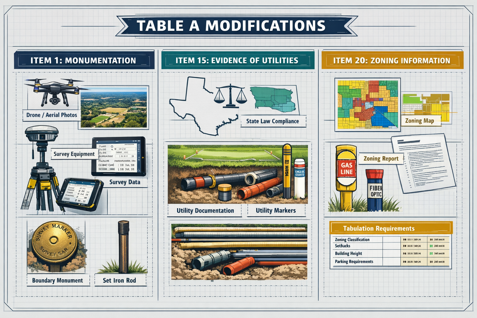
Mandatory Utility Evidence: From Optional to Required
What was previously Table A Item 11(a) regarding evidence of utilities has been elevated to mandatory status as part of all ALTA/NSPS Land Title Surveys[5]. This change eliminates prior ambiguity between optional items and standard requirements, ensuring consistent utility documentation across all surveys.
Surveyors must now investigate and document:
- Visible utility infrastructure on or serving the property
- Evidence of utility services from available records
- Underground utility locations to the extent reasonably determinable
- Utility easements and their relationship to physical improvements
This requirement recognizes the critical importance of utility information in real estate transactions. Lenders and buyers need to understand what services are available, where infrastructure is located, and whether improvements conflict with utility easements. Making this mandatory ensures no survey omits this essential information.
The practical impact for surveyors includes additional research time, potential utility locate requests, and more detailed documentation on survey plats. Building survey professionals should factor these requirements into project timelines and fee structures.
Table A Modifications: Three Critical Changes Surveyors Must Implement
Item 1: State Law Requirements Override Optional Status
Table A Item 1 received an important clarification reminding all parties that state law requirements override the optional status of Table A items[2]. This addresses a persistent source of confusion where surveyors treated all Table A items as truly optional, even when state regulations mandated certain activities.
For example, many states require boundary monumenting as part of any survey establishing or reestablishing property corners. Even if Table A Item 1 isn't specifically requested by the client, state law may mandate this work. The 2026 standards clarify that surveyors must comply with applicable state regulations regardless of Table A selections.
This creates several practical implications:
For Surveyors:
- Review state-specific requirements for every jurisdiction where you practice
- Educate clients about mandatory items that cannot be waived
- Include state law compliance in standard fee structures
- Document state requirements in survey notes when applicable
For Clients:
- Understand that some items may be required by law, not optional
- Budget for mandatory state requirements beyond basic ALTA standards
- Consult with local surveyors about jurisdiction-specific needs
For Title Professionals:
- Recognize that survey scope may exceed Table A selections due to state law
- Coordinate with surveyors to understand applicable requirements
- Ensure title commitments reflect state-mandated survey elements
This clarification protects surveyors from liability when performing legally required work that clients might not have specifically requested. It also ensures consistency in survey deliverables across different jurisdictions.
Item 15: Imagery-Based Documentation Returns
Table A Item 15 underwent significant revision, reverting to its original intent of allowing imagery-based documentation of features not in close proximity to boundaries or relevant setlines[2]. This change acknowledges technological advances while maintaining quality standards for critical survey elements.
Under the revised Item 15, surveyors may use aerial photography, drone imagery, or other photographic documentation for certain features, provided they obtain written agreement from:
- The client commissioning the survey
- The lender financing the transaction
- The title insurer providing coverage
This three-party approval requirement ensures all stakeholders understand and accept imagery-based documentation for specific survey elements. The approach balances efficiency with precision, allowing modern technology where appropriate while maintaining traditional surveying methods for critical measurements.
Appropriate Uses for Imagery-Based Documentation:
- Remote building features far from property boundaries
- Landscape elements not affecting setback compliance
- Parking areas and paving distant from lot lines
- Topographic features in interior portions of large parcels
Situations Requiring Traditional Surveying:
- Buildings near property boundaries
- Improvements affecting setback requirements
- Encroachments or potential boundary disputes
- Easement compliance verification
For chartered surveyors adopting drone technology and photogrammetry, this provision provides clear guidance on appropriate applications while protecting professional standards. The written agreement requirement creates a documented record of methodology decisions.
Item 20: New Tabulation Requirements
Table A Item 20 introduces an entirely new requirement for surveyors to tabulate documentation already required under Sections 5 and 6[2]. While this doesn't create new fieldwork or research obligations, it does require surveyors to organize and present information in tabular format, providing clients with analytical benefits beyond basic survey delivery.
The tabulation requirement recognizes that raw survey data, even when complete and accurate, may not be easily digestible for clients, lenders, or title professionals unfamiliar with survey conventions. By requiring organized tables, the standards ensure information is accessible and useful for decision-making.
Typical Tabulation Elements:
| Category | Information Required | Purpose |
|---|---|---|
| Easements | Type, beneficiary, recording information, location | Quick reference for title review |
| Encroachments | Description, dimension, affected party | Identify potential title issues |
| Setbacks | Required vs. actual, compliance status | Zoning verification |
| Areas | Parcel size, building footprint, coverage | Development analysis |
| Utilities | Type, location, serving status | Infrastructure assessment |
This organizational requirement adds value for clients while requiring minimal additional effort from surveyors who have already gathered the underlying information. The tabulation serves as an executive summary of critical survey findings, making the survey more accessible to non-technical stakeholders.
For surveyors, implementing standardized tabulation templates streamlines this requirement and ensures consistency across projects. Many survey software packages now include tabulation features specifically designed for ALTA/NSPS compliance.
Documentation and Communication Requirements Under the 2026 Standards
Explaining Modifications on the Plat Face
Section 6.D.ii.(g) now requires that any modifications to standard procedures must be explained in notes on the face of the plat or map[2]. This transparency requirement ensures that anyone reviewing the survey understands exactly what methods were used and where departures from standard practice occurred.
This provision addresses situations where surveyors must adapt standard methodologies due to site conditions, access limitations, or client requirements. Rather than leaving these adaptations undocumented or buried in separate reports, the 2026 standards require clear, prominent disclosure on the survey itself.
Examples of Modifications Requiring Explanation:
- Use of remote sensing instead of direct measurement for inaccessible areas
- Reliance on record dimensions where physical evidence is unavailable
- Acceptance of client-provided data for specific elements
- Limitations on research due to record availability
The notes should be specific, explaining both what modification was made and why it was necessary. This protects surveyors from liability while ensuring clients understand any limitations in the survey deliverable.
New Description Relationships
When surveyors create new descriptions based on survey results, the 2026 standards now require notes explaining how they relate to record descriptions[5]. This requirement addresses a common source of confusion in real estate transactions where survey-based descriptions differ from deed descriptions.
The relationship note should clarify:
- Whether the new description supersedes the record description
- How the new description resolves ambiguities in the record
- What differences exist between surveyed and recorded dimensions
- Whether boundary discrepancies were discovered and resolved
This documentation is particularly critical when survey findings reveal errors in record descriptions or when monuments found in the field don't match recorded positions. Clear explanation prevents title issues and helps attorneys draft appropriate deed language for transactions.
For property professionals involved in complex boundary situations, these explanatory notes provide essential context for understanding survey findings and their implications for title insurance.
Enhanced Client Communication Protocols
The 2026 standards place greater emphasis on proactive communication between surveyors and all transaction parties. This reflects recognition that many survey-related problems stem from miscommunication or unclear expectations rather than technical deficiencies.
Key Communication Points:
📞 Pre-Survey Consultation
- Discuss client objectives and specific concerns
- Clarify Table A item selections and implications
- Establish timeline expectations and potential delays
- Review title commitment and identify survey-relevant issues
📧 During Survey Execution
- Notify clients of unexpected findings immediately
- Discuss potential encroachments or boundary issues as discovered
- Coordinate access requirements and site conditions
- Update timeline if complications arise
📋 Delivery and Explanation
- Provide clear explanation of survey findings
- Highlight critical issues affecting the transaction
- Answer questions about methodology and limitations
- Offer to participate in closing discussions if needed
This enhanced communication framework prevents surprises at closing and ensures all parties understand survey implications for their transaction. For surveyors, documenting these communications protects against claims that important information wasn't conveyed.
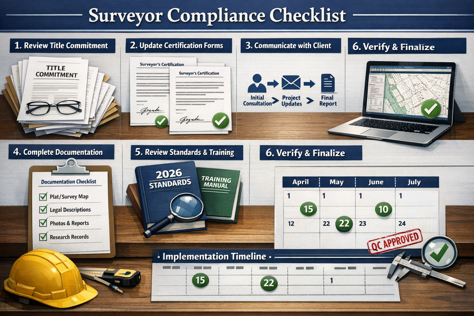
Compliance Checklist: Preparing for the 2026 ALTA/NSPS Land Title Survey Updates Before the February Deadline
Immediate Action Items (Complete Before February 23, 2026)
✅ Review and Update Standard Contracts
- Incorporate 2026 standards references
- Add title commitment requirement language
- Clarify "update" terminology and pricing
- Include state law compliance provisions
- Update Table A item descriptions
✅ Establish Title Evidence Protocols
- Create title commitment request templates
- Develop tracking systems for title document receipt
- Train staff on reviewing title commitments
- Establish procedures for incomplete title evidence
✅ Revise Survey Templates and Forms
- Update plat/map formats for new requirements
- Create tabulation templates for Table A Item 20
- Add modification explanation note sections
- Include relationship notes for new descriptions
- Ensure utility evidence documentation areas
✅ Train Staff and Field Crews
- Conduct comprehensive training on 2026 changes
- Review state-specific mandatory requirements
- Practice new documentation procedures
- Test revised templates on sample projects
- Establish quality control checkpoints
✅ Update Fee Structures
- Account for title commitment review time
- Include tabulation preparation in standard fees
- Adjust "update" pricing and terminology
- Factor in enhanced documentation requirements
- Consider state law compliance costs
Client Education and Communication
The transition to the 2026 standards requires proactive client education to prevent misunderstandings and manage expectations. Many clients remain unaware of the changes and their implications for survey costs, timelines, and deliverables.
Key Messages for Clients:
🔔 Timeline Impact
"The new standards require additional documentation and review time. Please allow extra time for survey completion, particularly for title commitment review and tabulation preparation."
💰 Cost Considerations
"Enhanced requirements may affect survey costs. However, the improved documentation provides greater value and reduces transaction risks."
📄 Deliverable Changes
"You'll receive more comprehensive documentation, including organized tables of critical information and clearer explanations of survey findings."
🔄 "Update" Clarification
"Under the 2026 standards, all surveys with new certifications are new surveys meeting current requirements. We can still offer efficiencies based on prior work, but the certification is complete and current."
For building survey professionals working with property owners, clear communication about these changes builds trust and prevents fee disputes.
Technology and Software Updates
Many surveyors rely on specialized software for survey preparation, CAD drafting, and report generation. These systems require updates to accommodate 2026 standard requirements.
Software Considerations:
CAD and Drafting Systems:
- Update title block templates with 2026 standard references
- Create layer structures for new documentation requirements
- Develop tabulation blocks and formatting
- Add note templates for modifications and relationships
Survey Data Management:
- Incorporate title commitment tracking
- Add fields for state law compliance documentation
- Create workflows for imagery-based documentation approvals
- Implement quality control checklists for 2026 requirements
Client Portal and Delivery Systems:
- Update client communications with 2026 information
- Revise proposal templates and fee structures
- Modify delivery formats for enhanced documentation
- Create educational materials about standard changes
Surveyors should work with software vendors to ensure systems support 2026 compliance. Many vendors have released updates specifically addressing the new standards, and early adoption prevents last-minute scrambling as the deadline approaches.
Quality Control and Internal Review Processes
The enhanced documentation and transparency requirements in the 2026 standards necessitate more robust internal quality control processes. Surveyors should implement systematic reviews to ensure compliance before survey delivery.
Quality Control Checklist:
☑️ Title Evidence Review
- Title commitment received and reviewed
- Title issues identified and addressed in survey
- Easements shown match title commitment
- Record owners verified against title documents
☑️ Documentation Completeness
- All required notes included on plat face
- Modifications explained clearly
- New description relationships documented
- State law compliance verified
☑️ Table A Compliance
- Requested items completed fully
- State-mandated items included regardless of request
- Imagery-based documentation approvals obtained
- Tabulation requirements met (if Item 20 selected)
☑️ Utility Evidence
- Mandatory utility investigation completed
- Visible utilities documented
- Utility records researched
- Easement relationships shown
☑️ Communication Documentation
- Client consultations documented
- Significant findings communicated promptly
- Delivery explanation provided
- Questions and responses recorded
Implementing these quality control measures before the February deadline allows surveyors to identify and address compliance gaps while there's still time for corrections.
Impact on Real Estate Transactions and Stakeholder Responsibilities
Implications for Lenders and Title Companies
The 2026 ALTA/NSPS Land Title Survey Updates: What Surveyors Must Know Before the February Deadline creates new responsibilities for lenders and title companies beyond simply ordering surveys. These stakeholders must adapt their processes to support surveyor compliance with the new standards.
Title Company Responsibilities:
📑 Timely Title Commitment Delivery
Title companies must provide title commitments or other acceptable title evidence to surveyors promptly. Delays in title document delivery now directly impact survey timelines, as surveyors cannot proceed without this required information[2][5].
🔍 Survey Review Procedures
Title professionals should familiarize themselves with 2026 standard changes to effectively review survey deliverables. Understanding new documentation requirements helps identify complete versus deficient surveys.
💬 Surveyor Coordination
Enhanced communication between title companies and surveyors prevents issues. Title professionals should discuss survey findings that affect title commitments and coordinate resolution of discrepancies.
Lender Responsibilities:
✅ Table A Item Selection
Lenders must make informed decisions about Table A item selections, understanding that some items may be state-mandated regardless of selection. Clear communication with surveyors about requirements prevents gaps in coverage.
⏰ Timeline Adjustments
Loan closing timelines should account for enhanced survey requirements. Lenders may need to extend survey delivery deadlines to accommodate title commitment review and additional documentation.
💵 Fee Expectations
Lenders should anticipate potential fee adjustments reflecting enhanced requirements. Understanding the value of improved documentation helps justify costs to borrowers.
For professionals coordinating complex commercial transactions, these adjusted responsibilities require updated workflows and clear communication protocols among all parties.
Changes for Property Buyers and Developers
Property buyers and developers commissioning surveys under the 2026 standards will notice several differences in the survey process and deliverables.
Enhanced Information Access:
Buyers receive more comprehensive documentation, including organized tables of critical information that make survey findings more accessible. This improved presentation helps non-technical buyers understand property conditions and potential issues.
Clearer Limitation Disclosure:
The requirement to explain modifications and methodology ensures buyers understand any limitations in survey coverage. This transparency helps buyers make informed decisions about property acquisition risks.
Improved Title Integration:
The mandatory title commitment requirement means surveys better integrate with title insurance, reducing gaps between surveyed conditions and insured title. This coordination protects buyers from unexpected title issues.
Timeline Considerations:
Buyers should allow additional time for survey completion, particularly for complex properties or transactions with title complications. Rushing surveys under the new standards may compromise quality or create compliance issues.
For property owners evaluating potential purchases, understanding these changes helps set realistic expectations for the survey process and deliverable quality.
Professional Liability and Risk Management
The 2026 standards create both opportunities and challenges for professional liability and risk management. While enhanced documentation and transparency reduce some risks, new requirements create potential exposure if not properly implemented.
Risk Reduction Benefits:
✓ Clearer Standards: More explicit requirements reduce ambiguity about surveyor obligations, making it easier to demonstrate compliance with professional standards.
✓ Better Documentation: Enhanced documentation requirements create better records of surveyor methodology and findings, supporting defense against claims.
✓ Improved Communication: Required communication protocols ensure clients receive and understand critical information, reducing claims based on alleged non-disclosure.
New Risk Areas:
⚠️ Title Commitment Reliance: Surveyors now rely on title commitments for survey scope, creating potential liability if title information is incomplete or inaccurate.
⚠️ Tabulation Accuracy: New tabulation requirements create additional opportunities for errors in data organization and presentation.
⚠️ State Law Compliance: Clarification that state law overrides Table A selections increases liability for failing to perform state-mandated work.
Surveyors should review professional liability insurance coverage to ensure policies adequately address 2026 standard requirements. Many insurers offer risk management resources specifically addressing ALTA/NSPS survey compliance.
Frequently Asked Questions About the 2026 ALTA/NSPS Updates
What happens if I sign a contract before February 23, 2026, but the survey isn't completed until after?
Contracts executed before February 23, 2026, may continue under the 2021 standards, even if the survey is completed after the deadline[2]. However, there are limited exceptions for delayed closings, so surveyors should clarify which standard applies in the contract language. The key date is contract execution, not survey completion or transaction closing.
Can I still offer reduced fees for survey "updates" under the 2026 standards?
Yes, but terminology matters. While there's no such thing as an "update" under the 2026 standards, surveyors can still offer reduced fees or faster turnaround based on prior survey work[2]. The critical distinction is that any survey with a new certification date is a complete new survey meeting current standards. Pricing flexibility reflects efficiency gains from existing data, not a reduced scope of certification.
What if my client doesn't provide a title commitment?
The 2026 standards require surveyors to receive the most recent title commitment or other title evidence satisfactory to the insurer[2][5]. If the client cannot or will not provide this documentation, surveyors should not proceed with the survey. The contract should clearly state that title evidence is a prerequisite for survey commencement, and surveyors should document any delays caused by missing title information.
Do all Table A items become mandatory under the 2026 standards?
No, Table A items remain optional selections except where state law mandates specific activities[2]. Additionally, what was previously Table A Item 11(a) regarding utility evidence is now mandatory for all surveys[5]. Surveyors must understand applicable state requirements and perform legally mandated work regardless of Table A selections.
How do I obtain written agreement for imagery-based documentation under Item 15?
Table A Item 15 requires written agreement from the client, lender, and title insurer before using imagery-based documentation[2]. Surveyors should create a standard form documenting this three-party approval, specifying exactly which features will be documented through imagery and confirming all parties understand and accept this methodology. This agreement should be obtained before fieldwork begins and retained in project files.
What software updates do I need for 2026 compliance?
Most survey software vendors have released updates supporting 2026 standards. Surveyors should contact their software providers about available updates for CAD systems, data management platforms, and report generation tools. Updates typically include revised templates, new documentation fields, and quality control checklists aligned with 2026 requirements.
Conclusion: Ensuring Seamless Transition to the 2026 Standards
The 2026 ALTA/NSPS Land Title Survey Updates: What Surveyors Must Know Before the February Deadline represents a significant evolution in land surveying standards, reflecting the profession's commitment to clarity, transparency, and quality. While the changes require substantial preparation and adaptation, they ultimately strengthen the surveying profession and improve outcomes for all real estate transaction stakeholders.
The February 23, 2026 deadline is not merely an administrative milestone—it's a watershed moment that will define surveying practice for years to come. Surveyors who approach this transition proactively, implementing necessary changes to contracts, templates, workflows, and communication protocols, will navigate the deadline smoothly while positioning themselves as industry leaders.
The enhanced requirements around title commitments, documentation, tabulation, and transparency create more work in the short term but deliver substantial long-term benefits. Clients receive more comprehensive, accessible information. Title professionals gain better integration between surveys and title insurance. Lenders obtain clearer documentation of property conditions. And surveyors benefit from reduced ambiguity and stronger professional standards.
Actionable Next Steps
For Surveyors:
- Complete immediate action items from the compliance checklist before February 23, 2026
- Schedule comprehensive staff training on all 2026 standard changes
- Update all templates, contracts, and forms to reflect new requirements
- Establish title commitment protocols for requesting and reviewing title evidence
- Test revised processes on sample projects before the deadline
- Review professional liability insurance to ensure adequate coverage
- Create client education materials explaining standard changes and implications
For Title Professionals:
- Develop efficient title commitment delivery processes to support surveyor requirements
- Train staff on 2026 standard changes to improve survey review capabilities
- Establish surveyor communication protocols for addressing title-survey discrepancies
- Update closing timelines to account for enhanced survey requirements
For Lenders and Buyers:
- Allow additional time for survey completion under new standards
- Budget appropriately for potential fee adjustments reflecting enhanced requirements
- Communicate clearly with surveyors about specific transaction needs
- Review deliverables carefully to leverage improved documentation and tabulation
The surveying profession has successfully navigated previous standard updates, and the 2026 transition will be no different. By understanding the changes, preparing systematically, and communicating effectively with all stakeholders, surveyors can ensure compliance while delivering superior value to clients.
For chartered surveyors and property professionals committed to excellence, the 2026 standards represent an opportunity to elevate practice standards and strengthen the profession's role in real estate transactions. The deadline approaches rapidly—the time for preparation is now.
References
[1] 20260126 Alta Insights Understanding The 2026 Altansps Land Title Survey Standards – https://www.alta.org/news-and-publications/news/20260126-ALTA-Insights-Understanding-the-2026-ALTANSPS-Land-Title-Survey-Standards
[2] The 2026 Minimum Standard Detail Requirements For Alta Nsps Land Title Surveys – https://amerisurv.com/2026/02/01/the-2026-minimum-standard-detail-requirements-for-alta-nsps-land-title-surveys/
[3] New 2026 Minimum Standard Detail 3684174 – https://www.jdsupra.com/legalnews/new-2026-minimum-standard-detail-3684174/
[4] 2026 Alta Nsps Land Title Survey Standards – https://www.partneresi.com/resources/references/standards-regulations/2026-alta-nsps-land-title-survey-standards/
[5] nsps.us – https://nsps.us.com/?page=ALTANSPSFAQs
[6] Alta Standards Updated – https://cretelligent.com/alta-standards-updated/