The landscape of property surveying has undergone a dramatic transformation. Gone are the days when surveyors relied solely on theodolites, measuring chains, and hand-drawn maps to understand land boundaries and characteristics. In 2026, Geographic Information Systems (GIS) have become the cornerstone of modern surveying practice, enabling professionals to make smarter, data-driven land use decisions with unprecedented accuracy and efficiency. GIS Integration for Property Surveyors: Overlaying Data for Smarter Land Use Decisions in 2026 represents not just a technological advancement, but a fundamental shift in how surveyors approach their work—centralizing zoning regulations, property boundaries, utility locations, and environmental data into powerful visual platforms that reveal patterns invisible to traditional methods.
This comprehensive guide explores how property surveyors can harness GIS technology to transform raw data into actionable intelligence, streamline development projects, and deliver exceptional value to clients navigating increasingly complex regulatory landscapes.
Key Takeaways
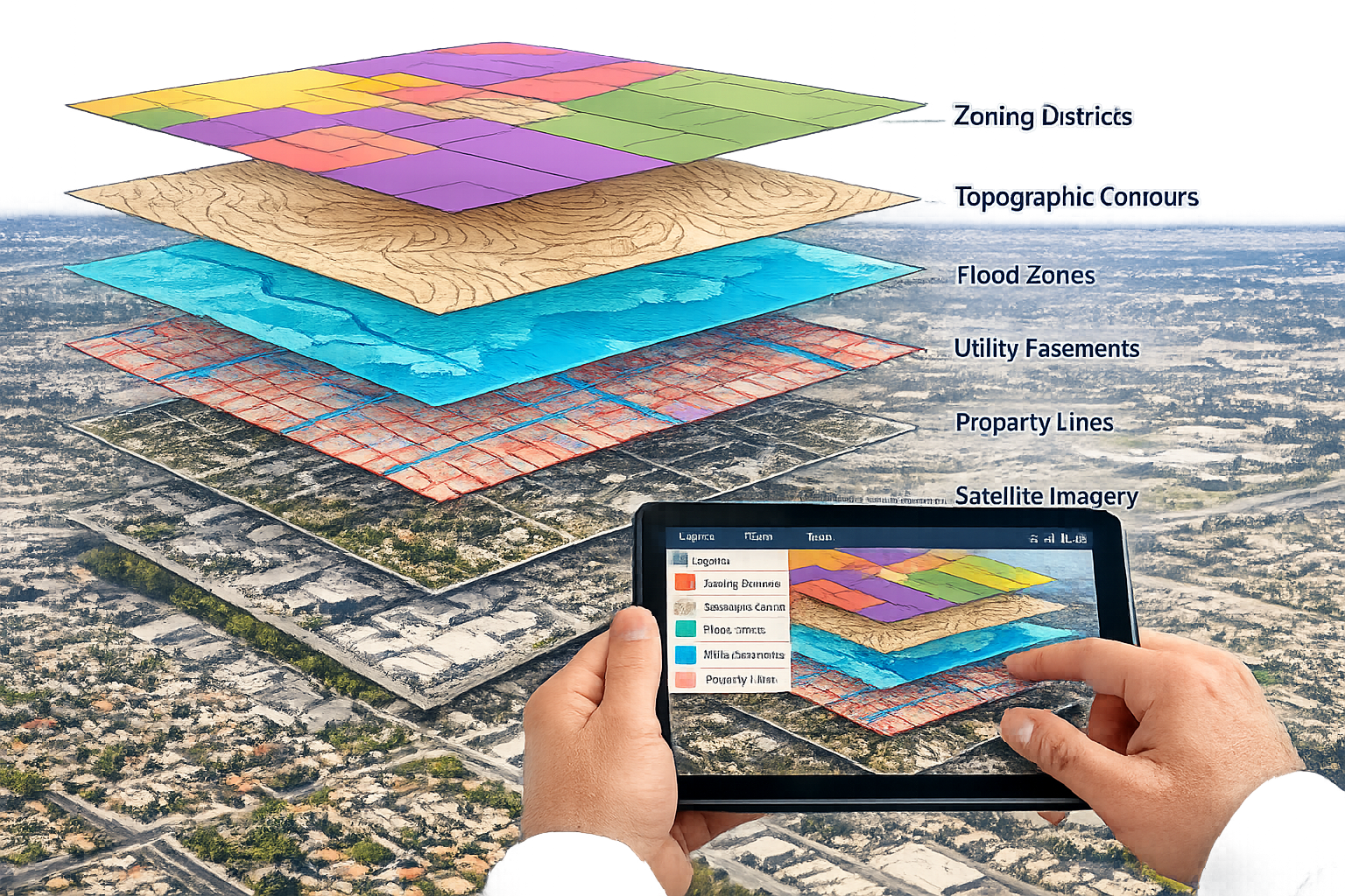
- Multi-layer visualization enables surveyors to overlay property boundaries, utilities, zoning, flood zones, and topographic data on a single interactive map, revealing critical relationships and potential conflicts before fieldwork begins[3][4]
- Pre-survey data accessibility through GIS platforms reduces fieldwork time and costs by identifying problem areas, utility locations, and existing survey data in advance[4]
- Interactive dashboards allow real-time data editing, custom map generation, and collaborative decision-making across development teams[4]
- Risk assessment capabilities help predict long-term challenges like flood impacts and construction constraints, supporting proactive planning strategies[4]
- 2026 ALTA/NSPS standards emphasize clarity, transparency, and accuracy in survey reporting, making GIS integration even more valuable for meeting compliance requirements[1]
Understanding GIS Integration for Property Surveyors in 2026
What is GIS Integration?
Geographic Information Systems (GIS) represent sophisticated software platforms that capture, store, analyze, and display geographically referenced data. For property surveyors, GIS integration means bringing together diverse data sources—from government zoning databases to utility company records, from topographic surveys to environmental assessments—into a unified spatial framework.
Think of GIS as a digital filing cabinet where every piece of information has a specific location on Earth. When surveyors integrate multiple data layers, they create a comprehensive picture that shows not just where property lines exist, but how they interact with underground utilities, drainage patterns, regulatory restrictions, and development opportunities.
The Evolution from Traditional to Digital Surveying
The property development landscape in 2026 has transformed significantly. Surveyors no longer depend exclusively on traditional measurement methods[6]. While field measurements remain essential for accuracy verification, the preliminary analysis, planning, and risk assessment phases now occur primarily in digital environments.
This evolution offers several advantages:
- Reduced field time through better preparation
- Enhanced accuracy by cross-referencing multiple data sources
- Improved client communication with visual presentations
- Faster project turnaround from data collection to deliverables
- Better risk identification before expensive fieldwork begins
Modern surveyors who embrace building survey methodologies increasingly rely on GIS to supplement traditional techniques, creating hybrid workflows that maximize both efficiency and precision.
Core Components of GIS Integration for Property Surveyors: Overlaying Data for Smarter Land Use Decisions in 2026
Essential Data Layers for Land Use Analysis
Successful GIS integration depends on identifying and acquiring the right data layers. For property surveyors focused on land use decisions, these typically include:
Boundary and Ownership Data:
- Property boundaries and lot lines
- Easements and rights-of-way
- Historical boundary surveys
- Title information and ownership records
Regulatory and Zoning Information:
- Current zoning classifications
- Overlay districts and special restrictions
- Setback requirements
- Height limitations
- Permitted use categories
Infrastructure and Utilities:
- Water and sewer line locations
- Electrical transmission corridors
- Gas pipeline routes
- Telecommunications infrastructure
- Stormwater management systems
Environmental and Physical Features:
- Topographic contours and elevation data
- Flood zones and floodplain boundaries
- Wetlands and protected habitats
- Soil types and geological characteristics
- Watershed boundaries
Development Context:
- Recent comparable sales data
- Existing structures and improvements
- Transportation networks
- Demographic information
- Future development plans
When conducting property valuations, understanding how these layers interact provides critical context that influences market value and development potential.
Multi-Layer Data Integration Techniques
The true power of GIS emerges when surveyors overlay multiple data types simultaneously. This multi-layer integration allows professionals to visualize complex relationships and identify issues that would remain hidden when examining data sources separately[3].
For example, overlaying property boundaries with flood zone data immediately reveals which portions of a parcel face development restrictions. Adding utility easements to this view shows where infrastructure constraints might limit building placement. Incorporating zoning regulations completes the picture, defining exactly what development scenarios remain viable.
| Data Layer Combination | Insights Revealed | Practical Application |
|---|---|---|
| Boundaries + Utilities | Easement conflicts | Identify areas requiring utility relocation |
| Topography + Drainage | Water flow patterns | Design grading plans and stormwater management |
| Zoning + Flood Zones | Developable area | Calculate maximum building envelope |
| Sales Data + Demographics | Market trends | Support valuation and feasibility studies |
| Environmental + Regulatory | Protected areas | Identify permitting requirements early |
This layered approach transforms surveying from a measurement exercise into a strategic planning tool that guides smarter development decisions.
Interactive Dashboards and Custom Mapping
Modern GIS systems in 2026 support sophisticated interactive dashboards that revolutionize how surveyors work with spatial data[4]. These platforms allow users to:
✅ Generate custom maps tailored to specific project requirements
✅ Edit datasets in real-time as new information becomes available
✅ Upload new information from field surveys or client sources
✅ Filter and query data based on multiple criteria
✅ Share visualizations with stakeholders for collaborative review
✅ Export reports in various formats for different audiences
Interactive dashboards eliminate the rigid, static maps of previous decades. Instead, surveyors can adjust visualizations on the fly during client meetings, testing different development scenarios and immediately seeing how changes affect regulatory compliance, infrastructure requirements, or environmental impacts.
This flexibility proves especially valuable when working on planning applications where multiple stakeholders need to understand complex spatial relationships.
Practical Applications: GIS Integration for Property Surveyors Overlaying Data for Smarter Land Use Decisions in 2026
Pre-Survey Planning and Data Accessibility
One of the most significant advantages of GIS integration involves pre-survey data accessibility. Before surveyors even visit a site, GIS platforms provide comprehensive information about the property and its context[4].
This pre-survey intelligence includes:
Existing Survey Data:
Access to previous surveys conducted in the area helps surveyors understand historical boundary determinations, identify potential discrepancies, and plan verification measurements more efficiently.
Utility Locations:
Knowing where underground utilities exist before fieldwork begins prevents costly damage during survey operations and helps plan safe working procedures. This information also supports building defects surveys by identifying infrastructure that might affect property conditions.
Topographic Context:
Understanding terrain characteristics, elevation changes, and drainage patterns before site visits allows surveyors to bring appropriate equipment and plan efficient field procedures.
Regulatory Requirements:
Reviewing zoning restrictions, environmental constraints, and permit requirements in advance ensures surveyors collect all necessary data during initial site visits, reducing the need for return trips.
This preparation phase dramatically reduces fieldwork time and associated costs while improving the quality and completeness of survey deliverables.
Identifying Problem Areas and Data Gaps
GIS technology excels at helping surveyors identify areas requiring initial survey work or re-survey due to previous faulty data[4]. By studying area-specific topography and hydrological data, professionals can spot inconsistencies that warrant closer investigation.
Common problem indicators include:
🔍 Boundary discrepancies between adjacent parcels
🔍 Utility easements that don't align with actual infrastructure
🔍 Flood zone boundaries that conflict with observed drainage patterns
🔍 Zoning classifications inconsistent with surrounding areas
🔍 Missing data in critical locations
When these issues surface during GIS analysis rather than mid-project, surveyors can address them proactively, avoiding delays and budget overruns. This capability proves particularly valuable for Level 3 building surveys where comprehensive property assessment requires complete and accurate baseline data.
Risk Assessment and Long-Term Planning
Perhaps the most strategic application of GIS integration involves risk assessment and predictive analysis. Modern GIS platforms enable surveyors to identify long-term risks that might affect property value, development feasibility, or ongoing maintenance requirements[4].
Flood Risk Analysis:
Overlaying property boundaries with detailed flood zone maps, historical flood data, and projected climate scenarios helps surveyors assess flood vulnerability. This information proves critical for insurance requirements, development planning, and property valuations.
Construction Impact Zones:
GIS analysis can predict how proposed construction might affect neighboring properties, infrastructure systems, or environmental features. This foresight supports better planning and damage mitigation strategies.
Infrastructure Capacity:
Evaluating existing utility capacity against proposed development demands reveals potential bottlenecks before they become project-stopping problems.
Environmental Compliance:
Identifying protected habitats, wetlands, or archaeological sites early in the planning process prevents costly redesigns and regulatory violations.
These predictive capabilities transform surveyors from data collectors into strategic advisors who help clients make informed decisions about property acquisition, development timing, and investment priorities.
Implementing GIS Integration: Best Practices for Property Surveyors
Selecting the Right GIS Platform
Not all GIS systems offer the same capabilities or user experience. When selecting a platform for surveying applications, consider these factors:
Data Compatibility:
Ensure the system can import and export common surveying file formats (CAD drawings, point clouds, geodatabases) and integrate with your existing workflow tools.
Ease of Use:
Complex systems with steep learning curves reduce adoption rates among team members. Look for intuitive interfaces that balance power with accessibility.
Mobile Capabilities:
Field surveyors need access to GIS data on tablets and smartphones. Cloud-based systems with robust mobile apps enable real-time data collection and verification.
Customization Options:
The ability to create custom data layers, symbology, and reporting templates ensures the system adapts to your specific practice needs rather than forcing you to adapt to software limitations.
Integration with Other Tools:
Consider how the GIS platform connects with survey equipment, drone survey systems, project management software, and client communication platforms.
Support and Training:
Vendor support quality and available training resources significantly impact successful implementation and ongoing productivity.
Building a Comprehensive Data Library
The value of GIS integration directly correlates with the quality and completeness of your data library. Successful surveying practices invest time in building robust spatial databases that include:
Public Data Sources:
- Government zoning maps and regulations
- FEMA flood maps
- Geological survey data
- Census demographic information
- Transportation department records
Proprietary Data:
- Previous survey work completed by your firm
- Client-provided information
- Field measurements and observations
- Photographic documentation
- Historical research findings
Third-Party Data:
- Utility company infrastructure maps
- Environmental assessment reports
- Title company boundary information
- Aerial imagery and satellite data
Organize this data with consistent naming conventions, metadata standards, and quality control procedures. Regular updates ensure information remains current and reliable.
Workflow Integration and Team Training
Technology only delivers value when people use it effectively. Implementing GIS integration requires thoughtful workflow design and comprehensive team training.
Develop Standard Operating Procedures:
Document how GIS analysis fits into your surveying workflow. When does data review occur? Who performs overlay analysis? How are findings communicated to clients?
Provide Hands-On Training:
Theoretical knowledge matters less than practical skills. Give team members opportunities to work with GIS tools on real projects under supervision before expecting independent proficiency.
Start with Pilot Projects:
Rather than attempting organization-wide implementation immediately, select a few projects where GIS integration can demonstrate clear value. Use these successes to build momentum and refine processes.
Foster Continuous Learning:
GIS technology evolves rapidly. Create opportunities for ongoing education through webinars, conferences, and peer learning sessions.
Measure and Communicate Results:
Track metrics like time savings, error reduction, and client satisfaction to demonstrate GIS integration's return on investment. Share these results to maintain organizational commitment.
When team members understand how GIS tools make their work easier and more valuable, adoption becomes natural rather than forced.
Compliance and Standards: The 2026 ALTA/NSPS Framework

Understanding the 2026 ALTA/NSPS Standards
The American Land Title Association (ALTA) and National Society of Professional Surveyors (NSPS) released updated "Minimum Standard Detail Requirements for ALTA/NSPS Land Title Surveys" that took effect February 23, 2026[1]. While these standards focus primarily on survey reporting requirements rather than GIS methodology specifically, they emphasize principles that align perfectly with GIS integration benefits.
The 2026 standards prioritize:
Clarity: Survey deliverables must communicate findings unambiguously to all stakeholders, from title companies to developers to legal counsel.
Transparency: Surveyors must clearly document their methodology, data sources, and any limitations or uncertainties in their findings.
Accuracy: Measurement precision and positional accuracy must meet rigorous standards appropriate to the survey's intended use.
Communication: Effective information exchange between surveyors, clients, and other professionals ensures everyone understands property characteristics and constraints.
GIS integration naturally supports these principles by providing visual clarity, documenting data sources, enabling accuracy verification through multiple reference points, and facilitating stakeholder communication through interactive maps.
How GIS Supports Compliance
Property surveyors using GIS integration find compliance with 2026 ALTA/NSPS standards more straightforward for several reasons:
Documentation Trail:
GIS platforms automatically track data sources, modification dates, and analysis methods, creating the transparent documentation trail required by modern standards.
Visual Communication:
Complex boundary situations, easement relationships, and encroachment issues become immediately clear through well-designed GIS visualizations, meeting clarity requirements more effectively than text descriptions alone.
Accuracy Verification:
Overlaying field measurements with existing data sources helps identify discrepancies that require resolution, supporting the accuracy emphasis in current standards.
Collaborative Review:
Interactive GIS dashboards facilitate communication between surveyors and stakeholders, ensuring everyone understands findings before final deliverables are issued.
When conducting statutory considerations as part of comprehensive property assessments, GIS integration provides the documentation framework that demonstrates regulatory compliance.
Advanced Applications and Future Trends
Integration with Emerging Technologies
GIS platforms in 2026 increasingly integrate with complementary technologies that expand surveying capabilities:
Drone and Aerial Imagery:
High-resolution aerial photography and LiDAR data captured by drones integrate seamlessly into GIS platforms, providing current visual context and precise elevation models. This combination proves especially valuable for large-site surveys and monitoring changes over time.
Building Information Modeling (BIM):
The convergence of GIS and BIM creates powerful 3D environments where surveyors can analyze how proposed structures interact with existing site conditions, utilities, and regulatory constraints.
Artificial Intelligence and Machine Learning:
AI algorithms can analyze historical survey data to predict boundary disputes, identify measurement anomalies, and suggest optimal survey point locations, making experienced surveyors even more efficient.
Internet of Things (IoT) Sensors:
Real-time monitoring of environmental conditions, infrastructure performance, and site activity provides dynamic data layers that complement traditional static survey information.
Augmented Reality (AR):
Field surveyors using AR-enabled devices can see GIS data layers overlaid on their real-world view, making it easier to locate buried utilities, verify boundaries, and communicate findings to clients on-site.
Predictive Analytics for Development Planning
Beyond describing current conditions, advanced GIS applications enable surveyors to model future scenarios and predict outcomes:
Development Impact Modeling:
Simulate how proposed construction affects traffic patterns, stormwater runoff, utility demand, and neighboring property values.
Climate Change Adaptation:
Analyze how changing precipitation patterns, sea level rise, or temperature extremes might affect long-term property viability and development strategies.
Market Trend Analysis:
Combine spatial data with economic indicators to identify emerging development opportunities and market risks.
Infrastructure Planning:
Model utility system expansion requirements to support proposed development, identifying capacity constraints before they become problems.
These predictive capabilities position surveyors as strategic advisors who help clients anticipate challenges and opportunities that traditional surveying methods would miss.
Case Studies: GIS Integration Success Stories
Urban Infill Development Project
A property developer acquired a complex urban parcel with multiple existing structures, underground utilities, and unclear boundary determinations. Traditional surveying would have required extensive fieldwork before even determining development feasibility.
GIS Integration Approach:
The surveying team began by overlaying available data layers:
- Historical surveys from adjacent properties
- City utility maps showing water, sewer, and electrical infrastructure
- Current zoning regulations and setback requirements
- Flood zone boundaries
- Recent comparable sales data
This preliminary analysis revealed several critical insights:
✅ A previously unknown utility easement crossed the optimal building location
✅ Flood zone boundaries affected only 15% of the parcel, leaving most area developable
✅ Zoning allowed increased density under recent code updates
✅ Boundary discrepancies between adjacent parcels required resolution
Armed with this information before fieldwork began, the survey team planned targeted measurements to verify critical dimensions and resolve boundary questions. The developer received a comprehensive feasibility analysis within two weeks rather than the two months traditional methods would have required.
The GIS visualization also facilitated productive discussions with city planners, utility companies, and neighboring property owners, streamlining the approval process. Similar approaches benefit professionals conducting budgeting for repairs and restoration by identifying infrastructure constraints early.
Rural Land Subdivision Analysis
A landowner sought to subdivide a 50-acre rural parcel into residential lots. Environmental regulations, topographic constraints, and infrastructure limitations created a complex planning challenge.
GIS Integration Approach:
The surveying team created a comprehensive GIS database including:
- Detailed topographic data with 1-foot contour intervals
- Wetland delineations from environmental assessments
- Soil percolation test results for septic system planning
- Road access requirements and sight distance analysis
- Utility extension cost estimates based on distance from existing infrastructure
By overlaying these layers, the team identified:
🌳 Protected wetland areas that reduced developable land by 20%
🌳 Optimal lot configurations that minimized grading costs
🌳 Access road alignments that met county standards while preserving mature trees
🌳 Septic system locations that complied with setback requirements
The GIS analysis revealed that the originally planned 15-lot subdivision wasn't economically viable, but a modified 10-lot design with larger parcels would maximize value while meeting all regulatory requirements.
This data-driven approach prevented the landowner from investing in engineering plans and permitting applications for an unfeasible design, saving over $50,000 in aborted planning costs.
Commercial Property Due Diligence
An investment firm considering a commercial property acquisition needed comprehensive due diligence within a compressed timeframe to meet contract deadlines.
GIS Integration Approach:
The surveying team assembled a due diligence GIS database containing:
- Property boundaries verified against title documents
- Easements and restrictions from title commitment
- Building footprints and parking area measurements
- ADA compliance analysis for accessibility requirements
- Zoning verification and permitted use confirmation
- Environmental site assessment findings
- Comparable sales and lease rate data
The integrated GIS presentation allowed the investment committee to visualize all critical factors simultaneously, identifying several issues that required price negotiation:
⚠️ Parking count fell short of current code requirements for the intended use
⚠️ A utility easement prevented planned building expansion
⚠️ Neighboring property development could impact access and visibility
The comprehensive GIS analysis supported informed negotiation that reduced the purchase price by $200,000 and included seller remediation of the parking deficiency. The investment firm closed the transaction confidently, understanding all material property characteristics and risks.
Overcoming Common GIS Integration Challenges
Data Quality and Consistency Issues
One of the most frequent challenges surveyors face involves inconsistent data quality across different sources. Government databases may contain outdated information, utility company records might lack precision, and historical surveys often use different coordinate systems or measurement standards.
Solutions:
Implement Quality Control Procedures:
Establish verification protocols that cross-reference multiple sources before accepting data as reliable. When discrepancies appear, prioritize the most recent, authoritative source.
Document Data Limitations:
Clearly note the vintage, source, and reliability level of each data layer. This transparency helps users understand which information requires field verification.
Invest in Data Cleanup:
Allocate time to standardize coordinate systems, correct obvious errors, and fill gaps in your data library. This upfront investment pays dividends across multiple projects.
Establish Feedback Loops:
When field surveys reveal data errors, update your GIS database and notify the original data provider. This continuous improvement approach enhances data quality over time.
Technology Adoption Resistance
Some surveying professionals, particularly those with decades of experience using traditional methods, may resist GIS integration, viewing it as unnecessary complexity or questioning its reliability.
Solutions:
Demonstrate Quick Wins:
Show skeptical team members specific examples where GIS analysis saved time, prevented errors, or identified opportunities. Concrete results overcome abstract resistance.
Respect Traditional Expertise:
Position GIS as a tool that enhances rather than replaces field surveying skills. Experienced surveyors bring judgment and knowledge that technology cannot replicate.
Provide Adequate Training:
Resistance often stems from discomfort with unfamiliar technology. Comprehensive, patient training builds confidence and competence.
Start Simple:
Don't overwhelm new users with advanced features. Begin with basic visualization and layer overlay, gradually introducing more sophisticated capabilities as comfort grows.
Cost and Resource Constraints
GIS software, data acquisition, training, and implementation require significant investment that smaller surveying practices may struggle to justify.
Solutions:
Explore Affordable Options:
Open-source GIS platforms offer robust capabilities without licensing costs. Cloud-based services provide enterprise features through affordable subscription models.
Prioritize High-Value Data:
Rather than attempting to acquire every possible data layer, focus on information that addresses your most common project types and client needs.
Leverage Public Data:
Government agencies increasingly provide free GIS data covering zoning, environmental features, infrastructure, and demographics. Maximize these resources before purchasing proprietary data.
Calculate Return on Investment:
Track time savings, error reduction, and new business opportunities attributable to GIS integration. Documenting ROI justifies continued investment and demonstrates business value.
Consider Partnerships:
Smaller firms might share GIS resources, data subscriptions, or training costs with complementary businesses, reducing individual burden while building capabilities.
Practical Tips for Maximizing GIS Value

Creating Effective Visualizations
The power of GIS lies in its ability to communicate complex spatial relationships visually. However, poorly designed maps can confuse rather than clarify.
Best Practices:
📊 Use Intuitive Symbology: Choose colors, line styles, and symbols that convey meaning naturally (blue for water features, red for boundaries, green for vegetation)
📊 Maintain Visual Hierarchy: Emphasize the most important information through size, color intensity, and placement while de-emphasizing secondary details
📊 Include Clear Legends: Never assume viewers understand your symbology choices—always provide comprehensive legends
📊 Add Context Elements: North arrows, scale bars, and reference features help viewers orient themselves and understand spatial relationships
📊 Optimize for Your Audience: Technical maps for surveyors can include more detail than presentations for non-technical stakeholders
📊 Test Readability: View your maps on different devices (desktop monitors, tablets, smartphones) to ensure critical information remains clear
When preparing visualizations for areas requiring further investigation, clarity becomes especially critical as stakeholders need to understand complex technical issues.
Maintaining Data Security and Privacy
GIS databases often contain sensitive information about property ownership, infrastructure vulnerabilities, and development plans that require protection.
Security Measures:
🔒 Implement role-based access controls limiting who can view or edit specific data layers
🔒 Use encrypted connections for cloud-based GIS platforms
🔒 Maintain regular backups stored in separate locations
🔒 Establish clear data sharing protocols that protect client confidentiality
🔒 Comply with relevant privacy regulations regarding personal information
🔒 Monitor access logs to detect unauthorized use
Balancing data accessibility for legitimate business purposes with security requirements demands thoughtful policies and technical safeguards.
Staying Current with Technology Evolution
GIS technology evolves rapidly, with new capabilities, data sources, and integration opportunities emerging constantly. Successful surveying practices commit to continuous learning and adaptation.
Strategies:
✨ Subscribe to industry publications and GIS technology newsletters
✨ Attend conferences and webinars featuring GIS applications in surveying
✨ Participate in professional organizations that share best practices
✨ Experiment with new features and tools on non-critical projects
✨ Maintain relationships with GIS vendors who can alert you to relevant developments
✨ Encourage team members to pursue GIS certifications and specialized training
Technology leadership creates competitive advantages, positioning your practice as the go-to resource for clients seeking sophisticated spatial analysis and strategic land use guidance.
The Strategic Value of GIS Integration for Property Surveyors
Competitive Differentiation
In an increasingly competitive surveying marketplace, GIS integration provides clear differentiation. Clients seeking more than basic boundary determinations gravitate toward professionals who offer strategic insights, risk assessment, and comprehensive spatial analysis.
Practices that embrace GIS Integration for Property Surveyors: Overlaying Data for Smarter Land Use Decisions in 2026 position themselves as trusted advisors rather than commodity service providers. This positioning supports premium pricing, stronger client relationships, and more interesting, complex projects.
Enhanced Client Communication
GIS visualizations transform technical survey findings into accessible information that non-technical clients can understand and act upon. Interactive maps facilitate productive conversations about development options, constraints, and opportunities.
This communication advantage proves especially valuable when working with multiple stakeholders who need to reach consensus on complex decisions. A well-designed GIS presentation can align diverse interests more effectively than traditional survey deliverables.
Risk Mitigation and Professional Liability
Comprehensive GIS analysis helps surveyors identify potential issues before they become expensive problems. This proactive approach reduces professional liability exposure while demonstrating the thoroughness that clients expect.
When surveyors can show they considered multiple data sources, verified critical information, and identified material risks, they build stronger defenses against claims of negligence or oversight. Documentation capabilities inherent in GIS platforms support this risk management objective.
Similar diligence applies when conducting building pathology assessments where comprehensive investigation and documentation prove essential.
Conclusion: Embracing the Future of Property Surveying
GIS Integration for Property Surveyors: Overlaying Data for Smarter Land Use Decisions in 2026 represents far more than technological adoption—it embodies a fundamental evolution in how surveying professionals serve clients and contribute to thoughtful development. By centralizing diverse data sources, enabling sophisticated spatial analysis, and facilitating clear communication, GIS transforms surveyors from measurement technicians into strategic advisors who guide critical land use decisions.
The surveying practices that thrive in 2026 and beyond will be those that recognize GIS integration not as an optional enhancement but as an essential capability. The benefits—reduced fieldwork time, enhanced accuracy, improved risk assessment, better client communication, and competitive differentiation—far outweigh the implementation challenges of cost, training, and workflow adaptation.
Actionable Next Steps
Ready to harness GIS integration in your surveying practice? Consider these concrete actions:
1. Assess Your Current Capabilities
Evaluate what GIS tools and data you already have access to, identify gaps in your capabilities, and prioritize areas for improvement based on your typical project types.
2. Start Small with a Pilot Project
Select an upcoming project where GIS analysis could provide clear value. Use this opportunity to experiment with tools, develop workflows, and demonstrate results without betting the entire practice on untested processes.
3. Invest in Training
Identify team members with interest and aptitude for GIS work. Provide them with quality training resources and time to develop proficiency before expecting production-level output.
4. Build Your Data Library
Begin systematically acquiring and organizing the data layers most relevant to your practice area. Focus on quality over quantity, ensuring each data source meets reliability standards.
5. Develop Standard Deliverables
Create templates for common GIS visualizations and reports that maintain consistent quality while improving efficiency. Standardization makes GIS integration sustainable rather than a custom effort for each project.
6. Communicate Value to Clients
Don't assume clients understand GIS benefits. Actively demonstrate how spatial analysis provides insights, reduces risks, and supports better decisions. Use successful projects as case studies in your marketing.
7. Stay Connected to Innovation
Join professional networks, attend industry events, and maintain relationships with technology providers who can keep you informed about emerging capabilities that might benefit your practice.
The future of property surveying belongs to professionals who combine traditional field expertise with modern analytical capabilities. GIS integration provides the foundation for this evolution, enabling surveyors to deliver unprecedented value in an increasingly complex development environment.
Whether you're assessing a single residential lot or planning a major commercial development, the ability to overlay property boundaries with zoning regulations, utilities, environmental constraints, and market data creates insights impossible to achieve through traditional methods alone. This is the promise and power of GIS Integration for Property Surveyors: Overlaying Data for Smarter Land Use Decisions in 2026—and the practices that embrace it will define the profession's future.
References
[1] Key Takeaways From The 2026 Alta Nsps 1518118 – https://www.jdsupra.com/legalnews/key-takeaways-from-the-2026-alta-nsps-1518118/
[3] How To Find Your Property Lines In Smart Methods Every Homeowner Should Know – https://www.amerisave.com/learn/how-to-find-your-property-lines-in-smart-methods-every-homeowner-should-know
[4] The Value Of Gis In Any Land Survey – https://id.land/blog/the-value-of-gis-in-any-land-survey
[6] Gis Mastery For Surveyors Enhancing Data Analysis And Decision Making In Property Development 2 – https://nottinghillsurveyors.com/blog/gis-mastery-for-surveyors-enhancing-data-analysis-and-decision-making-in-property-development-2