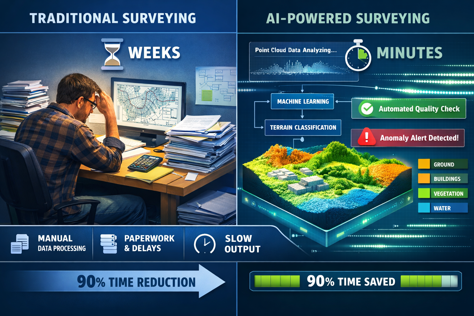
The land surveying profession stands at a pivotal transformation point in 2026. What once required weeks of manual data processing, multiple site visits, and painstaking quality checks now happens in hours—sometimes minutes. AI and Machine Learning in Land Surveying: Predicting Risks and Boosting Efficiency represents not just a technological upgrade but a fundamental reimagining of how spatial data is captured, analyzed, and transformed into actionable insights. Surveying firms that embrace these intelligent systems are discovering unprecedented capabilities: automated terrain classification, real-time anomaly detection, predictive environmental risk modeling, and compressed project timelines that would have seemed impossible just a few years ago.
The convergence of artificial intelligence with advanced sensor technologies has created a perfect storm of innovation. Drones equipped with synchronized multi-sensor arrays capture comprehensive datasets in single flights. Machine learning algorithms instantly process millions of data points, flagging inconsistencies before they reach the drafting stage. Cloud-based platforms transform static deliverables into interactive 3D digital twins that update continuously as new information arrives. For surveying professionals navigating workforce shortages and escalating client expectations, these technologies offer a pathway to deliver faster, more accurate results while maintaining the highest professional standards.
Key Takeaways
- Automated data processing powered by AI reduces post-processing timelines from weeks to hours, allowing surveyors to focus expertise on complex decision-making rather than routine data manipulation[1][3]
- Predictive risk modeling uses machine learning algorithms to forecast environmental hazards including flooding, landslides, and terrain changes by analyzing historical data patterns[2]
- Multi-sensor drone systems capture LiDAR, photogrammetry, multispectral, and thermal data simultaneously, eliminating the need for multiple site visits while achieving centimeter-level accuracy[1][2]
- Real-time quality assurance through AI-assisted checks detects inconsistencies and anomalies before projects reach drafting stages, establishing new industry quality standards[1]
- Cloud-based digital twins provide interactive 3D models that enable real-time collaboration, visualization of risk scenarios, and continuous updates as new data becomes available[1]
Understanding AI and Machine Learning in Land Surveying: Predicting Risks and Boosting Efficiency
The Digital Transformation of Surveying Workflows
The surveying profession is experiencing accelerating digital transformation driven by multiple converging pressures. Clients demand faster turnaround times without sacrificing accuracy. Workforce shortages challenge firms to accomplish more with fewer experienced professionals. Environmental complexity requires increasingly sophisticated analysis capabilities. In response, AI and machine learning technologies have moved from experimental tools to core operational systems embedded directly into surveying workflows[5].
Traditional surveying workflows followed a linear, time-intensive pattern: field data collection, manual data transfer, desktop processing, quality review, drafting, and final deliverable preparation. Each stage introduced potential delays and human error. Modern AI-powered workflows compress and parallelize these stages. Systems now instantly classify terrain, identify markers, flag anomalies, and generate preliminary surface models in real-time rather than requiring manual data processing[1]. This fundamental shift allows surveyors to spend less time on routine data manipulation and more time applying professional expertise to complex decisions that genuinely require human judgment.
The impact extends beyond simple time savings. AI-assisted quality checks add an additional safeguard layer that enhances overall surveying standards. Machine learning algorithms trained on millions of data points recognize patterns that might escape manual review, detecting subtle inconsistencies before they propagate through project workflows[1]. For firms concerned about maintaining accuracy while accelerating delivery, these automated quality assurance systems provide confidence that speed improvements don't compromise professional standards.
Core AI Technologies Transforming Surveying Practice
Several distinct AI technologies contribute to the transformation of land surveying, each addressing specific operational challenges:
Computer Vision and Image Recognition: AI systems analyze imagery from drones, satellites, and ground-based cameras to automatically identify features, classify land cover, detect changes over time, and extract measurements. These systems process visual data with consistency that surpasses manual interpretation, particularly when analyzing large datasets.
Machine Learning Classification: Algorithms learn to categorize terrain types, vegetation classes, built structures, and surface materials by training on labeled datasets. Once trained, these systems apply consistent classification criteria across entire project areas, eliminating subjective interpretation variations.
Predictive Analytics: By analyzing historical data patterns, machine learning models forecast future conditions including erosion progression, vegetation growth, flood risk zones, and infrastructure stress points. These predictive capabilities enable proactive planning rather than reactive responses[2].
Anomaly Detection: AI systems flag data points that deviate from expected patterns, identifying potential equipment errors, environmental changes, or survey markers requiring verification. This automated quality control catches issues that might otherwise remain undetected until later project stages[3].
Natural Language Processing: Emerging applications use NLP to extract relevant information from permit documents, regulations, historical reports, and project specifications, automatically flagging requirements that impact survey scope and methodology.
The Business Case for AI Adoption
Surveying firms evaluating AI implementation face legitimate questions about return on investment, implementation complexity, and operational disruption. The business case for adoption rests on several quantifiable benefits:
Dramatic Timeline Compression: Post-processing timelines have compressed dramatically, with AI-powered workflows reducing what previously took weeks down to hours or even minutes[3]. This represents one of the most significant operational improvements available to surveying firms in 2026. Faster turnaround enables firms to accept more projects with existing staff, respond to urgent client requests, and deliver preliminary findings while field crews remain on-site.
Labor Efficiency Gains: By automating routine data processing tasks, AI systems allow experienced surveyors to focus on high-value activities including client consultation, complex problem-solving, and quality assurance oversight. Firms facing workforce shortages find this efficiency multiplier particularly valuable, enabling smaller teams to maintain or expand project capacity.
Quality Consistency: Automated processing eliminates variability introduced by different technicians applying subjective judgment to classification and measurement tasks. Clients receive consistent deliverables regardless of which team members worked on their projects.
Competitive Differentiation: Early adopters gain competitive advantages through faster proposal responses, shorter project timelines, enhanced deliverable quality, and advanced capabilities including predictive risk modeling that competitors cannot match.
Scalability: AI systems scale efficiently as project complexity and data volume increase. Processing a 100-acre site versus a 1,000-acre site requires minimal additional time or labor, unlike manual workflows where processing time scales linearly with project size.
For firms considering implementation, the most successful approaches involve phased adoption starting with specific high-impact applications rather than attempting comprehensive transformation simultaneously. Many firms begin with automated data classification or quality checking, gain operational experience, then progressively expand AI integration across additional workflow stages.
How AI Automates Data Analysis and Terrain Detection
Real-Time Data Processing and Classification
The most immediate impact of AI and Machine Learning in Land Surveying: Predicting Risks and Boosting Efficiency appears in automated data processing capabilities. Modern surveying generates enormous datasets—LiDAR point clouds containing millions of individual measurements, high-resolution imagery capturing centimeter-level detail, GPS coordinates recorded at multiple points per second. Processing these datasets manually represents a significant bottleneck in traditional workflows.
AI systems embedded directly into data collection platforms now perform real-time classification and analysis as data streams from sensors[1]. A drone equipped with LiDAR and photogrammetry cameras doesn't simply record raw data for later processing. Instead, onboard or cloud-connected AI systems instantly categorize each point: ground surface, vegetation, buildings, water bodies, power lines, vehicles. This real-time classification enables several valuable capabilities:
Immediate Quality Verification: Surveyors receive instant feedback about data completeness and quality while still on-site. If the AI system detects gaps in coverage, areas with insufficient point density, or regions where classification confidence falls below acceptable thresholds, field crews can immediately recapture those areas rather than discovering deficiencies after returning to the office.
Preliminary Deliverables: Basic surface models, contour maps, and volumetric calculations become available within minutes of completing data capture. Clients receive preliminary findings the same day as field work, with detailed final deliverables following after comprehensive quality review.
Adaptive Data Capture: Advanced systems adjust collection parameters in real-time based on terrain characteristics. When flying over complex vegetation, the system automatically increases point density. When crossing uniform terrain, it optimizes for coverage efficiency. This adaptive approach ensures appropriate data quality while minimizing unnecessary collection time.
The classification accuracy of modern AI systems has reached impressive levels. Trained on diverse datasets representing various geographic regions, vegetation types, and built environments, these algorithms correctly classify 95-98% of points automatically. The remaining ambiguous points receive flagging for human review rather than incorrect automatic assignment. This combination of high-accuracy automation with targeted human oversight delivers both efficiency and reliability.
Automated Anomaly and Change Detection
Beyond initial classification, AI systems excel at identifying anomalies, defects, and changes that require attention[3]. These capabilities prove particularly valuable for several surveying applications:
Infrastructure Monitoring: Repeat surveys of roads, bridges, pipelines, and utilities benefit from automated change detection. AI systems compare current datasets against baseline surveys, automatically flagging areas where measurements deviate beyond specified tolerances. A bridge deck showing unexpected settlement, a pipeline corridor experiencing erosion, or a roadway developing surface deformation all trigger automatic alerts for detailed investigation.
Construction Progress Tracking: Projects requiring periodic verification of earthwork volumes, grading compliance, or construction progress benefit from AI-powered comparison of planned versus actual conditions. Systems automatically calculate cut/fill volumes, identify areas not meeting grade specifications, and generate visual reports highlighting discrepancies between design models and as-built conditions.
Environmental Monitoring: Long-term monitoring of coastlines, riverbanks, wetlands, and other dynamic environments relies on detecting subtle changes over time. AI systems trained to recognize erosion patterns, vegetation encroachment, sediment accumulation, and shoreline migration automatically identify and quantify these changes, providing early warning of accelerating degradation.
Asset Detection: Surveys of large properties, utility corridors, or municipal infrastructure often require cataloging existing assets including manholes, valves, markers, signs, and access points. Computer vision algorithms automatically detect and locate these features, creating comprehensive asset inventories without manual identification and digitization.
The consistency of automated anomaly detection represents a significant advantage over manual review. Human analysts reviewing large datasets experience fatigue, attention lapses, and subjective interpretation variations. AI systems apply identical criteria to every data point, ensuring that subtle anomalies receive the same scrutiny as obvious defects. This consistency proves particularly valuable for projects where regulatory compliance or liability concerns demand comprehensive documentation.
Integration with Advanced Sensor Systems
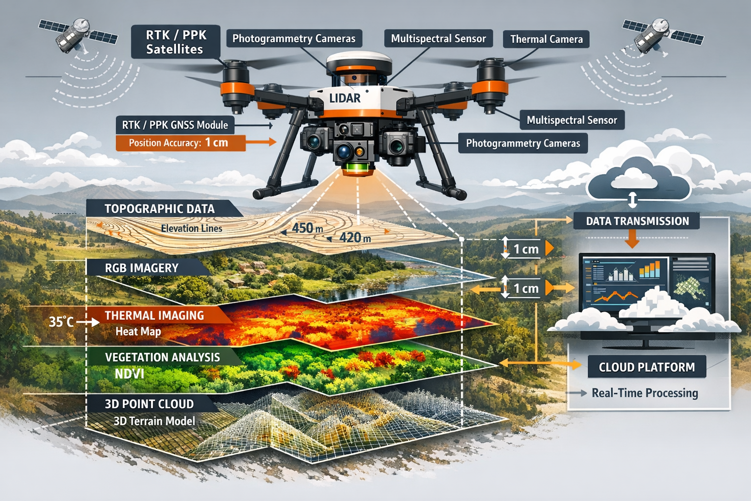
The effectiveness of AI-powered data analysis depends fundamentally on the quality and comprehensiveness of input data. The most significant advances in 2026 involve multi-sensor drone systems carrying synchronized arrays that combine LiDAR, photogrammetry cameras, multispectral sensors, and thermal imaging units working together[1]. What previously required multiple site visits with different equipment configurations now happens in a single, highly detailed flight.
These integrated sensor packages deliver complementary datasets that AI systems fuse into comprehensive terrain models:
LiDAR Point Clouds: Provide precise three-dimensional measurements of surface topography, penetrating vegetation to capture ground elevations beneath tree canopy. Modern systems achieve point densities exceeding 100 points per square meter with vertical accuracy within 2-3 centimeters.
RGB Photogrammetry: Captures high-resolution color imagery that AI systems use for feature identification, texture mapping, and visual documentation. Photogrammetric processing generates additional point clouds with color information that complements LiDAR data.
Multispectral Imaging: Records reflected light across multiple wavelength bands including near-infrared. AI analysis of multispectral data identifies vegetation health, moisture content, soil composition, and material properties invisible to conventional cameras.
Thermal Imaging: Detects temperature variations that reveal subsurface conditions, moisture infiltration, heat loss from buildings, and other thermal signatures. Combined with other datasets, thermal information helps identify underground utilities, drainage patterns, and structural defects.
The real power emerges when AI systems analyze these datasets together rather than separately. A feature that appears ambiguous in LiDAR data might be clearly identifiable in RGB imagery. Vegetation that obscures ground surface in photographs becomes transparent in LiDAR point clouds. Moisture problems invisible to conventional sensors appear clearly in thermal imaging. By fusing information from multiple sources, AI systems achieve classification accuracy and feature detection capabilities that exceed any single sensor system.
GPS and positioning systems continue evolving as well, with Global Navigation Satellite System (GNSS) implementations now providing centimeter-level accuracy real-time data[1]. UAVs equipped with high-resolution cameras and LiDAR sensors achieve even better accuracy through real-time kinematics (RTK) and post-processing kinematic (PPK) positioning, significantly improving the precision of gathered data[2]. These positioning improvements directly translate to more accurate final deliverables and greater confidence in measurements used for design, construction, and legal documentation.
For surveying firms implementing these advanced sensor systems, the initial investment in equipment represents only part of the total cost. Successful implementation requires training staff on new collection methodologies, establishing data management workflows capable of handling larger file sizes, and developing quality assurance procedures appropriate for automated processing. Firms that invest in comprehensive implementation—including equipment, training, and process development—realize the full efficiency benefits that AI and Machine Learning in Land Surveying enables.
Predicting Environmental Risks Through Machine Learning
Flood Risk Modeling and Prediction
Among the most promising applications of AI and Machine Learning in Land Surveying: Predicting Risks and Boosting Efficiency is the ability to predict devastating environmental events including flooding, landslides, and other hazards by analyzing historical data patterns[2]. While these predictive tools remain in early development stages for widespread adoption, they demonstrate significant potential for transforming how surveying professionals assess and communicate environmental risks.
Traditional flood risk assessment relies primarily on historical flood maps, regulatory floodplain designations, and hydraulic modeling based on design storm events. These approaches provide valuable baseline information but struggle with several limitations: they don't account for changing climate patterns, they may not reflect recent development that altered drainage patterns, and they typically present binary classifications (in floodplain versus out of floodplain) rather than graduated risk levels.
Machine learning flood prediction systems take a fundamentally different approach. They analyze multiple data sources simultaneously:
📊 Historical flood occurrence data including extent, depth, duration, and frequency
📊 Topographic characteristics including elevation, slope, aspect, and drainage patterns
📊 Soil properties affecting infiltration and runoff generation
📊 Land cover patterns including impervious surfaces, vegetation, and development density
📊 Precipitation records showing rainfall intensity, duration, and seasonal patterns
📊 Stream gauge data documenting water levels and flow rates over time
📊 Climate projections indicating changing precipitation patterns and extreme event frequency
By training on regions with comprehensive historical flood documentation, machine learning models learn complex relationships between these variables and actual flood occurrence. The trained models then apply this learned knowledge to predict flood risk in areas lacking detailed historical records or to forecast how risk will change as development, climate, or land use patterns evolve.
The output from these systems provides much richer information than traditional flood maps. Rather than simple binary classifications, AI-powered flood models generate probability distributions showing graduated risk levels across the landscape. A property might have 5% annual probability of minor flooding (less than 6 inches), 1% probability of moderate flooding (6-24 inches), and 0.2% probability of severe flooding (greater than 24 inches). This graduated risk assessment enables more informed decision-making for property development, insurance underwriting, and emergency planning.
For surveying professionals, these predictive capabilities create opportunities to deliver enhanced value to clients. A land value assessment that incorporates AI-generated flood risk analysis provides more comprehensive information than traditional surveys. Developers receive clearer guidance about which portions of a property face elevated risk, enabling site planning that minimizes exposure. Municipalities gain tools for updating floodplain regulations to reflect current conditions rather than relying solely on historical maps that may be decades old.
Landslide and Slope Stability Prediction
Landslide prediction represents another area where machine learning demonstrates significant potential. Slope failures cause property damage, infrastructure disruption, and safety hazards, yet traditional assessment methods struggle to identify at-risk areas before failures occur. Visual inspection identifies obvious instability indicators—tension cracks, tilted trees, scarps from previous failures—but misses subtle precursor conditions that precede catastrophic failure.
AI-powered landslide prediction systems analyze multiple risk factors:
⚠️ Slope geometry: Steepness, aspect, curvature, and position on hillslope
⚠️ Geology and soil properties: Material strength, permeability, and weathering characteristics
⚠️ Vegetation patterns: Root reinforcement, evapotranspiration, and canopy interception
⚠️ Precipitation patterns: Intensity, duration, and antecedent moisture conditions
⚠️ Seismic activity: Earthquake occurrence and ground shaking intensity
⚠️ Human modifications: Excavation, loading, vegetation removal, and drainage alterations
Machine learning models trained on documented landslide inventories learn which combinations of these factors correlate with slope failure. The models then identify other locations exhibiting similar risk factor combinations, flagging them for detailed investigation even if they haven't yet shown obvious instability indicators.
Advanced implementations incorporate repeat survey data to detect subtle terrain changes that precede failure. By comparing LiDAR datasets captured months or years apart, AI systems identify areas experiencing gradual downslope movement, surface bulging, or other deformation patterns. These early indicators enable proactive stabilization before catastrophic failure occurs.
The practical application for surveying firms involves incorporating landslide risk assessment into routine surveys of hillside properties. Rather than simply documenting existing conditions, surveyors provide clients with AI-generated risk assessments identifying areas requiring geotechnical investigation. This proactive approach helps property owners, developers, and municipalities make informed decisions about development suitability, stabilization requirements, and monitoring programs.
Erosion Progression and Vegetation Change Modeling
Beyond acute hazards like floods and landslides, machine learning systems predict gradual environmental changes including erosion progression and vegetation pattern shifts. These long-term processes significantly impact property values, development feasibility, and maintenance requirements, yet they often receive insufficient attention in traditional surveying practice.
Erosion modeling uses AI to analyze how soil loss and sediment transport will progress over time given current conditions and anticipated future scenarios. By training on areas with documented erosion history, machine learning models learn relationships between erosion rates and factors including slope, soil type, vegetation cover, precipitation patterns, and land use practices. The models then predict erosion progression for other areas, identifying locations likely to experience accelerated degradation.
Vegetation change prediction analyzes multispectral imagery time series to forecast how plant communities will evolve. These predictions prove valuable for several applications: predicting how revegetation efforts will progress, forecasting encroachment of woody vegetation into grasslands or agricultural areas, identifying areas where vegetation loss may accelerate erosion, and estimating future wildfire fuel loads.
The integration of these predictive capabilities into real-time 3D digital twins—high-fidelity interactive 3D models that update continuously as new data arrives—enables powerful visualization of future scenarios[1]. Clients can view slope erosion projections showing how gullies will expand over 5, 10, or 20 years under different management scenarios. Water flow simulations demonstrate how proposed development will alter drainage patterns and potentially increase downstream flood risk. Vegetation pattern changes illustrate how forest succession will impact views, wildfire risk, or habitat quality.
These visualization capabilities transform how surveying professionals communicate complex environmental information. Rather than presenting static maps and technical reports, surveyors provide interactive models that clients explore directly, developing intuitive understanding of risks and opportunities that might be obscured in traditional deliverables.
Implementation Strategies for Surveying Firms
Assessing Readiness and Defining Objectives
Successful implementation of AI and Machine Learning in Land Surveying: Predicting Risks and Boosting Efficiency begins with honest assessment of organizational readiness and clear definition of implementation objectives. Firms vary significantly in their starting positions—some already use advanced data collection systems and need only to add AI processing capabilities, while others require more comprehensive technology upgrades.
Technical Infrastructure Assessment should evaluate:
✅ Data collection capabilities: What sensors and platforms are currently available? Do existing systems generate data formats compatible with AI processing tools?
✅ Computing resources: Are current workstations and servers adequate for AI processing workloads, or do upgrades or cloud computing subscriptions become necessary?
✅ Data management systems: Can existing workflows handle larger file sizes and more complex datasets that AI systems generate?
✅ Network infrastructure: Does internet connectivity support cloud-based processing and collaboration platforms?
✅ Software ecosystem: Are current CAD, GIS, and surveying software packages compatible with AI tools under consideration?
Staff Capability Assessment examines:
✅ Technical skills: Do staff members have experience with data science concepts, programming, or advanced geospatial analysis?
✅ Learning capacity: What training resources are available? How much time can staff dedicate to developing new skills?
✅ Change readiness: How receptive are team members to adopting new workflows and technologies?
✅ Specialization opportunities: Which staff members show aptitude and interest in becoming AI technology specialists?
Market Opportunity Assessment considers:
✅ Client demand: Are current or prospective clients requesting capabilities that AI enables—faster turnaround, predictive analysis, enhanced visualization?
✅ Competitive landscape: Are competitors offering AI-powered services that create competitive pressure?
✅ Service expansion: What new service offerings become feasible with AI capabilities?
✅ Pricing implications: Can AI-enabled services command premium pricing, or do efficiency gains primarily reduce costs for existing services?
Based on these assessments, firms should define specific, measurable implementation objectives. Rather than vague goals like "adopt AI technology," effective objectives specify concrete outcomes: "Reduce post-processing time for drone surveys by 60%," "Add predictive flood risk assessment to residential property surveys," or "Achieve same-day preliminary deliverable turnaround for standard topographic surveys."
Phased Implementation Approach
The most successful AI implementations follow phased approaches that build capability progressively rather than attempting comprehensive transformation simultaneously. A typical progression might include:
Phase 1: Automated Classification and Quality Checking
Begin with AI tools that automate routine data processing tasks—point cloud classification, feature extraction, and quality assurance checking. These applications deliver immediate efficiency benefits with relatively straightforward implementation. Staff members gain experience with AI systems in controlled contexts where they can verify outputs against familiar manual processes.
Success metrics for Phase 1 might include processing time reduction, classification accuracy rates, and staff comfort levels with new tools. This phase typically spans 3-6 months from initial tool selection through full operational integration.
Phase 2: Advanced Data Collection Systems
With processing capabilities established, expand data collection systems to capture richer datasets that enable more sophisticated AI applications. This might involve upgrading to multi-sensor drone systems, implementing mobile mapping platforms, or establishing repeat survey programs that generate time-series data for change detection.
Phase 2 focuses on building comprehensive data assets that support both current projects and future advanced applications. Success metrics include data quality improvements, collection efficiency gains, and expanded service offerings enabled by new collection capabilities. This phase typically requires 6-12 months for equipment acquisition, staff training, and workflow refinement.
Phase 3: Predictive Analytics and Enhanced Deliverables
With robust data collection and processing capabilities established, implement predictive analytics applications including risk modeling, change prediction, and scenario analysis. Develop enhanced deliverable formats including interactive 3D models, web-based visualization platforms, and integrated reporting systems.
Phase 3 represents the transition from using AI for internal efficiency to delivering AI-powered insights as core client value propositions. Success metrics shift toward client satisfaction, competitive differentiation, and premium service pricing. This phase evolves continuously as new AI capabilities emerge and client expectations advance.
Selecting Technology Partners and Platforms
The AI technology landscape includes numerous vendors offering tools ranging from specialized point cloud classification software to comprehensive geospatial AI platforms. Selecting appropriate technology partners requires evaluating several factors:
Integration Capabilities: How well do proposed AI tools integrate with existing software ecosystems? Seamless integration with current CAD, GIS, and project management platforms minimizes workflow disruption and reduces training requirements.
Scalability: Can the platform handle current project volumes and scale to accommodate growth? Cloud-based solutions typically offer better scalability than on-premise installations but may raise data security and cost predictability concerns.
Vendor Stability and Support: Is the vendor financially stable with a track record of ongoing development and customer support? Emerging startups may offer innovative capabilities but carry higher risk of discontinuation or acquisition.
Training and Documentation: What training resources, documentation, and user communities are available? Comprehensive training programs and active user communities accelerate staff skill development and problem resolution.
Customization Options: Can the platform be customized to accommodate firm-specific workflows and client requirements? Some applications offer extensive customization through scripting or API access, while others provide limited configuration options.
Pricing Structure: Does the pricing model align with firm economics—subscription versus perpetual license, per-user versus enterprise pricing, usage-based versus flat-rate? Consider both initial costs and long-term total cost of ownership.
Many firms benefit from consulting with peers who have implemented similar technologies. Professional organizations, industry conferences, and online forums provide opportunities to learn from others' implementation experiences, avoiding common pitfalls and identifying best practices.
Training and Change Management
Technology implementation succeeds or fails based primarily on people factors rather than technical considerations. Even the most sophisticated AI systems deliver minimal value if staff members don't understand how to use them effectively or resist adopting new workflows.
Structured Training Programs should include:
📚 Conceptual foundation: Help staff understand what AI systems actually do, their capabilities and limitations, and how they complement rather than replace professional expertise
📚 Hands-on practice: Provide opportunities to work with new tools on sample projects before deploying them on client work
📚 Role-specific training: Tailor training to different positions—field crews need different skills than office-based processors or project managers
📚 Ongoing skill development: Establish continuous learning programs as AI capabilities evolve and new applications emerge
📚 Peer learning: Create opportunities for staff members to share discoveries, tips, and problem-solving approaches
Change Management Strategies address:
🔄 Communication: Clearly explain why the firm is adopting AI, how it benefits both the organization and individual staff members, and what changes to expect
🔄 Participation: Involve staff in implementation planning, tool selection, and workflow design rather than imposing changes from above
🔄 Support: Provide adequate time for learning and adjustment, recognizing that productivity may temporarily decrease during transition periods
🔄 Recognition: Celebrate early successes, recognize staff members who embrace new approaches, and share examples of how AI enables better outcomes
🔄 Feedback loops: Establish mechanisms for staff to report problems, suggest improvements, and influence ongoing refinement of AI-powered workflows
Firms that invest adequately in training and change management realize substantially higher returns on AI technology investments than those that focus exclusively on technical implementation while neglecting human factors.
Measuring Success and Continuous Improvement
Effective AI implementation requires establishing clear success metrics and monitoring them systematically. Relevant metrics vary based on implementation objectives but typically include:
Efficiency Metrics:
- Processing time per project
- Field crew productivity (area covered per day)
- Deliverable turnaround time from field collection to final submission
- Staff hours per project type
Quality Metrics:
- Classification accuracy rates
- Error detection rates during quality assurance
- Client-reported deficiencies or revision requests
- Compliance with accuracy specifications
Business Metrics:
- Project profitability by service type
- Client acquisition and retention rates
- Competitive win rates for proposals
- Revenue per staff member
Capability Metrics:
- Range of services offered
- Complexity of projects successfully completed
- Client satisfaction scores
- Staff skill levels and certifications
Regular review of these metrics enables firms to identify what's working well, where problems exist, and where opportunities for improvement lie. Successful firms treat AI implementation as an ongoing journey of continuous improvement rather than a one-time project with a defined endpoint.
The Future Landscape: What's Next for AI in Surveying

Emerging Technologies on the Horizon
While current AI applications already deliver significant value, emerging technologies promise even more dramatic capabilities in coming years. Several developments warrant attention from forward-thinking surveying firms:
Autonomous Data Collection Systems: Fully autonomous drones and ground robots that plan their own collection missions, adapt to encountered conditions, and execute comprehensive surveys with minimal human intervention are progressing rapidly. These systems will enable continuous monitoring applications where sites receive regular automated surveys, with AI systems flagging changes that require human investigation.
Edge Computing Integration: Processing AI algorithms directly on data collection devices rather than requiring data transfer to cloud or desktop systems will enable real-time decision-making in the field. Surveyors will receive instant feedback about data quality, feature identification, and preliminary measurements while still on-site.
Augmented Reality Visualization: AR systems that overlay AI-generated information onto real-world views through headsets or mobile devices will transform how surveyors interact with spatial data. Field crews will see underground utilities, property boundaries, design overlays, and risk zones superimposed on actual terrain as they work.
Generative AI for Survey Planning: Large language models and generative AI systems will assist with survey planning, automatically generating collection specifications, equipment recommendations, and methodology proposals based on project requirements and site characteristics.
Quantum Computing Applications: While still largely experimental, quantum computing may eventually enable real-time processing of massive datasets and complex simulations that currently require hours or days of conventional computing time.
Integration with Broader Digital Construction Ecosystem
The value of AI and Machine Learning in Land Surveying multiplies when surveying data integrates seamlessly with broader digital construction and property management ecosystems. Several integration trends are accelerating:
Building Information Modeling (BIM) Integration: Survey data flowing directly into BIM environments enables designers to work with current, accurate site conditions rather than outdated or approximate information. AI systems automatically identify conflicts between existing conditions and proposed designs, flagging issues before construction begins.
Digital Twin Platforms: Comprehensive digital twins that span entire properties, infrastructure networks, or municipal areas rely on continuous survey data input. AI-powered surveying provides the regular updates these platforms require to remain current and useful for asset management, maintenance planning, and operational decision-making.
Automated Compliance Checking: Integration with regulatory databases and permitting systems enables AI to automatically verify that survey findings comply with applicable regulations, zoning requirements, and permit conditions. Non-compliance issues receive flagging for immediate attention rather than discovery late in project timelines.
Blockchain for Survey Records: Emerging applications use blockchain technology to create tamper-proof records of survey data, establishing clear provenance and chain of custody for legal and regulatory purposes. This integration proves particularly valuable for property valuations and boundary surveys where documentation integrity carries legal significance.
Evolving Professional Roles and Skills
As AI assumes responsibility for routine data processing tasks, surveying professional roles are evolving toward higher-value activities:
From Technician to Analyst: Rather than spending time on manual data processing, surveyors increasingly focus on interpreting AI-generated insights, identifying implications for clients, and recommending appropriate responses to identified risks or opportunities.
From Data Collector to Data Strategist: Professionals spend more time planning what data to collect, how to structure collection programs for maximum insight generation, and how to integrate diverse data sources for comprehensive analysis.
From Report Writer to Communicator: With AI systems generating preliminary reports and standard deliverables, professional time shifts toward client communication, explaining complex findings in accessible terms, and facilitating decision-making based on survey insights.
From Specialist to Integrator: As projects involve increasingly diverse data types and analysis methods, surveyors serve as integrators who combine information from multiple sources—traditional surveying, AI analysis, regulatory requirements, client objectives—into coherent recommendations.
These evolving roles require different skill sets than traditional surveying practice emphasized. Technical competence with instruments and processing software remains important, but communication skills, business acumen, data science literacy, and systems thinking become equally critical. Educational programs and professional development offerings are adapting to prepare surveyors for these expanded roles.
Addressing Implementation Challenges and Concerns
Despite the significant benefits, AI adoption in surveying faces several challenges that the profession must address:
Data Privacy and Security: Survey data often includes sensitive information about property boundaries, infrastructure locations, and site conditions. Cloud-based AI processing raises questions about data security, privacy protection, and compliance with regulations. Firms must establish clear policies about data handling, vendor security requirements, and client confidentiality protection.
Professional Liability: When AI systems make classification decisions or generate risk predictions, questions arise about professional responsibility if those determinations prove incorrect. Professional liability insurance, quality assurance procedures, and clear communication about AI tool limitations all require careful attention.
Regulatory Acceptance: Some jurisdictions have specific requirements about survey methodologies, professional certification of deliverables, and documentation standards. Ensuring that AI-powered workflows comply with applicable regulations requires ongoing attention as both technologies and regulations evolve.
Workforce Displacement Concerns: Automation of routine tasks raises understandable concerns about employment impacts. The surveying profession must address these concerns through retraining programs, role evolution strategies, and clear communication about how AI augments rather than replaces professional expertise.
Technology Access Equity: Smaller firms may struggle to afford advanced AI systems and multi-sensor collection platforms, potentially creating competitive disadvantages relative to larger organizations with greater capital resources. Industry associations and technology vendors should consider programs that broaden access to these transformative technologies.
Addressing these challenges requires collaboration among surveying professionals, technology vendors, regulatory bodies, educational institutions, and professional organizations. The firms and professionals who engage constructively with these issues will help shape an AI-powered surveying future that maximizes benefits while managing risks appropriately.
Conclusion
AI and Machine Learning in Land Surveying: Predicting Risks and Boosting Efficiency represents far more than incremental technological improvement. It constitutes a fundamental transformation in how spatial data is captured, analyzed, and transformed into actionable insights. The surveying firms thriving in 2026 have embraced this transformation, implementing AI systems that compress processing timelines from weeks to hours, detect subtle anomalies that manual review might miss, predict environmental risks before they materialize, and deliver interactive 3D visualizations that clients can explore intuitively.
The path forward requires strategic thinking about implementation approaches, realistic assessment of organizational readiness, thoughtful selection of technology partners, and adequate investment in training and change management. Firms that treat AI adoption as a comprehensive organizational transformation—not merely a software purchase—position themselves to realize the full efficiency and capability benefits these technologies enable.
For surveying professionals, the AI revolution creates opportunities to elevate the profession beyond routine data collection toward strategic advisory roles. By automating tasks that computers handle effectively, professionals free time and cognitive capacity for activities that genuinely require human expertise: understanding client objectives, interpreting complex situations, communicating findings effectively, and recommending appropriate responses to identified conditions.
The future belongs to surveying firms and professionals who embrace these technologies while maintaining the professional judgment, ethical standards, and client service excellence that define quality surveying practice. AI provides powerful tools, but human expertise remains essential for applying those tools appropriately, interpreting results in context, and serving clients effectively.
Actionable Next Steps
For surveying firms ready to advance their AI capabilities:
- Conduct a comprehensive readiness assessment evaluating current technical infrastructure, staff capabilities, and market opportunities
- Define specific implementation objectives with measurable success criteria rather than vague technology adoption goals
- Start with high-impact, manageable applications such as automated point cloud classification or quality checking rather than attempting comprehensive transformation immediately
- Invest adequately in training and change management, recognizing that people factors determine implementation success as much as technical considerations
- Establish relationships with technology vendors and peer firms who can provide guidance, support, and lessons learned from their implementation experiences
- Monitor success metrics systematically and adjust implementation approaches based on what the data reveals about what's working and what requires refinement
- Engage with broader industry discussions about AI governance, professional standards, and regulatory frameworks to help shape the profession's AI-powered future
For individual surveying professionals:
- Develop data science literacy through courses, certifications, or self-study programs covering AI concepts, machine learning fundamentals, and geospatial analytics
- Experiment with AI tools through trial versions, training datasets, or volunteer projects that provide hands-on experience without client project risk
- Focus on developing skills that complement AI capabilities—communication, strategic thinking, systems integration, and client relationship management
- Stay informed about emerging technologies through professional publications, conferences, and online communities
- Participate in professional discussions about AI governance, standards development, and best practices to help guide the profession's evolution
The transformation is well underway. The firms and professionals who engage proactively with AI and Machine Learning in Land Surveying: Predicting Risks and Boosting Efficiency will lead the profession into its next chapter, delivering unprecedented value to clients while advancing surveying practice to new levels of capability and impact. Those who understand the importance of quality assessment, such as through building pathology analysis and construction condition surveys, will find AI tools enhance rather than replace their professional expertise. The future of surveying is intelligent, efficient, and more valuable than ever before.
References
[1] Future Land Surveying 2026 – https://haller-blanchard.com/future-land-surveying-2026/
[2] The Future Of Land Surveying Technology And Upcoming Trends In 2026 – https://metricop.com/blogs/land-surveying/the-future-of-land-surveying-technology-and-upcoming-trends-in-2026
[3] How Is Ai And Machine Learning Transforming Data Collection Operations In 2026 – https://flyguys.com/how-is-ai-and-machine-learning-transforming-data-collection-operations-in-2026/
[4] Top Emerging Land Surveying Technologies Shaping 2026 Drones Ai And Beyond – https://nottinghillsurveyors.com/blog/top-emerging-land-surveying-technologies-shaping-2026-drones-ai-and-beyond
[5] Doubling Down On Digital – https://amerisurv.com/2026/02/01/doubling-down-on-digital/
[6] Architecture Engineering Construction Sector Slow To Adapt Ai Survey Shows – https://www.asce.org/publications-and-news/civil-engineering-source/article/2025/12/18/architecture-engineering-construction-sector-slow-to-adapt-ai-survey-shows