When planning a property purchase, development project, or resolving a boundary dispute, understanding Land Survey Costs in 2026: Complete Guide to Pricing Factors and Regional Variations becomes essential for proper budgeting. The surveying industry has experienced modest yet notable price increases driven by inflation, advanced technology adoption, and ongoing construction booms across residential and commercial sectors. Property owners navigating today's market need comprehensive insights into what drives these costs and how to plan accordingly.
The national average cost for a complete land survey now stands at £2,300 in 2026, though actual prices range dramatically from £475 to £25,000 depending on numerous variables[2][3]. This represents a gradual increase from previous years, reflecting both economic pressures and the integration of sophisticated surveying technologies like GPS equipment, drone mapping, and 3D laser scanning systems.
Key Takeaways
- 📊 National average land survey cost in 2026 is £2,300, with typical residential surveys ranging from £800 to £5,500 depending on property size and complexity[2][3]
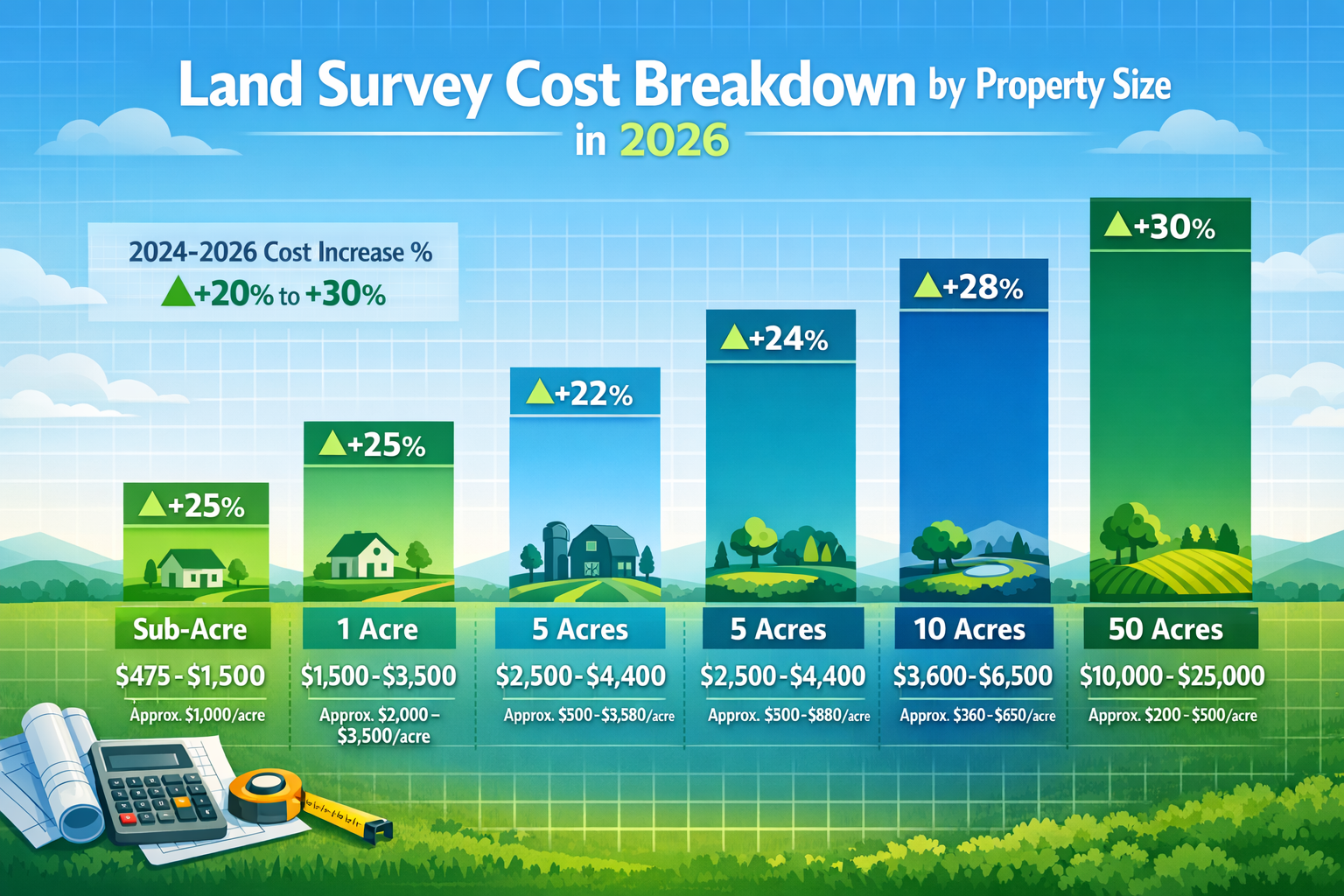
- 📏 Property size significantly impacts pricing: sub-acre plots cost £475-£1,500, while 50-acre properties range from £10,000-£25,000, with larger properties benefiting from lower per-acre rates[2][3]
- 🗺️ Survey type matters tremendously: basic boundary surveys (£1,200-£5,500) cost less than comprehensive topographic surveys (£2,000-£6,500) or specialized ALTA/NSPS surveys[1][2]
- 🏞️ Terrain complexity and accessibility drive substantial cost variations, with wooded, hilly, or remote properties requiring significantly more time and specialized equipment
- 🌍 Regional variations create price differences based on local surveyor availability, urban density, regulatory requirements, and cost of living in different areas
Understanding Land Survey Fundamentals in 2026
A land survey provides a precise, professional measurement and mapping of a property's boundaries, features, and legal description. Licensed surveyors use advanced equipment and extensive research to establish property lines, identify easements, locate improvements, and document topographic features.
What Is a Land Survey?
A land survey is a detailed examination and documentation of a property conducted by a licensed professional surveyor. The surveyor researches historical records, locates physical boundary markers, takes precise measurements using modern equipment, and creates an official map showing property lines, structures, easements, and other relevant features.
In 2026, surveyors increasingly combine traditional methods with cutting-edge technology. While theodolites and measuring chains remain valuable tools, GPS receivers with centimeter-level accuracy, unmanned aerial vehicles (drones), and terrestrial laser scanners have revolutionized the profession. This technological advancement contributes to both improved accuracy and the modest cost increases observed in recent years[7].
Why Property Owners Need Surveys
Understanding when and why to commission a land survey helps property owners make informed decisions:
✅ Property purchases: Mortgage lenders often require surveys to confirm property boundaries and identify potential issues before finalizing loans
✅ Boundary disputes: Professional surveys provide legally defensible documentation when neighbors disagree about property lines, as detailed in our guide on average costs of boundary disputes
✅ Construction and development: Builders need accurate surveys before breaking ground to ensure compliance with setback requirements and zoning regulations
✅ Subdivision planning: Dividing larger parcels into multiple lots requires precise surveying to create legal descriptions for each new property
✅ Fence installation: Knowing exact boundary locations prevents costly mistakes and potential legal conflicts with adjacent property owners
✅ Title insurance: Survey documentation helps title companies identify and resolve potential boundary issues before property transfers
Breaking Down Land Survey Costs in 2026: Complete Price Ranges by Property Size
Property size represents one of the most significant factors influencing survey costs. However, the relationship isn't strictly linear—larger properties benefit from economies of scale, resulting in lower per-acre rates[2].
Cost by Acreage: Detailed Breakdown
| Property Size | Typical Cost Range | Average Per-Acre Cost |
|---|---|---|
| Sub-acre (< 1 acre) | £475 – £1,500 | £475 – £1,500 |
| 1 acre | £1,500 – £3,500 | £1,500 – £3,500 |
| 5 acres | £2,500 – £4,400 | £500 – £880 |
| 10 acres | £3,600 – £6,500 | £360 – £650 |
| 50 acres | £10,000 – £25,000 | £200 – £500 |
The data clearly demonstrates how per-acre costs decrease as property size increases[2][3]. A one-acre property might cost £2,500 to survey (£2,500 per acre), while a 50-acre parcel costing £15,000 works out to just £300 per acre.
Small Residential Properties (Under 1 Acre)
For typical suburban and urban residential lots under one acre, expect to pay between £475 and £1,500 for a standard boundary survey[2][3]. These smaller properties often involve:
- Simpler boundary identification with fewer corners
- Easier accessibility in developed neighborhoods
- Less time required for fieldwork
- Straightforward legal descriptions
However, even small properties can exceed this range when complications arise. A quarter-acre urban lot with disputed boundaries, multiple easements, or complex historical records might cost £2,000 or more.
Medium Properties (1-10 Acres)
Properties in the 1-10 acre range represent common sizes for rural residential parcels, small farms, and hobby properties. Survey costs typically range from £1,500 to £6,500[2][3]:
- 1-acre properties: £1,500 – £3,500
- 5-acre properties: £2,500 – £4,400
- 10-acre properties: £3,600 – £6,500
These medium-sized properties often require more extensive boundary marking, especially when natural features like streams or wooded areas form property lines. The surveyor must locate all corners, which may involve significant walking distances and clearing vegetation to establish sight lines.
Large Properties (10+ Acres)
Larger rural properties, farms, and development parcels require substantial investment in surveying services. For a 50-acre property, expect costs between £10,000 and £25,000[2][3]. Factors affecting large property surveys include:
🌲 Terrain complexity: Wooded areas require clearing sight lines between boundary markers
⛰️ Topographic variation: Hilly or mountainous terrain increases difficulty and time requirements
🚜 Accessibility: Remote properties may require all-terrain vehicles or even hiking to reach boundaries
📋 Historical research: Larger parcels often have more complex ownership histories requiring extensive title research
Despite higher absolute costs, large property owners benefit from significantly lower per-acre rates, making comprehensive surveys more economically feasible.
Types of Land Surveys and Their Associated Costs
Different survey types serve distinct purposes and carry varying price tags. Understanding these differences helps property owners select the appropriate survey for their specific needs.
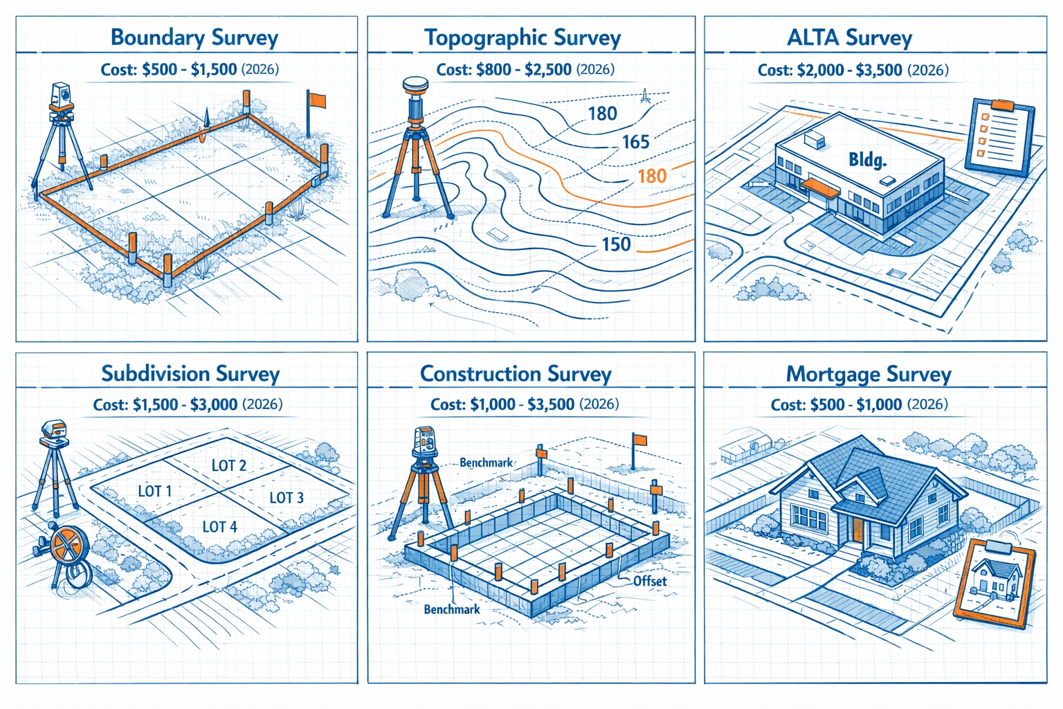
Boundary Survey (£1,200 – £5,500)
The most common type of residential survey, a boundary survey establishes precise property lines and identifies corner markers. Surveyors research property deeds, locate existing monuments, and place new markers where needed[2].
Boundary surveys typically include:
- Research of property records and adjacent parcels
- Field measurements using GPS and traditional equipment
- Location and documentation of boundary markers
- Identification of encroachments or easements
- Detailed map showing property boundaries
These surveys prove essential when installing fences, resolving disputes, or purchasing property. The cost varies based on property size, boundary complexity, and local terrain conditions.
Topographic Survey (£2,000 – £6,500)
Topographic surveys map both property boundaries and elevation changes, natural features, and existing improvements[1][2]. These comprehensive surveys document:
- Contour lines showing elevation changes
- Location of trees, streams, and other natural features
- Existing structures and improvements
- Utility locations and easements
- Drainage patterns and water features
Architects, engineers, and developers rely on topographic surveys when planning construction projects. The detailed elevation data helps design proper drainage, foundation placement, and grading plans. Costs range from £2,000 to £6,500 depending on property size and required detail level[1][2].
ALTA/NSPS Survey (£2,000 – £10,000+)
The ALTA/NSPS survey (American Land Title Association/National Society of Professional Surveyors) represents the most comprehensive and detailed survey type. Commercial real estate transactions often require these surveys, which include:
- Complete boundary determination
- Location of all improvements and utilities
- Identification of easements and rights-of-way
- Zoning compliance verification
- Detailed legal description
- Title commitment review
Due to their comprehensive nature and strict standards, ALTA surveys typically cost £2,000 to £10,000 or more, with complex commercial properties potentially exceeding £15,000[5].
Subdivision Survey (£3,000 – £15,000+)
When dividing a larger parcel into multiple lots, a subdivision survey creates legal descriptions for each new property. This complex process involves:
- Designing lot layouts complying with zoning requirements
- Creating legal descriptions for each lot
- Establishing new boundary markers
- Preparing plat maps for government approval
- Coordinating with planning departments
Subdivision surveys typically cost £3,000 to £15,000 or more, depending on the number of lots created and regulatory complexity[4].
Construction/Site Survey (£1,500 – £5,000)
Builders commission construction surveys to guide development projects. These surveys establish:
- Building corners and foundation locations
- Elevation benchmarks for grading
- Utility connection points
- Setback compliance verification
Construction surveys typically range from £1,500 to £5,000, with costs varying based on project complexity and required staking[4].
For those planning building projects, understanding survey requirements complements other essential assessments like Level 2 vs Level 3 surveys for existing structures.
Key Factors Influencing Land Survey Costs in 2026
Beyond property size and survey type, numerous variables affect final pricing. Understanding these factors helps property owners anticipate costs and identify potential budget impacts.
Property Characteristics
Terrain complexity significantly impacts survey costs. A flat, cleared lot in a subdivision requires minimal effort compared to wooded, hilly, or wetland properties. Surveyors may need to:
- Clear vegetation to establish sight lines between markers
- Use specialized equipment for difficult terrain
- Make multiple visits due to accessibility challenges
- Employ additional crew members for safety in remote areas
Property shape also matters. Irregular parcels with numerous corners require more time to survey than simple rectangular lots. A property with 12 boundary corners takes considerably longer than one with just four.
Accessibility affects both time and equipment requirements. Properties accessible only by foot or requiring special vehicles increase costs. Remote locations may also involve travel time charges.
Research and Documentation Requirements
The complexity of property records influences survey costs. Properties with:
- Clear, recent surveys require minimal research
- Disputed boundaries need extensive historical investigation
- Multiple previous owners demand thorough title research
- Conflicting deed descriptions require resolution
Surveyors typically spend significant time researching county records, historical surveys, and adjacent property documents before beginning fieldwork. Complex title histories can add hundreds of pounds to survey costs.
Local Market Conditions
Regional variations in surveyor availability and cost of living create price differences across the country. Urban areas with high demand and limited surveyors typically charge premium rates. Rural areas may offer lower base rates but charge additional travel fees.
Construction activity in an area affects surveyor availability and pricing. During building booms, increased demand for surveying services can drive prices upward. Conversely, slower construction periods may offer opportunities for competitive pricing.
Technology and Equipment
Modern surveying increasingly relies on advanced technology:
🛰️ GPS/GNSS systems provide centimeter-level accuracy but require significant equipment investment
🚁 Drone mapping efficiently captures topographic data for larger properties
📡 3D laser scanning creates detailed digital models of properties and structures
💻 Computer-aided design (CAD) software produces professional survey documents
While technology improves accuracy and efficiency, it also contributes to the modest cost increases observed in 2026. Surveyors must invest in equipment, training, and software subscriptions, costs reflected in service pricing[7].
Regulatory Requirements
Local regulations and permit requirements vary by jurisdiction. Some municipalities require:
- Specific survey types for certain transactions
- Government review and approval of survey documents
- Additional certifications or stamps
- Compliance with local surveying standards
These requirements add time and complexity, potentially increasing costs. Properties in heavily regulated areas or those requiring multiple government approvals typically incur higher survey expenses.
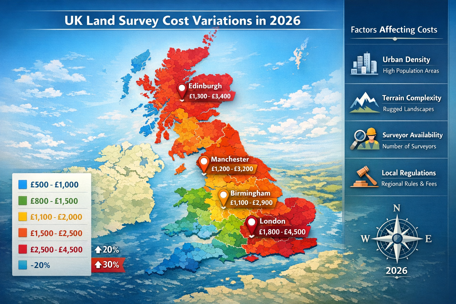
Regional Variations in Land Survey Costs Across the UK
Geographic location significantly influences survey pricing due to variations in surveyor availability, cost of living, terrain characteristics, and local market conditions.
London and Southeast England
The London metropolitan area and Southeast England typically experience the highest survey costs due to:
- High cost of living and business operation expenses
- Strong demand from active property markets
- Complex urban properties with multiple easements
- Premium pricing for professional services
Residential boundary surveys in London often range from £1,800 to £4,500, significantly above the national average[2]. Properties in areas served by chartered surveyors in Chelsea, Islington, or Hammersmith typically fall in this higher range.
Suburban areas like Epsom, Richmond, and Putney may offer slightly lower rates while still exceeding national averages.
Regional Cities and Towns
Regional urban centers like Manchester, Birmingham, Leeds, and Edinburgh typically charge moderate rates:
- £1,200 to £3,200 for standard residential surveys
- Lower cost of living compared to London
- Adequate surveyor availability in most areas
- Competitive pricing due to multiple providers
Smaller towns and suburban areas generally offer the most competitive pricing while maintaining professional standards.
Rural and Remote Areas
Rural properties present unique pricing considerations:
✅ Lower base rates due to reduced operating costs
❌ Travel charges for properties distant from surveyor offices
❌ Terrain challenges in agricultural or wooded areas
❌ Limited surveyor availability in some regions
A rural property might have a base survey cost of £1,000 but incur an additional £300-£500 in travel fees and terrain-related charges, potentially equalizing costs with urban areas.
Counties like Oxfordshire and Essex offer mixed pricing depending on specific location proximity to major towns.
Scotland, Wales, and Northern Ireland
The devolved nations each have distinct surveying markets:
Scotland: Edinburgh and Glasgow command premium pricing similar to regional English cities, while Highland properties may incur significant travel charges despite lower base rates.
Wales: Generally offers competitive pricing, though mountainous terrain in North Wales can increase costs for topographic surveys.
Northern Ireland: Belfast area pricing aligns with regional UK cities, with rural areas offering lower base rates but potential travel premiums.
Cost Comparison: 2024 vs. 2026 Trends
Understanding how survey costs have evolved helps property owners contextualize current pricing and anticipate future trends.
Inflation Impact
The UK experienced cumulative inflation of approximately 8-12% between 2024 and 2026, affecting surveying costs through:
- Increased equipment and technology expenses
- Higher fuel costs for travel to properties
- Rising insurance and professional liability premiums
- General business operating cost increases
Survey prices have risen 5-10% on average during this period, slightly below general inflation rates due to efficiency gains from technology adoption[7].
Technology Adoption Effects
While technology investment increases upfront costs, it also improves efficiency:
Positive impacts:
- Faster data collection reduces fieldwork time
- Improved accuracy minimizes return visits
- Digital deliverables reduce printing and mailing costs
- Remote sensing reduces physical accessibility challenges
Cost pressures:
- Significant equipment investment (£20,000-£100,000+ for advanced systems)
- Ongoing software subscription fees
- Required training and certification
- Equipment maintenance and updates
The net effect has been modest price increases accompanied by improved service quality and faster turnaround times.
Construction Boom Influence
The UK construction sector experienced significant activity in 2024-2026, driven by:
- Government housing initiatives
- Commercial development projects
- Infrastructure investments
- Renovation and extension activity
Increased demand for surveying services during peak construction periods created pricing pressure, particularly in high-growth areas. Surveyors in some regions reported 6-12 month backlogs during peak periods, allowing premium pricing for expedited services.
Comparison Table: 2024 vs. 2026 Average Costs
| Survey Type | 2024 Average | 2026 Average | % Increase |
|---|---|---|---|
| Boundary Survey (1 acre) | £2,200 | £2,400 | 9.1% |
| Topographic Survey | £3,800 | £4,100 | 7.9% |
| ALTA Survey | £5,500 | £6,000 | 9.1% |
| Basic Residential | £900 | £975 | 8.3% |
These increases reflect combined influences of inflation, technology investment, and market demand, while remaining relatively modest compared to other professional services.
Hidden Costs and Additional Fees to Consider
The quoted survey price often represents just the base service. Property owners should budget for potential additional expenses:
Research and Title Examination Fees
Complex properties may require extensive historical research beyond standard title examination:
- County record searches: £100-£300
- Historical survey reconstruction: £200-£500
- Adjacent property research: £150-£400
- Deed interpretation: £100-£250
Properties with unclear boundaries or conflicting historical records typically incur these additional research costs.
Vegetation Clearing
Wooded properties often require clearing sight lines between boundary markers:
- Minor clearing: £200-£500
- Moderate vegetation removal: £500-£1,200
- Extensive clearing: £1,200-£3,000+
Some surveyors include limited clearing in base pricing, while others charge separately. Clarify this before engaging services.
Corner Marker Installation
Replacing missing or damaged boundary markers adds costs:
- Iron pins: £50-£100 per marker
- Concrete monuments: £100-£200 per marker
- Stone markers: £150-£300 per marker
Properties with four corners need four markers, potentially adding £200-£1,200 to survey costs.
Rush Fees
Expedited service typically commands premium pricing:
- Standard turnaround: 2-4 weeks (no additional fee)
- Expedited service: 1-2 weeks (10-20% premium)
- Rush service: Under 1 week (25-50% premium)
During peak construction seasons, even standard turnaround times may extend to 6-8 weeks without rush fees.
Travel and Accessibility Charges
Remote or difficult-to-access properties may incur:
- Mileage fees: £0.50-£1.00 per mile beyond standard service area
- Special equipment: £200-£500 for all-terrain vehicles or boats
- Additional crew members: £300-£600 per day for safety requirements
Revision and Update Fees
Modifying surveys after initial completion typically costs:
- Minor corrections: £100-£300
- Significant revisions: £300-£800
- Complete re-survey: 50-75% of original cost
Clearly communicate requirements upfront to minimize revision needs.
Budgeting Tips for Property Owners in 2026
Strategic planning helps property owners manage survey costs effectively while ensuring quality service.
Get Multiple Quotes
Request quotes from 3-5 licensed surveyors to establish competitive pricing. Ensure quotes include:
✓ Specific survey type and scope
✓ Property size and location
✓ Estimated completion timeline
✓ Deliverables included (digital files, physical copies, etc.)
✓ Additional fees and potential extra charges
Compare not just price but also qualifications, experience, and client reviews. The lowest quote isn't always the best value.
Timing Considerations
Survey during off-peak seasons when possible:
- Peak season (April-October): Higher demand, premium pricing, longer waits
- Off-season (November-March): Better availability, potential discounts, faster turnaround
Weather considerations may limit winter surveying in some regions, but many properties can be surveyed year-round with modern equipment.
Bundle Services
If requiring multiple surveying services, bundling can reduce costs:
- Boundary + topographic survey together
- Survey + staking for construction
- Multiple properties surveyed simultaneously
Surveyors often offer 10-20% discounts for bundled services since they minimize duplicate research and travel.
Prepare the Property
Reduce costs by preparing the property before the surveyor arrives:
🔍 Locate existing markers: Finding old boundary pins saves surveyor time
🌿 Clear basic vegetation: Removing obvious obstructions along property lines
📄 Gather documents: Providing previous surveys, deeds, and title documents
🗺️ Identify concerns: Clearly communicate specific issues or questions
These preparations can reduce fieldwork time by several hours, potentially saving £200-£500.
Understand What You Need
Don't over-buy surveying services. Match the survey type to your actual requirements:
- Simple fence installation: Basic boundary survey
- Property purchase: Boundary or mortgage survey
- Construction project: Topographic or construction survey
- Commercial transaction: ALTA survey
Purchasing a comprehensive ALTA survey when a simple boundary survey suffices wastes money. Conversely, inadequate surveys may require costly re-work.
Consider Long-Term Value
While survey costs seem significant, they provide lasting value:
- Legal protection in boundary disputes
- Accurate property information for future projects
- Increased property value through clear documentation
- Reduced risk of costly construction mistakes
A £2,500 survey that prevents a £15,000 boundary dispute or construction error represents excellent value. This parallels the value of comprehensive building surveys when purchasing property.
Check for Existing Surveys
Research whether recent surveys exist before commissioning new work:
- Contact previous property owners
- Check county recorder's office
- Review title insurance documents
- Ask real estate agents or solicitors
A recent survey (within 5-10 years) might suffice with minor updates costing £300-£800 rather than a complete new survey.
Selecting the Right Surveyor: Qualifications and Questions
Choosing a qualified, experienced surveyor ensures accurate results and fair pricing.
Essential Qualifications
Verify that surveyors possess:
📜 Professional licensure: Current license from relevant regulatory body
🏛️ Professional memberships: RICS (Royal Institution of Chartered Surveyors) or similar organizations
💼 Professional liability insurance: Adequate coverage for potential errors
🎓 Relevant experience: Track record with similar property types
📊 Local knowledge: Familiarity with area regulations and characteristics
Licensed surveyors complete extensive education, pass rigorous examinations, and maintain continuing education requirements. Never hire unlicensed individuals regardless of cost savings.
Questions to Ask Prospective Surveyors
Before engaging a surveyor, ask:
- What specific survey type do you recommend for my needs?
- What is your total estimated cost, including all potential additional fees?
- What is your typical turnaround time?
- What deliverables will I receive (digital files, paper copies, etc.)?
- How do you handle discovered discrepancies or boundary disputes?
- What is your experience with properties similar to mine?
- Can you provide references from recent clients?
- What happens if the survey reveals unexpected issues?
- Do you offer any warranties or guarantees on your work?
- How do you communicate progress and findings?
Professional surveyors welcome these questions and provide clear, detailed answers. Evasive responses or reluctance to provide information raises red flags.
Red Flags to Avoid
Be cautious of surveyors who:
❌ Lack proper licensing or insurance
❌ Provide quotes without visiting the property or reviewing documents
❌ Offer prices significantly below market rates
❌ Cannot provide references or examples of previous work
❌ Use outdated equipment or methods exclusively
❌ Pressure immediate decisions without allowing comparison shopping
❌ Refuse to provide written contracts or detailed quotes
Understanding Surveyor Liability
Professional surveyors carry errors and omissions (E&O) insurance protecting clients from mistakes. However, this coverage has limits:
✓ Covered: Mathematical errors, missed boundary markers, incorrect measurements
✗ Not covered: Changes in property boundaries after survey completion, client misuse of survey data
Understanding liability limitations helps set realistic expectations and emphasizes the importance of hiring qualified professionals.
Frequently Asked Questions About Land Survey Costs
How long does a typical land survey take?
Timeline varies by property size and complexity:
- Small residential lots: 1-3 days for fieldwork, 1-2 weeks total
- 1-5 acre properties: 2-5 days fieldwork, 2-3 weeks total
- Large parcels: 1-2 weeks fieldwork, 3-6 weeks total
Research, document preparation, and quality review extend timelines beyond fieldwork. During peak seasons, scheduling delays may add 2-8 weeks.
Do I need a survey if I'm not buying or selling property?
Surveys benefit property owners in numerous situations:
- Installing fences along property lines
- Planning additions or outbuildings
- Resolving neighbor disputes
- Subdividing property
- Obtaining construction permits
- Updating title insurance
Even without transactions, surveys provide valuable property documentation and prevent costly mistakes.
Can I use an old survey instead of getting a new one?
Possibly, depending on age and purpose:
✓ Acceptable: Recent surveys (under 5 years) for general reference
✓ Possibly acceptable: Surveys under 10 years with minor updates
✗ Generally unacceptable: Surveys over 10 years old or when property changes occurred
Lenders typically require current surveys for mortgage transactions. Consult with your surveyor about whether existing surveys meet your needs.
What's the difference between a survey and a property appraisal?
Surveys and appraisals serve completely different purposes:
Land Survey:
- Measures physical boundaries and features
- Conducted by licensed surveyors
- Focuses on property dimensions and legal description
- Required for construction, disputes, and transactions
Property Appraisal:
- Determines property market value
- Conducted by licensed appraisers
- Focuses on comparable sales and property condition
- Required for mortgages and valuations
Both may be necessary for property transactions. For comprehensive property assessments, consider professional valuation services alongside surveying.
Does homeowner's insurance cover survey costs?
Generally no. Standard homeowner's insurance doesn't cover survey costs as they're considered routine property maintenance rather than insurable events. However, some policies may cover surveys needed after:
- Natural disasters affecting property boundaries
- Vandalism or theft of boundary markers
- Specific covered perils requiring property documentation
Review your policy or consult your insurance agent for specific coverage details.
How can I verify property boundaries without a full survey?
Limited options exist for informal boundary verification:
- Review property deeds for legal descriptions
- Locate existing boundary markers (if present and reliable)
- Examine previous surveys (if available)
- Consult county GIS mapping systems (approximate only)
However, none of these methods provide legally defensible boundary documentation. For legal certainty, especially before construction or in dispute situations, professional surveys remain essential.
The Future of Land Surveying: Technology and Cost Implications
The surveying profession continues evolving rapidly, with technological advances reshaping service delivery and pricing structures.
Emerging Technologies
Artificial intelligence and machine learning increasingly assist with:
- Automated data processing and analysis
- Pattern recognition in historical records
- Predictive modeling for boundary determination
- Quality control and error detection
LiDAR (Light Detection and Ranging) technology enables:
- Rapid topographic data collection
- Vegetation penetration for ground surface mapping
- Detailed 3D modeling of properties
- Efficient large-area surveys
Blockchain technology may revolutionize:
- Property record storage and verification
- Survey document authentication
- Title transfer processes
- Boundary dispute resolution
Cost Trajectory Predictions
Industry analysts project modest continued cost increases through 2028:
- 2026-2028 projected increase: 4-7% annually
- Primary drivers: Technology investment, regulatory compliance, labor costs
- Offsetting factors: Improved efficiency, automation, competitive pressure
However, technology adoption may eventually reduce costs for routine surveys while maintaining premium pricing for complex properties requiring human expertise and judgment.
Environmental and Sustainability Considerations
Modern surveying increasingly incorporates environmental awareness:
- Minimizing vegetation disturbance during fieldwork
- Using electric or hybrid vehicles for property access
- Digital-only deliverables reducing paper consumption
- Drone technology reducing ground disturbance
These sustainable practices may slightly increase short-term costs but align with broader environmental goals and client preferences.
Conclusion: Making Informed Decisions About Land Survey Costs in 2026
Understanding Land Survey Costs in 2026: Complete Guide to Pricing Factors and Regional Variations empowers property owners to make informed decisions about this essential professional service. With national averages around £2,300 but actual costs ranging from £475 to £25,000 depending on numerous factors, proper budgeting requires careful consideration of property size, survey type, terrain complexity, and regional variations[2][3].
The modest cost increases observed in 2026 reflect reasonable adjustments for inflation, technology adoption, and strong construction activity rather than excessive price inflation. Property owners receive improved service quality, faster turnaround times, and enhanced accuracy compared to previous years, making current pricing competitive with historical standards.
Actionable Next Steps
Property owners should:
-
Assess specific survey needs based on intended use (boundary determination, construction planning, dispute resolution, etc.)
-
Research qualified surveyors in their area, verifying licenses, experience, and professional credentials
-
Obtain multiple detailed quotes including all potential fees and additional charges
-
Review timing considerations to potentially access off-peak pricing and availability
-
Prepare properties by gathering existing documentation and clearing basic obstructions
-
Budget appropriately including 10-20% contingency for unexpected complications
-
Maintain survey documentation for future reference and property value
For property owners requiring comprehensive assessments beyond land surveys, exploring full building surveys and understanding what building surveyors assess provides additional valuable property insights.
Professional land surveys represent significant investments that deliver lasting value through legal protection, accurate property documentation, and risk mitigation. By understanding the factors driving costs and selecting qualified professionals, property owners ensure they receive fair pricing for essential services that protect their most valuable assets.
The surveying profession's continued evolution through technology adoption promises improved service delivery while maintaining the professional expertise and legal defensibility that only licensed surveyors provide. As 2026 progresses, property owners can approach survey decisions with confidence, armed with comprehensive knowledge of pricing factors, regional variations, and strategies for maximizing value from this critical professional service.
References
[1] Blog Land Survey Costs 2026 – https://www.thelandgeek.com/blog-land-survey-costs-2026/
[2] How Much Does Land Survey Cost – https://www.angi.com/articles/how-much-does-land-survey-cost.htm
[3] Land Survey Cost – https://todayshomeowner.com/lawn-garden/cost/land-survey-cost/
[4] Land Survey Cost – https://www.mysiteplan.com/blogs/news/land-survey-cost
[5] How Much Is A Property Survey – https://www.benzinga.com/money/how-much-is-a-property-survey
[6] Boundary Survey Cost Price – https://haller-blanchard.com/boundary-survey-cost-price/
[7] Land Surveying Market Report – https://www.cognitivemarketresearch.com/land-surveying-market-report