The property surveying industry is experiencing its most dramatic transformation in decades. What once required teams of surveyors spending weeks in the field with traditional equipment can now be accomplished in hours by a single operator with an unmanned aerial vehicle (UAV). Revolutionizing Land Surveys: How Drone Technology and UAVs Are Transforming Property Mapping in 2026 represents not just an incremental improvement, but a fundamental shift in how professionals approach topographic data collection, property boundary mapping, and infrastructure assessment.
As affordable drones equipped with LiDAR sensors and high-resolution cameras become increasingly accessible, surveying firms worldwide are discovering unprecedented opportunities for cost reduction and efficiency gains. Major construction companies are reporting savings exceeding $80,000 annually while simultaneously improving data accuracy and project timelines.[4] This technological revolution is reshaping everything from archaeological discoveries to urban planning initiatives, creating new possibilities that were simply impossible with ground-based methods alone.
Key Takeaways
✅ Dramatic cost and time savings: Drone surveys deliver the same data quality as traditional methods but complete projects in hours instead of weeks, with documented annual savings exceeding $80,000 for firms integrating UAV technology.[2][4]
✅ Advanced sensor technology: LiDAR-equipped drones can penetrate dense vegetation to create accurate 3D terrain models, while RTK positioning systems ensure centimeter-level accuracy for professional surveying applications.[2][4]
✅ Multi-industry applications: From construction progress monitoring and agricultural crop assessment to archaeological site discovery and environmental conservation, drone surveying is transforming data collection across diverse sectors.[2]
✅ Enhanced safety protocols: UAVs eliminate many hazards associated with traditional surveying by capturing data from the air, reducing the need for personnel to navigate dangerous terrain or hazardous environments.[2]
✅ Cloud-based integration workflows: Modern drone surveying platforms integrate seamlessly with GIS software and CAD systems, enabling real-time collaboration and comparative analysis between planned designs and actual site conditions.[4]
Understanding the Drone Surveying Revolution
What Makes Drone Technology Different from Traditional Surveying Methods
Traditional land surveying has relied on ground-based instruments like theodolites, total stations, and GPS receivers for decades. Surveyors would physically traverse properties, setting up equipment at multiple locations to establish reference points and collect elevation data. This process, while accurate, requires substantial time, personnel, and resources—especially for large or difficult-to-access sites.
Drone surveying fundamentally changes this equation. Instead of ground-based measurements, UAVs capture data from above using specialized sensors and cameras. A single drone flight can collect thousands of high-resolution images across dozens of acres in a matter of hours.[2] These images are then processed using photogrammetry software to create detailed maps, 3D models, and topographic surveys with accuracy comparable to traditional methods.
The key differentiators include:
- 📊 Speed: What takes days or weeks with ground crews takes hours with drones
- 💰 Cost: Significantly reduced labor and equipment expenses
- 🎯 Accessibility: Ability to survey dangerous, remote, or difficult terrain safely
- 📈 Data density: Capture of comprehensive visual and spatial information in a single flight
- 🔄 Repeatability: Easy to conduct follow-up surveys for progress monitoring
For property owners and developers seeking comprehensive assessments, understanding these advantages helps explain why building surveys are increasingly incorporating aerial data collection methods.
The Core Technologies Powering Modern UAV Surveying
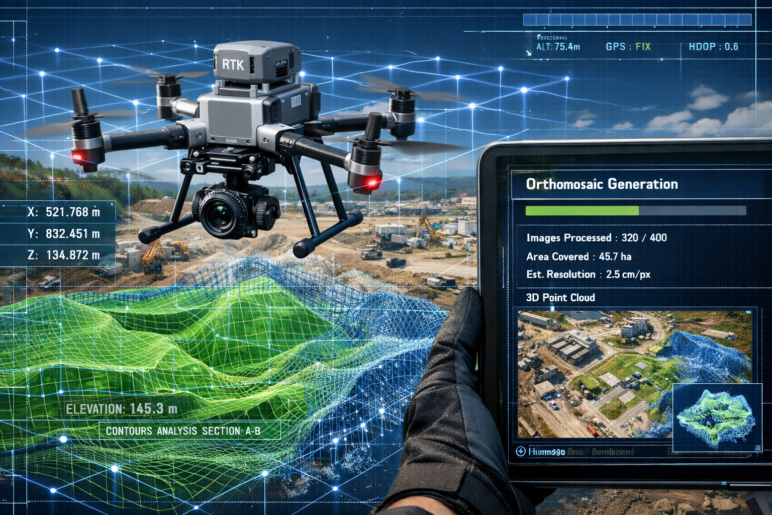
Photogrammetry forms the foundation of most drone surveying applications. This technique involves capturing multiple overlapping photographs from different angles, then using specialized software to identify common points between images. Through complex mathematical calculations, the software reconstructs three-dimensional models of the surveyed area, complete with accurate measurements and coordinates.
LiDAR (Light Detection and Ranging) represents the cutting edge of drone-based terrain mapping. LiDAR sensors emit rapid laser pulses—sometimes hundreds of thousands per second—and measure how long each pulse takes to reflect back from the ground surface. This creates incredibly detailed "point clouds" containing millions of precise elevation measurements.[2]
The revolutionary aspect of LiDAR technology lies in its ability to penetrate vegetation. Traditional aerial photography can only capture what's visible from above, but LiDAR pulses can pass through gaps in tree canopy to reach the ground surface below. This capability has proven invaluable for archaeological surveys, where researchers have discovered previously unknown ancient structures hidden beneath dense forest cover.[2]
RTK (Real-Time Kinematic) positioning enhances GPS accuracy from meter-level precision to centimeter-level accuracy. Drones like the Phantom 4 RTK, deployed by major construction firms including Skanska Norge, use RTK technology to ensure that every captured image has extremely precise location data.[4] This level of accuracy meets professional surveying standards and enables direct integration with engineering and architectural plans.
High-resolution cameras capture the visual detail necessary for comprehensive property assessment. Modern survey drones typically feature cameras with 20+ megapixel sensors capable of identifying features as small as a few centimeters from typical flight altitudes. This resolution enables detailed property investigations that would be difficult or impossible to conduct from ground level.
Revolutionizing Land Surveys: Quantified Benefits and Real-World Case Studies
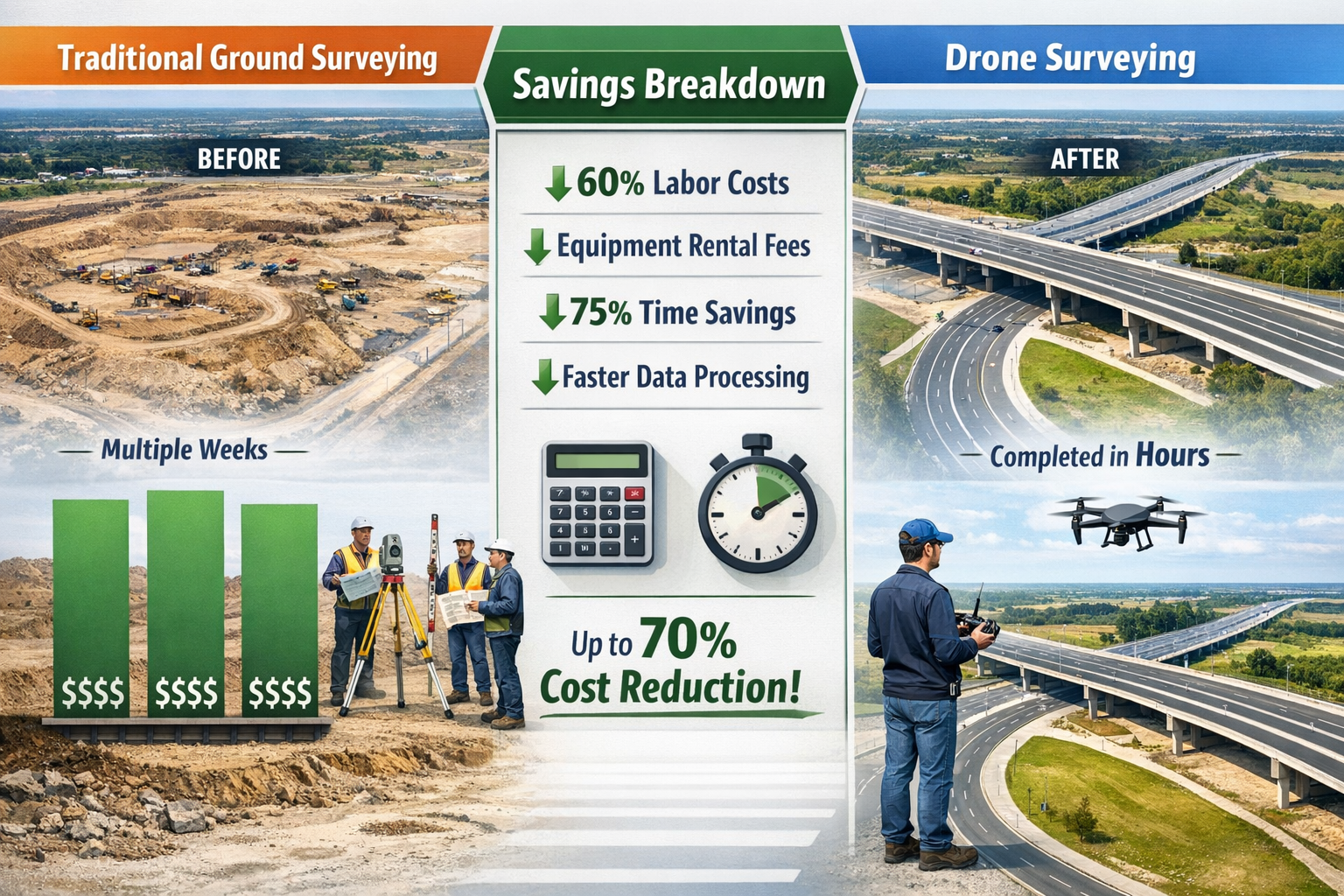
Documented Cost Savings and Efficiency Improvements
The business case for drone surveying extends far beyond theoretical advantages—organizations across industries are documenting substantial financial returns and operational improvements.
Environmental engineering firm Dudek provides a compelling example of measurable ROI. By integrating drone surveying with ArcGIS technology, the company saved more than $80,000 in a single year while simultaneously improving workflow efficiency.[4] These savings came from reduced field time, decreased equipment costs, and faster project delivery timelines that allowed the firm to take on additional work.
The cost comparison becomes even more striking when examining specific project scenarios:
| Project Aspect | Traditional Ground Survey | Drone Survey | Advantage |
|---|---|---|---|
| Time to survey 100 acres | 2-3 weeks | 4-6 hours | 90%+ faster |
| Personnel required | 3-5 surveyors | 1-2 operators | 60%+ reduction |
| Equipment costs | $50,000+ total station/GPS | $5,000-$25,000 drone system | 50%+ lower |
| Safety incidents | Higher exposure to hazards | Minimal ground exposure | Significantly safer |
| Data density | Point-based measurements | Comprehensive coverage | Exponentially greater |
These efficiency gains translate directly to bottom-line benefits. Projects that once required days or weeks of field work can now be completed in hours, allowing surveying firms to serve more clients with fewer resources.[2] For property development projects, this acceleration can significantly reduce time-to-market and associated carrying costs.
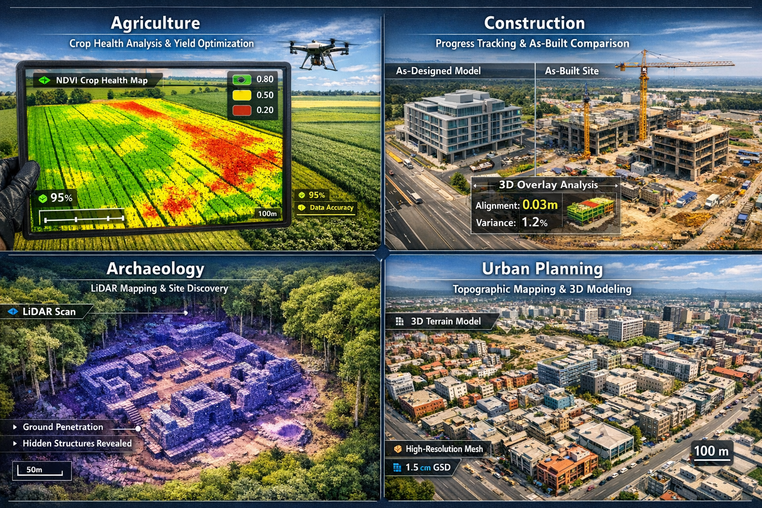
Infrastructure and Construction Success Stories
Skanska Norge, one of Scandinavia's largest construction firms, exemplifies how major infrastructure projects are leveraging drone technology. The company deployed Phantom 4 RTK drones equipped with Real-Time Kinematic positioning to monitor construction progress across large development sites.[4]
Their workflow integration demonstrates the power of combining drone data with cloud-based platforms. Project engineers upload drone imagery to cloud systems that integrate with CAD files and GIS data, creating a unified platform where stakeholders can:
- 🔍 Compare as-built conditions versus original designs in near real-time
- 📊 Track construction progress with visual documentation
- 📐 Identify discrepancies between planned and actual site conditions
- 🤝 Provide remote project access to clients and stakeholders
- 📈 Generate accurate volume calculations for earthwork and materials
This level of visibility was previously impossible or prohibitively expensive with traditional surveying methods. The ability to conduct frequent surveys without significant cost or time investment enables proactive problem identification and resolution, reducing expensive rework and project delays.
Construction progress monitoring has emerged as one of the highest-value applications. Contractors can now document site conditions weekly or even daily, creating a comprehensive visual record of project evolution. This documentation proves invaluable for dispute resolution, progress billing verification, and quality control oversight.
Agricultural and Environmental Applications
The versatility of drone surveying extends well beyond construction and development. Agricultural operations are using UAV technology to revolutionize crop management and land assessment.[2]
Farmers and agricultural consultants deploy drones equipped with multispectral cameras to:
- 🌾 Assess crop health through NDVI (Normalized Difference Vegetation Index) analysis
- 💧 Identify irrigation inefficiencies and water stress patterns
- 🌱 Monitor plant growth and development across large fields
- 🚜 Optimize fertilizer and pesticide application
- 📊 Calculate yield predictions based on vegetation analysis
Environmental conservation efforts benefit from drone surveying's ability to access remote or sensitive ecosystems without physical disturbance. Wildlife researchers track animal populations, monitor habitat changes, and assess ecosystem health using aerial surveys that would be impossible or destructive with ground-based methods.[2]
Carbon storage estimation represents an emerging application with significant climate implications. Forestry professionals use LiDAR-equipped drones to measure tree height, canopy density, and biomass—data essential for calculating carbon sequestration in forest ecosystems. This information supports carbon credit programs and environmental impact assessments.
Archaeological discovery has experienced a renaissance thanks to LiDAR technology. Archaeologists have used drone-mounted LiDAR to discover previously unknown ancient cities, settlements, and structures hidden beneath dense jungle canopy.[2] What would have required years of ground-based exploration can now be accomplished in weeks of aerial surveying, fundamentally changing how researchers approach site discovery and documentation.
Revolutionizing Land Surveys: Advanced Technologies Shaping 2026 and Beyond
Autonomous Drone Swarms and AI-Powered Surveying
The evolution from single-drone operations to autonomous drone swarms represents the next frontier in surveying technology. These coordinated systems feature multiple UAVs working together with minimal human intervention, dramatically expanding the scale and efficiency of surveying operations.[1]
Swarm technology enables:
- 🤖 Coordinated flight paths that optimize coverage and minimize redundant data collection
- ⚡ Parallel processing of large areas by distributing the workload across multiple drones
- 🔋 Extended operational time through relay systems where drones return for battery swaps while others continue surveying
- 🎯 Adaptive routing that adjusts flight patterns based on terrain features and data quality requirements
- 📡 Real-time collaboration between drones to fill coverage gaps and ensure comprehensive data capture
This technology proves particularly valuable for large-scale infrastructure projects where traditional single-drone surveys would require multiple days of flight operations. A coordinated swarm can complete the same survey in a fraction of the time, reducing project delays and enabling faster decision-making.[1]
Artificial intelligence integration is transforming how survey data gets processed and analyzed. Modern photogrammetry software incorporates machine learning algorithms that can:
- 🔍 Automatically identify and classify ground features (buildings, vegetation, roads, water bodies)
- 📊 Detect changes between survey periods for automated progress monitoring
- ⚠️ Flag potential issues or anomalies that require human review
- 📐 Generate accurate measurements and volume calculations with minimal manual input
- 🎨 Produce publication-ready deliverables with automated processing workflows
These AI capabilities reduce the specialized expertise required for data processing, making drone surveying accessible to a broader range of professionals and organizations.
Cloud-Based Integration and Real-Time Collaboration
The transition from isolated desktop software to cloud-based GIS platforms has fundamentally changed how surveying data gets shared and utilized. Leading platforms like Site Scan for ArcGIS enable seamless integration of drone imagery with existing CAD files, engineering drawings, and geographic information systems.[4]
This cloud-first approach delivers several critical advantages:
Real-time accessibility: Project stakeholders can view survey data from any location with internet access, eliminating delays associated with file transfers and report distribution. Engineers in the field can access the same data simultaneously as managers in the office, ensuring everyone works from current information.
Collaborative workflows: Multiple team members can annotate, measure, and analyze survey data concurrently. Comments, measurements, and observations get synchronized across all users, creating a shared understanding of site conditions and project requirements.
Version control: Cloud platforms automatically track changes and maintain historical records of all surveys. This creates an invaluable project timeline showing how sites evolve throughout development, useful for property investment analysis and long-term asset management.
Automated deliverable generation: Modern platforms can automatically produce standard outputs including:
- 📐 Orthomosaic maps (geometrically corrected aerial imagery)
- 🏔️ Digital elevation models (DEM) showing terrain topography
- 🎯 3D point clouds containing millions of precise measurements
- 🏗️ 3D mesh models for visualization and analysis
- 📊 Volume calculations for earthwork and material stockpiles
- 📈 Slope analysis for drainage and stability assessment
These outputs integrate directly with engineering and design software, enabling professionals to overlay survey data onto project plans for comparative analysis. The ability to quickly identify discrepancies between designed specifications and actual site conditions prevents costly errors and rework.
Industry-Specific Drone Models and Sensor Configurations
The drone surveying market has matured to offer specialized solutions for different professional applications. Understanding the appropriate technology for specific surveying needs ensures optimal results and return on investment.
Entry-level mapping drones ($1,500-$5,000) like the DJI Mavic 3 Enterprise provide sufficient accuracy for basic site documentation, progress monitoring, and visual inspections. These systems typically offer:
- 📷 20+ megapixel cameras with mechanical shutters
- 🎯 GPS positioning with 1-3 meter accuracy
- ⏱️ 30-45 minute flight times
- 📱 Mobile device-based flight planning and control
Professional survey-grade drones ($5,000-$25,000) such as the Phantom 4 RTK incorporate advanced positioning systems that deliver centimeter-level accuracy suitable for professional surveying applications.[4] These platforms feature:
- 📡 RTK/PPK positioning for survey-grade accuracy
- 🎥 High-resolution cameras optimized for photogrammetry
- 🔧 Interchangeable payload systems
- 💻 Professional flight planning software with automated mission execution
- 🌐 Integration with ground control point workflows
LiDAR-equipped systems ($25,000-$100,000+) represent the premium tier, offering capabilities impossible with camera-only systems. These specialized platforms provide:
- 🔦 Laser scanning with 100,000+ pulses per second
- 🌳 Vegetation penetration for ground surface mapping
- 📊 Direct 3D point cloud generation without photogrammetry processing
- 🎯 Consistent accuracy regardless of lighting conditions
- 🏔️ Superior performance in challenging terrain
The selection between these technology tiers depends on project requirements, accuracy specifications, and budget constraints. Many surveying firms maintain multiple drone systems to match appropriate technology to each project's specific needs, similar to how chartered surveyors select different assessment methodologies based on property characteristics.
Practical Implementation: Getting Started with Drone Surveying
Regulatory Compliance and Licensing Requirements
Before launching a drone surveying program, organizations must navigate the regulatory landscape governing commercial UAV operations. In the United Kingdom, the Civil Aviation Authority (CAA) establishes requirements for commercial drone pilots and operations.
Commercial drone operators must:
- 🎓 Obtain appropriate pilot certifications (typically the A2 Certificate of Competency for operations near people)
- 📋 Register their drones with the CAA if they weigh more than 250 grams
- 🔍 Conduct risk assessments for each operational area
- 📱 Maintain operator ID and flyer ID credentials
- ⚖️ Comply with privacy and data protection regulations (GDPR)
- 🏢 Secure appropriate insurance coverage for commercial operations
Operational restrictions that affect surveying activities include:
- 📏 Maximum altitude limits (typically 120 meters/400 feet)
- 👀 Visual line-of-sight requirements (pilot must maintain direct visual contact)
- 🏘️ Distance requirements from people, buildings, and vehicles
- ✈️ Airspace restrictions near airports and controlled zones
- 🌙 Limitations on night operations without special permissions
Understanding these requirements prevents costly project delays and legal complications. Many surveying firms find value in partnering with experienced drone service providers initially, then developing in-house capabilities as they gain familiarity with regulatory compliance.
Building an Effective Drone Surveying Workflow
Successful drone surveying requires more than just flying a UAV over a property. Professional workflows integrate multiple stages from planning through deliverable production:
1. Pre-flight planning and site assessment
- Define survey objectives and accuracy requirements
- Identify potential obstacles, hazards, and restricted areas
- Plan flight paths to ensure adequate image overlap (typically 70-80% front overlap, 60-70% side overlap)
- Establish ground control points if survey-grade accuracy is required
- Check weather conditions and lighting for optimal data capture
2. Data acquisition
- Execute automated flight missions using pre-programmed routes
- Monitor data quality during collection
- Capture supplementary manual imagery for areas of special interest
- Document ground control point locations with GPS measurements
3. Data processing and analysis
- Upload imagery to photogrammetry software
- Process images to generate orthomosaics, elevation models, and 3D outputs
- Verify accuracy against ground control points
- Conduct quality control checks for completeness and precision
4. Deliverable production
- Generate required outputs (maps, models, reports)
- Integrate with CAD/GIS systems as needed
- Prepare documentation and metadata
- Deliver results to clients or project stakeholders
This systematic approach ensures consistent quality and enables efficient scaling of surveying operations. Organizations implementing drone programs should document standard operating procedures for each workflow stage, creating repeatable processes that maintain quality as operations expand.
Integration with Traditional Surveying Methods
Rather than completely replacing traditional techniques, drone surveying works best as a complement to ground-based methods. This hybrid approach leverages the strengths of each technology while mitigating their respective limitations.
Optimal use cases for drone surveying:
- Large area topographic mapping
- Stockpile volume calculations
- Construction progress documentation
- Inaccessible or hazardous terrain
- Rapid preliminary site assessment
- Visual condition inspections
Situations where traditional methods remain preferable:
- Precise boundary surveys requiring legal accuracy
- Underground utility location
- Dense urban environments with restricted flight access
- Areas with significant tree canopy where LiDAR isn't available
- Projects requiring specific professional certifications
Many surveying projects benefit from a combined approach. For example, a comprehensive Level 3 building survey might use drone imagery to assess roof conditions and site context while employing traditional methods for detailed interior inspections and structural measurements.
Ground control points (GCPs) represent a critical integration point between drone and traditional surveying. These precisely measured reference points, established using conventional GPS or total station equipment, provide the accuracy foundation for drone-based photogrammetry. By tying aerial imagery to surveyed ground points, professionals achieve accuracy levels suitable for engineering and construction applications.
Overcoming Challenges and Limitations
Weather Dependencies and Environmental Factors
Drone surveying operations face significant weather-related constraints that can impact project timelines and data quality. Understanding these limitations enables realistic scheduling and contingency planning.
Wind conditions present the primary operational challenge. Most consumer and professional drones can operate in winds up to 20-25 mph, but stronger gusts create several problems:
- 🌪️ Reduced flight stability affecting image sharpness
- 🔋 Increased battery consumption reducing flight time
- 🎯 Positioning errors that compromise accuracy
- ⚠️ Safety risks from loss of control
Precipitation prevents most drone operations entirely. Rain damages electronic components, obscures camera lenses, and creates hazardous flight conditions. Snow and fog similarly restrict operations by limiting visibility and affecting sensor performance.
Lighting conditions significantly impact photogrammetry quality. Optimal surveying occurs during:
- ☀️ Overcast days that provide even, diffuse lighting
- ⏰ Mid-morning to mid-afternoon when sun angles minimize shadows
- 🌤️ Consistent conditions throughout the flight to ensure uniform imagery
Direct sunlight creates harsh shadows that can obscure ground features and complicate photogrammetry processing. Very low light conditions require longer camera exposures that increase motion blur risk.
These weather dependencies mean drone surveying requires flexible scheduling and backup plans. Projects in regions with unpredictable weather may need extended timelines to accommodate suitable flying conditions.
Data Processing Requirements and Technical Expertise
The accessibility of drone hardware has outpaced the simplification of data processing workflows. While flying a drone has become relatively straightforward, transforming raw imagery into useful survey products still requires significant technical expertise and computational resources.
Processing challenges include:
- 💻 Substantial computing power requirements (high-end workstations or cloud processing)
- ⏱️ Extended processing times (hours to days for large datasets)
- 🎓 Specialized software knowledge (photogrammetry, GIS, CAD systems)
- 🎯 Quality control expertise to verify accuracy and identify errors
- 📊 Understanding of coordinate systems, datums, and georeferencing
Organizations entering drone surveying often underestimate these backend requirements. A $10,000 drone investment may require an additional $5,000-$15,000 in software licenses and $3,000-$5,000 in computing hardware to effectively process the collected data.
Outsourcing data processing represents a viable alternative for organizations conducting occasional surveys. Specialized service providers can process drone imagery for $0.50-$2.00 per acre, eliminating the need for in-house expertise and infrastructure. This approach works well for firms building drone surveying capabilities gradually.
Training and skill development requires ongoing investment. Effective drone surveyors need competencies spanning:
- Piloting and flight operations
- Mission planning and data collection protocols
- Photogrammetry and image processing
- GIS and CAD software operation
- Survey accuracy verification and quality control
Many professional organizations and equipment manufacturers offer training programs specifically designed for surveying applications, helping practitioners develop these multidisciplinary skills efficiently.
Privacy Concerns and Stakeholder Management
Drone operations over private property raise legitimate privacy concerns that surveying professionals must address proactively. Even when conducting legally authorized surveys, aerial imagery can capture sensitive information about neighboring properties and individuals.
Best practices for privacy management:
- 📢 Notify adjacent property owners before conducting surveys
- 🗓️ Schedule flights during business hours when possible
- 🎥 Limit image capture to the specific survey area
- 🔒 Implement secure data storage and access controls
- 📋 Establish clear data retention and deletion policies
- ⚖️ Comply with GDPR and other privacy regulations
Transparency helps prevent conflicts and complaints. Many surveying firms provide advance notice to nearby residents, explaining the purpose of drone operations and addressing concerns before flights occur.
Data security deserves particular attention. Survey imagery often reveals valuable information about properties, infrastructure, and business operations. Implementing appropriate cybersecurity measures protects client confidentiality and prevents unauthorized access to sensitive spatial data, considerations equally important in traditional property and landlord services.
The Future of Land Surveying: Trends and Predictions
From Experimental to Standard Practice
The surveying industry has reached an inflection point where drone technology transitions from innovative experiment to established standard practice. This shift reflects several converging factors:
Proven business value: Organizations like Dudek documenting $80,000+ annual savings provide concrete evidence of ROI that justifies technology adoption.[4] As more firms publish success stories and case studies, skepticism gives way to competitive pressure to adopt proven efficiency tools.
Regulatory maturation: Aviation authorities worldwide have developed clearer frameworks for commercial drone operations, reducing uncertainty and compliance complexity. This regulatory clarity enables organizations to invest confidently in drone programs with predictable operational parameters.
Technology commoditization: Survey-grade drone systems that cost $50,000+ just five years ago now deliver comparable performance at $10,000-$25,000 price points. This affordability democratizes access, enabling small and mid-sized surveying firms to compete with larger organizations.
Workforce familiarity: A generation of surveyors trained on drone technology is entering the profession, bringing native expertise rather than requiring costly retraining. Educational programs increasingly incorporate UAV surveying into standard curricula, ensuring future professionals arrive with relevant skills.
Client expectations: Property developers, construction firms, and infrastructure owners increasingly expect drone-based deliverables as standard project components. Surveying firms without UAV capabilities risk losing competitive positioning as client expectations evolve.
These factors suggest that by 2030, drone surveying will be as commonplace as total stations and GPS receivers in professional surveying practice—not a specialized service, but a fundamental tool in every surveyor's toolkit.
Emerging Technologies on the Horizon
Several next-generation technologies promise to further revolutionize surveying capabilities over the coming years:
Quantum positioning systems under development could deliver accuracy improvements of 10-100x over current RTK systems, potentially achieving millimeter-level precision from aerial platforms without ground control points. This would eliminate one of the remaining advantages of traditional surveying methods.
AI-powered automated feature extraction will increasingly enable drones to not just capture data, but automatically identify and classify ground features. Imagine uploading drone imagery and receiving completed topographic maps with buildings, roads, vegetation, and utilities automatically identified and labeled—a workflow that currently requires hours of manual digitization.
Extended flight times through improved battery technology and hybrid power systems will enable single flights covering hundreds of acres, eliminating the current need for multiple battery swaps and flight missions. Solar-powered drones capable of multi-hour operations are already in development for specialized applications.
Beyond-visual-line-of-sight (BVLOS) operations represent perhaps the most transformative regulatory change on the horizon. Current requirements that pilots maintain direct visual contact with drones severely limit operational range and efficiency. As regulators approve BVLOS operations with appropriate safeguards, single operators could survey vast areas from centralized control stations.
Integration with Building Information Modeling (BIM) will create seamless workflows where drone surveys automatically update digital building models, enabling real-time tracking of construction progress against design specifications. This convergence of aerial data capture and 3D modeling will transform project management across the construction industry.
Implications for Surveying Professionals
The drone revolution presents both opportunities and challenges for surveying professionals navigating career development in this evolving landscape.
Expanding service offerings: Surveyors who develop drone expertise can offer clients comprehensive solutions combining traditional precision with aerial efficiency. This versatility creates competitive differentiation and enables firms to serve broader market segments, from residential property assessments to large-scale infrastructure projects.
Changing skill requirements: The profession increasingly demands multidisciplinary competencies spanning traditional surveying knowledge, drone piloting, photogrammetry processing, and GIS analysis. Professionals who invest in continuous learning and skill development will thrive in this technology-driven environment.
New business models: Drone technology enables surveying services at price points and scales previously impossible. Firms can now profitably serve smaller projects that wouldn't justify traditional surveying costs, expanding addressable markets. Subscription-based monitoring services—providing monthly or quarterly site surveys for ongoing projects—represent emerging revenue opportunities.
Collaboration opportunities: Rather than viewing technology as a threat, forward-thinking professionals recognize drones as tools that enhance rather than replace human expertise. The most successful implementations combine technological efficiency with professional judgment, similar to how surveyors add value through interpretation and analysis rather than just data collection.
The surveying profession's future belongs to professionals who embrace technological change while maintaining the analytical rigor and professional standards that define quality surveying practice. Drones represent tools that amplify human capabilities rather than replacements for professional expertise.
Conclusion: Embracing the Transformation
Revolutionizing Land Surveys: How Drone Technology and UAVs Are Transforming Property Mapping in 2026 represents far more than incremental technological improvement—it signifies a fundamental reimagining of how spatial data gets collected, processed, and utilized across industries. The evidence is compelling: organizations implementing drone surveying achieve dramatic cost reductions, efficiency improvements, and safety enhancements while maintaining or exceeding the accuracy of traditional methods.
The documented success stories—from Dudek's $80,000 annual savings to Skanska Norge's real-time construction monitoring capabilities—demonstrate that drone technology has moved decisively beyond experimental phases into proven, scalable implementation.[4] The combination of affordable hardware, powerful processing software, and cloud-based collaboration platforms has created an ecosystem where even small surveying firms can deliver sophisticated spatial analysis previously available only to large organizations with substantial resources.
Actionable Next Steps
For surveying professionals looking to integrate drone technology:
- 🎓 Invest in training: Obtain necessary pilot certifications and develop photogrammetry processing skills through professional development programs
- 🔍 Start small: Begin with pilot projects on familiar sites to develop workflows and build confidence before scaling operations
- 🤝 Partner strategically: Consider collaborations with established drone service providers while building in-house capabilities
- 💻 Evaluate software options: Test different photogrammetry and GIS platforms to identify solutions matching your workflow requirements
- 📊 Document results: Track time savings, cost reductions, and quality improvements to build internal business cases for expanded investment
For property owners and developers considering drone surveys:
- 📋 Define objectives clearly: Specify accuracy requirements, deliverable formats, and project timelines upfront
- ✅ Verify credentials: Ensure service providers maintain appropriate licenses, insurance, and regulatory compliance
- 🔄 Request sample deliverables: Review examples of orthomosaics, elevation models, and reports before committing to projects
- 💰 Compare total value: Evaluate proposals based on data quality and usability, not just initial cost
- 🔮 Plan for ongoing monitoring: Consider how periodic surveys could provide value for property development or asset management
The transformation of land surveying through drone technology will continue accelerating as autonomous systems, artificial intelligence, and sensor capabilities advance. Organizations that embrace this change strategically—investing in appropriate technology, developing necessary skills, and reimagining workflows—will discover competitive advantages that extend far beyond simple cost reduction.
The future of surveying combines the precision and professional standards of traditional practice with the efficiency, safety, and comprehensive data capture that only aerial platforms can provide. This synthesis creates unprecedented opportunities for professionals willing to adapt and clients seeking superior spatial intelligence for property decisions.
Whether you're a surveying professional exploring new capabilities or a property owner seeking comprehensive site assessment, the drone revolution offers tangible benefits available today. The question is no longer whether to adopt this technology, but how quickly you can integrate it effectively into your operations.
For expert guidance on comprehensive property assessments combining traditional expertise with modern technology, contact experienced chartered surveyors who can recommend the optimal approach for your specific needs.
References
[1] How Technology Is Revolutionizing Land Surveys – https://www.firstchoicesurveying.com/blog/how-technology-is-revolutionizing-land-surveys
[2] Drone Surveying – https://uavcoach.com/drone-surveying/
[3] Revolutionizing Land Surveying The Rise Of Drone Technology And Uav Applications In 2026 – https://nottinghillsurveyors.com/blog/revolutionizing-land-surveying-the-rise-of-drone-technology-and-uav-applications-in-2026
[4] With Gis Technology Drone Industry Alights In Reality – https://www.esri.com/about/newsroom/arcnews/with-gis-technology-drone-industry-alights-in-reality
[5] Watch – https://www.youtube.com/watch?v=CSTodaZb4Vc
[6] Webinar The State Of Drone Surveying A Strategic Briefing For 2026 – https://www.aerotas.com/blog/webinar-the-state-of-drone-surveying-a-strategic-briefing-for-2026