The surveying industry stands at a transformative crossroads in 2026. What once required weeks of manual fieldwork, physical data transfer, and lengthy processing cycles now happens in real time through cloud-connected devices that stream survey data directly to stakeholders thousands of miles away. Real-Time Data Collection and Cloud-Based Surveying Services: The Shift to Remote Operations represents more than a technological upgrade—it fundamentally reshapes how surveying professionals work, collaborate, and deliver value to clients across construction, infrastructure, mining, agriculture, and environmental monitoring sectors.
The numbers tell a compelling story. The drone mapping market alone is projected to exceed $6.5 billion by 2026[2], while over 70 percent of U.S. construction projects adopted drone surveys for mapping and monitoring in 2025[2]. Perhaps most striking, on-premises data hosting in local government plummeted from 86% in 2024 to just 13% in 2025[9], reflecting an unprecedented migration toward cloud infrastructure. This shift enables surveyors to operate remotely, automate workflows, and deliver instant results to project teams regardless of physical location.
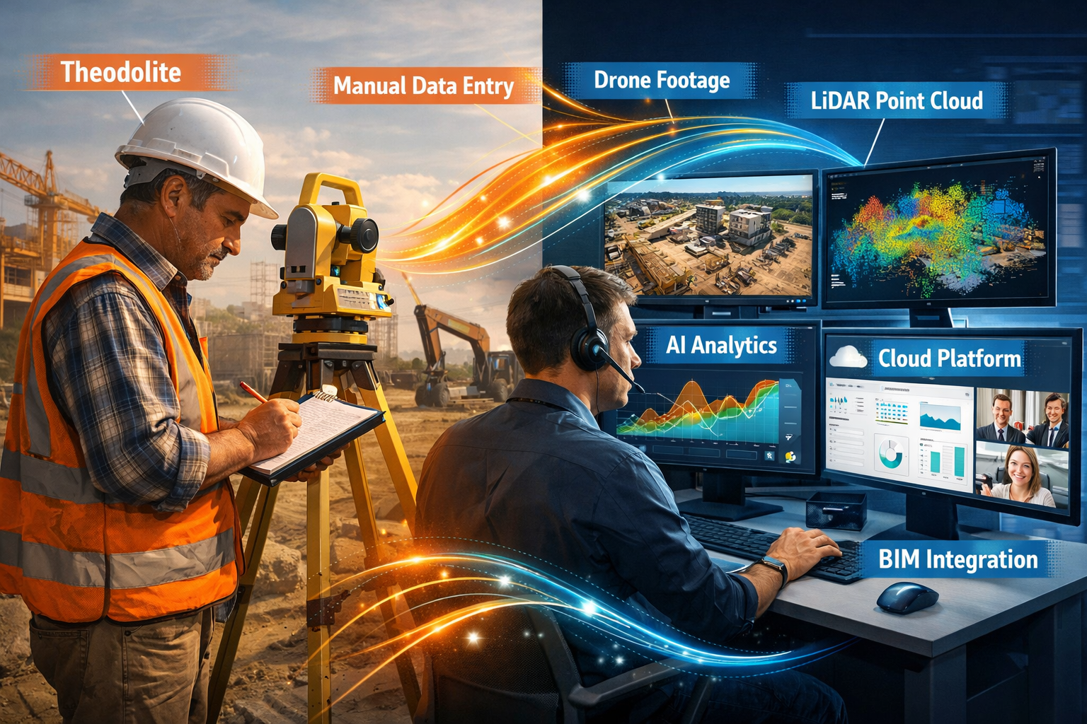
Key Takeaways
✅ Cloud platforms enable instant data access from any location with internet connectivity, eliminating traditional delays in survey data delivery and enabling real-time collaboration between field teams and remote stakeholders.
✅ AI-driven automation is reducing manual processing time by 35-60% across surveying applications, with companies demonstrating measurable improvements in inspection times, drafting workflows, and assessment cycles[2].
✅ Integrated digital workflows combining autonomous drones, LiDAR point clouds, BIM/GIS platforms, and cloud storage are replacing fragmented legacy systems, creating seamless data pipelines from field collection to final deliverables.
✅ Remote operations are expanding surveying accessibility, allowing specialists to manage multiple projects simultaneously without travel constraints while reducing operational costs and environmental impact.
✅ Standardized cloud-optimized formats (COGs, COPC, GeoParquet, STAC) are revolutionizing how large geospatial datasets are stored, accessed, and shared across organizations[6].
Understanding Real-Time Data Collection in Modern Surveying
What Makes Data Collection "Real-Time"?
Real-time data collection in surveying refers to the immediate capture, transmission, processing, and availability of survey measurements without the traditional delays inherent in manual workflows. Unlike conventional methods where surveyors collect data in the field, return to the office, download files, process information, and then share results days or weeks later, real-time systems create an unbroken digital pipeline from sensor to stakeholder.
Modern LiDAR systems create real-time point clouds that enable advances in speed and accessibility while becoming more cost-effective for a broader range of surveyors[1]. These systems capture millions of precise measurements per second, instantly transmitting them to cloud servers where automated processing begins immediately. Project managers can view preliminary survey data on their dashboards while field crews are still on-site, enabling rapid decision-making and immediate course corrections.
The transformation extends beyond speed. Real-time collection fundamentally changes the quality assurance process. Surveyors can identify data gaps, coverage issues, or equipment malfunctions immediately rather than discovering problems after leaving the site. This immediate feedback loop dramatically reduces the need for costly return visits and ensures comprehensive data capture on the first attempt.
The Technology Stack Enabling Remote Operations
Several converging technologies make remote surveying operations possible in 2026:
🛰️ Autonomous Drone Fleets: Modern surveying drones operate with minimal human intervention, following pre-programmed flight paths, automatically adjusting for weather conditions, and streaming high-resolution imagery and LiDAR data directly to cloud platforms. Aerial survey companies now deploy autonomous drone fleets streaming site data in real time to project dashboards[2], enabling continuous monitoring of large-scale projects.
☁️ Cloud Computing Infrastructure: Cloud platforms provide the computational power necessary to process massive surveying datasets instantly. Cloud computing enables easier access to information, real-time sharing across multiple devices from any location with internet connection, automated scans, and improved collaboration between surveyors[1]. The scalability of cloud storage allows surveying companies to expand processing power and storage capacity with ease while reducing maintenance costs[1].
🤖 AI-Driven Analytics: Artificial intelligence transforms raw survey data into actionable insights automatically. AI-driven analytics, advanced LiDAR, and seamless integration with BIM and GIS platforms now form the backbone of modern aerial surveying[2]. AI algorithms automatically identify features, detect changes, measure volumes, classify terrain, and flag potential issues without human intervention.
📱 Mobile-First Interfaces: Cloud-based surveying platforms deliver data through responsive interfaces optimized for tablets and smartphones, enabling stakeholders to review survey results, annotate findings, and approve deliverables from any device. This accessibility democratizes survey data, making it available to entire project teams rather than limiting access to specialized personnel.
For organizations conducting comprehensive property assessments, understanding how these technologies integrate with traditional surveying methods remains essential. Our building survey services combine modern data collection techniques with established professional standards.
Cloud-Based Surveying Services: Architecture and Advantages
How Cloud Platforms Transform Surveying Workflows
Cloud-based surveying services represent a fundamental architectural shift from local data storage and processing to distributed, internet-accessible systems. This transformation addresses critical challenges that emerged as surveying technologies advanced. High-resolution imagery, dense point clouds, and continuous monitoring generate terabytes of data that overwhelm traditional local storage systems.
The cloud architecture solves multiple problems simultaneously:
Data Accessibility: Survey data stored in the cloud becomes instantly available to authorized users worldwide. A project manager in London can review survey data collected that morning in Manchester, annotate specific areas of concern, and share those annotations with the field crew—all within minutes. This eliminates the delays inherent in physical data transfer and enables truly collaborative workflows.
Computational Scalability: Processing dense LiDAR point clouds or generating high-resolution orthomosaics requires substantial computing power. Cloud platforms provide scalable processing power that automatically adjusts to workload demands[1]. Surveying companies can process multiple large datasets simultaneously during peak periods without investing in expensive local hardware that sits idle during slower periods.
Automated Backup and Version Control: Cloud systems automatically create redundant copies of survey data across multiple geographic locations, protecting against data loss from equipment failure, accidents, or disasters. Version control features track every modification, enabling teams to review historical data and understand how survey interpretations evolved over time.
Standardized Data Formats: Modern geospatial professionals are adopting cloud-optimized formats including COGs (Cloud Optimized GeoTIFFs), COPC (Cloud Optimized Point Clouds), Zarr, GeoParquet, and STAC protocols to revolutionize how large datasets are stored, accessed, and shared with improved discoverability[6]. These formats enable efficient streaming of only the data portions needed for specific tasks, dramatically reducing bandwidth requirements and loading times.
Measurable Efficiency Gains from Cloud Migration
The transition to cloud-based surveying delivers quantifiable improvements across multiple metrics. Individual companies demonstrated significant efficiency gains in 2025:
| Company/Project | Application | Efficiency Improvement | Source |
|---|---|---|---|
| SAM | Energy infrastructure inspection | 35% reduction in inspection times | [2] |
| AirWorks | Automated site plan generation | 50% reduction in drafting time | [2] |
| Mapware | Agricultural crop assessment | 60% reduction in assessment times | [2] |
| Aerial Insight Services | Mining site permitting | 20% faster permitting processes | [2] |
| Phoenix Highway Project | Pre-construction workflows | 30% reduction in workflow time | [2] |
These improvements stem from eliminating manual data transfer steps, automating repetitive processing tasks, and enabling parallel workflows where multiple team members work simultaneously on different aspects of the same dataset.
The infrastructure transition itself reflects industry confidence in cloud platforms. The dramatic shift from 86% on-premises data hosting in 2024 to just 13% in 2025[9] among local governments demonstrates that even traditionally conservative public sector organizations recognize the security, efficiency, and cost advantages of cloud infrastructure.
Organizations managing complex property portfolios benefit from understanding how cloud-based data management integrates with comprehensive assessment processes. Our expertise in Level 3 full building surveys demonstrates how thorough documentation combines with modern delivery methods.
Security and Compliance Considerations
The shift to cloud-based surveying raises legitimate questions about data security, privacy, and regulatory compliance. Professional surveying organizations address these concerns through multiple layers of protection:
🔒 Encryption: Survey data transmits between field devices and cloud servers using military-grade encryption protocols. Data stored in the cloud remains encrypted at rest, ensuring that even if unauthorized parties gain physical access to servers, the information remains unreadable without proper decryption keys.
🎫 Access Controls: Cloud platforms implement granular permission systems that control exactly which users can view, edit, or share specific datasets. Role-based access ensures that clients see only their project data, while field technicians, processing specialists, and project managers each access appropriate information for their responsibilities.
📋 Audit Trails: Comprehensive logging tracks every access, modification, and download of survey data, creating transparent accountability and supporting compliance with data protection regulations. These audit trails prove invaluable for resolving disputes and demonstrating professional standards.
🏢 Compliance Certifications: Leading cloud surveying platforms maintain certifications for industry standards including ISO 27001 (information security management), SOC 2 (service organization controls), and GDPR (data protection regulations), providing assurance that data handling meets rigorous professional requirements.
The Shift to Remote Operations: Practical Implementation
Enabling Surveyors to Work from Anywhere
Real-Time Data Collection and Cloud-Based Surveying Services: The Shift to Remote Operations fundamentally redefines where surveying work happens. The traditional model required surveyors to be physically present both for data collection and subsequent processing. Cloud platforms decouple these activities, enabling new operational models:
Distributed Field Teams: Surveying companies can deploy field data collection specialists who focus exclusively on operating drones, scanners, and other sensors. These technicians may lack advanced processing skills but excel at equipment operation and site logistics. They capture data following standardized protocols, with real-time quality checks performed remotely by specialists monitoring from central offices.
Remote Processing Centers: Organizations establish centralized processing teams that handle data from multiple field crews across wide geographic areas. A single processing specialist in Birmingham might simultaneously manage datasets from projects in Edinburgh, Cardiff, and Belfast, applying consistent methodologies and quality standards across all deliverables.
Global Collaboration Networks: International surveying firms leverage time zone differences to maintain continuous operations. Field crews in the UK collect data during daylight hours, uploading it to cloud platforms where processing teams in different time zones begin work immediately, delivering results before the UK field crews start their next day.
Specialist Consultation: Complex projects benefit from remote expert consultation. A structural engineer specializing in historic buildings can review detailed point clouds of a heritage property, identify concerns, and provide recommendations without traveling to the site. This access to specialized expertise improves project outcomes while controlling costs.
The practical implementation of remote operations requires robust internet connectivity. Modern surveying operations increasingly rely on 5G mobile networks that provide sufficient bandwidth for real-time data streaming from field locations. In areas with limited connectivity, hybrid approaches buffer data locally during collection, then upload automatically when crews return to connected areas.
For clients seeking comprehensive property assessments, understanding how remote operations integrate with on-site inspections provides valuable context. Our approach to statutory considerations in building surveys demonstrates how professional standards remain paramount regardless of operational model.
Automated Workflows Reducing Manual Processing
The integration of AI-driven automation into cloud surveying platforms eliminates countless hours of manual processing work. Modern workflows automate tasks that previously consumed days of skilled labor:
Automatic Feature Extraction: AI algorithms analyze point clouds and imagery to automatically identify and classify features—buildings, vegetation, roads, utilities, terrain contours, and infrastructure elements. What once required tedious manual digitization now happens automatically, with human reviewers validating rather than creating initial classifications.
Change Detection: Continuous monitoring projects benefit enormously from automated change detection. AI compares new survey data against baseline datasets, automatically highlighting areas where ground conditions have changed. Construction progress monitoring, erosion assessment, stockpile volume tracking, and unauthorized development detection all leverage this capability.
Report Generation: Cloud platforms automatically populate standardized report templates with survey findings, measurements, visualizations, and compliance documentation. Surveyors review and refine these automated drafts rather than creating reports from scratch, dramatically reducing deliverable preparation time.
Quality Control: Automated quality checks identify potential data issues—coverage gaps, accuracy outliers, classification errors, or geometric inconsistencies—flagging them for human review before they propagate through subsequent processing steps. This automated quality assurance catches problems earlier, when correction costs remain minimal.
The future of surveying technology moves toward fully integrated digital workflows that use AI, cloud platforms, autonomous drones, and real-time 3D modeling to deliver instant, highly accurate survey data while reducing manual work[1]. This integration creates seamless pipelines where data flows automatically from collection through processing to final deliverables with minimal human intervention required.
Delivering Instant Results to Stakeholders
Perhaps the most transformative aspect of Real-Time Data Collection and Cloud-Based Surveying Services: The Shift to Remote Operations is the ability to deliver survey insights to stakeholders immediately rather than days or weeks after data collection. This immediacy changes project dynamics fundamentally:
⚡ Real-Time Decision Making: Construction managers can make critical decisions about excavation, foundation placement, or material staging based on survey data delivered within hours of site changes. This responsiveness prevents costly delays and keeps projects on schedule.
📊 Live Project Dashboards: Stakeholders access continuously updated dashboards showing project progress, measured quantities, identified issues, and compliance status. These dashboards eliminate the need for formal progress meetings, as all parties maintain current awareness of project status.
🔄 Iterative Design Refinement: Architects and engineers can review as-built conditions, identify conflicts between design intent and site reality, and modify plans immediately. This rapid iteration reduces rework and improves construction outcomes.
💬 Enhanced Client Communication: Clients appreciate immediate access to survey data through intuitive web interfaces. Rather than waiting for formal reports, they can explore 3D models, review annotated imagery, and understand site conditions directly. This transparency builds trust and reduces misunderstandings.
The shift toward instant delivery extends across multiple sectors. Aerial survey companies now serve construction, mining, agriculture, real estate, environmental monitoring, and infrastructure asset management, with applications ranging from solar farm vegetation mapping to subsurface utility engineering[2]. Each sector benefits from the speed and accessibility that cloud-based remote operations provide.
Organizations requiring specialized assessments benefit from understanding how rapid data delivery integrates with thorough analysis. Our asbestos building surveys demonstrate how comprehensive safety assessments maintain rigorous standards while delivering timely results.
Industry Applications and Real-World Success Stories

Construction and Infrastructure Projects
The construction sector represents the largest adopter of cloud-based real-time surveying services. A recent highway expansion project in Phoenix cut pre-construction workflows by 30 percent using drone mapping and 3D modeling[2], demonstrating the tangible time savings available through modern approaches.
Construction applications span the entire project lifecycle:
📐 Pre-Construction Site Analysis: Drones equipped with LiDAR sensors rapidly survey proposed construction sites, generating accurate topographic models that inform design decisions. Cloud-based platforms enable architects, engineers, and contractors to collaboratively review site conditions, identify challenges, and optimize designs before breaking ground.
🏗️ Progress Monitoring: Regular drone flights throughout construction create time-stamped 3D models showing exactly how projects evolve. Automated comparison against project schedules identifies areas falling behind or advancing ahead of plan, enabling proactive management intervention. Stakeholders access these progress models through cloud dashboards, maintaining current awareness without site visits.
📏 Volume Calculations: Earthwork projects benefit enormously from automated volume calculations. Cloud platforms process drone survey data to calculate cut and fill volumes automatically, generating payment documentation and tracking material movements. This automation eliminates disputes about quantities and accelerates payment cycles.
✅ Quality Assurance: As-built surveys compare completed work against design specifications, automatically identifying deviations that require correction. This immediate feedback enables contractors to address issues while crews and equipment remain on-site, dramatically reducing correction costs.
The integration of surveying data with Building Information Modeling (BIM) creates powerful synergies. Seamless integration with BIM and GIS platforms[2] enables construction teams to overlay real-world conditions onto design models, identifying clashes and optimizing construction sequences.
For clients navigating complex construction projects, understanding how modern surveying integrates with traditional oversight remains essential. Our project management services demonstrate how professional coordination leverages technology while maintaining accountability.
Mining and Resource Extraction
Mining operations generate some of the most demanding surveying requirements—vast areas, rapidly changing topography, strict regulatory compliance, and safety-critical measurements. Cloud-based real-time surveying addresses these challenges effectively:
⛏️ Stockpile Management: Automated drone surveys measure stockpile volumes daily, providing accurate inventory data that informs production planning and financial reporting. Cloud platforms track volume changes over time, identifying trends and detecting discrepancies that might indicate theft or measurement errors.
🏔️ Pit Progression Monitoring: Regular surveys document excavation progress, ensuring mining operations remain within permitted boundaries and follow approved mine plans. Automated comparison against design models highlights areas requiring attention before regulatory violations occur.
⚠️ Slope Stability Analysis: LiDAR surveys detect subtle ground movements that precede slope failures, enabling proactive intervention before catastrophic collapses endanger workers or equipment. Cloud platforms automatically flag areas showing concerning movement patterns, triggering safety protocols.
📋 Regulatory Compliance: Mining operations face extensive reporting requirements. Cloud-based surveying platforms automatically generate compliance documentation, demonstrating adherence to environmental regulations, safety standards, and operational permits. Aerial Insight Services expedited permitting by 20% on Nevada mining sites[2] through systematic documentation and rapid reporting.
Agriculture and Environmental Monitoring
Agricultural applications of real-time cloud-based surveying demonstrate the technology's versatility beyond traditional construction and engineering contexts:
🌾 Precision Agriculture: Multispectral drone sensors assess crop health across large fields, identifying areas experiencing stress from pests, disease, or irrigation issues. Cloud platforms process this data into actionable maps showing exactly where intervention is needed, optimizing resource application and maximizing yields. Mapware reduced crop assessment times by 60% for Arizona agriculture clients[2], enabling more frequent monitoring and faster response to emerging issues.
💧 Irrigation Optimization: Topographic surveys inform precision irrigation design, ensuring water distributes evenly across fields. Regular monitoring detects drainage issues, erosion, or equipment malfunctions affecting irrigation effectiveness.
🌳 Environmental Compliance: Agricultural operations increasingly face environmental regulations regarding wetland preservation, buffer zones, and habitat protection. Regular drone surveys document compliance, providing evidence that operations respect protected areas and environmental commitments.
🌍 Carbon Sequestration Verification: As carbon markets mature, accurate measurement of vegetation growth and soil carbon becomes economically significant. LiDAR surveys quantify biomass changes over time, supporting carbon credit claims with verifiable data.
Environmental monitoring extends beyond agriculture to include coastal erosion tracking, forest health assessment, wildlife habitat mapping, and disaster response. The ability to rapidly survey large areas and detect subtle changes makes cloud-based remote surveying invaluable for environmental management.
Organizations managing diverse property portfolios benefit from understanding how specialized assessments address specific risks. Our snagging reports demonstrate how detailed inspections identify issues requiring attention.
Challenges and Considerations in Adopting Remote Surveying Operations
Technical Infrastructure Requirements
While Real-Time Data Collection and Cloud-Based Surveying Services: The Shift to Remote Operations offers compelling advantages, successful implementation requires addressing several technical prerequisites:
🌐 Reliable Internet Connectivity: Real-time data streaming depends on robust internet connections both in the field and at processing locations. Organizations operating in remote areas may need to invest in satellite internet, cellular boosters, or hybrid approaches that buffer data locally before uploading when connectivity becomes available.
💻 Hardware Capabilities: While cloud platforms handle heavy processing, field devices and user workstations require sufficient capability to stream data, render 3D visualizations, and interact with cloud interfaces responsively. Organizations must budget for regular hardware updates as data volumes and visualization complexity increase.
🔌 Power Infrastructure: Extended field operations require reliable power for drones, scanners, tablets, and communication equipment. Solar charging systems, extended-capacity batteries, and portable generators become essential infrastructure for remote surveying operations.
📡 Data Transfer Logistics: High-resolution surveys generate massive datasets. A single day of LiDAR scanning can produce hundreds of gigabytes. Organizations must plan data transfer strategies—whether real-time streaming over 5G, batch uploads via high-speed connections, or physical transfer of storage devices when internet bandwidth proves insufficient.
Training and Skill Development
The shift to cloud-based remote operations changes the skill profiles required for surveying teams. Organizations must invest in training programs addressing:
Cloud Platform Proficiency: Surveyors need fluency with specific cloud platforms, understanding how to upload data, configure processing workflows, manage permissions, and troubleshoot connectivity issues. This software proficiency complements traditional surveying knowledge.
AI-Assisted Workflows: While AI automates many tasks, human oversight remains essential. Surveyors must understand AI capabilities and limitations, knowing when to trust automated results and when additional verification is needed. They must also learn to efficiently review and refine AI-generated outputs rather than creating everything manually.
Remote Collaboration Skills: Distributed teams require different communication approaches than co-located teams. Training should address effective use of collaborative annotation tools, video conferencing etiquette, asynchronous communication methods, and documentation practices that keep remote team members aligned.
Cybersecurity Awareness: Cloud-based operations introduce security considerations unfamiliar to surveyors accustomed to isolated local systems. Training should cover password management, phishing recognition, secure data handling practices, and incident reporting procedures.
Professional development remains essential as technology evolves. Organizations should budget for ongoing training, conference attendance, and certification programs that keep teams current with emerging capabilities.
For clients seeking to understand which surveying approach best suits their needs, professional guidance proves invaluable. Our resource on which building survey you need helps property buyers navigate assessment options.
Cost-Benefit Analysis
Transitioning to cloud-based remote surveying operations requires upfront investment. Organizations should conduct thorough cost-benefit analysis considering:
Initial Costs:
- Cloud platform subscriptions and licensing
- Hardware upgrades (drones, scanners, tablets, workstations)
- Training programs for existing staff
- Connectivity infrastructure improvements
- Data migration from legacy systems
Ongoing Costs:
- Monthly/annual cloud platform fees (often scaling with data volume)
- Internet connectivity and data transfer expenses
- Software updates and new feature adoption
- Continuing education and skill development
- Technical support and troubleshooting
Offsetting Savings:
- Reduced travel expenses (fewer site visits required)
- Lower hardware maintenance (cloud provider manages servers)
- Decreased processing time (faster project turnover)
- Reduced office space requirements (remote work enablement)
- Lower data storage costs (cloud scalability vs. local infrastructure)
Revenue Opportunities:
- Ability to serve geographically dispersed clients
- Faster project delivery (competitive advantage)
- New service offerings enabled by real-time capabilities
- Improved client satisfaction (better retention and referrals)
- Capacity to manage more simultaneous projects
Most organizations find that cloud-based remote operations deliver positive return on investment within 12-24 months, with benefits accelerating as teams gain proficiency and workflows mature.
Future Trends in Real-Time Data Collection and Cloud-Based Surveying
Emerging Technologies Shaping the Next Evolution
The surveying industry continues evolving rapidly, with several emerging technologies poised to further transform Real-Time Data Collection and Cloud-Based Surveying Services: The Shift to Remote Operations:
🤖 Advanced AI and Machine Learning: Current AI applications focus primarily on classification and feature extraction. Next-generation systems will provide predictive analytics—forecasting how construction sites will evolve, predicting maintenance needs for infrastructure, identifying safety risks before incidents occur, and optimizing project schedules based on historical patterns.
🥽 Augmented Reality Integration: AR headsets will overlay survey data onto physical environments in real time, enabling field crews to visualize underground utilities, compare as-built conditions against design models, and identify discrepancies immediately. This technology bridges the gap between digital data and physical reality, improving decision-making at the point of work.
🛰️ Satellite-Based Monitoring: While drones dominate current aerial surveying, satellite technology advances rapidly. High-resolution satellite imagery with daily revisit times will enable continuous monitoring of large areas without deploying field equipment. Cloud platforms will integrate satellite, drone, and ground-based data into unified datasets.
📶 5G and Beyond: Next-generation cellular networks provide the bandwidth necessary for true real-time streaming of high-resolution survey data from field locations. This connectivity enables remote experts to virtually "stand beside" field crews, reviewing data as it's collected and providing immediate guidance.
⚛️ Quantum Computing: While still emerging, quantum computing promises to revolutionize complex surveying calculations—processing massive point clouds, optimizing survey network designs, and solving computational problems currently requiring days or weeks of processing time.
Integration with Digital Twins and Smart Cities
The concept of digital twins—virtual replicas of physical assets that update continuously with real-world data—represents a natural evolution of cloud-based surveying. Cities, infrastructure networks, and large facilities increasingly maintain digital twins that integrate real-time survey data:
🏙️ Smart City Infrastructure: Municipal governments use continuous surveying data to maintain accurate digital twins of entire cities, tracking infrastructure condition, monitoring development compliance, planning maintenance, and optimizing resource allocation. Cloud platforms aggregate data from fixed sensors, mobile scanning vehicles, and periodic aerial surveys into unified city models.
🌉 Infrastructure Asset Management: Transportation agencies maintain digital twins of road networks, bridges, railways, and airports. Regular surveying updates these models with current conditions, enabling predictive maintenance that addresses problems before failures occur. This proactive approach reduces costs and improves safety.
🏢 Facility Management: Large commercial properties, campuses, and industrial facilities use digital twins for space planning, maintenance scheduling, energy optimization, and emergency response planning. Cloud-based surveying keeps these models current as facilities evolve.
The integration of surveying data with broader Internet of Things (IoT) ecosystems creates powerful synergies. Survey-derived geometric models combine with real-time sensor data (temperature, humidity, vibration, occupancy) to provide comprehensive understanding of how built environments perform.
For organizations managing complex properties, understanding how comprehensive assessments inform long-term planning proves essential. Our expertise in commercial valuations demonstrates how accurate property data supports financial decision-making.
Sustainability and Environmental Benefits
The shift to remote operations delivers significant environmental benefits that align with broader sustainability goals:
✈️ Reduced Travel Emissions: Remote operations dramatically reduce the need for surveyors to travel to project sites. A surveying firm serving clients across the UK might eliminate hundreds of vehicle trips annually, substantially reducing carbon emissions. Video collaboration, remote data review, and automated processing replace many trips that previously seemed essential.
📄 Paperless Workflows: Cloud-based delivery of survey results eliminates the need for printed reports, drawings, and documentation. Digital deliverables reduce paper consumption while improving accessibility and searchability.
⚡ Energy Efficiency: Modern cloud data centers operate with substantially higher energy efficiency than distributed local servers. Consolidating computing infrastructure in purpose-built facilities optimized for efficiency reduces overall energy consumption.
🔄 Circular Economy Support: Accurate surveying supports building deconstruction and material recovery by documenting existing structures in detail. This information enables selective dismantling that preserves valuable materials for reuse rather than demolition that destroys resources.
🌱 Environmental Monitoring: The efficiency of cloud-based remote surveying makes regular environmental monitoring economically viable. Frequent surveys track habitat changes, erosion patterns, vegetation health, and pollution impacts, supporting evidence-based environmental management.
Organizations increasingly recognize that sustainability represents both ethical imperative and competitive advantage. Clients value service providers who demonstrate environmental responsibility through operational choices.
Best Practices for Implementing Cloud-Based Remote Surveying Operations

Strategic Planning and Phased Adoption
Successful transition to Real-Time Data Collection and Cloud-Based Surveying Services: The Shift to Remote Operations requires thoughtful planning rather than hasty wholesale changes:
🎯 Start with Pilot Projects: Select a limited number of projects for initial cloud-based remote operations. Choose projects that offer clear benefits (large geographic scope, tight deadlines, multiple stakeholders) while limiting risk. Use pilot experiences to refine workflows before broader deployment.
📊 Establish Success Metrics: Define specific, measurable criteria for evaluating cloud adoption success—project delivery time, processing hours required, client satisfaction scores, cost per project, data quality metrics. Track these metrics consistently to demonstrate value and identify improvement opportunities.
👥 Build Internal Champions: Identify enthusiastic early adopters within the organization who will champion cloud-based approaches. These individuals help colleagues overcome resistance to change, provide peer-to-peer training, and demonstrate practical benefits through their own success.
🔄 Iterate and Improve: Treat initial implementations as learning opportunities. Gather feedback from field crews, processing specialists, and clients. Identify friction points and workflow inefficiencies. Make incremental improvements based on real-world experience rather than assuming initial approaches are optimal.
📚 Document Procedures: Create clear documentation of cloud-based workflows, troubleshooting guides, and best practices. This documentation accelerates onboarding of new team members and ensures consistency across projects.
Selecting the Right Technology Partners
The cloud surveying ecosystem includes numerous platform providers, equipment manufacturers, and service providers. Selecting appropriate partners significantly impacts implementation success:
Platform Selection Criteria:
- Industry specialization: Platforms designed specifically for surveying vs. general-purpose cloud storage
- Data format support: Native handling of surveying-specific formats (point clouds, CAD, GIS)
- Processing capabilities: Automated workflows, AI features, and customization options
- Integration options: APIs and connectors for BIM, GIS, and project management tools
- Scalability: Ability to grow with organizational needs
- Security and compliance: Certifications, encryption, and access controls
- Support quality: Responsiveness, training resources, and user community
- Pricing structure: Transparency, predictability, and alignment with usage patterns
Equipment Considerations:
- Ecosystem compatibility: Sensors and drones that integrate seamlessly with chosen cloud platforms
- Reliability and support: Manufacturers with proven track records and responsive service
- Upgrade paths: Equipment that remains current as technology evolves
- Training availability: Manufacturers offering comprehensive training programs
Service Provider Partnerships:
- Complementary capabilities: Partners who fill gaps in internal expertise
- Quality standards: Providers maintaining professional certifications and quality systems
- Communication practices: Partners who collaborate effectively in remote workflows
- Capacity and reliability: Ability to meet deadlines and scale with demand
Understanding how professional surveying services maintain quality standards regardless of operational model provides valuable context. Our discussion of why RICS building surveys are essential for home buyers demonstrates how professional standards ensure reliable assessments.
Maintaining Quality and Professional Standards
The efficiency gains from cloud-based remote operations must never compromise the accuracy, thoroughness, and professional integrity that define quality surveying work:
Quality Control Protocols:
- Automated validation: Configure cloud platforms to automatically check data completeness, accuracy, and consistency
- Peer review processes: Implement systematic review of AI-generated outputs by experienced professionals
- Client verification: Provide opportunities for clients to review preliminary results and request clarification
- Calibration maintenance: Ensure field equipment receives regular calibration and verification
- Standardized deliverables: Maintain consistent formatting, terminology, and presentation across projects
Professional Development:
- Continuing education: Require regular training on emerging technologies and evolving best practices
- Certification maintenance: Support team members in maintaining professional credentials
- Knowledge sharing: Create internal forums where team members share lessons learned and innovative approaches
- Industry engagement: Participate in professional associations and contribute to industry standards development
Client Communication:
- Transparency: Clearly explain how cloud-based remote operations work and what clients can expect
- Education: Help clients understand how to access and interpret cloud-delivered survey data
- Responsiveness: Maintain rapid response to client questions and concerns
- Feedback solicitation: Actively seek client input on service quality and improvement opportunities
The surveying profession maintains high standards through professional bodies, ethical codes, and quality frameworks. Cloud-based remote operations represent new delivery methods for services that must continue meeting established professional standards.
Conclusion: Embracing the Future of Surveying Services
Real-Time Data Collection and Cloud-Based Surveying Services: The Shift to Remote Operations represents far more than incremental technological improvement—it fundamentally transforms how surveying professionals work, collaborate, and deliver value. The industry stands at an inflection point where traditional methods give way to integrated digital workflows that combine autonomous data collection, cloud computing, artificial intelligence, and real-time collaboration.
The evidence supporting this transformation is compelling. With over 70% of construction projects adopting drone surveys[2], the drone mapping market exceeding $6.5 billion[2], and local government on-premises hosting plummeting from 86% to 13% in a single year[9], the shift to cloud-based remote operations has moved from emerging trend to established reality.
Organizations that embrace this transformation position themselves for success in an increasingly competitive marketplace. The ability to deliver survey results instantly, operate across wide geographic areas without travel constraints, leverage AI to automate routine tasks, and collaborate seamlessly with distributed teams creates substantial competitive advantages. Companies demonstrating 35-60% efficiency improvements[2] through cloud adoption gain the capacity to serve more clients, deliver faster results, and operate more profitably.
Yet technology alone doesn't ensure success. The most effective implementations combine advanced tools with strategic planning, thoughtful training, quality-focused processes, and unwavering commitment to professional standards. Surveying remains a profession built on accuracy, integrity, and client service—values that transcend operational models.
Actionable Next Steps for Surveying Organizations
For organizations ready to advance their cloud-based remote operations capabilities:
-
Assess Current State: Conduct honest evaluation of existing workflows, identifying inefficiencies, bottlenecks, and opportunities where cloud-based remote operations could deliver immediate value.
-
Define Strategic Vision: Articulate clear goals for cloud adoption—faster delivery, geographic expansion, cost reduction, new service offerings—and establish metrics for measuring progress toward these goals.
-
Invest in Infrastructure: Prioritize investments in connectivity, hardware, and cloud platform subscriptions that enable effective remote operations. Consider both immediate needs and future scalability.
-
Develop Team Capabilities: Create comprehensive training programs addressing cloud platforms, AI-assisted workflows, remote collaboration, and cybersecurity. Budget adequate time for skill development.
-
Start Small, Learn Fast: Launch pilot projects that test cloud-based approaches in controlled environments. Gather feedback, refine processes, and document lessons learned before broader deployment.
-
Build Partner Ecosystem: Establish relationships with technology vendors, cloud platform providers, and complementary service providers who enhance organizational capabilities and fill expertise gaps.
-
Maintain Quality Focus: Implement robust quality control processes ensuring that efficiency gains never compromise accuracy, thoroughness, or professional standards.
-
Engage with Industry: Participate in professional associations, attend conferences, and contribute to standards development. Industry engagement keeps organizations current with emerging practices and regulatory changes.
Final Thoughts
The surveying industry's digital transformation accelerates in 2026, driven by converging advances in sensors, connectivity, computing power, and artificial intelligence. Organizations that view this transformation as opportunity rather than threat—that invest in capabilities, develop their teams, and maintain unwavering focus on quality—will thrive in the emerging landscape.
Real-Time Data Collection and Cloud-Based Surveying Services: The Shift to Remote Operations isn't the future of surveying—it's the present reality. The question facing surveying organizations isn't whether to adopt these approaches, but how quickly and effectively they can integrate them while preserving the professional values that define quality surveying work.
For property owners, developers, and organizations requiring surveying services, understanding these technological capabilities helps set appropriate expectations and select service providers positioned to deliver modern, efficient, high-quality results. The combination of advanced technology and professional expertise creates unprecedented value, enabling better-informed decisions, faster project delivery, and more successful outcomes.
The journey toward fully integrated cloud-based remote surveying operations continues evolving. Those who embrace this journey with strategic vision, operational discipline, and commitment to excellence will define the profession's future while delivering exceptional value to the clients and communities they serve.
For comprehensive surveying services that combine modern technology with professional expertise, explore our full range of building survey options and discover how we deliver accurate, timely assessments tailored to your specific needs. Whether you require detailed property evaluations, specialized inspections, or ongoing project monitoring, our team leverages the latest cloud-based technologies while maintaining the rigorous professional standards that ensure reliable results.
References
[1] The Future Of Land Surveying Technology And Upcoming Trends In 2026 – https://metricop.com/blogs/land-surveying/the-future-of-land-surveying-technology-and-upcoming-trends-in-2026
[2] Aerial Survey Companies – https://www.extremeaerialproductions.com/post/aerial-survey-companies
[3] Drone Surveying – https://uavcoach.com/drone-surveying/
[4] Surveying Mapping Services – https://www.anythingresearch.com/industry/Surveying-Mapping-Services.htm
[5] Doubling Down On Digital – https://amerisurv.com/2026/02/01/doubling-down-on-digital/
[6] 2026 Resolutions For Geospatial Professionals – https://www.geoweeknews.com/2026-resolutions-for-geospatial-professionals
[7] Cloud Survey 2026 – https://www.parallels.com/webinars/cloud-survey-2026/
[8] Observability Ai Trends 2026 – https://www.logicmonitor.com/blog/observability-ai-trends-2026
[9] Springbrook Software 2026 Cybersecurity Survey Local Governments Abandoning Aging Legacy Systems For Cloud Security At Record Pace – https://springbrooksoftware.com/springbrook-software-2026-cybersecurity-survey-local-governments-abandoning-aging-legacy-systems-for-cloud-security-at-record-pace/