The surveying profession stands at a technological crossroads in 2026. Traditional methods that once relied on isolated data points and disconnected workflows are rapidly giving way to integrated digital ecosystems where Geographic Information Systems (GIS) serve as the central nervous system. This transformation isn't merely about adopting new software—it represents a fundamental shift in how professionals capture, analyze, and leverage spatial data to drive smarter decisions across entire project lifecycles.
GIS Integration in Modern Surveying: Centralizing Data and Enhancing Decision-Making has evolved from a competitive advantage to an operational necessity. As infrastructure challenges mount and client expectations soar, surveyors who harness the power of unified geospatial platforms position themselves to deliver unprecedented value, transforming raw field data into actionable intelligence that shapes communities and drives sustainable development.
Key Takeaways
- 🗺️ Centralized data management through GIS platforms enables surveyors to overlay multiple datasets—including boundaries, utilities, zoning, and topography—in unified maps that dramatically enhance analytical capabilities and decision quality
- 🤖 AI-powered semantic awareness has moved from experimental to mainstream, automating object classification and defect identification while reducing manual processing time by up to 60%
- ☁️ Common Data Environments (CDEs) are replacing static deliverables, enabling real-time collaboration and visualization-driven workflows that fundamentally change how teams interact with spatial information
- 📊 Time-series integration and predictive analytics allow organizations to stream historic data layers into GIS systems, forecasting future conditions and supporting proactive infrastructure management
- 🔄 Modular, interoperable systems have become essential requirements, with professionals demanding open-format outputs and flexible sensor configurations that prevent vendor lock-in
Understanding GIS Integration in Modern Surveying
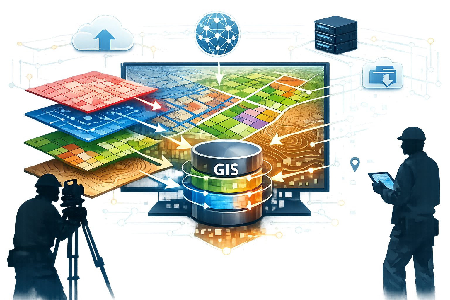
Geographic Information Systems have transformed from specialized mapping tools into comprehensive platforms that centralize, analyze, and visualize spatial data across multiple dimensions. In the context of modern surveying, GIS integration represents the strategic convergence of field data collection, cloud-based processing, and intelligent analysis within unified digital environments.
What Makes GIS Integration Essential Today
The complexity of modern construction and infrastructure projects demands more than traditional surveying deliverables. Centralized geospatial data management has become the foundation upon which successful projects are built, enabling surveyors to overlay multiple datasets including zoning information, property boundaries, utility locations, and environmental constraints in a single, comprehensive map.[1]
This integration capability addresses several critical challenges:
- Data fragmentation that historically plagued multi-disciplinary projects
- Version control issues when multiple stakeholders work with different datasets
- Communication gaps between field teams and decision-makers
- Time delays in accessing and interpreting spatial information
- Quality inconsistencies across different data sources
When conducting a Level 3 full building survey, for instance, GIS integration allows surveyors to contextualize building-specific findings within broader neighborhood patterns, historical data, and regulatory frameworks—providing clients with richer, more actionable insights.
The Evolution from Isolated Data to Integrated Ecosystems
The surveying industry has progressed through distinct technological phases. Early digital adoption focused on replacing paper maps with computer-aided design (CAD) files. While this represented progress, these files remained largely isolated from broader data ecosystems.
The next evolution introduced database-backed GIS systems that could store attributes alongside spatial features. Surveyors could query and analyze data based on characteristics beyond simple location—filtering parcels by ownership, identifying utilities by installation date, or highlighting structures by construction type.
Today's integrated approach goes further still. Common Data Environments (CDEs) have emerged as standard delivery platforms, fundamentally changing how spatial information integrates with broader project data and enabling real-time decision-making rather than relying on static plans or isolated point clouds.[4]
This shift mirrors broader industry trends. Just as measured building surveys have evolved to include rich 3D models rather than simple floor plans, GIS platforms now serve as living repositories that grow and adapt throughout project lifecycles.
Core Components of Modern GIS Integration
Effective GIS integration in surveying relies on several interconnected components:
Data Acquisition Layer
- LiDAR scanning and point cloud generation
- GPS/GNSS positioning systems
- Drone-based aerial imagery
- 360° photography for context and documentation
- Traditional total station measurements
Processing and Analysis Layer
- Cloud-based computational platforms
- AI-powered classification algorithms
- Semantic object recognition
- Quality control and validation tools
- Coordinate transformation and georeferencing
Visualization and Delivery Layer
- Interactive 3D models and digital twins
- Web-based mapping interfaces
- Mobile field applications
- Augmented reality overlays
- Traditional report generation
Integration and Interoperability Layer
- Open data format support (LAS, GeoJSON, IFC)
- API connections to external systems
- Database synchronization
- Version control and change tracking
- Security and access management
These components work together to create seamless workflows where data flows from field collection through processing and analysis to final delivery—all within integrated environments that maintain data relationships and enable sophisticated queries.
Centralizing Data: The Foundation of GIS Integration in Modern Surveying
The true power of GIS integration emerges when disparate data sources converge into centralized repositories that serve as single sources of truth. This centralization transforms how surveying organizations operate, collaborate, and deliver value.
Building Unified Geospatial Databases
Traditional surveying projects often generated isolated datasets—a topographic survey here, a utility mapping project there, boundary determinations stored separately. This fragmentation created inefficiencies and risks. Professionals wasted time searching for relevant information, stakeholders worked from outdated versions, and valuable contextual relationships remained hidden.
Unified geospatial databases address these challenges by consolidating diverse data types within structured frameworks that preserve spatial relationships while enabling flexible analysis. Modern GIS platforms support multiple data models:
| Data Model | Best For | Key Advantages |
|---|---|---|
| Vector | Boundaries, utilities, structures | Precise geometry, efficient storage, easy editing |
| Raster | Aerial imagery, elevation models, heat maps | Continuous coverage, analytical flexibility |
| Point Cloud | As-built documentation, 3D modeling | High detail, reality capture integration |
| 3D Mesh | Visualization, stakeholder communication | Photorealistic, intuitive understanding |
| Attribute Tables | Asset management, inventory tracking | Queryable characteristics, reporting capability |
The integration of these models within centralized databases enables powerful cross-referencing. A surveyor can select a building footprint (vector), view associated LiDAR scans (point cloud), examine aerial context (raster), and access construction dates and ownership records (attributes)—all from a single interface.
Organizations implementing centralized databases report significant benefits:
- ⏱️ 60-75% reduction in time spent searching for project information
- 📉 40-50% decrease in data duplication and storage costs
- ✅ 80-90% improvement in data version control accuracy
- 🤝 3-5x increase in cross-team data sharing and collaboration
Time-Series Integration and Historical Context
One of the most transformative aspects of modern GIS integration involves time-series data management—the ability to store, visualize, and analyze how spatial conditions change over time. This capability is accelerating adoption, with more organizations streaming historic layers into their GIS systems to enable predictive analytics and better forecast future conditions.[2]
Consider a municipal infrastructure management scenario. By integrating decades of survey data, maintenance records, and condition assessments, GIS platforms can reveal patterns invisible in isolated snapshots:
- Utility failure rates correlated with installation periods
- Settlement patterns in specific soil types
- Vegetation encroachment trends along right-of-ways
- Building deterioration rates by construction method
These insights enable predictive maintenance strategies that shift organizations from reactive repairs to proactive interventions—reducing costs while improving service reliability. When planning building defects surveys, access to historical data through integrated GIS systems helps identify recurring issues and assess whether observed conditions represent recent developments or long-standing concerns.
Multi-Source Data Integration Strategies
Real-world surveying projects invariably involve data from multiple sources—internal field collections, client-provided records, government databases, utility company maps, and third-party datasets. Successfully integrating these diverse inputs requires systematic approaches:
1. Standardization and Normalization
Establishing consistent coordinate systems, attribute schemas, and quality standards ensures compatibility across sources. Organizations should develop data dictionaries that define how features are classified, labeled, and attributed.
2. Quality Assessment and Validation
Not all data sources offer equal reliability. Integrated GIS platforms should include metadata tracking that documents source, collection date, accuracy specifications, and confidence levels. Automated validation routines can flag geometric errors, attribute inconsistencies, and logical conflicts.
3. Conflation and Reconciliation
When multiple sources describe the same features, conflation algorithms can merge representations while preserving the most reliable geometry and attributes. This process requires both automated tools and professional judgment to resolve discrepancies appropriately.
4. Continuous Update Mechanisms
Static integration creates new silos. Modern approaches establish data pipelines that automatically refresh GIS databases when source systems update—maintaining currency without manual intervention.
The shift toward planning-focused surveying services exemplifies why multi-source integration matters. Planning applications require coordinating survey data with zoning regulations, environmental constraints, utility easements, and community plans—all of which may originate from different agencies and systems.
Cloud-Based Platforms and Accessibility
The migration to cloud-based GIS platforms has fundamentally altered data centralization strategies. Rather than maintaining on-premises servers accessible only to office staff, organizations now deploy cloud environments that enable secure access from anywhere, on any device.
Benefits extend beyond convenience:
🌐 Universal Access: Field crews access current data on mobile devices, eliminating trips to the office for updated information
💾 Scalable Storage: Cloud infrastructure accommodates growing datasets without capital investments in hardware
🔄 Automatic Synchronization: Changes made in the field immediately appear in central databases, ensuring all stakeholders work from current information
🔒 Enterprise Security: Cloud providers implement security measures—encryption, authentication, backup, disaster recovery—that exceed most organizations' internal capabilities
⚡ Computational Power: Complex analyses that once required overnight processing complete in minutes using cloud computing resources
This accessibility transforms collaboration patterns. When conducting maintenance surveys, property managers can view findings in real-time through web browsers, asking questions and prioritizing interventions while surveyors remain on-site—accelerating decision cycles and improving outcomes.
Enhancing Decision-Making Through GIS Integration in Modern Surveying
Centralizing data creates potential; enhanced decision-making realizes value. Modern GIS integration transforms surveying from documentation services into strategic intelligence that shapes planning, design, construction, and asset management decisions.
Advanced Spatial Analysis and Insights
Traditional surveying deliverables—plans, sections, elevation certificates—presented information but left analysis to recipients. Integrated GIS platforms enable surveyors to perform sophisticated spatial analyses that directly answer decision-makers' questions:
Proximity Analysis
Identifying all properties within specified distances of proposed developments, utilities requiring relocation, or environmental features needing protection. This analysis informs impact assessments, notification requirements, and design constraints.
Viewshed and Line-of-Sight
Determining visibility from proposed structures, communication towers, or observation points. Critical for architectural review, telecommunications planning, and security applications.
Slope and Aspect Analysis
Calculating terrain characteristics that affect drainage, solar exposure, accessibility, and construction feasibility. Essential for site planning and environmental assessments.
Network Analysis
Optimizing routes for utilities, access roads, or service delivery. Minimizing construction costs while meeting operational requirements.
Suitability Modeling
Combining multiple criteria—zoning, soil types, flood zones, proximity to services—to identify optimal locations for specific uses. Supports strategic planning and investment decisions.
These analytical capabilities transform the surveyor's role from passive recorder to active advisor. When clients ask "Where should we locate this facility?" or "How will this development affect neighbors?", integrated GIS systems provide evidence-based answers rather than requiring separate consultants.
AI-Powered Semantic Awareness and Automation
Perhaps the most transformative recent development involves semantic awareness and AI integration, which have moved from experimental to mainstream. Semantic understanding of captured environments is now embedded in major software programs to automate classification, reduce manual work, and help professionals identify objects, signs, assets, and defects.[3]
Modern AI algorithms can:
- 🏗️ Classify point cloud data automatically, distinguishing buildings, vegetation, ground surfaces, utilities, and vehicles with 90%+ accuracy
- 🚧 Detect infrastructure assets including signs, poles, manholes, and pavement markings from mobile mapping data
- ⚠️ Identify defects such as cracks, spalling, corrosion, and deformation in structures and pavements
- 📏 Extract measurements automatically, generating building dimensions, clearance heights, and volumetric calculations
- 🗺️ Generate base maps from imagery, creating vector features with minimal manual digitization
This automation dramatically reduces processing time—tasks that once required days of manual classification now complete in hours. More importantly, consistency improves as algorithms apply uniform criteria rather than varying interpretations from different technicians.
The implications extend beyond efficiency. By automating routine classification, surveyors can focus expertise on complex interpretation, quality assurance, and client consultation—activities that deliver greater value and resist commoditization.
Visualization-Driven Workflows and Collaboration
Visualization-driven workflows are fundamentally transforming collaboration, with design conversations increasingly occurring directly within 3D models rather than on traditional 2D plans, enabling faster iterations and stronger alignment throughout design and construction.[4]
This shift reflects changing stakeholder expectations. Clients, community members, and approval authorities increasingly struggle to interpret traditional plans and sections. Three-dimensional visualizations—particularly when integrated with contextual imagery and interactive navigation—communicate proposals far more effectively.
Modern GIS platforms support multiple visualization approaches:
Interactive 3D Models
Stakeholders navigate proposed designs within existing contexts, adjusting viewpoints and toggling layers to understand relationships and impacts.
Augmented Reality (AR) Overlays
Mobile devices display proposed structures superimposed on real-world views, helping stakeholders visualize scale and appearance in actual settings.
Virtual Reality (VR) Immersion
Decision-makers experience designs at full scale, identifying issues and opportunities difficult to perceive in conventional representations.
Gaussian Splatting Technology
This emerging visualization approach has become mainstream, connecting point cloud precision with imagery expressiveness. Major GIS tools like ArcGIS now natively support it, representing a shift from traditional static visualizations to more lifelike 3D representations.[3]
The collaborative benefits prove substantial. Design teams identify conflicts earlier when all disciplines work within integrated 3D environments. Community engagement improves when residents can visualize proposals rather than interpreting technical drawings. Approval processes accelerate when decision-makers clearly understand what they're evaluating.
Real-Time Data and Dynamic Decision Support
Traditional surveying operated on fixed timelines—data collection occurred, processing followed, deliverables arrived weeks later. By then, site conditions may have changed, requiring resurveys and delays.
Real-time data integration transforms this paradigm. Modern workflows stream field data directly into cloud-based GIS platforms as collection occurs. Stakeholders monitor progress, identify issues, and adjust strategies while crews remain mobilized—eliminating costly remobilizations and schedule impacts.
This capability proves particularly valuable for:
Construction Monitoring
Comparing as-built conditions against design models daily, catching deviations before they compound into major issues. Integrated GIS systems overlay survey data on BIM models, highlighting discrepancies for immediate correction.
Emergency Response
Rapidly assessing damage after disasters, prioritizing response efforts, and coordinating recovery activities. Real-time data feeds support dynamic decision-making when conditions evolve rapidly.
Asset Management
Continuously updating infrastructure inventories as maintenance occurs, conditions change, and assets are added or retired. Decision-makers access current information rather than outdated records.
Quality Control
Validating field data against specifications while collection continues, allowing immediate correction of errors rather than discovering problems during office processing.
Organizations implementing real-time workflows report 25-40% reductions in project timelines and 15-25% decreases in rework costs—demonstrating the financial value of enhanced decision-making speed and quality.
Predictive Analytics and Scenario Planning
The integration of time-series data and advanced analytics enables surveying organizations to move beyond describing current conditions to forecasting future states and evaluating alternative scenarios.
Predictive models can forecast:
- Infrastructure deterioration rates based on age, materials, environmental exposure, and maintenance history
- Development impacts on traffic, utilities, and community services
- Flood risk evolution considering climate change, land use changes, and infrastructure modifications
- Vegetation growth and its effects on clearances, sight lines, and maintenance requirements
Scenario planning tools allow decision-makers to evaluate alternatives before committing resources. A municipality considering utility replacements can model different phasing approaches, comparing costs, service disruptions, and long-term performance. A developer can test site layouts against multiple criteria, optimizing for construction costs, operational efficiency, and market appeal.
These capabilities position surveyors as strategic advisors rather than tactical service providers—a distinction that supports premium positioning and deeper client relationships.
Emerging Technologies Shaping GIS Integration in Modern Surveying

The pace of technological innovation continues accelerating, with several emerging capabilities poised to further transform how GIS integration enhances surveying practice in 2026 and beyond.
Integrated Capture Approaches
Integrated capture approaches combining LiDAR and aerial imagery in a single survey are gaining adoption, reducing on-site time while providing richer context for planning and design, with growing demand for 360° imagery alongside LiDAR for added clarity and auditability.[2]
This convergence addresses a fundamental limitation of single-sensor approaches. LiDAR excels at geometric precision but lacks visual context. Photography provides intuitive imagery but limited dimensional information. Integrated systems capture both simultaneously, delivering:
- Photorealistic point clouds with true color attributes
- Accurate measurements within visually rich contexts
- Reduced field time through single-pass collection
- Comprehensive documentation supporting multiple use cases
The addition of 360° imagery has become a core component of data collection, particularly for asset management, cadastral mapping, and surveying, as it accelerates decision-making and provides stakeholder-friendly context that complements LiDAR and aerial imagery.[3]
These spherical images enable virtual site revisits—stakeholders navigate through captured environments, examining details and relationships without additional site visits. For building surveys, this capability proves invaluable when questions arise during analysis or when specialists need to examine specific features without scheduling separate inspections.
Modular Hardware and Sensor Flexibility
The surveying equipment market has historically featured proprietary systems where manufacturers tightly integrated sensors, processing software, and data formats. This approach locked users into specific ecosystems and limited flexibility.
A fundamental shift is underway. Modularity and interoperability are now essential requirements rather than optional features, with users preferring modular hardware stacks that support mixed sensors, output open-formatted data readable by external tools, and allow control over data processing and usage.[3]
Benefits of modular approaches include:
🔧 Sensor Selection: Choosing optimal sensors for specific applications rather than accepting manufacturer bundles
💰 Cost Optimization: Upgrading individual components rather than replacing entire systems
🔄 Technology Adoption: Incorporating new sensors as they emerge without abandoning existing investments
📂 Data Freedom: Accessing raw data in open formats, preventing vendor lock-in
⚙️ Processing Control: Selecting processing algorithms and parameters rather than accepting black-box outputs
This trend empowers surveying organizations to build customized collection systems optimized for their specific market niches and client requirements—a competitive advantage in increasingly specialized markets.
3D GIS and Digital Twins
While 2D GIS platforms have matured considerably, 3D GIS capabilities are now reaching similar sophistication. Modern platforms support true 3D data models where features have volumetric extent rather than being represented as 2D footprints with height attributes.
This evolution enables digital twin development—comprehensive 3D models of facilities, infrastructure networks, or entire communities that serve as platforms for analysis, simulation, and management throughout asset lifecycles.
3D GIS and asset lifecycle management are opening new opportunities for surveyors beyond traditional project boundaries, with innovations creating richer, more precise models of public assets that support real-time collaboration and smarter decision-making throughout an asset's lifecycle.[4]
Digital twins integrate diverse data sources:
- As-built survey data providing geometric foundation
- BIM models capturing design intent and component specifications
- IoT sensor feeds monitoring real-time conditions
- Maintenance records documenting interventions and performance
- Operational data revealing usage patterns and demands
This integration transforms asset management from reactive maintenance to proactive optimization. Facility managers simulate modifications before implementation, test emergency response procedures, and optimize operational parameters—all within digital environments that accurately represent physical reality.
Municipalities and infrastructure owners increasingly demand survey data that feeds comprehensive asset lifecycle management systems, driven by mounting challenges in managing vast, aging infrastructure with constrained resources.[4]
Surveyors who position themselves as digital twin enablers—providing not just initial survey data but ongoing updates and integration support—access recurring revenue streams and strategic client relationships that transcend traditional project-based engagements.
AI-Enhanced Quality Control and Validation
Quality assurance has traditionally relied on manual checks—technicians reviewing data for completeness, accuracy, and consistency. While effective, this approach proves time-consuming and subject to human error and fatigue.
AI-powered quality control systems now automate much of this process, applying sophisticated algorithms that:
- Detect geometric anomalies indicating collection errors
- Identify classification inconsistencies requiring review
- Verify completeness against project specifications
- Flag attribute errors and logical conflicts
- Compare deliverables against design models or previous surveys
These systems don't replace professional judgment but focus it on genuine issues rather than routine verification. Technicians address flagged problems rather than searching for them—improving both efficiency and quality outcomes.
Machine learning approaches continuously improve as they process more data, learning to recognize subtle indicators of problems that might escape manual review. Organizations implementing AI quality control report 30-50% reductions in delivery errors and 20-35% decreases in quality assurance time.
Spatial Analytics and Business Intelligence
The convergence of GIS platforms with business intelligence (BI) tools creates powerful analytical environments where spatial patterns inform strategic decisions across organizations.
Modern platforms support sophisticated queries combining spatial and non-spatial criteria:
- "Which assets in flood-prone areas are due for replacement within three years?"
- "What percentage of our utility network was installed before 1980 and serves high-growth neighborhoods?"
- "How many properties within 500 meters of proposed developments have submitted objections to previous projects?"
These analyses inform resource allocation, risk management, and strategic planning in ways impossible when spatial and business data remain isolated.
Spatial analytics capabilities continue evolving, with 2026 platforms offering advanced statistical methods, machine learning integration, and real-time processing that transform how organizations extract value from geospatial data.[7]
The implications extend beyond individual projects to organizational strategy. Surveying firms can analyze their project portfolios spatially, identifying geographic concentrations, underserved markets, and optimal locations for expansion. Understanding where work occurs, which clients cluster in specific regions, and how travel costs impact profitability enables data-driven business development and operational optimization.
Implementing GIS Integration: Practical Considerations
Understanding GIS integration's potential differs from successfully implementing it. Organizations pursuing integration must address technical, organizational, and cultural challenges to realize anticipated benefits.
Developing Integration Strategies
Successful GIS integration requires deliberate planning rather than ad-hoc technology adoption. Organizations should develop comprehensive strategies addressing:
Business Objectives
What specific outcomes does integration need to deliver? Improved project efficiency? Enhanced client deliverables? New service offerings? Clear objectives guide technology selection and implementation priorities.
Current State Assessment
What systems, processes, and data currently exist? Understanding starting points reveals integration challenges and opportunities. Documenting existing workflows identifies inefficiencies that integration should address.
Technology Architecture
Which platforms, tools, and standards will form the integrated environment? Decisions should balance current needs with future flexibility, favoring open standards and modular approaches over proprietary lock-in.
Data Migration and Quality
How will existing data transition into integrated systems? Legacy datasets often require cleaning, standardization, and restructuring. Underestimating this effort causes implementation delays and quality issues.
Workflow Redesign
How will integrated capabilities change work processes? Technology enables new workflows, but organizations must deliberately design and implement them. Simply digitizing existing processes rarely captures full integration benefits.
Skills and Training
What capabilities do staff need to leverage integrated systems effectively? Training programs should address both technical skills and conceptual understanding of how integration changes roles and responsibilities.
Overcoming Implementation Challenges
Organizations implementing GIS integration commonly encounter several challenges:
Data Silos and Legacy Systems
Existing data often resides in incompatible formats across disconnected systems. Breaking down these silos requires both technical integration work and organizational change management.
Resistance to Change
Staff comfortable with established workflows may resist new approaches. Successful implementations involve stakeholders early, demonstrate clear benefits, and provide adequate training and support.
Resource Constraints
Integration requires investment in technology, training, and process redesign. Organizations must balance implementation costs against anticipated benefits, potentially phasing adoption to spread investments over time.
Technical Complexity
Modern GIS platforms offer extensive capabilities that can overwhelm new users. Starting with core functionality and progressively expanding usage prevents paralysis and builds confidence.
Data Quality Issues
Integration exposes quality problems previously hidden in isolated datasets. Organizations should view this as an opportunity to improve data quality rather than an implementation barrier.
Addressing these challenges requires committed leadership, adequate resources, and realistic timelines. Organizations should expect 12-24 months for comprehensive integration implementations, with benefits emerging progressively rather than immediately.
Building Collaborative Ecosystems
GIS integration's full value emerges when it extends beyond individual organizations to encompass project teams, clients, and stakeholders. Building these collaborative ecosystems requires:
Common Data Environments (CDEs)
Establishing shared platforms where all project participants access current information, contribute updates, and coordinate activities. CDEs should support appropriate access controls while maximizing information sharing.
Interoperability Standards
Adopting industry standards for data formats, exchange protocols, and classification systems ensures compatibility across organizations using different platforms.
Contractual Frameworks
Updating agreements to address data ownership, sharing responsibilities, quality standards, and liability issues in integrated environments. Traditional contracts often assume isolated deliverables rather than shared data ecosystems.
Communication Protocols
Establishing clear processes for how stakeholders interact through integrated platforms—notification of updates, issue resolution procedures, approval workflows, and documentation requirements.
Organizations leading collaborative integration efforts often gain strategic advantages, positioning themselves as preferred partners for clients seeking coordinated, efficient project delivery.
Measuring Success and Continuous Improvement
Implementing GIS integration represents significant investment. Organizations should establish metrics demonstrating value and guiding continuous improvement:
Efficiency Metrics
- Time from data collection to deliverable completion
- Labor hours per project or deliverable unit
- Rework frequency and associated costs
- Data search and retrieval time
Quality Metrics
- Error rates in deliverables
- Client satisfaction scores
- Revision requests per project
- Compliance with specifications and standards
Business Metrics
- Revenue per employee
- Project profit margins
- Client retention rates
- New service adoption
Strategic Metrics
- Market share in target segments
- Competitive win rates
- Innovation pipeline development
- Staff satisfaction and retention
Regular review of these metrics reveals integration's impact and identifies opportunities for further optimization. Successful organizations treat GIS integration as ongoing evolution rather than one-time implementation.
The Future of GIS Integration in Modern Surveying
As 2026 progresses, several trends will shape how GIS integration continues transforming surveying practice and expanding professional opportunities.
Expanding Applications and Market Opportunities
Reality capture integration into project management workflows is becoming standard practice, allowing surveyors to document conditions, visually track progress, and collaborate on solutions in real time enhanced by AI and cloud-based platforms. Clients increasingly expect rich digital deliverables beyond traditional survey products.[4]
This expectation creates opportunities for surveyors to expand service offerings:
Ongoing Monitoring Services
Rather than one-time surveys, providing continuous monitoring through periodic data collection and automated change detection. Particularly valuable for infrastructure management, construction progress tracking, and environmental compliance.
Consulting and Advisory Services
Leveraging integrated data to provide strategic advice on development feasibility, asset optimization, risk management, and regulatory compliance. Moving beyond data provision to interpretation and recommendation.
Data Management Services
Managing clients' geospatial data repositories, ensuring quality, currency, and accessibility. Particularly appealing to organizations lacking internal GIS expertise but recognizing spatial data's strategic value.
Training and Support
Helping clients develop internal capabilities to leverage integrated GIS platforms effectively. Creating ongoing relationships rather than transactional project engagements.
These expanded services support business model evolution from project-based fees to recurring revenue relationships—improving financial stability and client retention.
Workforce Development and Skill Requirements
The shift toward integrated, technology-enabled surveying creates evolving workforce requirements. What employers are really looking for in GIS candidates in 2026 includes both technical proficiency and broader capabilities:[9]
Technical Skills
- GIS platform expertise (ArcGIS, QGIS, etc.)
- Data analysis and spatial statistics
- Programming and automation (Python, SQL)
- Reality capture technologies (LiDAR, photogrammetry)
- CAD and BIM software proficiency
Analytical Skills
- Problem-solving and critical thinking
- Data interpretation and visualization
- Quality assurance and validation
- Project planning and management
Communication Skills
- Client consultation and needs assessment
- Stakeholder engagement and collaboration
- Technical documentation and reporting
- Visual communication and presentation
Business Acumen
- Understanding client industries and challenges
- Project economics and value demonstration
- Market trends and competitive positioning
- Service development and innovation
Organizations should invest in continuous learning programs that develop these capabilities, recognizing that technology evolution requires ongoing skill development rather than one-time training.
Regulatory and Standards Development
As GIS integration becomes standard practice, regulatory frameworks and industry standards are evolving to address new capabilities and expectations.
Data quality standards are becoming more sophisticated, moving beyond simple accuracy specifications to address completeness, currency, consistency, and fitness for purpose across integrated datasets.
Interoperability requirements are appearing in project specifications, with clients demanding data in open formats compatible with their systems rather than accepting proprietary deliverables.
Digital delivery standards are replacing traditional plan-based specifications, defining requirements for 3D models, metadata, classification systems, and data structures.
Liability frameworks are adapting to integrated environments where multiple parties contribute to shared datasets and decisions rely on combined information from various sources.
Surveyors should engage with standards development organizations and professional associations to help shape these evolving frameworks, ensuring they reflect practical realities and support innovation rather than constraining it.
Sustainability and Social Responsibility
GIS integration supports broader sustainability objectives by enabling more efficient resource use, better-informed planning, and proactive infrastructure management.
Environmental applications include habitat mapping, climate change impact assessment, renewable energy siting, and conservation planning—all areas where integrated spatial analysis provides crucial insights.
Social equity considerations benefit from spatial analysis revealing disparities in infrastructure quality, service access, and environmental exposures across communities. This information supports more equitable resource allocation and policy development.
Economic sustainability improves through optimized infrastructure investment, reduced waste, and extended asset lifecycles enabled by data-driven management.
Surveyors embracing these applications position themselves as contributors to community resilience and sustainable development—roles that resonate with both clients and emerging professionals seeking meaningful work.
Conclusion

GIS Integration in Modern Surveying: Centralizing Data and Enhancing Decision-Making represents far more than technological advancement—it fundamentally redefines the surveying profession's role and value proposition. By centralizing diverse datasets within unified platforms, enabling sophisticated spatial analysis, and supporting visualization-driven collaboration, integrated GIS systems transform surveyors from documentation specialists into strategic advisors whose insights shape communities and infrastructure.
The technologies driving this transformation—AI-powered automation, cloud-based collaboration, real-time data streaming, and immersive visualization—have matured from experimental capabilities to mainstream expectations. Organizations that embrace integration position themselves to deliver unprecedented value, access expanding market opportunities, and build sustainable competitive advantages.
Actionable Next Steps
For surveying organizations and professionals seeking to advance their GIS integration capabilities, consider these concrete actions:
Assess Current State
Conduct honest evaluation of existing systems, workflows, and capabilities. Identify gaps between current state and integration objectives. Document pain points that integration should address.
Develop Integration Roadmap
Create phased implementation plan balancing quick wins with long-term transformation. Prioritize initiatives based on business impact and implementation feasibility. Establish clear success metrics.
Invest in Core Platforms
Select GIS platforms supporting current needs while providing growth capacity. Prioritize open standards, cloud capabilities, and modular architectures. Avoid proprietary lock-in.
Build Team Capabilities
Implement comprehensive training programs developing both technical skills and conceptual understanding. Create learning culture supporting continuous development. Consider hiring specialists to accelerate capability building.
Start Collaborative Pilots
Initiate integration projects with progressive clients willing to explore new approaches. Use pilots to demonstrate value, refine workflows, and build case studies. Scale successful approaches across broader client base.
Engage Industry Evolution
Participate in professional associations, standards development, and knowledge sharing. Stay informed about emerging technologies and evolving best practices. Contribute to profession's advancement.
Measure and Optimize
Establish metrics tracking integration's impact on efficiency, quality, and business performance. Regularly review results and adjust strategies. Celebrate successes and learn from challenges.
The surveying profession stands at a pivotal moment. Those who embrace GIS integration's transformative potential will lead the industry's evolution, delivering exceptional value while building resilient, future-focused practices. The question isn't whether to integrate, but how quickly and comprehensively to pursue the opportunities integration creates.
The future of surveying is integrated, intelligent, and indispensable. The journey begins today.
References
[1] The Future Of Land Surveying Technology And Upcoming Trends In 2026 – https://metricop.com/blogs/land-surveying/the-future-of-land-surveying-technology-and-upcoming-trends-in-2026
[2] Geospatial Trends 2026 – https://www.getmapping.co.uk/geospatial-trends-2026/
[3] 6 Geospatial Trends To Watch In 2026 Insights From Intergeo 2025 – https://www.mosaic51.com/community/6-geospatial-trends-to-watch-in-2026-insights-from-intergeo-2025/
[4] Doubling Down On Digital – https://amerisurv.com/2026/02/01/doubling-down-on-digital/
[5] Evolution Of Gis Mapping Trends Technologies 2026 – https://asecaddesign.com/blogs/evolution-of-gis-mapping-trends-technologies-2026/
[6] 5 Planning Trends 2026 – https://www.esri.com/en-us/industries/blog/articles/5-planning-trends-2026
[7] Spatial Analytics In 2026 Whats Changing – https://carto.com/blog/spatial-analytics-in-2026-whats-changing
[8] Us Dot Gis Strategic Plan 2026 30 – https://www.transportation.gov/sites/dot.gov/files/2025-12/US-DOT-GIS-Strategic-Plan-2026-30.pdf
[9] What Employers Are Really Looking For In Gis Candidates In 2026 – https://www.geoconnexion.com/in-depth/what-employers-are-really-looking-for-in-gis-candidates-in-2026