The land surveying industry has witnessed a remarkable revolution over the past decade, but 2026 marks a pivotal moment in this transformation. What was once considered an expensive luxury reserved for large-scale operations has evolved into an accessible, cost-effective standard practice. How Drones Are Transforming Land Surveying: Cost Reduction and Accessibility in 2026 represents more than just technological advancement—it signals a fundamental shift in how professionals approach spatial data collection, project planning, and site analysis. Unmanned Aerial Vehicles (UAVs) have democratized precision surveying, enabling small firms and independent professionals to deliver results that rival traditional methods at a fraction of the cost and time investment.
The journey from ground-based theodolites to autonomous aerial systems has been nothing short of extraordinary. Today's surveying drones equipped with advanced sensors, Real-Time Kinematic (RTK) positioning, and sophisticated photogrammetry software can accomplish in hours what traditional crews required weeks to complete. This dramatic efficiency gain, combined with plummeting equipment costs and simplified operation, has made drone surveying the new industry standard across construction, infrastructure development, environmental monitoring, and property assessment sectors.
Key Takeaways
- 🚁 Dramatic Time Savings: Modern drone surveys complete in hours what traditional ground-based methods require days or weeks to accomplish, with comprehensive surface coverage and minimal manual effort
- 💰 Significant Cost Reduction: While initial investment remains substantial, operational costs for drone surveying are markedly lower than conventional approaches, with fewer personnel required and reduced equipment expenses
- 📊 Centimeter-Level Precision: Advanced RTK/PPK positioning systems deliver measurements accurate to within centimeters for heights, distances, and volumes, matching or exceeding traditional surveying accuracy
- 🌍 Enhanced Accessibility: Drones provide unprecedented access to challenging terrain, hazardous locations, and hard-to-reach areas while eliminating ground personnel safety risks
- 🔄 Seamless Digital Integration: Drone survey data integrates directly into digital platforms, CAD software, and Building Information Modeling (BIM) systems, streamlining workflows and enabling real-time collaboration
The Evolution from Luxury to Standard Practice
The Traditional Surveying Landscape
Before understanding how drones are transforming land surveying in 2026, it's essential to recognize the limitations of conventional methods. Traditional land surveying relied heavily on ground-based equipment including total stations, theodolites, and GPS receivers. Survey crews would physically traverse terrain, establishing control points and taking measurements one location at a time. This labor-intensive process presented several challenges:
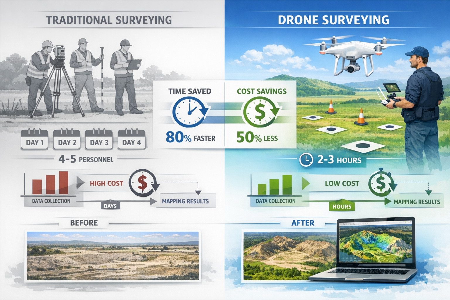
Time-consuming operations required teams to spend days or weeks on-site, particularly for large parcels or complex topography. Each measurement point demanded careful setup, calibration, and recording, creating bottlenecks in project timelines.
High labor costs accumulated quickly as multiple skilled professionals were needed for extended periods. Survey crews typically consisted of at least two to three people, with senior surveyors commanding premium rates for their expertise.
Limited coverage meant that comprehensive site documentation often proved impractical. Traditional methods captured data at discrete points rather than continuous surfaces, potentially missing important features between measurement locations.
Safety concerns were paramount when surveying hazardous terrain, active construction sites, or areas with unstable ground conditions. Surveyors faced exposure to traffic, extreme weather, and physical dangers inherent in accessing remote or challenging locations[2].
The Drone Revolution Begins
The introduction of commercial drone technology in the early 2010s sparked initial interest, but early systems carried prohibitive price tags often exceeding £50,000 for professional-grade equipment. Regulatory uncertainty, limited battery life, and complex operation requirements restricted adoption to well-funded organizations willing to invest in specialized training and equipment.
However, the landscape shifted dramatically between 2020 and 2026. Several converging factors accelerated drone adoption across the surveying industry:
Technological maturation brought increasingly sophisticated sensors, longer flight times, and more intuitive control systems. Modern surveying drones feature obstacle avoidance, automated flight planning, and one-touch operation that reduces the learning curve significantly[1].
Regulatory clarity emerged as aviation authorities worldwide established clear frameworks for commercial drone operations. In the UK, the Civil Aviation Authority's streamlined certification processes made it easier for surveying professionals to obtain necessary permissions.
Cost reduction transformed the economic equation entirely. Entry-level professional surveying drones now start around £3,000-£5,000, with complete systems including processing software available for £10,000-£15,000—a fraction of traditional equipment costs[3].
Software advancement revolutionized data processing. Photogrammetry and LiDAR processing platforms evolved from specialized tools requiring expert knowledge to user-friendly applications with automated workflows and cloud-based processing capabilities[2].
How Drones Are Transforming Land Surveying Through Cost Reduction
Breaking Down the Financial Transformation
The economic impact of drone technology on land surveying extends far beyond simple equipment costs. Understanding How Drones Are Transforming Land Surveying: Cost Reduction and Accessibility in 2026 requires examining the complete financial picture across multiple dimensions.
Initial Investment Comparison
| Equipment Type | Traditional Surveying | Drone Surveying |
|---|---|---|
| Primary Equipment | £15,000-£40,000 (Total Station/RTK GPS) | £3,000-£25,000 (Professional UAV) |
| Supporting Tools | £5,000-£10,000 (Prisms, poles, accessories) | £1,000-£3,000 (Batteries, cases, tablets) |
| Software Licenses | £2,000-£5,000 annually | £1,500-£4,000 annually |
| Training & Certification | £3,000-£8,000 per surveyor | £1,000-£2,500 per operator |
| Total Initial Investment | £25,000-£63,000 | £6,500-£34,500 |
The initial capital requirements clearly favor drone-based approaches, particularly for smaller firms and independent professionals entering the market. This accessibility has democratized precision surveying, enabling practitioners who previously couldn't afford traditional equipment to deliver professional-grade results.
Operational Cost Advantages
Beyond initial investment, operational efficiency drives the most significant cost reductions. Drones fundamentally alter the resource equation for surveying projects:
Personnel requirements drop dramatically. A traditional survey crew of three to four people can be replaced by a single drone operator, with occasional assistance for ground control point placement. This reduction in labor costs compounds over time, particularly for firms conducting regular surveys[3].
Project duration shrinks from days or weeks to hours. A 50-acre site that might require a traditional crew five days to survey can be captured by drone in two to three hours of flight time. The compressed timeline reduces not only direct labor costs but also indirect expenses like accommodation, transportation, and equipment rental.
Equipment maintenance costs remain minimal for drone systems compared to traditional surveying equipment. While drones require periodic battery replacement and occasional repairs, these expenses pale compared to the calibration, maintenance, and replacement costs associated with total stations and GPS receivers.
Data collection efficiency multiplies productivity exponentially. Drones capture thousands of data points during each flight, creating comprehensive point clouds and high-resolution imagery that would be impractical to obtain through traditional methods[2]. This density of information provides greater value without proportional cost increases.
Real-World Cost Reduction Examples
Consider a typical topographic survey for a 10-hectare development site:
Traditional Method:
- Survey crew: 3 people × 4 days = 12 person-days
- Labor cost: £2,400-£3,600 (at £200-£300 per person-day)
- Equipment: £400-£600 (rental/depreciation)
- Transportation & expenses: £300-£500
- Total: £3,100-£4,700
Drone Method:
- Operator: 1 person × 1 day = 1 person-day
- Labor cost: £300-£500
- Equipment: £100-£150 (depreciation/battery costs)
- Processing time: 4-6 hours (largely automated)
- Total: £400-£650
The cost savings exceed 85% while delivering comparable or superior data quality. For surveying firms conducting multiple projects monthly, these savings accumulate to hundreds of thousands of pounds annually, fundamentally altering business economics and competitive positioning.
Firms offering premium drone surveys can now provide comprehensive site documentation at price points that make professional surveying accessible to smaller development projects and property owners who previously couldn't justify the expense.
Accessibility Revolution: Democratizing Professional Surveying
Geographic and Terrain Accessibility
One of the most profound ways How Drones Are Transforming Land Surveying: Cost Reduction and Accessibility in 2026 manifests is through expanded geographic reach. Drones have eliminated traditional barriers that made certain surveying projects impractical or impossible:
Challenging topography no longer presents insurmountable obstacles. Steep hillsides, rocky outcrops, dense vegetation, and unstable ground that would endanger survey crews or require expensive specialized access can now be surveyed safely from the air. This capability has opened new possibilities for infrastructure development, environmental monitoring, and natural resource management[3].
Hazardous locations including active construction sites, contaminated areas, and structurally compromised buildings can be thoroughly documented without exposing personnel to danger. The ability to collect detailed measurements while maintaining safe distances has transformed risk management in surveying operations[2].
Remote areas become economically viable to survey. Previously, the cost of transporting crews and equipment to distant locations made small-scale surveys prohibitively expensive. Compact drone systems can be transported easily, enabling cost-effective surveying in locations where traditional methods would require substantial logistical investment.
Vertical structures and elevated features receive comprehensive documentation. Drones excel at capturing facades, rooflines, towers, and other vertical elements that traditional ground-based surveying struggles to measure accurately. This capability proves invaluable for building materials assessments and structural evaluations.
Professional Accessibility and Market Entry
The accessibility transformation extends beyond physical geography to professional opportunity. Drone technology has lowered barriers to entry for surveying services:
Smaller firms compete effectively with established players by leveraging drone technology to deliver comparable results without the overhead of traditional equipment and large crews. This leveling of the competitive landscape has increased market competition and innovation.
Specialized practitioners can offer surveying services alongside their primary expertise. Architects, engineers, construction managers, and property professionals can incorporate surveying capabilities into their service offerings without maintaining dedicated survey departments.
Geographic expansion becomes feasible for regional firms. The portability and efficiency of drone systems enable surveyors to serve wider territories without establishing physical offices or maintaining local crews in each market.
Service diversification allows surveying professionals to expand into adjacent markets. The same drone system used for topographic surveys can support environmental assessments, progress monitoring, volumetric calculations, and thermal inspections, creating multiple revenue streams from a single technology investment.
Knowledge and Training Accessibility
The learning curve for drone surveying has become remarkably accessible compared to traditional surveying education:
Accelerated training programs enable professionals to achieve operational competency in weeks rather than the years required for traditional surveying mastery. While deep expertise still requires experience, basic proficiency comes quickly[1].
Online resources provide extensive educational materials, tutorials, and community support. Drone manufacturers, software developers, and professional organizations offer training programs ranging from beginner fundamentals to advanced techniques.
Lower certification barriers make it easier to obtain necessary credentials. While professional surveying licenses still require substantial education and experience, drone operation certifications focus on aviation safety and can be achieved relatively quickly.
Intuitive interfaces in modern flight planning and processing software reduce technical complexity. Automated workflows guide operators through mission planning, data capture, and processing, minimizing the specialized knowledge required for successful surveys.
Technical Capabilities Driving the Transformation
Precision and Accuracy in Modern Drone Surveying
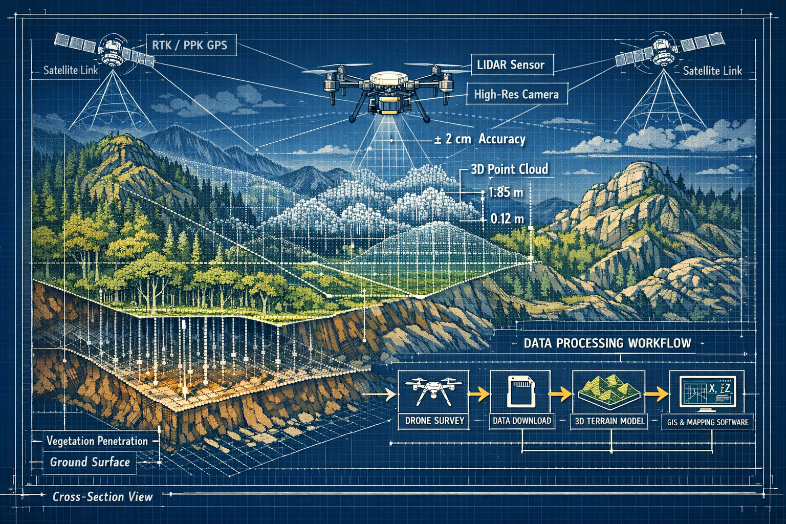
A common misconception suggests that drone surveys sacrifice accuracy for convenience. In reality, modern systems achieve centimeter-level precision that matches or exceeds traditional surveying methods when properly implemented[2].
RTK and PPK Positioning Systems
The accuracy revolution stems from advanced positioning technologies:
Real-Time Kinematic (RTK) systems receive correction signals from ground-based reference stations during flight, enabling the drone to determine its position with centimeter-level accuracy in real-time. This eliminates the need for extensive ground control points, dramatically reducing field time and labor requirements.
Post-Processed Kinematic (PPK) systems record raw positioning data during flight and apply corrections during post-processing. PPK offers similar accuracy to RTK while providing greater flexibility and reliability in areas with challenging radio signal conditions.
These positioning technologies enable drones to achieve:
- Horizontal accuracy: ±1-3 centimeters
- Vertical accuracy: ±2-5 centimeters
- Volumetric calculations: ±0.5-1% of total volume
Such precision meets or exceeds requirements for most surveying applications, from construction layout to cadastral boundary determination.
LiDAR Technology Integration
Light Detection and Ranging (LiDAR) systems represent another breakthrough in drone surveying capabilities. LiDAR-equipped drones emit laser pulses and measure return times to create extraordinarily detailed three-dimensional point clouds[3].
LiDAR's transformative advantages include:
🌲 Vegetation penetration: Laser pulses penetrate forest canopy and dense vegetation to reveal ground surface beneath, enabling accurate terrain modeling in heavily wooded areas where photogrammetry fails.
🏗️ Complex structure capture: LiDAR excels at documenting intricate architectural features, industrial facilities, and infrastructure with millimeter-level detail, supporting precise as-built documentation.
🌙 Low-light operation: Unlike camera-based systems requiring adequate lighting, LiDAR functions effectively in dawn, dusk, or overcast conditions, expanding operational windows.
⚡ Rapid data collection: LiDAR systems capture hundreds of thousands of points per second, creating dense point clouds that reveal subtle terrain variations and structural details.
The archaeological community has leveraged LiDAR drones to discover ancient sites hidden beneath jungle canopy—structures invisible to traditional surveying methods. This same capability benefits infrastructure planning, forestry management, and environmental monitoring across diverse applications[3].
Sensor Diversity and Multi-Modal Data Collection
Modern surveying drones function as versatile platforms supporting multiple sensor types:
High-resolution RGB cameras capture detailed imagery for photogrammetric processing, creating orthomosaic maps and 3D models with photographic texture and color information.
Multispectral sensors record data across multiple spectral bands, enabling vegetation health analysis, crop monitoring, and environmental assessment applications that extend beyond traditional surveying.
Thermal cameras detect temperature variations across surfaces, supporting building envelope analysis, solar panel inspection, and infrastructure condition assessment.
Hyperspectral sensors on advanced platforms capture data across dozens of narrow spectral bands, enabling material identification and detailed surface composition analysis.
This sensor diversity allows single platforms to serve multiple purposes, maximizing return on investment and expanding service offerings for surveying professionals.
Data Processing and Digital Workflow Integration
The transformation extends beyond data capture to encompass the entire surveying workflow. Modern drone surveying represents a fully digital process from flight planning through final deliverable production[2].
Automated processing workflows convert raw imagery and sensor data into actionable deliverables with minimal manual intervention. Photogrammetry software automatically identifies matching features across images, calculates camera positions, and generates point clouds, orthomosaics, and 3D models.
Cloud-based platforms enable processing of large datasets without substantial local computing infrastructure. Survey data uploads to cloud servers where powerful processing engines generate results, then delivers finished products through web-based interfaces accessible from any device.
Direct CAD integration allows processed survey data to flow seamlessly into design software. Point clouds and terrain models import directly into AutoCAD, Civil 3D, Revit, and other engineering platforms, eliminating time-consuming manual data transfer and reducing transcription errors.
Collaborative platforms support real-time sharing of survey data among project stakeholders. Clients, designers, contractors, and regulatory authorities can access current survey information through web browsers, improving coordination and decision-making throughout project lifecycles.
This digital integration creates efficiency gains that compound the time and cost savings achieved during data collection. What once required days of office processing now completes in hours, with results immediately available to all project participants.
Practical Implementation: Making the Transition
Selecting Appropriate Drone Systems
For professionals considering how to leverage How Drones Are Transforming Land Surveying: Cost Reduction and Accessibility in 2026, equipment selection represents a critical first step. The market offers systems spanning a wide range of capabilities and price points:
Entry-Level Professional Systems (£3,000-£8,000)
These platforms suit small surveying firms, independent professionals, and those beginning drone surveying operations:
Characteristics:
- High-resolution cameras (20+ megapixels)
- GPS positioning (±1-5 meter accuracy without ground control)
- 20-30 minute flight times
- Obstacle avoidance sensors
- Automated flight planning
- Photogrammetry-capable
Ideal applications:
- Small to medium site surveys (under 50 acres)
- Visual documentation and inspection
- Basic topographic mapping
- Progress monitoring
- Property boundary documentation
Limitations:
- Require ground control points for high accuracy
- Limited payload capacity
- Basic positioning accuracy
- Consumer-grade build quality
Mid-Range Professional Systems (£8,000-£20,000)
These represent the sweet spot for established surveying practices:
Characteristics:
- RTK/PPK positioning systems
- Interchangeable payloads
- 30-45 minute flight times
- Advanced obstacle avoidance
- Professional-grade construction
- Centimeter-level accuracy capability
Ideal applications:
- Large-scale topographic surveys
- Construction site documentation
- Infrastructure corridor mapping
- Volumetric calculations
- Cadastral surveys
- Engineering-grade deliverables
Advantages:
- Reduced ground control requirements
- Survey-grade accuracy
- Versatile payload options
- Reliable performance
- Comprehensive manufacturer support
Advanced LiDAR Systems (£20,000-£60,000+)
These specialized platforms serve demanding applications requiring maximum accuracy and capability:
Characteristics:
- Integrated LiDAR sensors
- Survey-grade GNSS/IMU systems
- Multiple simultaneous sensors
- Extended flight times (45+ minutes)
- Industrial-grade construction
- Millimeter-level accuracy potential
Ideal applications:
- Dense vegetation terrain modeling
- Complex structure documentation
- Utility corridor mapping
- Mining and quarry surveys
- Archaeological surveys
- High-precision engineering projects
Considerations:
- Substantial initial investment
- Specialized training requirements
- Complex data processing
- Higher operational costs
- Regulatory compliance complexity
Understanding project requirements, budget constraints, and growth plans helps determine the appropriate system level. Many successful firms begin with mid-range platforms that deliver professional results while maintaining reasonable investment levels, then expand capabilities as demand justifies.
Building Operational Competency
Equipment acquisition represents only the beginning of successful drone surveying implementation. Developing operational competency requires attention to several key areas:
Regulatory Compliance
Operating commercial drones for surveying requires adherence to aviation regulations:
Operator certification: In the UK, commercial drone operators must obtain a General Visual Line of Sight Certificate (GVC) through approved training organizations. This involves both theoretical knowledge testing and practical flight assessment.
Operational permissions: Depending on flight locations and circumstances, additional permissions may be required from the Civil Aviation Authority, particularly for operations near airports, over congested areas, or beyond visual line of sight.
Insurance coverage: Professional liability and hull insurance protect against potential damages and equipment loss. Surveying-specific policies address unique risks associated with professional data collection services.
Data protection: Survey data often includes sensitive information requiring compliance with GDPR and data protection regulations, particularly when documenting private property or collecting personal information.
Flight Planning and Execution
Effective drone surveying demands systematic flight planning:
Mission design determines flight altitude, overlap percentages, and camera settings to ensure adequate data capture. Most surveying applications require 70-80% forward overlap and 60-70% side overlap between images to enable accurate photogrammetric processing.
Ground control establishment remains important even with RTK/PPK systems for maximum accuracy. Strategic placement of surveyed control points enables verification of positional accuracy and refinement of processing results.
Weather assessment ensures safe operations and quality data collection. Wind speed, precipitation, lighting conditions, and temperature all impact flight safety and data quality.
Safety protocols protect personnel, equipment, and bystanders. Pre-flight checklists, emergency procedures, and airspace awareness prevent incidents and ensure professional operations.
Data Processing Proficiency
Transforming raw flight data into useful deliverables requires processing expertise:
Software selection depends on project requirements, budget, and technical capabilities. Leading photogrammetry platforms include Pix4D, Agisoft Metashape, DroneDeploy, and others, each offering different features and workflows.
Quality control ensures deliverables meet accuracy specifications. Processing reports, ground control residuals, and checkpoint verification confirm that results satisfy project requirements before delivery to clients.
Deliverable production converts processed data into client-usable formats. Common outputs include orthomosaic imagery, digital elevation models, contour maps, point clouds, 3D models, and volumetric calculations.
Workflow optimization streamlines operations through standardized procedures, processing templates, and automated routines that reduce manual effort and improve consistency.
Many surveying professionals find that processing expertise develops through practice and experimentation. Starting with straightforward projects builds confidence and competency before tackling complex assignments.
Integration with Existing Services
For established surveying practices, drones complement rather than replace traditional capabilities. Successful integration leverages the strengths of each approach:
Hybrid methodologies combine drone aerial data with ground-based measurements for optimal results. Drones provide comprehensive surface coverage while traditional equipment establishes precise control networks and captures details in areas where aerial data proves insufficient.
Service expansion allows firms to offer enhanced capabilities to existing clients. Adding drone surveys to traditional offerings like Level 3 building surveys provides comprehensive property documentation that addresses both structural assessment and site context.
Efficiency improvements accelerate project delivery across all service lines. Rapid drone-based site documentation supports faster project initiation, reducing overall timeline from initial survey through final deliverables.
Competitive differentiation positions firms as technology leaders adopting innovative approaches. Marketing drone capabilities attracts clients seeking modern, efficient service delivery while demonstrating commitment to continuous improvement.
Understanding the difference between survey levels helps determine where drone technology adds the most value within a comprehensive service portfolio.
Industry Applications and Use Cases
Construction and Development
The construction sector has embraced drone surveying as an essential tool throughout project lifecycles:
Pre-construction surveying establishes baseline conditions, documents existing features, and creates accurate terrain models for design development. Drones capture comprehensive site data in a fraction of the time required by traditional methods, accelerating project initiation.
Progress monitoring tracks construction advancement through regular aerial surveys. Comparing sequential datasets reveals work completed, identifies deviations from plans, and supports accurate progress billing. This application has become particularly valuable for large-scale developments where traditional monitoring proves labor-intensive.
Volumetric calculations determine earthwork quantities for cut-and-fill operations. Drone-derived digital elevation models enable precise volume calculations for stockpiles, excavations, and grading operations, supporting cost control and material management.
As-built documentation creates permanent records of completed construction. High-resolution imagery and 3D models capture final conditions, supporting facility management, future renovations, and regulatory compliance.
Safety inspections enable regular monitoring of construction sites without exposing personnel to hazards. Aerial perspectives reveal safety concerns, housekeeping issues, and compliance problems that may not be apparent from ground level.
Infrastructure and Utilities
Infrastructure owners and operators leverage drone surveying for asset management and planning:
Corridor mapping documents linear infrastructure including roads, railways, pipelines, and transmission lines. Drones efficiently survey long, narrow corridors that prove time-consuming for traditional methods, creating comprehensive records for planning and maintenance.
Bridge inspection captures detailed imagery of structural elements without requiring expensive access equipment or traffic closures. High-resolution photography reveals deterioration, damage, and defects requiring attention, supporting preventive maintenance programs.
Power line inspection identifies vegetation encroachment, equipment defects, and structural issues along transmission and distribution networks. Thermal imaging detects hot spots indicating electrical problems before failures occur.
Drainage assessment documents watershed characteristics, identifies erosion issues, and supports stormwater management planning. Accurate terrain modeling enables hydraulic analysis and infrastructure design.
Environmental and Natural Resources
Environmental professionals employ drone surveying for monitoring and assessment:
Habitat mapping documents vegetation communities, wetland boundaries, and wildlife corridors. Multispectral imagery enables species identification and health assessment across large areas.
Erosion monitoring tracks shoreline changes, riverbank stability, and land loss over time. Sequential surveys reveal erosion rates and support mitigation planning.
Mine reclamation monitors restoration progress on former mining sites. Volumetric analysis tracks material placement while vegetation indices assess revegetation success.
Forest management supports timber inventory, harvest planning, and reforestation monitoring. LiDAR penetration through canopy enables accurate terrain modeling and tree height measurement in forested areas.
Property and Real Estate
Property professionals utilize drone surveying for documentation and marketing:
Boundary surveys establish property limits and identify encroachments. While ground-based measurements remain necessary for legal boundary determination, aerial imagery provides valuable context and reveals features affecting property use.
Property marketing creates compelling aerial photography and videography that showcases properties from unique perspectives. Drone imagery has become standard in high-end real estate marketing, providing buyers with comprehensive property understanding.
Condition assessment supports building problems identification by documenting roof conditions, structural issues, and site characteristics without requiring physical access to all areas.
Valuation support provides appraisers and valuers with comprehensive property documentation. Accurate site measurements, building footprints, and contextual imagery support insurance reinstatement cost valuations and other valuation assignments.
Future Developments and Emerging Trends

Autonomous Operations and Swarm Technology
The evolution of How Drones Are Transforming Land Surveying: Cost Reduction and Accessibility in 2026 continues accelerating with emerging autonomous capabilities:
Swarm coordination enables multiple drones to work collaboratively on large surveying projects with minimal human intervention. Coordinated flight paths optimize coverage while avoiding collisions, dramatically increasing area coverage per operational day[1].
Automated mission execution allows drones to conduct surveys with limited operator involvement. Pre-programmed missions execute automatically, with drones navigating obstacles, adjusting to conditions, and returning for battery changes without constant manual control.
AI-powered flight planning optimizes survey parameters based on project requirements, terrain characteristics, and environmental conditions. Machine learning algorithms determine ideal flight altitudes, camera settings, and overlap percentages to ensure quality data capture.
Adaptive surveying enables drones to adjust missions in real-time based on conditions encountered. If initial passes reveal areas requiring additional detail, autonomous systems can modify flight plans to capture supplementary data without operator intervention.
These autonomous capabilities promise further efficiency gains and cost reductions as they mature and gain regulatory approval for commercial operations.
Enhanced Processing and Analysis
Data processing continues evolving with artificial intelligence and machine learning integration:
Automated feature extraction identifies and classifies objects within survey data. AI algorithms recognize buildings, vegetation, vehicles, infrastructure, and other features, automatically generating GIS-ready vector data from raw imagery.
Change detection compares sequential surveys to highlight modifications, supporting construction monitoring, environmental assessment, and asset management. Automated algorithms identify differences between datasets, eliminating manual comparison.
Predictive analytics leverages historical survey data to forecast future conditions. Machine learning models predict erosion progression, vegetation growth, and infrastructure deterioration, supporting proactive management.
Real-time processing delivers preliminary results during or immediately after data collection. Edge computing and improved algorithms enable field verification of data quality and coverage, reducing the need for return visits.
Regulatory Evolution
Aviation authorities worldwide continue refining drone regulations to balance safety with operational flexibility:
Beyond visual line of sight (BVLOS) operations will become more accessible as regulatory frameworks mature. BVLOS capability enables surveying of linear infrastructure and large areas without maintaining visual contact, dramatically expanding operational efficiency.
Urban operations will see expanded permissions as detect-and-avoid technology proves reliable. Surveying in populated areas currently faces restrictions that emerging technology and regulatory evolution will gradually relax.
Automated operations will gain regulatory acceptance as safety records demonstrate reliability. Reduced operator involvement will further decrease costs while maintaining or improving safety performance.
Integration with Emerging Technologies
Drone surveying increasingly integrates with complementary technologies:
Digital twins leverage drone survey data to create virtual replicas of physical assets. Regular drone surveys update digital twins with current conditions, supporting predictive maintenance and operational optimization.
Building Information Modeling (BIM) incorporates drone-captured as-built data throughout construction and facility management lifecycles. Seamless integration between survey data and BIM platforms improves coordination and reduces errors.
Augmented reality (AR) overlays drone survey data onto real-world views through mobile devices and AR glasses. Field personnel can visualize underground utilities, compare as-built to design, and access contextual information directly within their field of view.
5G connectivity enables real-time data transmission from drones to processing systems. High-bandwidth, low-latency networks support live streaming of survey data, remote operation, and immediate processing.
Overcoming Implementation Challenges
Addressing Common Concerns
Despite clear advantages, some surveying professionals hesitate to adopt drone technology due to perceived challenges:
Accuracy concerns often stem from early drone surveying experiences when systems lacked RTK/PPK positioning. Modern platforms with proper ground control and positioning systems achieve accuracy rivaling traditional methods. Understanding system capabilities and limitations enables appropriate application selection[2].
Regulatory complexity can appear daunting initially but becomes manageable with proper training and preparation. Working with experienced instructors and maintaining current knowledge of regulations ensures compliant operations. Many professionals find that regulatory requirements, while important, pose less difficulty than initially anticipated.
Weather dependency does limit drone operations compared to some traditional methods. However, modern systems operate reliably in moderate wind and light precipitation. Planning flexibility and maintaining alternative capabilities for weather-restricted periods mitigates this limitation.
Processing requirements initially challenge some practitioners accustomed to traditional workflows. However, modern software with automated processing and cloud-based computing reduces technical barriers. Investing time in training and practice builds competency relatively quickly.
Client acceptance occasionally requires education about drone surveying capabilities and accuracy. Demonstrating results, providing accuracy documentation, and highlighting efficiency benefits typically overcomes initial skepticism. As drone surveying becomes industry standard, client concerns diminish.
Risk Management Strategies
Professional drone surveying requires attention to risk management:
Comprehensive insurance protects against equipment damage, third-party liability, and professional errors. Specialized aviation and professional liability policies address unique drone surveying risks.
Maintenance programs ensure equipment reliability through regular inspections, firmware updates, and component replacement. Preventive maintenance reduces in-field failures and extends equipment lifespan.
Backup equipment prevents project delays when primary systems experience problems. Maintaining spare batteries, propellers, and ideally a backup drone ensures operations continue despite equipment issues.
Quality assurance procedures verify deliverable accuracy before client delivery. Checkpoint verification, processing report review, and systematic quality control prevent errors from reaching clients.
Continuing education maintains current knowledge of technology, regulations, and best practices. Regular training, industry conference attendance, and professional association participation support ongoing competency development.
Building Client Relationships
Successfully marketing drone surveying services requires effective communication:
Education focus helps clients understand drone surveying benefits, capabilities, and limitations. Providing clear information about accuracy, deliverables, and processes builds confidence and realistic expectations.
Demonstration projects showcase capabilities through sample deliverables and case studies. Offering discounted initial projects for existing clients demonstrates value and builds experience.
Transparent communication about project requirements, timelines, and potential limitations establishes trust. Clearly explaining what drone surveying can and cannot accomplish prevents misunderstandings and disappointment.
Value emphasis highlights time savings, cost reductions, and enhanced deliverables rather than focusing solely on technology. Clients care about results and benefits more than technical specifications.
Professionals seeking to negotiate property prices based on survey findings can leverage comprehensive drone documentation to support their positions with detailed visual evidence.
Conclusion: Embracing the Transformation
The question is no longer whether How Drones Are Transforming Land Surveying: Cost Reduction and Accessibility in 2026 represents a meaningful shift—the transformation is complete and irreversible. Drone surveying has evolved from experimental technology to industry standard, fundamentally altering the economics, accessibility, and capabilities of professional surveying services.
The cost reductions achieved through drone technology extend far beyond simple equipment expenses. Dramatic decreases in labor requirements, compressed project timelines, enhanced safety, and improved data quality combine to create compelling economic advantages that benefit both service providers and clients. Surveying firms that embrace drone technology position themselves competitively while delivering superior value.
Accessibility improvements democratize professional surveying across multiple dimensions. Geographic barriers dissolve as drones access terrain previously difficult or impossible to survey. Professional barriers lower as affordable equipment and streamlined training enable new market entrants. Service barriers disappear as cost reductions make professional surveying economically viable for smaller projects and clients.
Technical capabilities continue advancing with centimeter-level accuracy, LiDAR integration, multi-sensor platforms, and seamless digital workflows. These capabilities match or exceed traditional methods while delivering comprehensive data coverage that reveals insights impossible to obtain through conventional approaches.
Actionable Next Steps
For surveying professionals ready to leverage this transformation:
-
Assess current capabilities and needs – Evaluate existing service offerings, client requirements, and market opportunities to determine where drone surveying adds the most value to your practice.
-
Research appropriate systems – Investigate drone platforms matching your budget, applications, and technical requirements. Consider starting with mid-range professional systems offering survey-grade accuracy without excessive complexity.
-
Obtain necessary training and certifications – Invest in proper education covering both aviation regulations and surveying applications. Quality training accelerates competency development and prevents costly mistakes.
-
Start with manageable projects – Build experience through straightforward assignments before tackling complex surveys. Success with initial projects builds confidence and demonstrates capabilities to potential clients.
-
Develop processing workflows – Establish systematic procedures for data processing, quality control, and deliverable production. Standardized workflows improve efficiency and consistency.
-
Market new capabilities – Communicate drone surveying services to existing and prospective clients, emphasizing benefits and value rather than technology alone.
-
Plan for continuous improvement – Technology continues evolving rapidly. Commit to ongoing education, equipment updates, and capability expansion as the industry advances.
For property owners, developers, and organizations requiring surveying services, understanding drone capabilities enables informed decision-making. When selecting surveying providers, inquire about drone capabilities, accuracy specifications, deliverable formats, and experience with similar projects. The cost savings and enhanced data quality available through modern drone surveying make it the logical choice for most applications in 2026.
The transformation of land surveying through drone technology represents more than technological change—it signals a fundamental evolution in how spatial data is collected, processed, and utilized across industries. Those who embrace this transformation position themselves at the forefront of their profession, delivering superior results while building sustainable, competitive practices for the future.
Whether you're a surveying professional considering technology adoption, a property owner seeking comprehensive site documentation, or a developer planning your next project, the message is clear: drone surveying has arrived as the accessible, cost-effective standard for professional spatial data collection in 2026 and beyond.
For comprehensive surveying services incorporating the latest drone technology, explore professional surveying options that combine traditional expertise with modern capabilities to deliver exceptional results.
References
[1] How Technology Is Revolutionizing Land Surveys – https://www.firstchoicesurveying.com/blog/how-technology-is-revolutionizing-land-surveys
[2] The Impact Of Drone Technology On Digital Land Survey And Data Collection Workflows – https://www.companionlink.com/blog/2026/01/the-impact-of-drone-technology-on-digital-land-survey-and-data-collection-workflows/
[3] Drone Surveying – https://uavcoach.com/drone-surveying/