The surveying industry is experiencing a revolutionary transformation in 2026. Mobile 3D Mapping for Property Surveys: Creating Digital Twins Indoors and Outdoors Efficiently has emerged as the cornerstone technology reshaping how professionals capture, analyze, and utilize spatial data. Gone are the days when property surveys required weeks of fieldwork with cumbersome equipment. Today's mobile mapping systems deliver comprehensive digital twins in hours, not weeks, fundamentally changing the economics and capabilities of surveying operations.
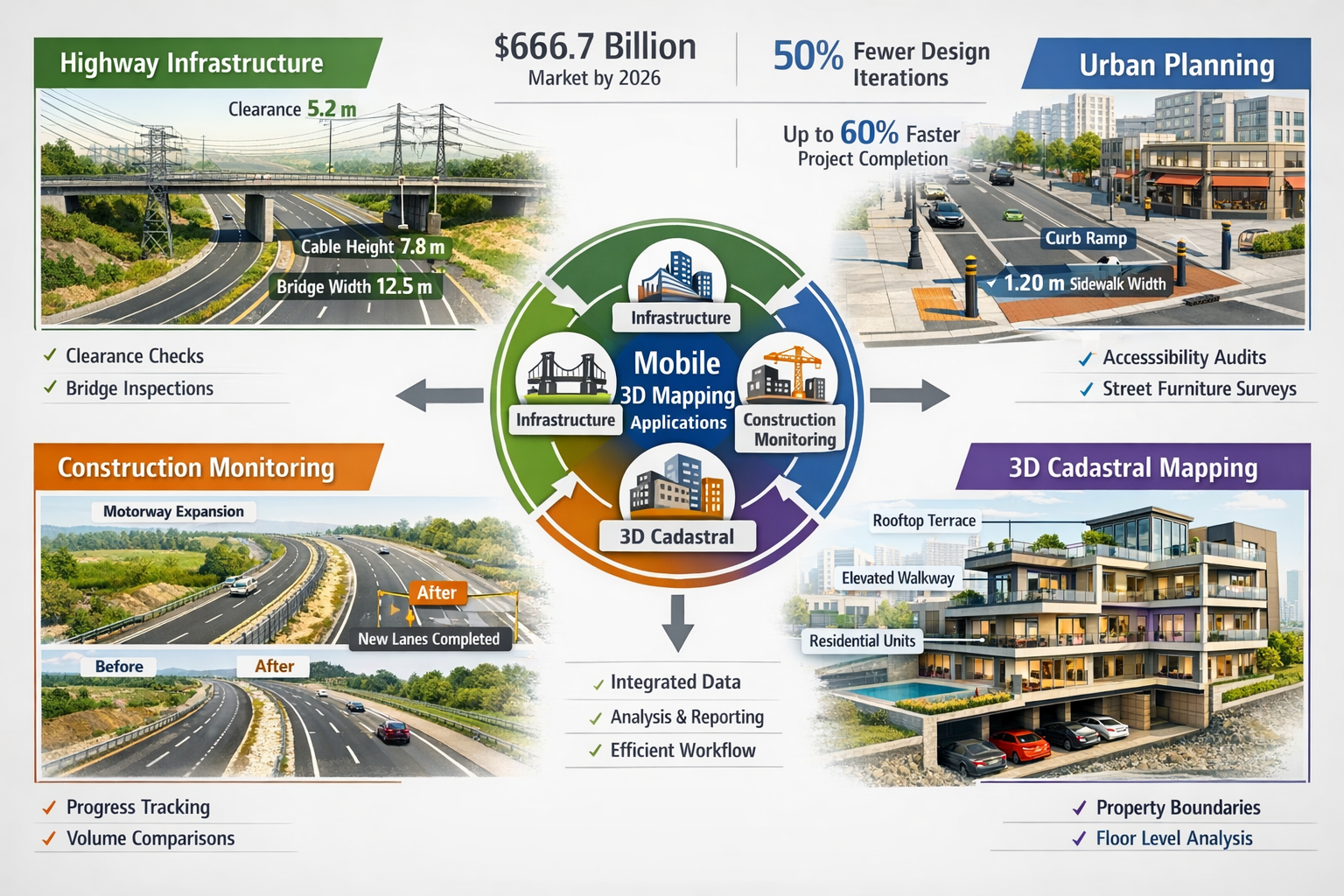
This technological leap forward isn't just about speed—it's about accessibility, accuracy, and integration. Modern mobile mapping solutions have become lighter, smarter, and more powerful, enabling surveyors to create detailed 3D models of properties both indoors and outdoors with unprecedented efficiency. The global mobile mapping market reflects this transformation, projected to reach $66.7 billion by 2026, growing from $27.3 billion in 2021—a remarkable compound annual growth rate of 19.5%[5].
Key Takeaways
- 📱 Mobile mapping systems reduce on-site surveying time from weeks to half a day while maintaining accuracy and delivering complex 3D models suitable for BIM integration[4]
- 💰 The mobile mapping market is experiencing explosive growth, projected to reach $66.7 billion by 2026, driven by demand for efficient digital twin creation[5]
- 🏗️ Point cloud data integrates seamlessly with BIM software like Revit and Civil 3D, reducing design iterations by approximately 50% on complex construction sites[2]
- 🎯 Modern mobile mapping hardware operates without GPS systems, providing accurate instant results through automated processing while being durable and field-resistant[1]
- 🌆 Applications span from construction monitoring to urban planning, with cities adopting mobile mapping for street audits, infrastructure surveys, and 3D cadastral systems[2][4]
Understanding Mobile 3D Mapping Technology for Property Surveys
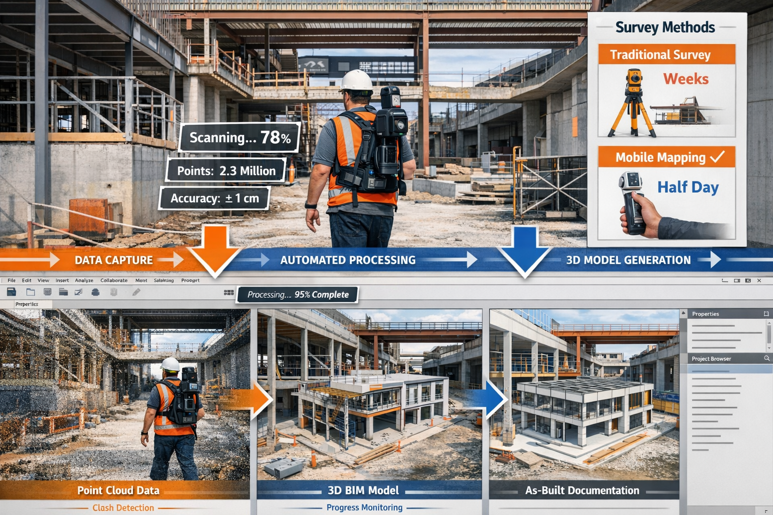
Mobile 3D mapping represents a fundamental shift in how professionals approach property documentation. Unlike traditional static surveying methods that require setting up tripod-mounted equipment at multiple locations, mobile mapping systems capture spatial data continuously while the surveyor moves through the environment. This dynamic approach dramatically accelerates data collection while maintaining the accuracy required for professional applications.
Core Components of Mobile Mapping Systems
Modern mobile mapping platforms combine several sophisticated technologies into compact, portable packages:
LiDAR (Light Detection and Ranging) Sensors emit laser pulses that bounce off surfaces, measuring distances with millimeter-level precision. These sensors can capture millions of data points per second, creating dense point clouds that represent the physical environment in three dimensions.
High-Resolution Cameras work in tandem with LiDAR to capture visual information, adding color and texture to the geometric data. Advanced systems in 2026 feature 4K and higher resolution cameras that enable photorealistic digital twins[4].
Inertial Measurement Units (IMUs) track the device's position and orientation as it moves through space. Combined with advanced algorithms, these sensors enable GPS-free operation—crucial for indoor surveying where satellite signals are unavailable[1].
Real-Time Processing Units analyze data on-the-fly, providing immediate feedback to surveyors and enabling quality control during capture rather than after returning to the office.
How Mobile 3D Mapping Creates Digital Twins
The process of creating digital twins through mobile 3D mapping follows a streamlined workflow:
- Data Capture: The surveyor walks through the property with the mobile mapping device, systematically covering all areas of interest
- Automated Registration: Software algorithms align multiple scans automatically, creating a unified coordinate system
- Point Cloud Generation: Raw sensor data transforms into a dense point cloud representing every surface
- Mesh Creation: Algorithms convert point clouds into 3D mesh models with surfaces and textures
- Digital Twin Finalization: The complete model integrates measurements, annotations, and metadata
This entire process, which once took weeks using traditional methods, can now be completed in half a day for many properties[4], representing a transformational improvement in efficiency.
Hardware Advancements Enabling Efficient Mobile 3D Mapping for Property Surveys
The rapid evolution of mobile mapping hardware has been instrumental in making Mobile 3D Mapping for Property Surveys: Creating Digital Twins Indoors and Outdoors Efficiently a practical reality for professionals across the construction and development sectors.
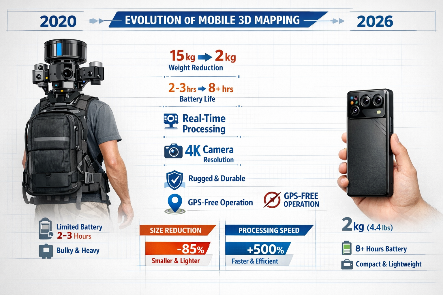
The Evolution Toward Lighter, More Capable Devices
Early mobile mapping systems required heavy backpack-mounted rigs weighing 15 kilograms or more, limiting their practicality for extended surveys. The landscape in 2026 looks dramatically different. Modern devices have become smaller and lighter with more advanced camera resolution and real-time processing capabilities[4], making the technology accessible to a broader range of professionals.
Current generation handheld mobile mappers typically weigh between 1.5 to 3 kilograms, enabling surveyors to conduct comprehensive property surveys without physical fatigue limiting data quality or coverage. This weight reduction hasn't come at the expense of capability—quite the opposite.
Recommended Hardware Categories for Different Applications
| Device Category | Best For | Typical Range | Key Features |
|---|---|---|---|
| Handheld Mobile Mappers | Interior spaces, detailed documentation | 0-30 meters | Compact, GPS-free, high-resolution cameras |
| Backpack Systems | Large facilities, campus surveys | 0-100 meters | Extended battery, 360° coverage, rapid capture |
| Drone-Mounted LiDAR | Exterior facades, rooftops, large sites | 50-300 meters | Aerial perspective, inaccessible areas |
| Vehicle-Mounted Systems | Infrastructure, street-level surveys | 100+ meters | High-speed capture, road networks |
The drone mapping market alone is expected to exceed $6.5 billion by 2026[7], reflecting the growing demand for aerial survey solutions that complement ground-based mobile mapping.
Field Durability and Practical Considerations
Professional surveying occurs in challenging environments—construction sites with dust and vibration, outdoor locations with varying weather, and occupied buildings where equipment must be unobtrusive. Modern mobile mapping products are engineered to be durable and field-resistant[1], featuring:
- ✅ IP-rated enclosures protecting against dust and moisture
- ✅ Shock-resistant housings surviving accidental drops
- ✅ Extended battery systems supporting full-day operation
- ✅ Intuitive interfaces enabling operation with minimal training
These practical improvements have been crucial in transitioning mobile mapping from specialized applications to everyday surveying tools. When conducting a building survey, the ability to capture comprehensive 3D data quickly adds tremendous value to traditional assessment methods.
GPS-Free Operation for Indoor Environments
One of the most significant technological achievements enabling efficient indoor digital twin creation is the development of robust SLAM (Simultaneous Localization and Mapping) algorithms that function without GPS signals. These systems use visual and geometric features to track position and orientation, enabling accurate surveys in:
- 🏢 Multi-story buildings with complex floor plans
- 🏭 Industrial facilities with metal structures that block signals
- 🏗️ Underground spaces and basements
- 🏛️ Historic buildings where external reference points may be limited
This capability has opened entirely new applications for mobile mapping technology, particularly in construction and condition surveys where interior documentation is essential.
Software Solutions and Workflows for Processing Mobile Mapping Data
Hardware capabilities mean little without powerful software to transform raw data into actionable digital twins. The software ecosystem supporting Mobile 3D Mapping for Property Surveys: Creating Digital Twins Indoors and Outdoors Efficiently has matured significantly, offering solutions ranging from automated processing to advanced BIM integration.
Automated Processing Pipelines
Modern mobile mapping software emphasizes automation and speed, recognizing that surveyors need results quickly to maintain project momentum. Leading platforms in 2026 offer:
One-Click Processing: Upload raw data from mobile mapping devices and receive processed point clouds within hours, not days. Algorithms automatically handle registration, noise filtering, and coordinate system alignment.
AI-Powered Feature Extraction: Machine learning models automatically identify and classify building elements—walls, floors, ceilings, doors, windows, and fixtures—reducing manual annotation time by up to 80%.
Quality Control Dashboards: Real-time metrics showing coverage completeness, point density, and accuracy statistics help surveyors verify data quality before leaving the site.
According to industry professionals, mobile mapping systems can deliver accurate instant results that can be processed rapidly through automated software[1], fundamentally changing project timelines.
BIM Integration and Clash Detection
The true power of mobile 3D mapping emerges when digital twins integrate with Building Information Modeling workflows. Point clouds from mobile mapping surveys integrate seamlessly into BIM software such as Revit and Civil 3D[2], enabling several critical applications:
As-Built Documentation: Compare actual site conditions against original design models to identify discrepancies before they become costly problems.
Clash Detection: Overlay proposed MEP (mechanical, electrical, plumbing) systems onto accurate 3D models of existing spaces to identify conflicts early in the design process. This approach has been shown to reduce design iterations by approximately 50% on complex sites[2].
Progress Monitoring: Conduct repeat scans throughout construction to track progress against schedules and verify work quality. A motorway widening scheme demonstrated how this approach kept projects on schedule while producing as-built documentation for handover[2].
Renovation Planning: For property renovations that add value, accurate as-built models eliminate guesswork and enable precise material estimation.
Software Tutorial: Basic Workflow for Creating Digital Twins
While specific software varies, most mobile mapping workflows follow this general pattern:
Step 1: Data Import and Organization
- Transfer scan data from mobile device to processing workstation
- Organize scans by location, date, and project phase
- Verify data completeness and coverage
Step 2: Automated Registration
- Run automated alignment algorithms to merge multiple scans
- Review registration quality metrics
- Manually adjust any problematic alignments
Step 3: Point Cloud Cleanup
- Apply noise filters to remove spurious points
- Crop unnecessary areas (sky, distant objects)
- Classify points by surface type (ground, vegetation, building)
Step 4: Mesh Generation
- Convert point cloud to triangulated mesh surface
- Apply texture mapping from camera imagery
- Optimize mesh density for intended use
Step 5: Measurement and Annotation
- Extract dimensions, areas, and volumes
- Add annotations for features of interest
- Generate cross-sections and elevation views
Step 6: Export and Delivery
- Export to client-specified formats (DWG, RVT, IFC, PDF)
- Generate visualization materials (renderings, fly-throughs)
- Package deliverables with metadata and documentation
Professional surveyors conducting Level 3 full building surveys increasingly incorporate mobile mapping data to supplement traditional inspection methods, providing clients with comprehensive documentation.
Cloud-Based Collaboration Platforms
The shift toward cloud-based processing and storage has enabled new collaboration models. Project stakeholders can:
- 🌐 Access digital twins from anywhere via web browsers, eliminating software installation barriers
- 👥 Collaborate in real-time with annotations and markups visible to entire teams
- 📊 Track changes over time through version control and comparison tools
- 🔒 Maintain security through role-based access controls and encryption
These capabilities are particularly valuable for project management teams coordinating multiple stakeholders across distributed locations.
Real-World Applications: Construction and Development Surveys
The practical applications of Mobile 3D Mapping for Property Surveys: Creating Digital Twins Indoors and Outdoors Efficiently extend across the entire construction and development lifecycle, delivering tangible benefits at each stage.
Pre-Construction: Topographic Baselines and Site Analysis
Before breaking ground, developers need comprehensive understanding of site conditions. Mobile mapping delivers pre-build topographic baselines[2] that capture:
- Terrain modeling with accurate elevation data for grading and drainage planning
- Existing structure documentation when renovating or expanding facilities
- Vegetation and obstacle mapping for site clearance planning
- Access route analysis for equipment and material delivery
For property development projects, this comprehensive baseline data reduces surprises during construction and enables more accurate cost estimation.
Active Construction: Progress Monitoring and Quality Control
During construction, mobile mapping enables real-time progress monitoring through repeat scans[2]. Surveyors can:
- Verify construction against plans by comparing actual work to design models
- Detect deviations early before they compound into major issues
- Document construction phases for records and dispute resolution
- Measure quantities for progress payments and material tracking
The ability to conduct these surveys quickly—often during a single site visit—minimizes disruption to ongoing work while providing project managers with actionable intelligence.
Post-Construction: As-Built Documentation and Facility Management
Upon project completion, accurate as-built documentation becomes essential for facility management and future modifications. Mobile mapping provides:
- Comprehensive facility records showing all building systems and spaces
- Maintenance planning data for equipment access and replacement
- Space utilization analysis for operational optimization
- Baseline for future renovations eliminating re-surveying needs
Understanding what questions to ask during a building survey becomes easier when comprehensive 3D documentation is available for reference.
Infrastructure Surveys: Highways, Utilities, and Public Works
Mobile mapping is transforming highway and infrastructure surveys by capturing 3D contextual data for overhead cables, substations, and pipe bridges to aid maintenance planning[2]. Key applications include:
Highway Asset Management: Street-level mobile mapping captures road surfaces, signage, barriers, and markings, creating comprehensive inventories for maintenance scheduling.
Utility Corridor Documentation: Accurate 3D models of above-ground infrastructure support planning while minimizing disruptions and reducing unnecessary excavation[2] during maintenance activities.
Bridge and Structure Inspection: Regular mobile mapping surveys document structural conditions over time, supporting predictive maintenance programs.
Urban Planning: Street Audits and Smart City Initiatives
Cities are adopting mobile mapping for street audits capturing footways, bollards, and traffic calming infrastructure[2], supporting multiple urban planning objectives:
Active Travel Planning: Detailed documentation of sidewalks, bike lanes, and crossings supports infrastructure improvements encouraging walking and cycling.
Accessibility Audits: Mobile mapping identifies barriers for wheelchairs and bicycles, supporting inclusive urban design that serves all residents[2].
Smart City Integration: 3D city models derived from mobile mapping data drive stakeholder visualizations and improve IoT system efficiency through asset tracking of signals and waste bins[2].
Planning Model Updates: Councils are using these surveys to update planning models post-development for long-term strategic planning[2], ensuring regulations reflect actual built conditions.
3D Cadastral Systems: The Future of Property Registration
Several countries are implementing 3D cadastral systems to accurately represent multi-level urban structures. Switzerland, the Netherlands, and Singapore have begun pilot projects or partial implementations[4], addressing challenges like:
- 🏢 Condominium ownership in multi-story buildings
- 🚇 Underground infrastructure including parking and transit
- 🌉 Elevated structures such as walkways and transit stations
- 🏗️ Complex developments with overlapping property rights
Mobile 3D mapping provides the efficient data capture method needed to make these sophisticated cadastral systems practical at scale.
Overcoming Challenges and Maximizing Efficiency
While Mobile 3D Mapping for Property Surveys: Creating Digital Twins Indoors and Outdoors Efficiently offers tremendous advantages, professionals must navigate certain challenges to maximize return on investment.
Managing Data Volume and Storage
High-density point clouds generate substantial data volumes—a comprehensive building survey can easily produce 50-100 gigabytes of raw data. Effective data management strategies include:
- Progressive decimation: Reduce point density in less critical areas while maintaining detail where needed
- Cloud storage with tiered access: Keep active projects on fast storage, archive completed projects to lower-cost solutions
- Format optimization: Use compressed formats that maintain accuracy while reducing file sizes
- Retention policies: Define how long raw data must be retained versus processed deliverables
Ensuring Accuracy and Quality Control
While mobile mapping systems offer impressive accuracy, professionals must implement quality control procedures:
✅ Calibration protocols: Regular equipment calibration ensures consistent accuracy
✅ Control point verification: Establish known reference points to validate survey accuracy
✅ Overlap requirements: Ensure adequate overlap between scans for reliable registration
✅ Environmental considerations: Understand how lighting, reflective surfaces, and weather affect data quality
For professionals conducting construction and condition surveys, combining mobile mapping with traditional inspection methods provides comprehensive assessment while leveraging the strengths of each approach.
Training and Skill Development
Maximizing the value of mobile mapping technology requires investment in professional development:
Technical Training: Understanding equipment operation, data capture best practices, and troubleshooting
Software Proficiency: Mastering processing software to efficiently transform raw data into deliverables
Application Knowledge: Knowing when mobile mapping is the optimal solution versus alternative methods
Client Communication: Explaining capabilities and limitations to manage expectations effectively
The reasons why property owners hire surveyors increasingly include access to advanced technologies like mobile 3D mapping that traditional methods cannot match.
Cost-Benefit Analysis for Implementation
Organizations considering mobile mapping investment should evaluate:
| Cost Factors | Benefit Factors |
|---|---|
| Equipment purchase ($15,000-$100,000+) | Reduced field time (weeks to days) |
| Software licenses ($2,000-$10,000/year) | Expanded service offerings |
| Training and certification | Higher project margins |
| Data storage infrastructure | Competitive differentiation |
| Maintenance and updates | Improved client satisfaction |
For many firms, the dramatic reduction in on-site time—from weeks to half a day[4]—alone justifies the investment, particularly when considering labor costs and project throughput.
Integration with Existing Workflows
Successful adoption requires thoughtful integration with established processes:
Phased Implementation: Start with pilot projects before full deployment across all services
Hybrid Approaches: Combine mobile mapping with traditional methods where each excels
Client Education: Help clients understand new deliverable formats and capabilities
Process Documentation: Standardize workflows to ensure consistency across projects
When conducting Level 3 full building surveys, mobile mapping can supplement traditional inspection while providing clients with enhanced documentation.
Future Trends: What's Next for Mobile 3D Mapping Technology
The mobile mapping landscape continues evolving rapidly, with several emerging trends poised to further enhance Mobile 3D Mapping for Property Surveys: Creating Digital Twins Indoors and Outdoors Efficiently.
Artificial Intelligence and Automated Analysis
AI integration is moving beyond basic feature extraction toward intelligent analysis and insights:
Defect Detection: Machine learning models trained to identify structural issues, water damage, and material deterioration automatically flag concerns for surveyor review.
Change Detection: AI algorithms compare sequential scans to highlight modifications, supporting property management and compliance verification.
Predictive Maintenance: Analysis of historical scan data identifies deterioration patterns, enabling proactive intervention before failures occur.
Automated Reporting: Natural language generation creates preliminary survey reports from 3D data, reducing documentation time.
Real-Time Collaboration and Remote Inspection
Connectivity improvements enable live streaming of mobile mapping data, supporting:
- 👨💼 Remote expert consultation during on-site surveys
- 🎥 Client walkthroughs of properties without physical presence
- 🔍 Quality control by senior staff reviewing junior surveyor work in real-time
- 📡 Immediate decision-making based on fresh data
Integration with IoT and Smart Building Systems
Digital twins created through mobile mapping increasingly serve as platforms for integrating sensor data from building systems:
- 🌡️ Environmental monitoring overlaid on spatial models
- ⚡ Energy consumption visualized by space and system
- 🚨 Security system integration showing coverage and blind spots
- 🔧 Maintenance scheduling based on equipment location and access
Miniaturization and Smartphone Integration
The trajectory toward smaller, more accessible devices continues. Emerging solutions include:
Smartphone-Based Scanning: LiDAR-equipped smartphones offer entry-level mobile mapping capabilities, democratizing access to 3D capture technology.
Wearable Systems: Helmet-mounted and glasses-integrated scanners enable hands-free operation during inspections.
Modular Accessories: Clip-on sensors that enhance standard devices with professional-grade capabilities.
Enhanced Outdoor-Indoor Transition
Current systems often require separate workflows for exterior and interior spaces. Next-generation platforms promise seamless outdoor-indoor transition, automatically adjusting sensor parameters and processing algorithms as surveyors move between environments.
Regulatory Evolution and Standards Development
As mobile mapping becomes standard practice, industry standards and regulatory frameworks are evolving:
- 📋 Accuracy specifications for different application types
- 🏛️ Admissibility standards for legal and insurance purposes
- 🎓 Certification programs for operators and processors
- 🔐 Data security requirements for sensitive properties
Understanding new property management laws becomes increasingly important as digital documentation requirements evolve.
Conclusion: Embracing the Digital Twin Revolution
Mobile 3D Mapping for Property Surveys: Creating Digital Twins Indoors and Outdoors Efficiently represents far more than incremental improvement—it's a fundamental transformation in how professionals document, analyze, and manage the built environment. The technology has matured from specialized application to practical everyday tool, driven by hardware that's become lighter and more capable, software that automates complex processing, and market demand reflected in projected growth to $66.7 billion by 2026[5].
The benefits are compelling and measurable: surveying time reduced from weeks to half a day[4], design iterations cut by 50%[2], and comprehensive digital twins that support applications from construction monitoring to urban planning. Organizations that embrace these tools position themselves at the forefront of an industry undergoing rapid digital transformation.
Actionable Next Steps for Professionals
For Surveying Firms:
- 🎯 Evaluate current project types to identify where mobile mapping delivers maximum value
- 💡 Conduct pilot projects with rented equipment before major capital investment
- 📚 Invest in training to build internal expertise and capabilities
- 🤝 Educate clients about enhanced deliverables and new possibilities
For Property Developers and Managers:
- 📋 Request mobile mapping deliverables when commissioning building surveys
- 🏗️ Integrate digital twins into project management and facility operations
- 📊 Establish data standards for consistent documentation across portfolio
- 🔄 Plan for periodic updates to maintain current facility records
For Construction Professionals:
- ✅ Incorporate mobile mapping into quality control procedures
- 📐 Use digital twins for clash detection before installation
- 📸 Document progress through regular scans for records and claims defense
- 🎓 Develop BIM integration skills to maximize data utility
For Urban Planners and Public Agencies:
- 🌆 Deploy mobile mapping for comprehensive asset inventories
- ♿ Conduct accessibility audits to identify infrastructure improvements
- 🗺️ Build 3D city models supporting visualization and analysis
- 📱 Explore smart city integration connecting physical and digital infrastructure
The future of property surveying is digital, three-dimensional, and increasingly automated. Mobile 3D mapping technology provides the bridge between physical reality and digital representation, enabling professionals to work faster, more accurately, and with greater insight than ever before. Organizations that master these tools today will lead the industry tomorrow, delivering superior value to clients while operating more efficiently than competitors relying on traditional methods alone.
Whether conducting detailed construction surveys, managing complex property portfolios, or planning urban infrastructure, mobile 3D mapping offers capabilities that were unimaginable just a few years ago. The technology is mature, the business case is proven, and the competitive advantages are clear. The question is no longer whether to adopt mobile mapping, but how quickly organizations can integrate these powerful tools into their professional practice.
References
[1] The Future Of Land Surveying Technology And Upcoming Trends In 2026 – https://metricop.com/blogs/land-surveying/the-future-of-land-surveying-technology-and-upcoming-trends-in-2026
[2] Real World Applications Of Mobile Mapping Systems – https://castlesurveys.co.uk/real-world-applications-of-mobile-mapping-systems/
[3] Future Land Surveying 2026 – https://haller-blanchard.com/future-land-surveying-2026/
[4] Surveying Geospatial Industry Trends 2025 Ai Mobile Mapping 3d – https://www.geoweeknews.com/blogs/surveying-geospatial-industry-trends-2025-ai-mobile-mapping-3d
[5] Mobile Mapping – https://www.marketsandmarkets.com/PressReleases/mobile-mapping.asp
[6] Doubling Down On Digital – https://amerisurv.com/2026/02/01/doubling-down-on-digital/
[7] Aerial Survey Companies – https://www.extremeaerialproductions.com/post/aerial-survey-companies
[8] 3dsurvey Is The Best Photogrammetry Software In 2026 – https://3dsurvey.si/3dsurvey-is-the-best-photogrammetry-software-in-2026/